Real-time U.S. severe weather alerts. Tornado Warnings, Destructive & Considerable Severe T-Storms, and Catastrophic Flash Flood Warnings. Powered by Forecastix
Forecastix is your partner for severe weather coverage.
We automatically post real-time weather alerts, maps, and updates to 5 platforms, plus SMS and email, with powerful customization options designed for pages, communities, and individuals.
Learn more: https://t.co/QTO9HUZMn1
Flash Flood Warning continues for Nowata, OK until 11:00 PM 6/26/26. Life-threatening flash flooding from heavy rain is ongoing; 1–2 in/hr possible. Turn around, don’t drown—avoid flooded roads, creeks, and underpasses.
Flash Flood Warning for Washington, OK until 11:00 PM CDT. Life-threatening flash flooding from heavy rain (3-5" already; 1-2"/hr possible). Turn around, don’t drown—avoid flooded roads/underpasses and stay out of creeks/streams.
Severe T-Storm Watch for Box Butte, NE until 11 PM MDT. Conditions favorable for severe storms. Monitor the sky and stay alert for Severe Thunderstorm Warnings.
Severe Thunderstorm Warning for Dallam & Hartley until 10:00 PM CDT. 80 mph wind gusts and damaging flying debris possible. Mobile homes may be heavily damaged. Move to an interior room on the lowest floor.
Severe T-Storm Watch for Clark, KS & Others until 3 AM CDT. Conditions favorable for severe storms. Watch for Warnings and be ready for damaging winds, large hail, and heavy rain.
Flash Flood Warning continues for Clark, IN & Others until 12:15 AM 6/27/26. Life-threatening flash flooding is occurring. 1-3" rain already fell; more 0.5-1" possible. Turn around, don’t drown—move to higher ground now.
Tornado Warning for Cheyenne, CO until 8:30 PM MDT. Tornado and ping pong ball size hail. A confirmed tornado is on the ground near Cheyenne Wells. Take cover now—basement/interior room, away from windows; protect vehicles/mobile homes.
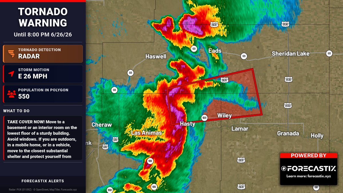
Severe Thunderstorm Warning remains in effect for Bent and Prowers Counties until 8:00 PM 6/26/26. 80 mph wind gusts and 1.25 in hail possible. Destructive flying debris; mobile homes and roofs/trees may be damaged. Move to an interior room on lowest floor. & Others
Severe Thunderstorm Warning for Payne, OK until 9:15 PM CDT. 80 mph wind gusts and 1.5 in hail possible; destructive storms. Flying debris and damage to roofs/windows/vehicles; power outages likely. Get to an interior room/basement now.
Flash Flood Warning for Montgomery, KS until 12:45 AM CDT. Life-threatening flash flooding from heavy rain is ongoing/expected. 1-3" more rain possible. Do not drive into flooded areas; turn around, don’t drown.
Tornado Warning for Kiowa, CO until 8:15 PM MDT. Tornado and golf ball size hail possible. Radar shows rotation. Take cover now—basement or interior room on lowest floor; avoid windows; protect from flying debris.
Tornado Warning for Noble, OK & Payne, OK until 8:45 PM 6/26/26. Tornado and ping pong ball size hail possible. Radar shows rotation. Take cover now in a storm shelter/safe room; avoid windows.
Tornado Warning for Bent, CO, Kiowa, CO & Prowers, CO until 8:00 PM MDT. Tornado and ping pong-ball hail possible; radar shows rotation. Take cover now—basement/interior room lowest floor; avoid windows.
Severe Thunderstorm Warning for Noble, OK & Payne, OK until 8:15 PM CDT. 80 mph wind gusts and 1.5" hail. Destructive storm possible with dangerous flying debris. Get to interior room/basement now; watch for tornadoes.
Dust Storm Warning for Luna, NM until 7:30 PM MDT. Dangerous dust with <1/4 mi visibility and winds >40 mph. Travel may be life-threatening; I-10, Hwy 11 & Hwy 9 could be impacted. Pull off road, turn off lights, keep foot off brake.
Severe Thunderstorm Warning for Garfield, OK & Noble, OK until 7:30 PM. 80 mph winds and 1.75" hail possible, incl destructive debris. Mobile homes may be heavily damaged. Move to an interior room on lowest floor.
Flash Flood Warning continues for Cherokee, KS until 12:30 AM 6/27/26. Life-threatening flash flooding ongoing; 2-4" rain already, more up to 2" possible. Turn around, don’t drown—avoid flooded roads/underpasses.
Severe Thunderstorm Warning for Garfield, OK & Noble, OK until 7:00 PM CDT. 80 mph wind gusts and 2.5 in hail possible; destructive winds may overturn mobile homes. Move to an interior room on lowest floor, away from windows.
Tornado Warning for Douglas, MO until 7:15 PM. Radar indicated rotation with a tornado possible. Flying debris will be dangerous; mobile homes may be damaged. Take cover now in a basement or interior room away from windows.