We’ve decided to develop a map-guessing game that turns much of our existing content into an interactive experience.
The goal is simple: grow our brand while making geography education more engaging and fun.
What would you like to see in the game? Any ideas or features you’d love to play?
Spain and Switzerland sat the whole war out (grey on the map). Which late entry surprised you most? Follow @forummapping for more maps. Borders: HistoGIS (CC BY 4.0)
In 1914 most of Europe's great powers were at war within weeks. Italy waited until 1915, Romania until 1916, Greece until 1917. One map of who fought in WWI and when they joined.
a thread 🧵🗺️
6/ Greece was split. King Constantine I favoured neutrality, while Venizelos set up a rival government in Thessaloniki in 1916. Greece formally joined the Allies on 30 June 1917.
Europe's death rate runs from 5.7 per 1,000 in Turkey to 15.6 in Bulgaria. Age structure explains much of the gap: young populations bury fewer people.
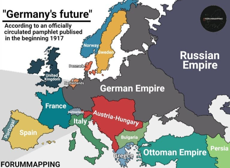
7/ So this map is propaganda-flavoured fantasy, but not pure fantasy: it shows what Germany's planners wanted. Which part surprises you most? Follow @forummapping for more maps like this.
This map claims to show "Germany's future" as imagined in a pamphlet circulated in early 1917. Notice what happens to Belgium, Poland and the Baltic coast.
a thread 🧵🗺️
6/ Russia lost roughly a third of its population and most of its coalfields in that treaty (about 34% and 89% of the former empire's, per Wikipedia). It was annulled in November 1918 after the Armistice.