Weather forecast and info for southeast Wisconsin from the FOX6 Weather Experts: Rob Haswell, Tom Wachs, Stephanie Barichello, Lisa Michaels and Holly Baker
6/22 10:23pm: Another beautiful day on Tuesday, cooler near the lake. Morning rain/non-severe storms on Wednesday (heavy rain possible). Scattered severe storms with wind/hail possible Wednesday afternoon/evening. Temperatures in the 70s through the end of the week. Summertime heat and humidity will return starting Sunday and continuing through most of next week.
Here is the latest on the low end severe weather threat for Wednesday 6/24. Heavy rain is the greatest threat, but some hail/wind is possible if storms can get strong enough. Tuesday will be quiet with highs in the 60s near the lake/70s inland. Posted: Mon. 6/22. 9:25pm.
Sun. 6/21 10:21pm: We have a below average week ahead in terms of temperatures, although comfortable for late June. T-Storm chances return on Wednesday and Friday. Widespread severe weather is not expected at this time. Enjoy this "cooler" weather now because the summertime heat will likely build in next week (week of 6/29).
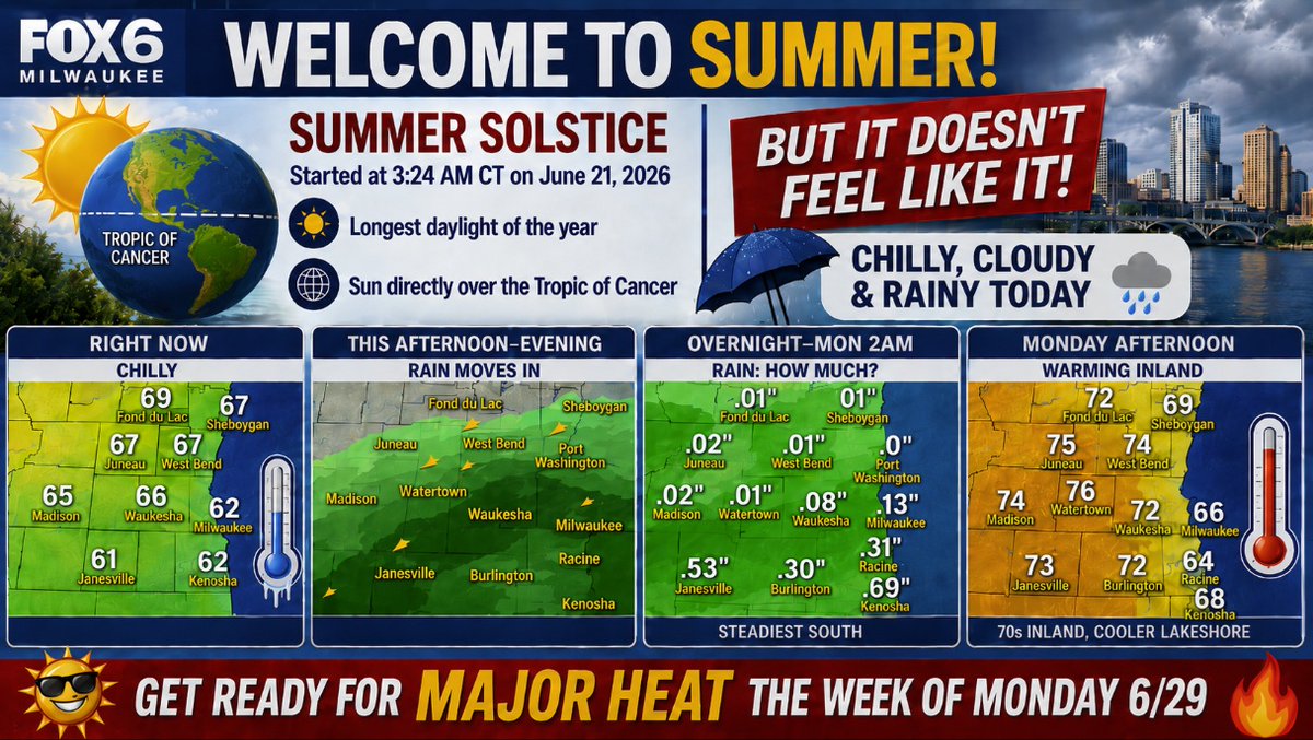
Welcome to Summer! I know...it didn't feel like it today. Rain will move out overnight. Cooler near the lake on Monday and Tuesday. Where is the summer heat? It is coming, but it won't be here until next week (week of 6/29). So enjoy these cooler temperatures and low humidity levels while we still have them! 😀
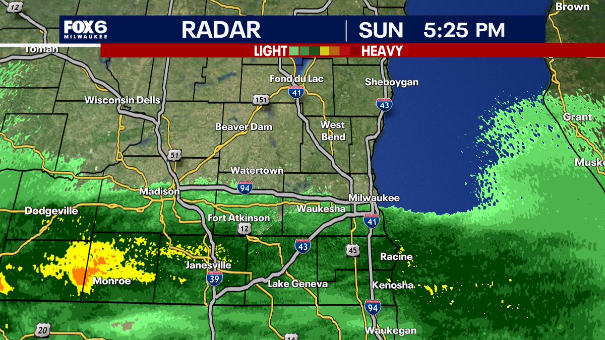
5:25pm Sun. 6/21: The rain is stopping right around the I-94 corridor! Don't expect this sharp cutoff to move too much tonight. So if you are north...no rain. If you are Milwaukee and south...you've got the rain. Steadiest rain near the IL border. The rain will end overnight.
Sunday 6/21 3:07pm: Happy Father's Day to all the Dads! We made it through the Road America race without any rain. The rain will move in over the next few hours from the south. Heaviest rain (0.25"-0.75") along the IL border. 0.10"-0.25" Milwaukee/I-94 corridor. Lesser amounts north. This rain will end overnight. Dry and partly sunny on Monday. 74 inland, 65 lake with a northeast wind. Big time heat starts in a little over a week.
6/21 10:45 AM
Happy Father's Day! We are tracking a chance for incoming rain this afternoon/ evening. Take advantage while its dry outdoors and be sure to keep the umbrella close.
https://t.co/8PEkdfmuNh
-Holly Baker
6/20 10:15 PM
Father's Day starts off cloudy before the rain rolls in during the after noon and evening. Temperatures will remain in the 70s for the upcoming week with several chances of rain to be possible.
https://t.co/8PEkdfmuNh
-Holly Baker
I'm getting a lot of questions...where is the heat? When will it feel like summer? Answer: Early July. Here is more. Are you a fan of this cooler weather or do you like it hot and humid? Posted: Fri. 6/19/26
Fri. 6/19: Prepare for some rain if you are heading to Summerfest tonight. Light rain and possibly a rumble or two this evening. Temperatures in the 60s.
Fri. 6/19 3:34pm: We've got rain moving in. Showers and a few rumbles possible this evening. This rain will move out overnight. But if you are heading to Summerfest or anything outside, prepare for some rain. Less than 0.25" of rain expected. Temperatures dropping into the 60s this evening.
Thu. 6/18 11:21pm: Beautiful day on Friday for Juneteenth and Summerfest. Rain moves in after 7-8pm. So take a poncho to Summerfest Friday night. Nice day on Saturday and then rain on Sunday for Father's Day. Some heavy rain possible, especially near the Illinois border.
Thu 6/18 10:45pm: 4 tornadoes touched down in southwest and south central Wisconsin on Wednesday, June 17, 2026. A long-track EF-2 tornado touched down in Iowa and crossed into Wisconsin. It was on the ground for over 30 miles. This same cell produced an EF-1 near Boscobel, another EF-1 near Ridgeway and another EF-1 near Belleville. This was the same cell that went through southern Walworth county prompting the tornado warning. No touchdowns reported in Rock or Walworth counties. #tornado #Wisconsin
9:39pm Wed. 6/17: Well, storms aren't quite done yet. More storms have developed north of Milwaukee moving east. This should stay north of the Garth Brooks concert. These storms are not severe and will move out overnight.
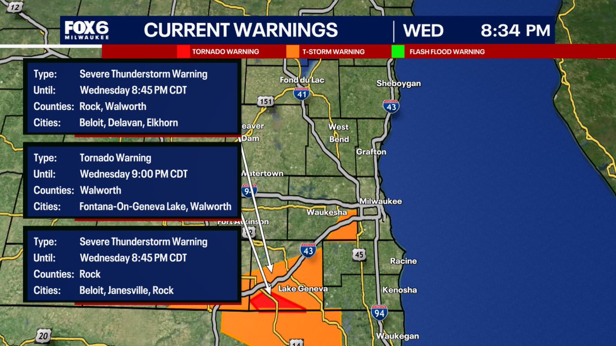
9:04pm Wed. 6/17: The Tornado Warning has expired. A Severe T-Storm continues to move through western Kenosha county. This will be in Illinois shortly and then we will be all good. That spun up fast in SW Walworth county!
A Severe Thunderstorm Warning has been issued for parts of SE WI until 6/17 9:30PM. Make sure your cell phone emergency alerts are set to "ON." Tune into FOX6, Download the FOX6 Storm Center App & FOX Local App for the latest information.
A Tornado Warning has been issued for parts of SE WI until 6/17 9:00PM. SEEK SHELTER IMMEDIATELY if you are in the warned area. Tune into FOX6. Download the FOX6 Storm Center App & FOX Local App. More at: https://t.co/8PEkdfmuNh
8:17pm Wed. 6/17: Storms are weakening overall. Strongest storms are in Rock county (ie. Beloit) moving toward IL. Not as concerned now for Walworth or Waukesha counties. Rain will continue moving into Milwaukee county. But a downward trend in intensity. Watching a stronger cell over the interstate west of West Bend right now. That storm has perked up with some hail, wind and heavy rain likely as that rolls into West Bend shortly.
8:02pm Wed. 6/17: Very concerned for Beloit at the moment. Rotation really increasing. Text friends/family in Beloit and tell them to seek shelter. Severe t-storm warnings continue for Walworth and Waukesha Co. until 8:45pm for strong winds. No concerning rotation in our area at this time.
A Severe Thunderstorm Warning has been issued for parts of SE WI until 6/17 8:45PM. Make sure your cell phone emergency alerts are set to "ON." Tune into FOX6, Download the FOX6 Storm Center App & FOX Local App for the latest information.