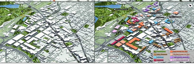
MPS in Geodesign candidate Miles Druce presents “Reinvigorating Rochester: Modifying the I-490 Corridor Utilizing the Geodesign Framework” at the GIS/SIG – Geographic Information Sharing / Special Interest Group https://t.co/xQXzcydBiI via @GIS_SIG. @penn_state#geodesign
Students from @PennState's online #geodesign program participated in a studio project focused on revitalizing @CityofUtica. Learn about the project: https://t.co/1lFhrZuAxx
We're really looking forward to getting back to the #ESRIUC next week. The academic fair will be just outside the map gallery on Monday from 330-6PM. Stop by to say hi and learn more about how you can get a #masters in #geodesign all from the comfort of your own home! #levelup
Graduate students in the geodesign program, which is offered through @PSUWorldCampus, reimagined an 880-acre site east of downtown Toronto near the waterfront in a collaborative studio course under instructor @devlavigne last fall. Story: https://t.co/XJe5wxnFNQ
It’s a great day for #geodesign at the @APA_Planning#NPC22! Three talks today will highlight the benefits of the framework. Come see alumni @Geozenn & @mmeehhaann and faculty @devlavigne talk about using #GIS to help make data driven decisions. #planning
We’re on our way to the @APA_Planning conference! Our alumni and faculty will be speaking in a variety of #geodesign related sessions. If you’re looking to connect and learn more about how to advance your career with a Masters degree, let us know! #NPC22
Going to the @ASLA_PA_DE Annual Meeting? Be sure to check out #Geodesign student Zack Goodwin give his talk titled: "A Geodesign Approach to Urban Planning & Identity" #ASLA#Planning#GIS Friday 4/8 2:15 PM! https://t.co/ZKy8PlNIHs
In this webinar #planners from #Esri will share a modern workflow that enables #cities to #map#equity data, assess community needs & gaps, evaluate project impact, & engage the public at every step along the way. Register:
https://t.co/gwTfZE8dQQ
#GIS#ArcGIS#geodesign#APA
@annaballasiotes We can help you learn more about it! It's a process that uses geospatial tools and tech to systematically address complex landuse issues. The process focuses on how change can best help the people of the place. #GIS is a tool in the #geodesign toolbox. https://t.co/4VGYgkkpxZ
Many think of travel when anticpating Thanksgiving. Check out all the cool new benefits for design and planning for the recently signed transportation bill.
#thanksgiving2021#travel#geodesign#infrastructure#planning
https://t.co/ILvE2042HH
Curious of Geodesign is a good fit for your future? Consider taking a "test run" via GEODZ 511? Below, learn how you can grow your understanding about Geodesign starting in January 2022!
https://t.co/YnoGmbBD5h