Are you signed up for Grays Harbor Emergency Alerts?
Emergencies can happen at anytime, anywhere! GHC Alerts allow Grays Harbor EM to alert you with critical information.
Text "GraysHarborAlerts" to 67283 or visit https://t.co/e6JsofjYm0 to sign up now!
GHC EM: Reminder: Tomorrow October 16th @ 10:16 AM, AHAB sirens in Grays Harbor County will be activated for the Great ShakeOut drill. The activation will feature the actual siren wail not the Westminster Chimes like we are used to hearing. It is only a test.
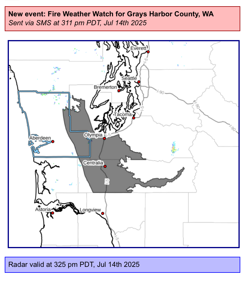
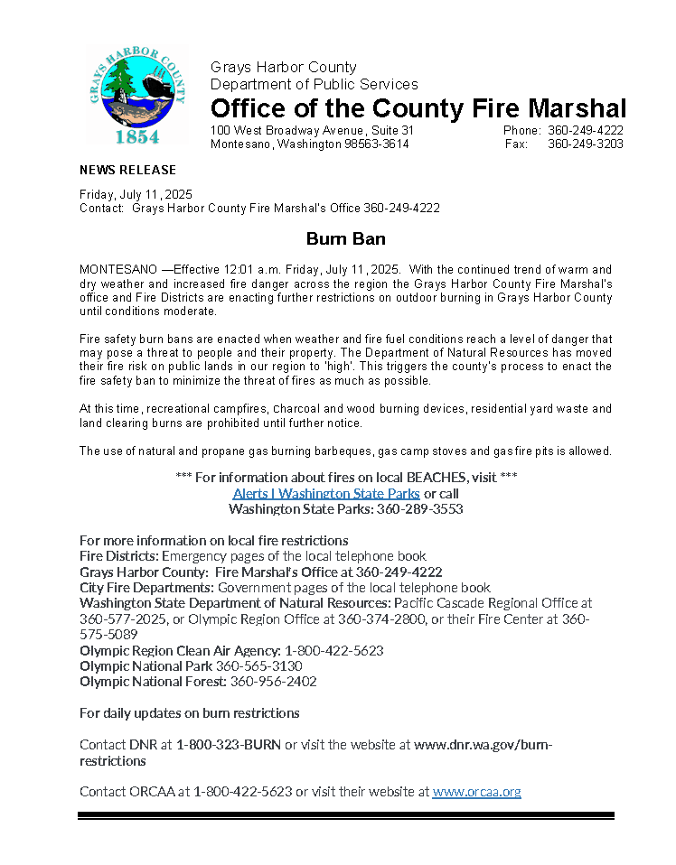
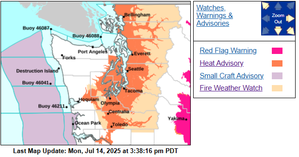
The @NWSSeattle has issued a Red Flag Warning for gusty winds and low relative humidity, which is in effect from 5 AM to 11 PM PDT Tuesday. This is for east Grays Harbor County, but dry and windy conditions will be present everywhere. A Burn Ban is still in effect countywide.
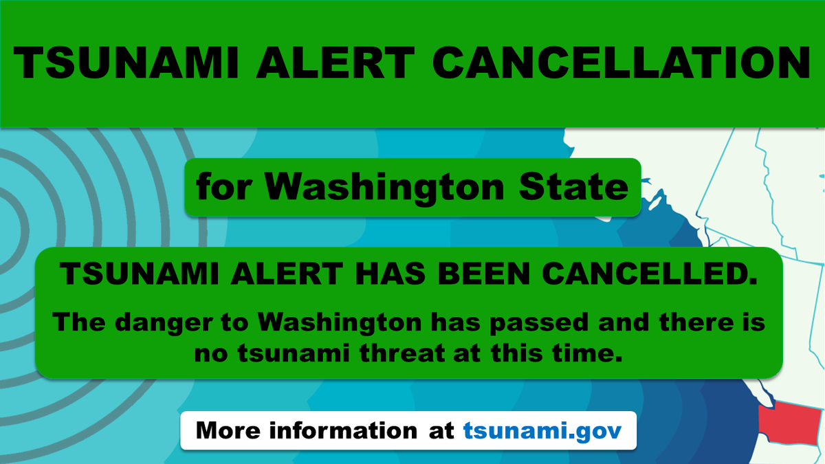
@NWS_NTWC Good news, everyone. The #tsunami advisory for #WaState has been CANCELLED. At this time there is no tsunami threat to the Washington coast. Check out https://t.co/nBaMCAwGAR for more information. #TsunamiAdvisory#WaWX
FINAL UPDATE 07/30/25 - 10:20 AM
ALL TSUNAMI ALERTS HAVE ENDED FOR WASHINGTON STATE.
Local impacts may still be ongoing/possible. Please follow the instructions of local officials who have the authority to determine if it is safe to return to the affected areas.
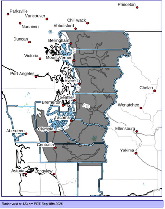
Tsunami Update: 7/30/25 - 12:25 AM
Washington continues to be under a tsunami advisory.
Observations from Canada showed a 45-minute delay compared to the forecasted arrival times provided by the NTWC. We can expect a similar delay to the forecasted times for Washington.
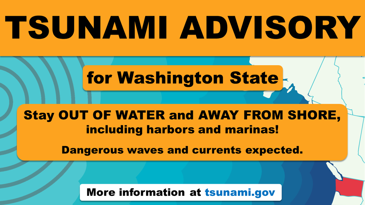
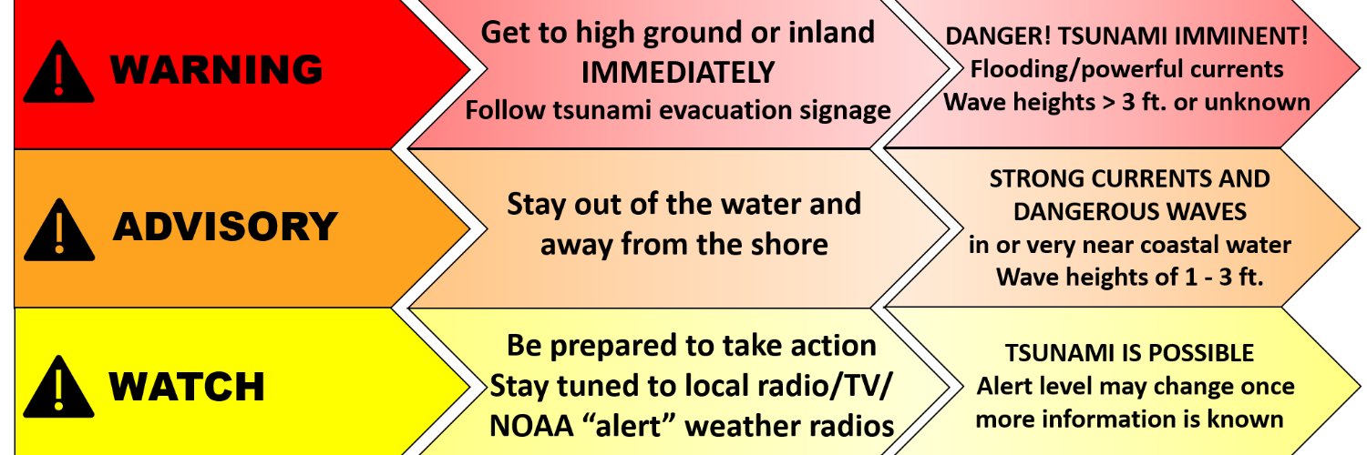
The @NWS_NTWC has now issued a #tsunami ADVISORY for Washington state. If you are on the coast, stay OUT OF THE WATER & AWAY FROM THE SHORE, which includes HARBORS and MARINAS due to strong currents & dangerous waves.
Details here: https://t.co/R8nA0uQmXq #wawx
📷 EXPO Week is here, and we’re counting down the days! Join us this Saturday from 10 AM to 2 PM at the Olympic Gateway Plaza near Tractor Supply in Aberdeen (1143 E Wishkah Rd).
This is a good reminder that Tsunamis CAN happen on our coastline -- not just from the Cascadia fault, but from distant tsunamis like Alaska and elsewhere. If you live, work or visit on the coast, know your tsunami evacuation routes. Learn more at https://t.co/RZHgJSa6mo
@NWSSeattle has issued 2 alerts for parts of Grays Harbor County.
A Heat Advisory for 12PM Tuesday to 10 PM Wednesday.
A Fire Weather Watch from Tuesday AM to Wednesday PM.
Burn ban in effect for Grays Harbor County.
Erratic winds and hail are most likely to occur, the threat of tornados can't be ruled out.
Rivers remain forecast below flood levels. Temps cool Thursday-weekend.
High surf conditions expected along the coast Thursday-Friday.
2/2
@NWSSeattle has updated us the overall significant weather risks have increased slightly.
The highest risks with this weather system are predicted to start at 4-5pm this evening with erratic, gusty winds and the chance of large hail. It’s expected to end between 7-8 pm.
1/2
🌪️The threat of tornadoes is unlikely, but it can’t be completely ruled out.
🌧️ As the week progresses, additional rain will continue.
🌊 High surf conditions expected along the coast Thursday into Friday.
Stay prepared! If the Thunder Roars, go indoors! ☔
2/2
Here’s an updated forecast from @NWSSeattle
🌩️ Thunderstorms are expected tomorrow afternoon - evening.
🌬️ Erratic winds, 🌨️ hail, and 🌧️ heavy rain may accompany the thunderstorms.
1/2
GHC Emergency Alert: Flood warning in effect for Chehalis River above Grand Mound from Wednesday AM to Thursday AM.
The river is expected to rise above flood stage tomorrow AM to a crest of 141.0 feet tomorrow PM.
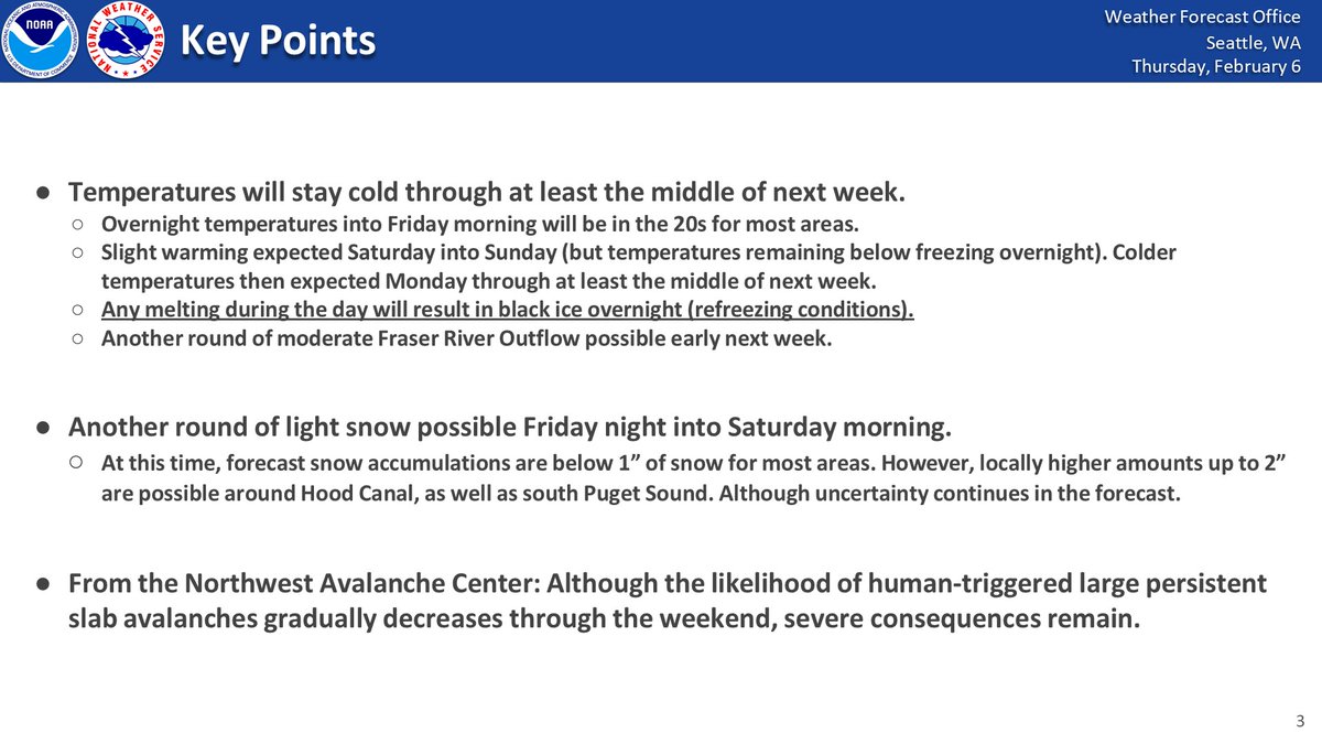
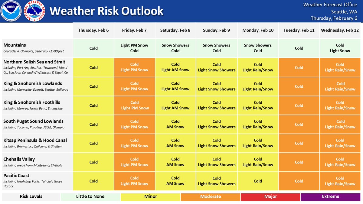
❄️Tonight into Saturday morning: light snow, possibly mixed with rain. Minimal accumulation in the lowlands (1” or less). Light flurries over the weekend.
🌡Saturday and Sunday mornings: chilly, with lows in the upper 20s to low 30s.🥶Be cautious of black ice forming overnight.
🌡️Overnight temperatures tonight into Friday morning dip into the 20s. It will remain chilly through at least the middle of next week. 🥶 Any melting snow will result in black ice overnight. Another light round of snow possible Friday night into Saturday morning. Stay Safe ❄️
The potential of snow still exists! Grays Harbor could see 1-2" of snow before late tomorrow AM. While some areas might be seeing some rain currently, remember that freezing temps tonight can lead to hazardous road conditions tomorrow. Please be careful as you venture out.
❄️Snow showers (mixing w/ rain this afternoon) will continue at times into Thursday AM. We continue to monitor potential for locally higher snow amounts across portions of Puget Sound tonight, and uncertainty in the forecast remains. Give yourself extra time if traveling. #WAwx