Academic researchers often invent one-off sensors, tools, or techniques that die a quiet death in the corner of a lab after a project. Here’s how we’re trying to be different in transitioning https://t.co/muNpDfcl6o to https://t.co/jMxNbUZkiL: https://t.co/LXgaRORvOd
HURRICANE HQ 🌀☔: Life-threatening flooding continues to batter the Gulf Coast as Potential Tropical Cyclone One’s chances of development loom. Tragically, one drowning death has been confirmed in Texas, and tropical storm alerts remain in effect across parts of the Louisiana coast. Latest:
HURRICANE HQ 🌀: Millions of Americans in Texas are bracing for severe weather as Potential Tropical Cyclone One is expected to bring heavy rain, strong winds, thunderstorms and flooding to the state. Stay tuned to FOX Weather as we track this developing storm.
#Texas#Flooding #Severewx #FOXWeather
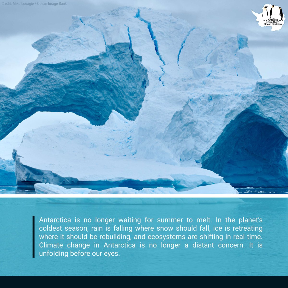
Earlier this month, a record 15.4°C was recorded at Esperanza Station, more than 20°C above average. During winter, Antarctica should be rebuilding ice, stability, and resilience. Instead, that foundation is weakening.
📷 Mike Louagie / Ocean Image Bank
https://t.co/cbmIt0NZnB
Ever since I started on #AMOC stability as a postdoc in 1991, there's been this "cold blob" in sea surface temperature trend since the year 1900. https://t.co/d2yBzvF8Gr
Over ocean it's ERSST data; for winter since that relates most to ocean heat transport (👉Caesar et al 2018).
Atmospheric moisture levels will be *prolific* across the South this week, with the potential for flooding rain spreading across a corridor from Texas to the Carolinas.
In some areas, record-breaking precipitable water of 4 inches is forecast, signaling a waterlogged atmosphere.
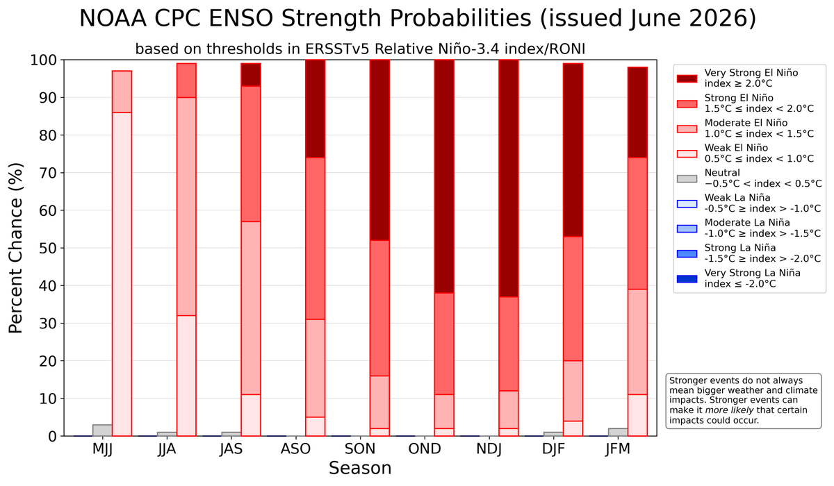
El Niño development is firing on all cylinders.
Sea temperatures in the central equatorial Pacific have now broken records for five days in a row.
A locally record-breaking westerly wind burst is currently causing yet more warming there.
El Niño conditions are present and expected to strengthen into the Northern Hemisphere winter 2026-27. An #ElNino Advisory is now in effect. #ENSO https://t.co/5zlzaZ1aZx
🌀EXCLUSIVE ANALYSIS: FOX Weather Hurricane Specialist Bryan Norcross explains why forecasters at Colorado State University are predicting that a strong El Niño will suppress this hurricane season even more than initially expected. Bryan also analyzes the likelihood of tropical development in the Gulf next week. Watch:
🔵 There's no question that the North Atlantic cold blob, linked to AMOC, has become more persistent in recent decades 🔵
The current cold blob has remained for about a year, coinciding with a negative AMO, which is associated with less northward heat transport in the Atlantic.
🌀HURRICANE HQ: The National Hurricane Center (NHC) has designated the first area to watch for tropical development of the 2026 Atlantic hurricane season. According to the NHC, a broad area of low pressure could form in the Bay of Campeche in the southern part of the Gulf later this week. Latest:
🌧️FLOOD THREAT: Drone video shows floodwaters overtaking parts of Hollytree, Alabama, during a Flash Flood Emergency Sunday afternoon. The flood threat redevelops over parts of northern Alabama, as well as the Tennessee and Ohio valleys, today. Watch FOX Weather for the latest storm coverage:
A record-breaking 3.4˚C El Niño is predicted by the new NMME, which is a collection of six different models.
This forecast is 0.3˚C higher than last month, as the underlying models have captured warming that has already occurred and new heat-shifting westerly wind bursts.
El Niño typically has a warming effect on global temperatures, with the strongest influence often felt in the year after it develops.
It typically brings wetter conditions to some regions and drought to others, though effects vary around the world.
More 👉 https://t.co/jMd3hGUX7x
🚨 BREAKING NEWS: As the Eastern Pacific hurricane season continues its active start, a new Tropical Storm has formed in the basin. Tropical Storm Cristina is the newest named system forming near Central America. Stay with FOX Weather for the latest:
As the sun rises over the eastern Pacific this morning, @NOAA's #GOESEast (#GOES19) 🛰️ is monitoring #TropicalStormBoris off the coast of the Mexican state of Guerrero. #Boris is expected to bring strong winds and heavy rainfall, with dangerous flooding and mudslides possible in coastal areas. It is expected to be the first named storm of the 2026 hurricane season to move inland.
Latest: https://t.co/g8o6QiSK83
TROPICS UPDATE ‼️: Tropical Depression Three-E has formed in the Eastern Pacific and is expected to strengthen into Tropical Storm Cristina by Tuesday. The system could bring several days of heavy rain to parts of Central America and southern Mexico this week. Check out the latest maps highlighting this new development:
FLOOD EMERGENCY 🚨: Torrential storms dumping up to 4 inches of rain per hour are battering Missouri and Kansas this morning. Life-threatening flooding is actively unfolding, with multiple homes inundated and ongoing water rescues underway. Over half the region is currently under a Flash Flood Warning. Latest: