Ab sofort bietet unser Dienst “WMS Begrenzungen im Straßenverkehr” umfassende Informationen zu Geschwindigkeitsbegrenzungen – für alle Straßenkategorien: Autobahnen, Landstraßen oder innerorts. Mehr Infos unter:
https://t.co/ECuIimYykA
#Geodäsie#Verkehr#Datenintegration#BKG
Northern lights over Kewanna, IN! A rare sight in Indiana skies, lighting up the horizon not once but three times in one week. The colors were stunning—visible to the eye, with long exposure capturing even more of the glow.
📷 tomjonesfoto
#CLAAS#LEXION
This data visualisation, based on @CopernicusEMS data, depicts the situation in the ‘Horta Sud’ Area of Interest in Community of Valencia (a small part of a larger monitoring effort being conducted by CEMS) on 31 October at 10:22 UTC.
https://t.co/9GQamgPN2m
Deutschland auf Platz 1 bei den #Investments in #SpaceStartups 🚀. Der Report „Space Venture Europe“ des Instituts @ESPIspace zeigt: Die Investitionen sind im Jahr 2023 um 127 Prozent gestiegen 📈, von 120 auf 273 Millionen Euro. Und 🇩🇪 damit von Platz 3 auf Platz 1 💪.
Link zum Report: https://t.co/l7dvbYkMLl
Abbildung: European Space Policy Institute (ESPI), "ESPI Report Space Venture Europe 2023"
Direct seeding tests with the Avatar
Together with the LFULG Saxony, we sow various catch crops directly into rapeseed stubble.
➡️ In September: Wheat seeding - without prior tillage
Focus of the study: Erosion protection & sustainable management of arable land
Had to think of this fun dataviz again. It shows the distribution of letters towards the beginning, middle or end of words in the English language. Pure #linguistics fun! Source: https://t.co/aLskP6hipg
Today is #DesertificationAndDroughtDay
Recently, droughts affected nearly all 🇪🇺 regions, and are expected to worsen in the coming decades
More more about how they impact agriculture and other sectors in the @EU_ScienceHub European Drought Risk Atlas 👇
#WaterWiseEToday is #DesertificationAndDroughtDay
Recently, droughts affected nearly all 🇪🇺 regions, and are expected to worsen in the coming decades
More more about how they impact agriculture and other sectors in the @EU_ScienceHub European Drought Risk Atlas 👇
#WaterWiseEToday is #DesertificationAndDroughtDay
Recently, droughts affected nearly all 🇪🇺 regions, and are expected to worsen in the coming decades
More more about how they impact agriculture and other sectors in the @EU_ScienceHub European Drought Risk Atlas 👇
#WaterWiseEToday is #DesertificationAndDroughtDay
Recently, droughts affected nearly all 🇪🇺 regions, and are expected to worsen in the coming decades
More more about how they impact agriculture and other sectors in the @EU_ScienceHub European Drought Risk Atlas 👇
#WaterWiseEU
🚨 Last call to register for our #webinar tomorrow!
@StefanLivens and @J_decloedt will explain how to produce cloudless time series with #satellite data and #CropSAR for more accurate crop monitoring.
🗓️ 18 June
⌚ 16:00 CEST
🔗 https://t.co/bHZ3xHwc7g
#DesertificationAndDroughtDay
Last year, we released the European #Drought 🚱 Risk Atlas
It details the impact of drought hazards, exposure, & vulnerability on sectors such as agricultural systems, highlighting how these risks may evolve under projected climate conditions 🌍
It is the #DesertificationandDroughtDay. Land Degradation affects8⃣4⃣% of EU 🇪🇺agricultural soils. Soil degradation affects 6⃣2⃣% of all EU soils. Let’s safeguard soil🏝️ & water 🚰.They ensure food🥘🍲 & fibre for future generation.
https://t.co/hXDSzV6a5O https://t.co/7reqNKmuYY
#OTD in 2013, #NASA declared that the on-orbit checkout for the #LandsatDataContinuityMission was complete. The satellite was transferred to the #USGS and renamed #Landsat8. Today, there are nearly 3 million Landsat 8 Level-1 products. Learn more here: https://t.co/QiSijAMxEx
This chart is dressed up as a map and shows when Egypt was ruled by Egyptians throughout its long history. Most of the time it was ruled by outsiders. Source: https://t.co/Klq7AoqCge
❗️ Until sunday, you can register for the free #AI#networking event "From Distributed Data to Large AI Models" by @SachsenDe & @Sca_DS. Interesing keynotes, a world café & various networking opportunities are only a few of the highlights of the event!
👉 https://t.co/KZsFCUM7F1
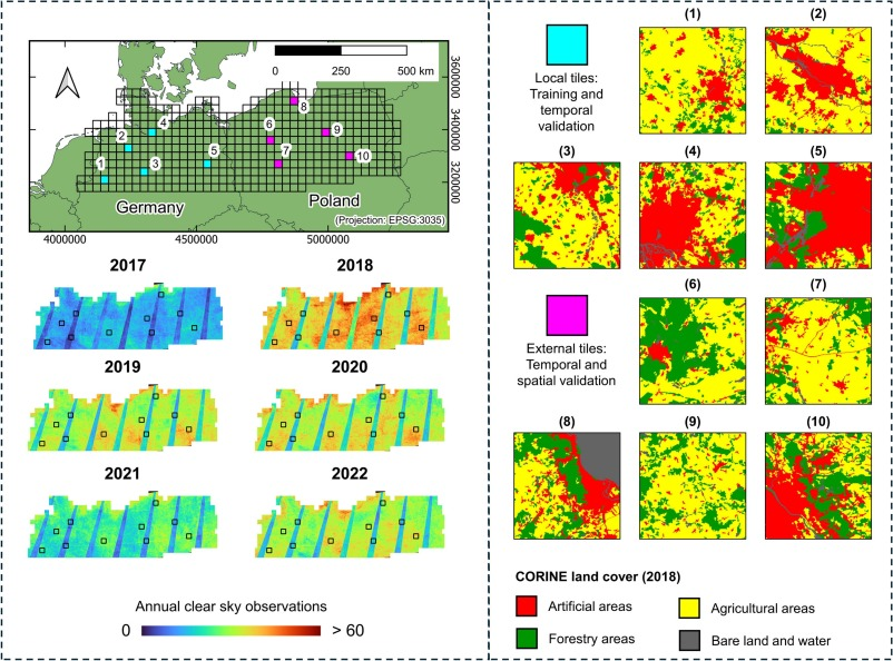
"Specifically, models trained in years with high data density performed well in that same year but poorly when transferred to years with lower density."
Pham et al. Learning the variations in annual spectral-temporal metrics to enhance the transferability of regression models for land cover fraction monitoring. #Sentinel2
https://t.co/yLHWEulRPY