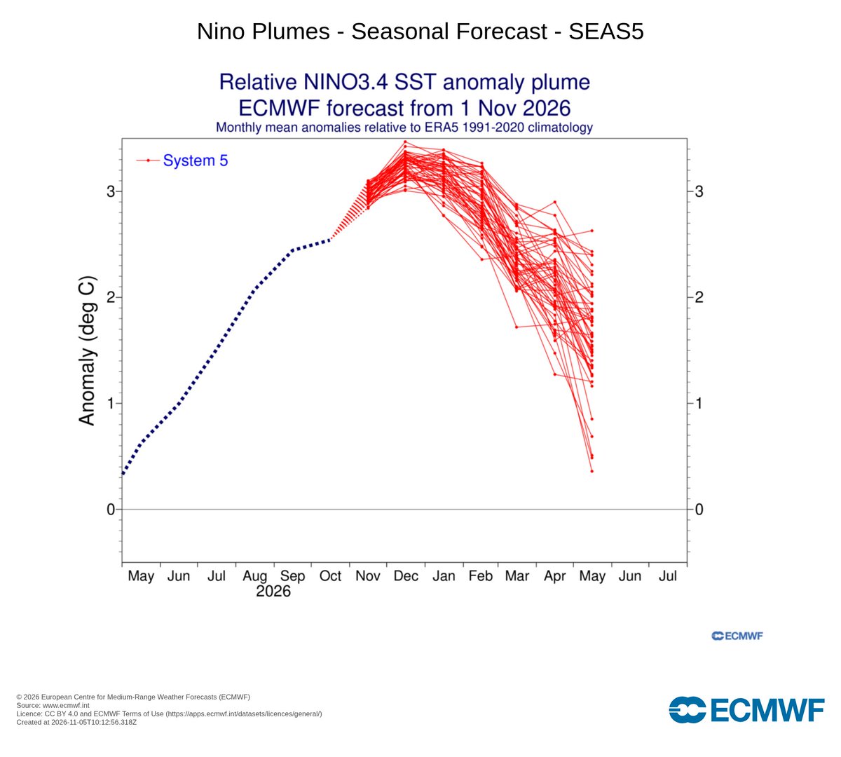
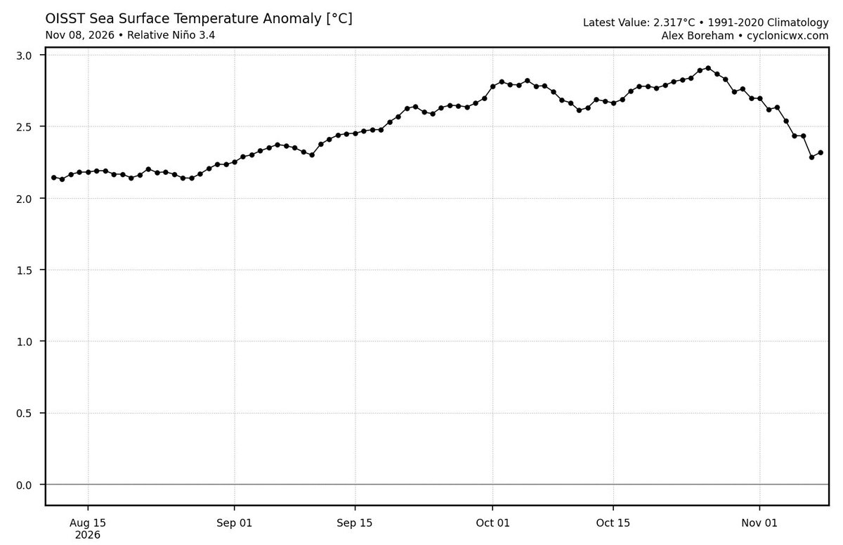
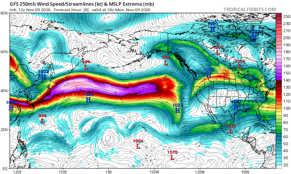
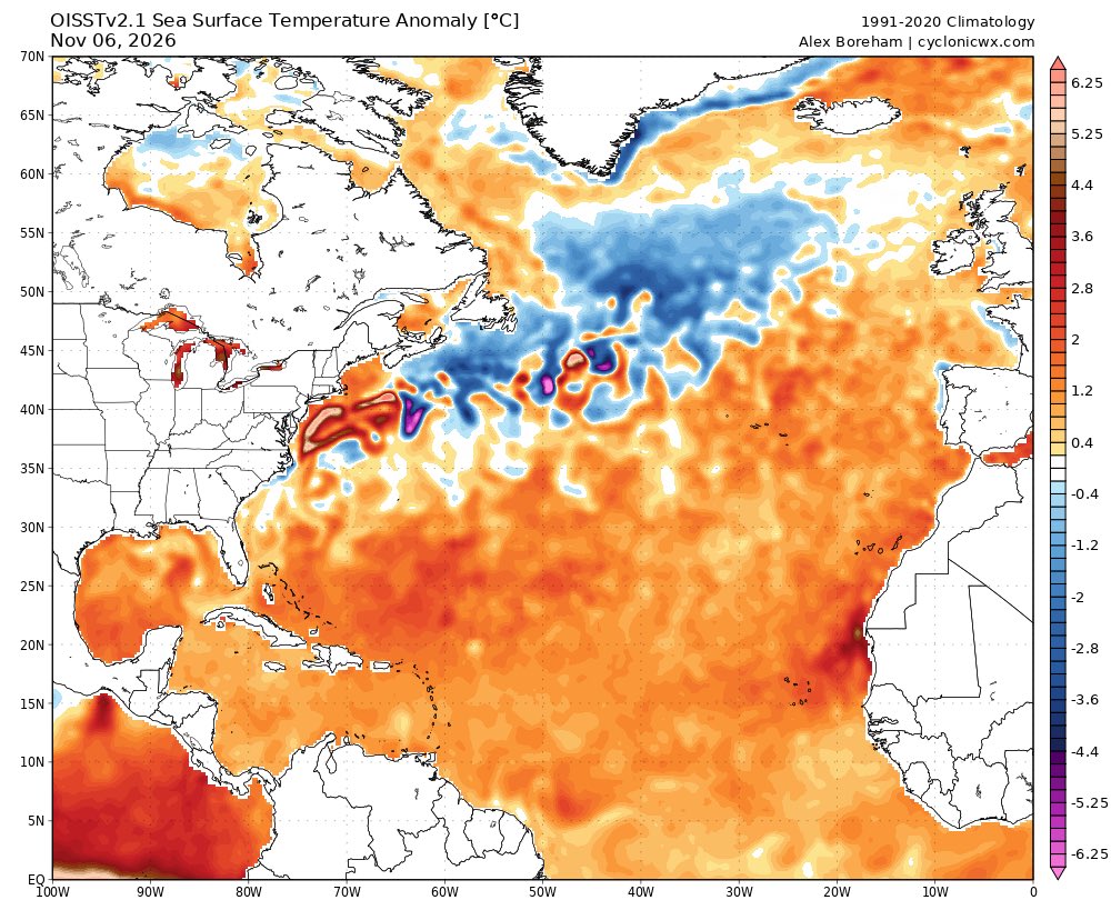
Will be interesting to watch the evolution of this El Niño into 2027. The eastern warmth (shown in the Niño 1+2 region in Ben's post) is pronounced and sticky which may help stifle next hurricane season. But the Atlantic will surely be anomalously warmer and model spread is high.
Pacific tropical cyclone activity in 2026 has been nothing short of exceptional. The hurricane season east of the Date Line shattered its previous ACE record with 358 units, and the western Pacific typhoon season has reached reached about 412 units to date.
That puts the whole North Pacific at roughly 770 ACE so far, which is a new record by this metric.
TV One is saddened to share that actress Irma P. Hall has reportedly passed away at the age of 91. Most known for her role as Big Mama in Soul Food, her talent will live on forever. 🙏🏾🕊️
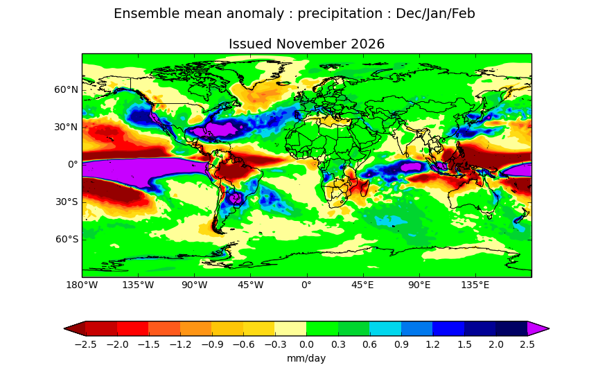
I like how the latest UKMET seasonal shows Florida basically being the wettest (relative to average) spot on earth for the next few months, except for the Equatorial Pacific itself. Pretty classic #ElNiño pattern, and this one may be even more extreme than usual.
November 10, 2022:
Hurricane Nicole made landfall in Florida as a Category 1. The storm was the first hurricane to make landfall on Florida's east coast since Katrina in 2005. Nicole produced significant beach erosion and knocked out power to over 300,000 customers.
#wxhistory
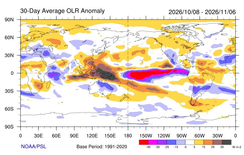
The Tropical West Pacific has warmed anomalously the last month or so
Most of this warming is due to increases in insolation/sunshine from suppressed convection there in the subsiding branch of the anomalous Nino Walker Cell
This is part of the reason why the RONI is falling
A powerful jet interaction with winds exceeding ~200kt in it has resulted in Typhoon #Cempaka undergoing RI with an eye rapidly clearing out and CDO axisymmetrising, helped by a warm eddy of 28C waters underneath. This is almost certainly a major hurricane equivalent TC.
Since my dad died, I wear his high school ring. I never take it off. During Super #Typhoon#HAIYAN, it slipped off my finger while I was rescuing trapped victims. I didn't realize until after the storm. I was at peace with it—decided it was OK because it happened while I was helping people. But hours later, I found the ring in the mud & wreckage—incredibly. Sitting there in the chaos, glimmering in the dull sunshine. I'm not superstitious and I'm not a believer, but this seemed like magic to me—a tiny flash of goodness in the deep blackness of HAIYAN's aftermath. Thirteen years alter, the ring is still on my finger.
On this day in 2013, Super Typhoon Haiyan struck the Philippines as one of the strongest storms ever recorded with winds of 195mph and gusts up to 235mph.
Over 6,000 people were killed. A massive storm surge of 10-20+ feet was mostly to blame for the catastrophic loss of life.
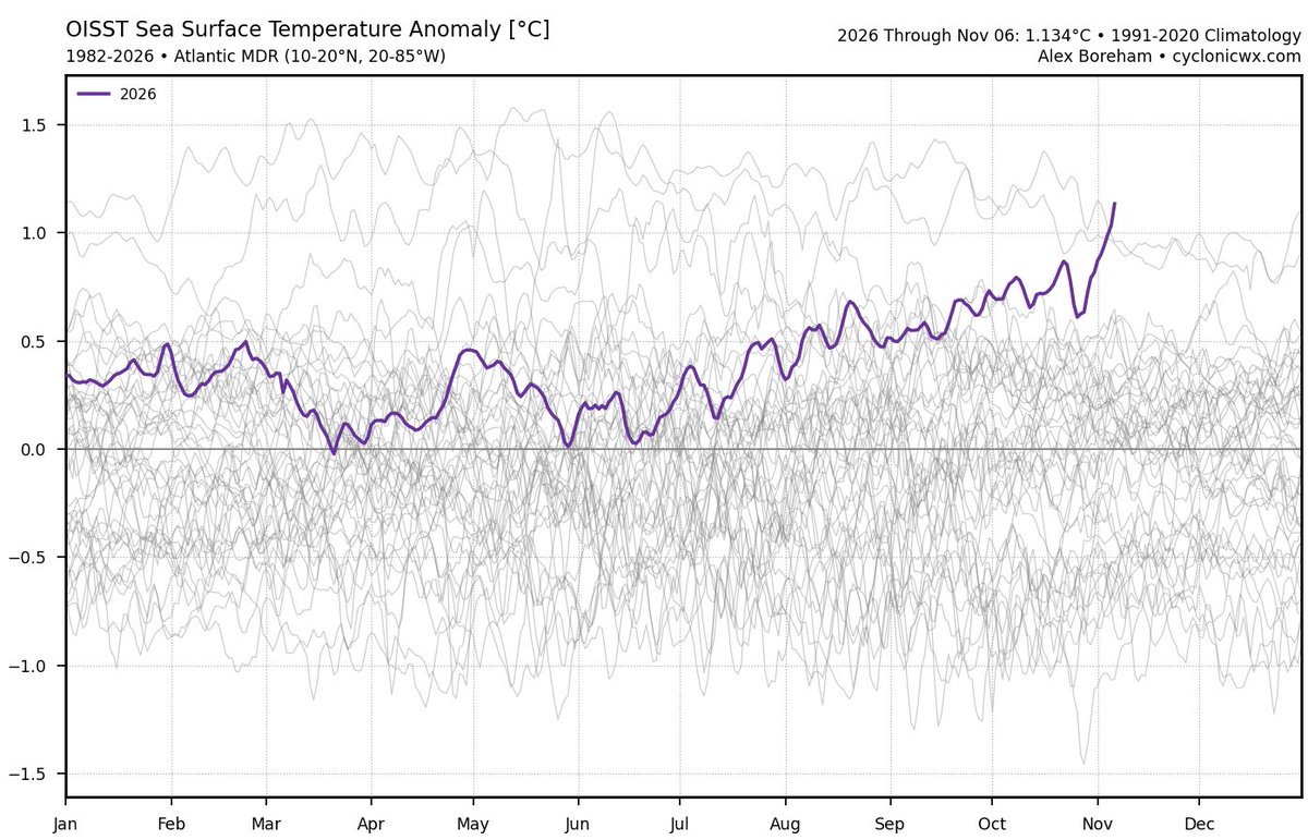
It will be interesting to see if the warming trend across the Atlantic MDR continues through the winter
This could be setting up for a very active 2027 season
November 7-8, 2013:
Typhoon Haiyan peaked as a 195 mph, 895 millibar Category 5-equivalent super typhoon. The storm is one of the strongest tropical cyclones ever recorded based on wind speed and is also one of the strongest landfalling tropical cyclones on record.
#wxhistory
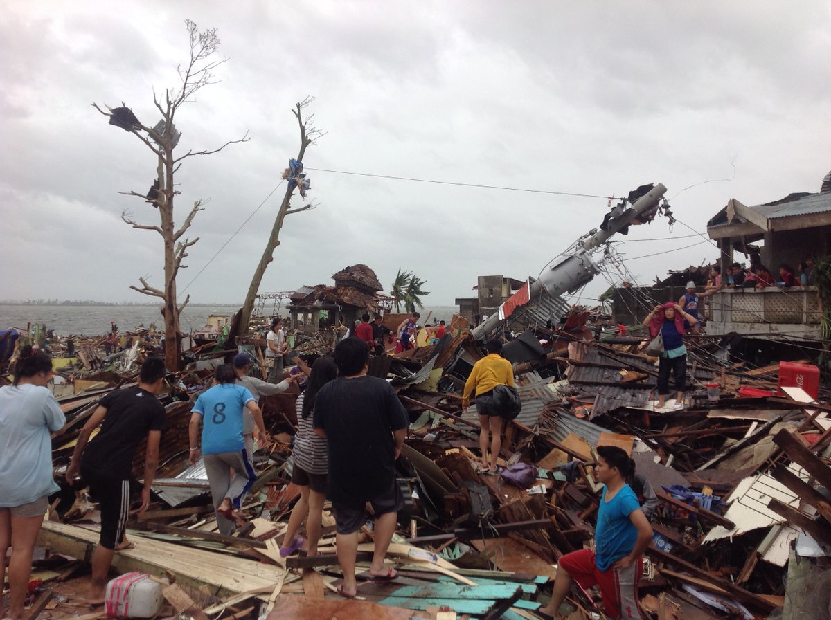
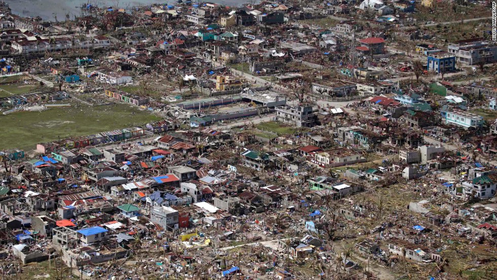
Today (08 Nov) marks 13 years since one of the greatest catastrophes of the 21st century: Category 5 Super #Typhoon#HAIYAN in the #Philippines—known locally as YOLANDA.
This fast-moving, *extremely* intense storm came roaring ashore on the island of Leyte just after dawn with jaw-dropping ferocity—one of the most intense cyclone landfalls ever observed. And although it was small, HAIYAN aimed perfectly, with its potent right eyewall nailing the large, low-lying city of Tacloban.
As the typhoon's center passed just south of the city, the winds shifted direction, forcing a tremendous volume of water into tiny San Pablo Bay—too much water. It overflowed into waterfront neighborhoods in a great, tsunami-like surge, engulfing almost the entire city in a matter of minutes. Unable to react quickly enough, many thousands of people perished. Yes, thousands.
I was there and I'll never forget it: first the wolf-like howl of the winds raking the city streets... then the crashing of windows breaking and doors tearing off... then the rushing of water invading the hotel from above and below... and then the screams. People in danger—trapped in their rooms as the surge rapidly swallowed up the first floor.
I remember having a sick feeling—that I was going to watch people die. Right in front of me. I needed to do something—anything. I threw my camera down and jumped into that black, horrible water. Working with my chase partners, Mark Thomas and James Reynolds (@EarthUncutTV), and a few other fellows, we somehow managed to pull everyone out of their flooded rooms—through the windows—and get them up to the second floor. I'm proud to say no one in our hotel died, although there were injuries—the most serious being Mark's. While performing rescues, he gashed his leg open—an injury so serious doctors had to fight to save his leg days later in Taiwan. (Someone was watching over me, because despite swimming in that same treacherous water wearing nothing but athletic shorts and a tank top, I had only a few scratches.) (Thanks to James for this shot of me rescuing a victim—it's from his incredible video of this event.)
The aftermath of the typhoon was so horrid it almost drove me to retire from stormchasing. Dead bodies everywhere. Injured children. Whole neighborhoods erased. A scale of misery that I couldn't comprehend. I remember shutting off my emotions—just going ice cold—because I knew if I let myself feel anything at all, I would not be able to function. A week later, when I was safely home and had the luxury to feel again, there were many tears.
HAIYAN was life-changing. It brought me face to face—in a raw, harsh way—with the ugly side of something I'd always seen as spectacular natural wonder. The urge to chase came back—but very slowly.
I've been back to Tacloban City several times since the catastrophe: a couple of months after, a year after, and ten years after. The city occupies a special place in my heart—like a home on the other side of the planet. Seeing Tacloban heal so remarkably—and reconnecting with fellow survivors of the storm—has been healing for me. ❤️
13 years ago today, one of the most beautiful yet haunting satellite images in history. Super Typhoon Haiyan reached peak intensity before its catastrophic impact to the Philippines. Pressure got down to 885mb with winds of 195mph & gusts to up to 240mph.
13 years ago today, 195 MPH Super Typhoon Haiyan (Yolanda) brought terror to the Philippines.
One of the strongest landfalling storms that’s ever been recorded anywhere on Earth.
At exactly this hour 13 years ago, the incredible Super #Typhoon#HAIYAN was rapidly closing in on the #Philippines. One of the most extreme specimens ever observed, it was barreling W with estimated winds of 170 knots. I was in Tacloban City (star) waiting for it. I remember in those predawn hours, the city was calm, quiet, serene. Three hours later, an atmospheric nuclear bomb killed thousands of people & left the city almost unrecognizable.