

Top Tweets for #92c

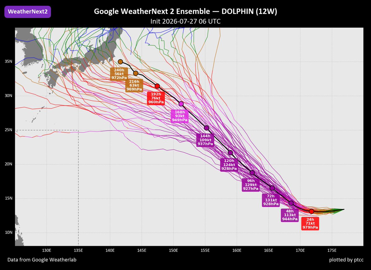
TS #DOLPHIN (#12W, former #92C) has strengthened after crossing the Date Line... Satellite imagery reveals a consolidating system with tight bands around the LLCC... Aided by robust outflow... DOLPHIN is expected to become a major TY in the next few days...
Mid-range model guidance continues to suggest a potential approach towards #Japan in early August...


JUST IN: The Joint Typhoon Warning Center (JTWC) has released its first tropical cyclone advisory for Tropical Depression #92C, located northeast of the Marshall Islands.
The JTWC forecasts the system to intensify into a Category 4 super typhoon by Saturday, August 1, with 1-min sustained winds of 135 kts (~250 km/h). Likewise, the Japan Meteorological Agency (JMA) expects the system to become Tropical Storm #Dolphin within the next 12 hours.
Most forecast models continue to indicate that 92C could reach a central pressure equivalent to that of a Category 5 super typhoon sometime between this weekend and early next week.
The system poses no threat to any landmass over the next seven days.
📷: Himawari-9 via Dapiya, JTWC


Unofficial #HCCTWO
(1) #Genevieve nearly a Category 5
(2) #Fausto headed towards #Hawaii
(3) #92C forms, likely to become a #supertyphoon
(4) #93B to deliver Moderate Impacts to #India
(5) #Noul now a RL over #China
#wx #hurricane #typhoon #cyclone


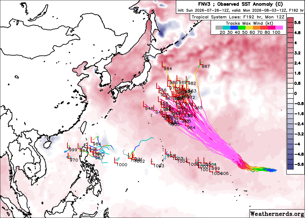
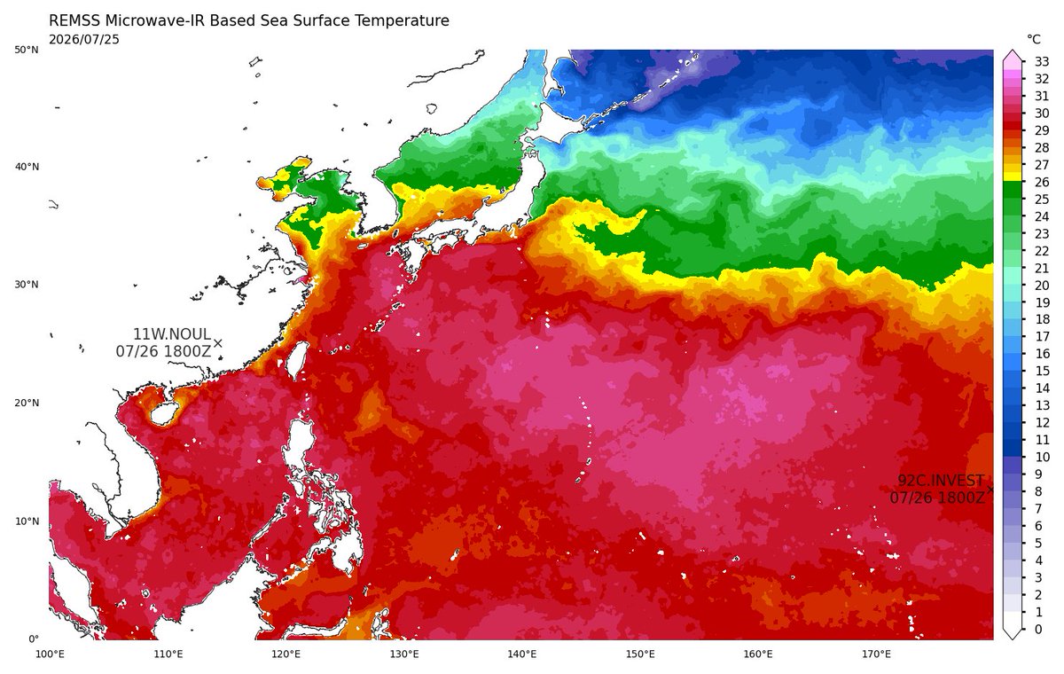
#92C looks to have developed now with the help of a very strong WWB. It will traverse much of the West Pacific, including the patch of record SSTs, and most likely end up a powerful typhoon


Meanwhile, Invest #92C in the Central Pacific (soon to cross into the Western Pacific) should become extremely intense in its own right, embedded within a highly favorable environment for several days.
All this is in line with the record-breaking El Nino we're watching develop.

BREAKING: Invest 92C has crossed the International Date Line, entering the Western Pacific (WPAC), where it has been upgraded into a tropical depression by the Japan Meteorological Agency (JMA).
The JMA has also issued its first tropical cyclone advisory for TD #92C, which is expected to strengthen into a tropical storm within the next 24 hours. Once it reaches tropical storm intensity, it will be assigned the international name #Dolphin.
Note: Based on its current projected track, the system is not expected to enter the Philippine Area of Responsibility (PAR).
An exceptionally favorable environment, characterized by robust outflow in all quadrants, very warm sea-surface temperatures (SSTs), and high ocean heat content (OHC), is expected to trigger a phase of rapid intensification (RI) over the next 72 hours. The SHIPS forecast indicates an 85% probability of a 55-kt (100 km/h) increase in 1-min winds (US scale) within just 48 hours — approximately 14.4 times higher than the climatological average.
Meanwhile, the Joint Typhoon Warning Center (JTWC) continues to assess the system as an area of low pressure (Invest), but with a HIGH chance of tropical cyclone development within the next 24 hours, and has already issued a Tropical Cyclone Formation Alert (TCFA).
Current model guidance indicates that TD 92C may reach super typhoon intensity (US scale; JTWC) as it meanders across the west-central Pacific Ocean, with no threat to any landmass for at least the next seven days.
📷: Himawari-9 via RAMMB-CIRA, JMA, Dapiya


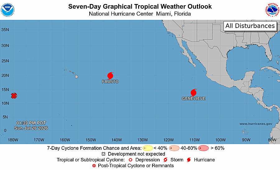
#FAUSTO; 85mph 984mb
Remains a hurricane as it draws near to Hawaii,
#GENEVIEVE; 140mph 947mb
Rapidly intensifying hurricane continues to strengthen, the 1st major of the 2026 EPAC season.
#92C; 90/90- A depression will likely form in the WPAC by tonight or tomorrow.
#wxtwitter



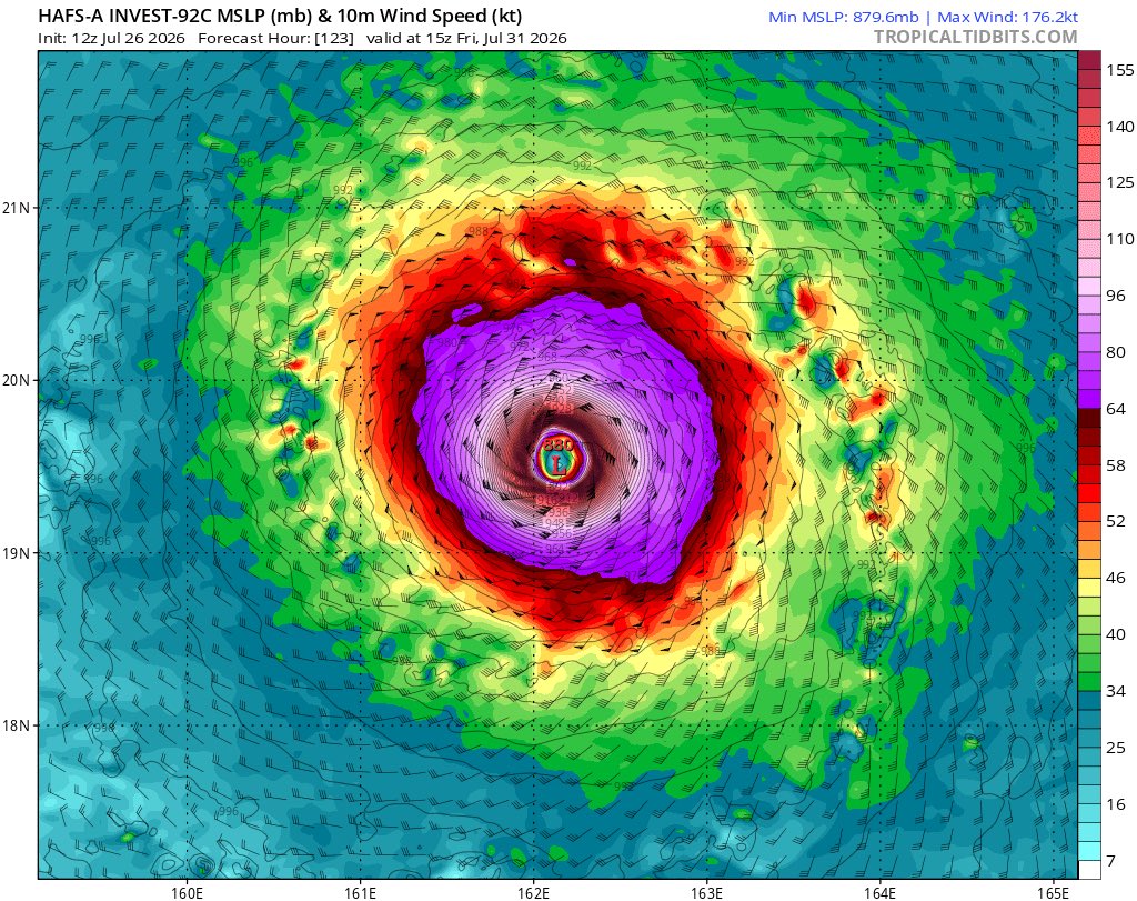
Invest #92C has quite sky high potential over the next few days. Most of the intensity guidance is in the very least making this a Category 4 strength storm, but I think we might have another monster WPac storm in the making. The HAFS certainly agree with me LOL...
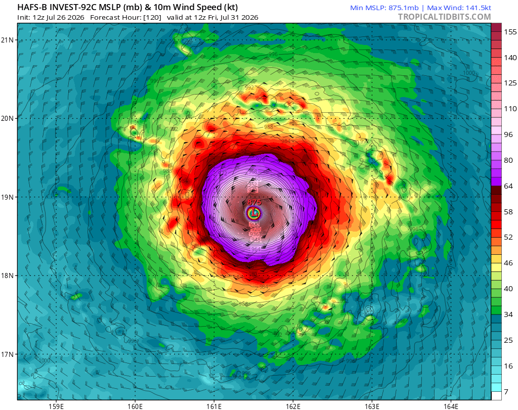
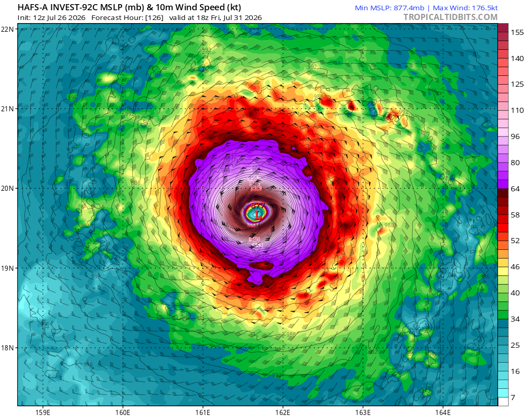
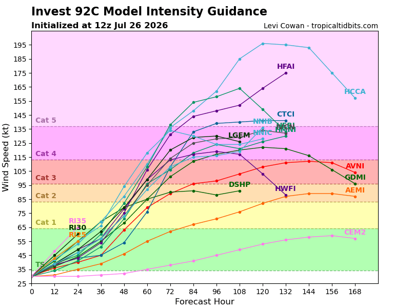

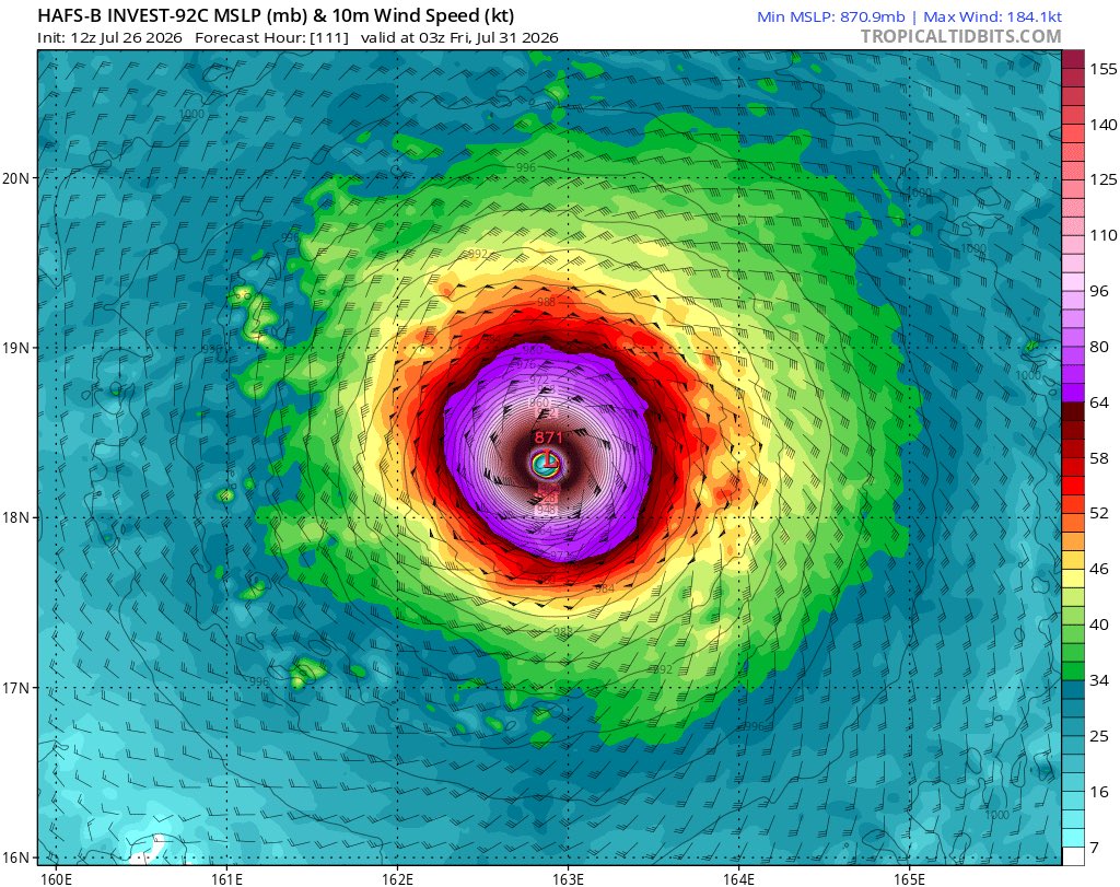
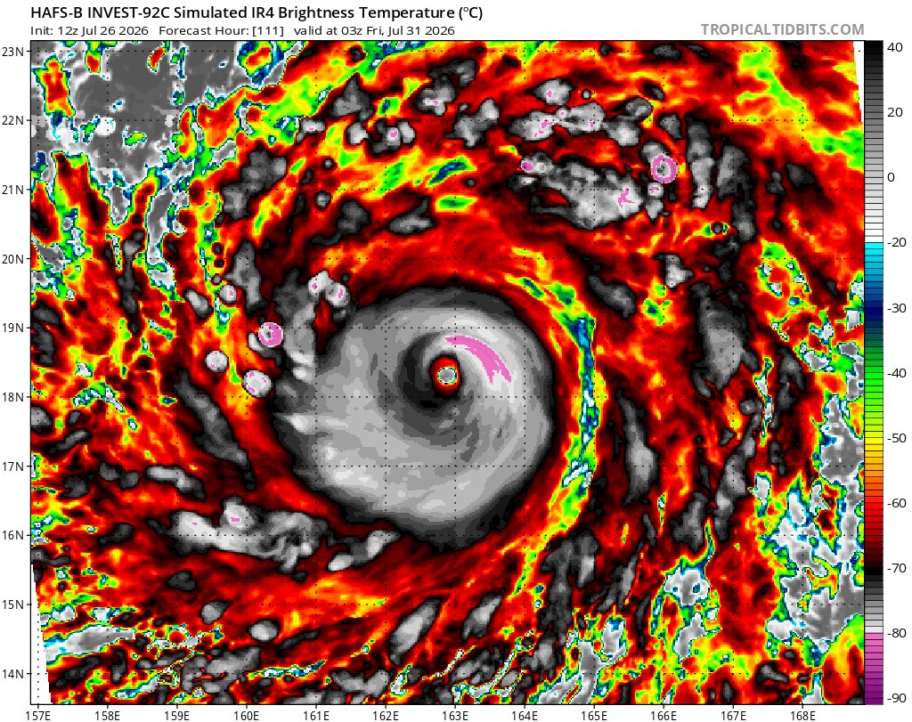
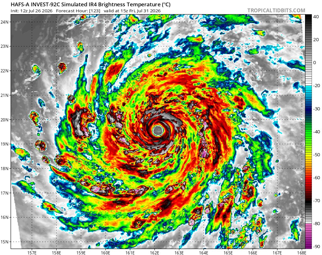
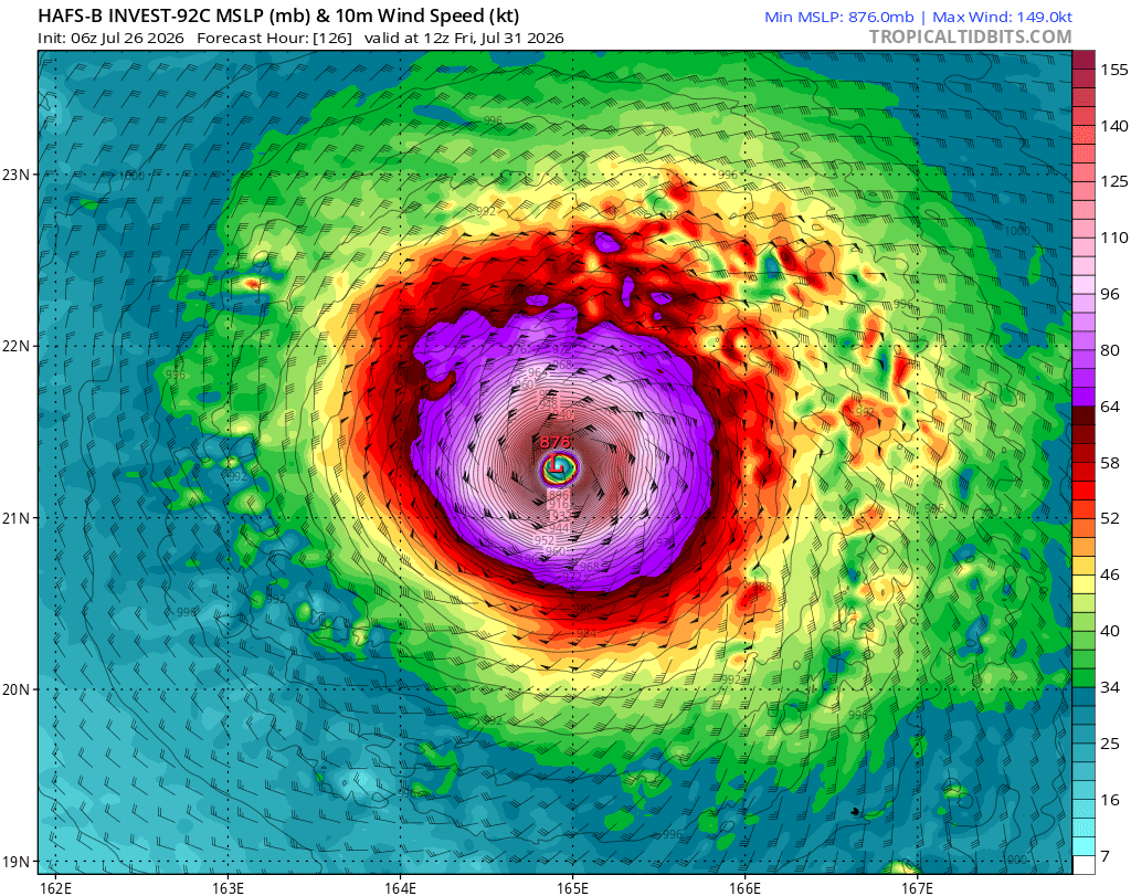
We got a hall of fame run from both HAFS-A and B models for 12Z in #92C. The show it reaching 175-185 kts (200-215 mph) with a pressure of 871-885 mbar. I believe the max peak is 150-170 kts (175-195 mph). These environment in the eastern #WPAC is very ripe. #wxtwitter #wx
#93B; Medium formation chance in the next 48 hours.
#92C; High formation chance in the next 48 hours, TCFA issued per the JTWC. Models have been showing this could be a big one...
#wxtwitter


#92C remains on track to be a strong, long-lasting WPAC typhoon. Shear will remain light with uniform prevailing southeasterlies and multiple outflow channels (esp to the NE). Steady strengthening is expected the next couple of days before explosive deepening ~18z/Tue - 00z/Thu


#92C is very close, if not, already a TC as we can see low-lvl rotation, especially w/ the W-erly winds present. It’s very close to the IDL so it may get designated in the WPac. Should it be named in the CPac, #Lala is the next name, otherwise it’s #Dolphin.
#tropicswx

É literalmente um monstro nascendo. Assim como Genevieve, #92C tem divergência em praticamente todos os lados, o que mostra que o cisalhamento de vento na área é baixíssimo. É uma situação típica de El Niño, um poderoso ciclone tropical começando a se formar no meio do Pacífico.
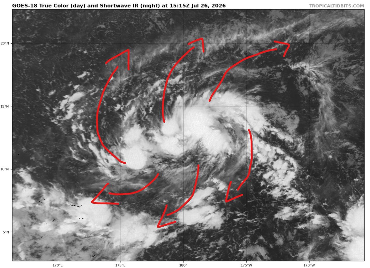
Uma área de baixa pressão localizada na linha internacional de data tem chamado não somente a minha, mas a atenção de muita gente pelo seu potencial de se tornar um tufão muito poderoso no Pacífico Oeste nos próximos dias. A área é designada como Invest #92C.
The latest HAFS models are suggesting Invest #92C could become one of the strongest #supertyphoon in history across the globe! The lowest pressure recorded was #Typhoon Tip at 870, and it is showing 92C could reach 876mb!


Weakening Hurricane #Fausto has now entered the central Pacific Ocean while continuing to move westward towards the Hawaiian islands and Invest #92C has a 90% chance to develop into a Tropical Depression in the next 2 days and a 90% chance in the next 7 days as a Depression is likely to form as it crosses into the western Pacific Ocean #tropicalupdate #tropicswx #hurricane #wxtwitter #severewx #wind #rainfall #BREAKING #hawaii


Last Seen Hashtags on Sotwe
rr34 #scat
Seen from Poland
bursagay
Seen from Turkey
straightbait
Seen from United States
minichat()** filter:videos
Seen from Switzerland
unexpected()******filter:videos
matrimonioaprimavista
Seen from Italy
amatör sex
Seen from Turkey
minichatt
Seen from United States
CaughtOnCamera
Seen from Turkey
nolimitt
Seen from United Kingdom
Most Popular Users

Elon Musk 
@elonmusk
241.5M followers

Barack Obama
@barackobama
118.8M followers

Cristiano Ronaldo
@cristiano
114.5M followers

Donald J. Trump
@realdonaldtrump
111.8M followers

Narendra Modi
@narendramodi
107.1M followers

Rihanna
@rihanna
98.7M followers

NASA
@nasa
92.3M followers

Justin Bieber
@justinbieber
91.8M followers

KATY PERRY
@katyperry
90M followers

Taylor Swift
@taylorswift13
84M followers

Lady Gaga
@ladygaga
75.5M followers

Virat Kohli
@imvkohli
73.5M followers

Kim Kardashian
@kimkardashian
70.9M followers

YouTube
@youtube
68.8M followers

Neymar Jr
@neymarjr
66.5M followers

Bill Gates
@billgates
65.3M followers

Selena Gomez
@selenagomez
63.1M followers

The Ellen Show
@theellenshow
62.2M followers

CNN
@cnn
61.7M followers

X
@x
60.7M followers