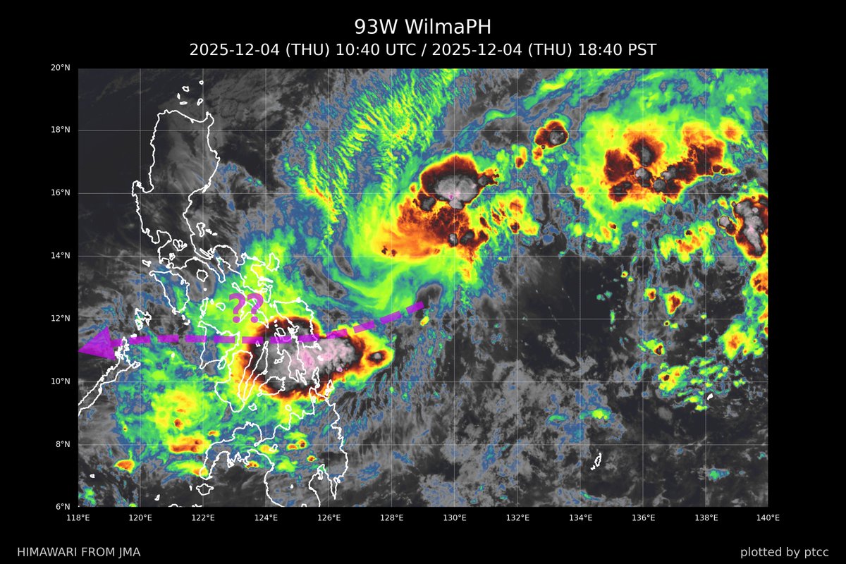
#93W (PAGASA TD #WilmaPH) is moving closer to #EasternVisayas...
Satellite animation indicates that the convection is being sheared... leaving the LLCC exposed to the south... An ASCAT scan in the morning showed strong northeasterly winds in the NW quadrant due to NE monsoon... while winds near the weak and elongated LLCC were mostly below 25 kt...
We expect WilmaPH to remain weak over the next couple of days as it moves across central #Philippines...
WilmaPH is likely to move W/WSW... approaching Samar and Leyte later tomorrow or early Saturday... It will then cross the #Visayas and #Mimaropa on Sunday and Monday...
Although wind threat is relatively low... Heavy rains are expected in the Visayas... Some areas may receive over 300 mm of rainfall... Please stay alert...
The vortex (#SENYAR, #04B) we mentioned yesterday made landfall just south of #KLIA, #Malaysia before midnight... KLIA reported gusts of 65 km/h or 35 kt...
The system moved across the #Malay Peninsula and emerged over the South China Sea near #Terengganu and #Pahang... It is expected to move NE towards the #Spratly Islands... While slight intensification is possible... environmental conditions do not support significant strengthening... It is likely to remain a TD or briefly reach TS intensity tomorrow...
#KualaTerengganu received over 350 mm of rainfall in the past 24 hours... Other stations such as KLIA on the west coast and #Kuantan on the east also recorded more than 100 mm of rainfall...
Unsettled weather will persist in Terengganu overnight... As SENYAR moves further away... Weather conditions will improve tomorrow...
[At 2.5°N?!]
Radar images from Malaysia indicate a vortex moving towards the coast of southern #Selangor and northern #NegeriSembilan of #Malaysia... near #KLIA...
Residents near these regions are advised to remain vigilant... Heavy rains and strong gusts can be expected in the coming hours as the vortex moves onshore...
The adverse weather associated with #SENYAR (#04B) or its remnants will continue to bring heavy rains onto the #Malay Peninsula tonight and tomorrow... Weather conditions are expected to improve on Saturday...
(Radar image from MetMalaysia)
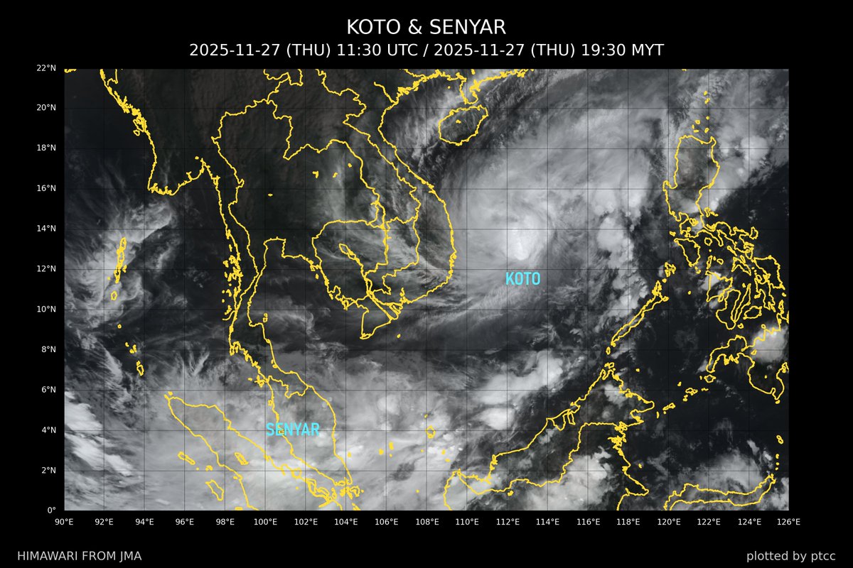
(1) #KOTO (#33W, #VerbenaPH) has become a TY over the South China Sea...
Without a strong steering ridge, a deep upper-level trough, or an intense northeast monsoon... KOTO is expected to meander slowly over the waters east of #Vietnam for the next 3 to 4 days... Its intensity is projected to decrease gradually due to declining SSTs and moderate to strong wind shear...
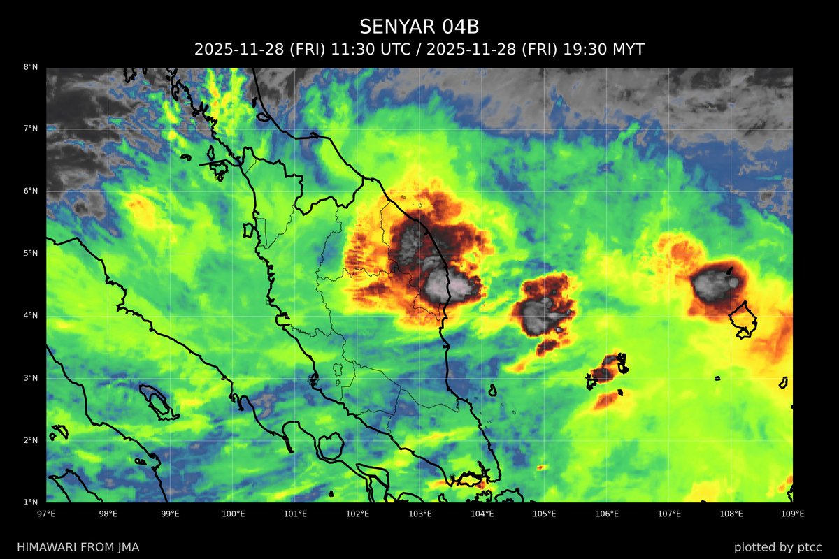
(2) #SENYAR (#04B) has weakened into a TD near #Sumatra... and it has moved eastward back to #Malay Peninsula...
Heavy rains will continue in the Peninsula tonight and tomorrow until SENYAR (its remnants) progresses further east into the South China Sea later tomorrow and on Saturday... Residents living in this part of #Malaysia are advised to stay vigilant...
[As rare as volcanic ash over Tibet] An unusual TC (named #SENYAR, #04B) developed over the Strait of Malacca in the early morning and made landfall in #Ache Province of #Indonesia...
It is expected to weaken over northern #Sumatra tonight... There is a possibility that SENYAR may move eastward across the Strait again towards #Malaysia...
Residents in northern #Sumatra are advised to stay alert as heavy rains will continue to affect the region tonight and tomorrow... Friends in the #Malay Peninsula should also prepare for potential heavy rains on Friday...
Does anyone remember #VAMEI in 2001?
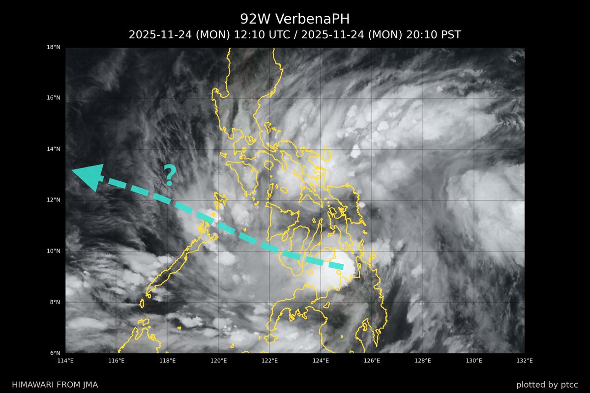
TD #92W, or #VerbenaPH, has crossed #Caraga and is moving over the #Bohol Sea...
VerbenaPH did not have sufficient time to strengthen before making landfall this afternoon... The LLCC isn't well organised at this moment ... There is a small area of deep convection near the centre... while more significant convective activity is mainly occurring to the north where northeasterlies and southeasterlies converge...
The system is expected to stay weak as a TD overnight and early tomorrow... It will cross #CentralVisayas and #Negros during the night... and reach the northern end of #Palawan tomorrow...
It could strengthen into a weak TS over the Sulu Sea... or more likely after it leaves #Mimaropa...
Residents in the #Visayas, Mimaropa and southern parts of #Luzon are advised to watch out for potential heavy showers tonight and tomorrow...
TD #FUNGWONG transitioned into an extratropical system after crossing southern#Taiwan... As the frontal system passed over #Yaeyama Islands... #Yonagoni Airport recorded gusts up to 63 kt or 116 km/h due to the tight pressure gradient assoicated with the NE monsoon...
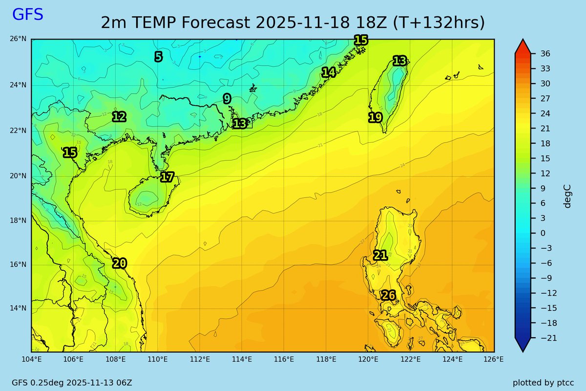
No Tropical Storm is expected to develop in the West Pacific over the next 7 days...
An intense surge will move down from #China early next week... bringing significant temperature drops and widespread Strong-Gale force northeasterly winds...
Minimal TS #FUNGWONG (#32W, #UwanPH) made landfall in #Pingtung County, #Taiwan before 8 p.m. local time... It then weakened into a TD over #Hengchun Peninsula...
The threats from rain and wind diminished as it lost strength quickly... although heavy showers will affect Hengchun and the eastern part of the island overnight... and also NE Taiwan tomorrow...
The depression is expected to continue towards #Miyakojima as a TD...
(Images from NOAA & CWA)
#FUNGWONG weakened much more faster than expected as it encountered increasingly harsh conditions... The onvection has been sheared to the north... The storm is now a minimal STS and is expected to weaken further into a TS before it makes landfall in #Taiwan...
The sub-tropical ridge quickly extended over the #Philippines after FUNG-WONG departed... The cyclone will move NE and hit southern #Taiwan tomorrow afternoon or evening...
Although FUNG-WONG continues to lose strength... Heavy rains remain possible, especially on the windward side of the Central Mountain Ranges... Rainfall may exceed 250 mm in those areas...
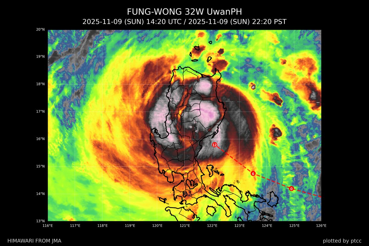
#FUNGWONG (#32W, #UwanPH) has emerged over the seas and has weakened into a TY (JMA STS 🫣)... The current intensity is about 70 kt or 130 km/h (10-min)...
It has one more day to reorganise and reintensify before facing harsh environmental conditions associated with NE monsoon penetrating southward from #China...
FUNG-WONG will move poleward and recurve towards #Taiwan in the next couple of days... Landfall in SW Taiwan is anticipated on Wednesday afternoon... possibly as a STS/TY...
⚠ Significant rainfall is expected... especially to the east of the Central Mountain Range... with over 500 mm of rain possible in regions like #Hualien and #Ilan over the coming days...
(Image from NRL)
#FUNGWONG (#32W, #UwanPH) has moved further northwest after sunset and made landfall in #Dinalungan, #Aurora, according to PAGASA...
FUNG-WONG will weaken back into a TY shortly... It will quickly traverse the landmass of #Luzon and emerge over the sea in the early hours of Monday...

![ptccfeed's tweet photo. [At 2.5°N?!]
Radar images from Malaysia indicate a vortex moving towards the coast of southern #Selangor and northern #NegeriSembilan of #Malaysia... near #KLIA...
Residents near these regions are advised to remain vigilant... Heavy rains and strong gusts can be expected in the coming hours as the vortex moves onshore...
The adverse weather associated with #SENYAR (#04B) or its remnants will continue to bring heavy rains onto the #Malay Peninsula tonight and tomorrow... Weather conditions are expected to improve on Saturday...
(Radar image from MetMalaysia)](https://pbs.twimg.com/media/G6xQgPRbkAAV1pP.png)


![ptccfeed's tweet photo. [At 2.5°N?!]
Radar images from Malaysia indicate a vortex moving towards the coast of southern #Selangor and northern #NegeriSembilan of #Malaysia... near #KLIA...
Residents near these regions are advised to remain vigilant... Heavy rains and strong gusts can be expected in the coming hours as the vortex moves onshore...
The adverse weather associated with #SENYAR (#04B) or its remnants will continue to bring heavy rains onto the #Malay Peninsula tonight and tomorrow... Weather conditions are expected to improve on Saturday...
(Radar image from MetMalaysia)](https://pbs.twimg.com/media/G6xQgPUa0AIH_v-.png)


![ptccfeed's tweet photo. [As rare as volcanic ash over Tibet] An unusual TC (named #SENYAR, #04B) developed over the Strait of Malacca in the early morning and made landfall in #Ache Province of #Indonesia...
It is expected to weaken over northern #Sumatra tonight... There is a possibility that SENYAR may move eastward across the Strait again towards #Malaysia...
Residents in northern #Sumatra are advised to stay alert as heavy rains will continue to affect the region tonight and tomorrow... Friends in the #Malay Peninsula should also prepare for potential heavy rains on Friday...
Does anyone remember #VAMEI in 2001?](https://pbs.twimg.com/media/G6rk7TaacAAFJ4p.jpg)