

Top Tweets for #94b


#94B for record purposes


All set to form a first named cyclone #montha, and is expected to landfall near #andhra coastal districts near #machilipatnam around 28th.
Please be vigilantly and follow the advisory from the official agencies.
#weather #cyclonealert #94B
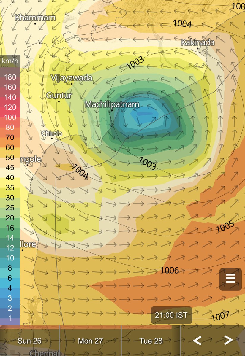
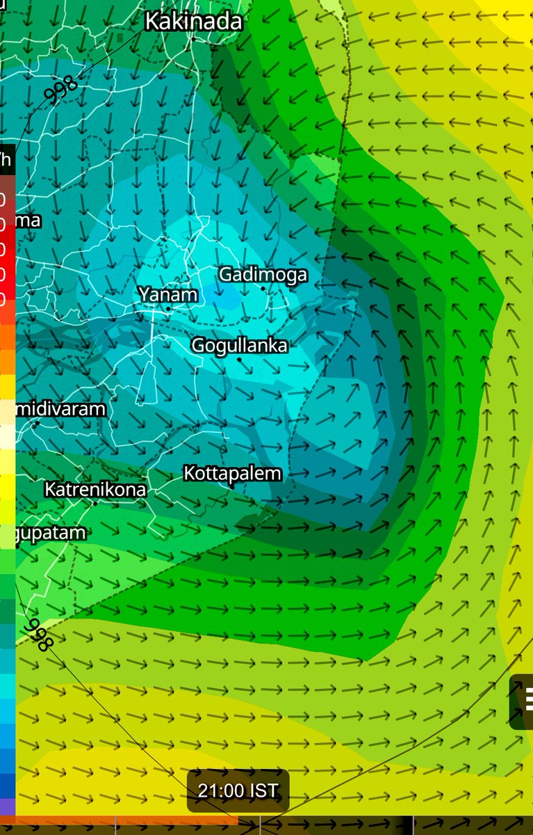
#CycloneMontha possibility of landfall locations #yanam #gogullanka #gadimoga #Kakinada take precautionary measures timings would be late evening or mid night stay safe #AndhraPradesh #94B

(A) #Cyclonic #Storm “#Montha” [Pronunciation : Mon-Tha] over Southwest & adjoining areas of Westcentral and southeast Bay of Bengal
The Cyclonic Storm “Montha” [Pronunciation : Mon-Tha] over Southwest & adjoining southeast Bay of Bengal moved northwestwards with a speed of 15 kmph during past 6 hours and lay centered at 0530 hrs IST of today, the 27th October 2025, over Southwest & adjoining areas of Westcentral and southeast Bay of Bengal, near latitude 12.2°N & longitude 85.3°E, about 560 km east-southeast of Chennai (Tamil Nadu), 620 km south-southeast of Kakinada (Andhra Pradesh), 650 km south-southeast of Visakhapatnam (Andhra Pradesh), 790 km south of Gopalpur (Odisha) and 810 km west of Port Blair (Andaman & Nicobar Islands).
It is likely to continue to move northwestwards over southwest & adjoining westcentral Bay of Bengal during next 12 hours, then north-northwestwards and intensify into a severe cyclonic storm by morning of 28th October. Continuing to move further north-northwestwards, it is very likely to cross Andhra Pradesh coast between Machilipatnam and Kalingapatnam around Kakinada during evening/night of 28th October as a severe cyclonic storm with a maximum sustained wind speed of 90-100 kmph gusting to 110 kmph.
(B) Depression over eastcentral Arabian Sea
The Depression over eastcentral Arabian Sea moved north-northeastwards with a speed of 20 kmph during past 6 hours and lay centered at 0530 hrs IST of today, the 27th October 2025, over the same region, near latitude 16.1°N & longitude 66.8°E, about 720 km west-southwest of Mumbai (Maharashtra), 750 km west of Panjim (Goa), 850 km northwest of Aminidivi (Lakshadweep) and about 940 km west-northwest of Mangalore (Karnataka).
It is likely to move nearly northeastwards across Eastcentral Arabian Sea during next 24 hours.
![Indiametdept's tweet photo. (A) #Cyclonic #Storm “#Montha” [Pronunciation : Mon-Tha] over Southwest & adjoining areas of Westcentral and southeast Bay of Bengal
The Cyclonic Storm “Montha” [Pronunciation : Mon-Tha] over Southwest & adjoining southeast Bay of Bengal moved northwestwards with a speed of 15 kmph during past 6 hours and lay centered at 0530 hrs IST of today, the 27th October 2025, over Southwest & adjoining areas of Westcentral and southeast Bay of Bengal, near latitude 12.2°N & longitude 85.3°E, about 560 km east-southeast of Chennai (Tamil Nadu), 620 km south-southeast of Kakinada (Andhra Pradesh), 650 km south-southeast of Visakhapatnam (Andhra Pradesh), 790 km south of Gopalpur (Odisha) and 810 km west of Port Blair (Andaman & Nicobar Islands).
It is likely to continue to move northwestwards over southwest & adjoining westcentral Bay of Bengal during next 12 hours, then north-northwestwards and intensify into a severe cyclonic storm by morning of 28th October. Continuing to move further north-northwestwards, it is very likely to cross Andhra Pradesh coast between Machilipatnam and Kalingapatnam around Kakinada during evening/night of 28th October as a severe cyclonic storm with a maximum sustained wind speed of 90-100 kmph gusting to 110 kmph.
(B) Depression over eastcentral Arabian Sea
The Depression over eastcentral Arabian Sea moved north-northeastwards with a speed of 20 kmph during past 6 hours and lay centered at 0530 hrs IST of today, the 27th October 2025, over the same region, near latitude 16.1°N & longitude 66.8°E, about 720 km west-southwest of Mumbai (Maharashtra), 750 km west of Panjim (Goa), 850 km northwest of Aminidivi (Lakshadweep) and about 940 km west-northwest of Mangalore (Karnataka).
It is likely to move nearly northeastwards across Eastcentral Arabian Sea during next 24 hours.](https://pbs.twimg.com/media/G4PVePGXAAArVTV.jpg)
![Indiametdept's tweet photo. (A) #Cyclonic #Storm “#Montha” [Pronunciation : Mon-Tha] over Southwest & adjoining areas of Westcentral and southeast Bay of Bengal
The Cyclonic Storm “Montha” [Pronunciation : Mon-Tha] over Southwest & adjoining southeast Bay of Bengal moved northwestwards with a speed of 15 kmph during past 6 hours and lay centered at 0530 hrs IST of today, the 27th October 2025, over Southwest & adjoining areas of Westcentral and southeast Bay of Bengal, near latitude 12.2°N & longitude 85.3°E, about 560 km east-southeast of Chennai (Tamil Nadu), 620 km south-southeast of Kakinada (Andhra Pradesh), 650 km south-southeast of Visakhapatnam (Andhra Pradesh), 790 km south of Gopalpur (Odisha) and 810 km west of Port Blair (Andaman & Nicobar Islands).
It is likely to continue to move northwestwards over southwest & adjoining westcentral Bay of Bengal during next 12 hours, then north-northwestwards and intensify into a severe cyclonic storm by morning of 28th October. Continuing to move further north-northwestwards, it is very likely to cross Andhra Pradesh coast between Machilipatnam and Kalingapatnam around Kakinada during evening/night of 28th October as a severe cyclonic storm with a maximum sustained wind speed of 90-100 kmph gusting to 110 kmph.
(B) Depression over eastcentral Arabian Sea
The Depression over eastcentral Arabian Sea moved north-northeastwards with a speed of 20 kmph during past 6 hours and lay centered at 0530 hrs IST of today, the 27th October 2025, over the same region, near latitude 16.1°N & longitude 66.8°E, about 720 km west-southwest of Mumbai (Maharashtra), 750 km west of Panjim (Goa), 850 km northwest of Aminidivi (Lakshadweep) and about 940 km west-northwest of Mangalore (Karnataka).
It is likely to move nearly northeastwards across Eastcentral Arabian Sea during next 24 hours.](https://pbs.twimg.com/media/G4PVeOnW0AALAhp.jpg)

#94B, Still Deep Depression and expected to intensify as a cyclonic storm soon... Kakinada landfall expected.
A) #Deep_Depression over Southeast & adjoining southwest #Bay_of_Bengal
The deep depression over southeast Bay of Bengal moved west-northwestwards with a speed of 8 kmph during past 6 hours, and lay centred at 1730 hrs IST of today, the 26th October 2025, over southeast & adjoining southwest Bay of Bengal, near latitude 11.4°N & longitude 86.6°E, about 670 km west of Port Blair (Andaman & Nicobar Islands), 720 km east-southeast of Chennai (Tamil Nadu), 780 km southeast of Kakinada (Andhra Pradesh), 790 km south-southeast of Visakhapatnam (Andhra Pradesh) and 900 km south-southeast of Gopalpur (Odisha).
It is likely to move nearly west-northwestwards, intensify further into a #cyclonic_storm over southwest & adjoining westcentral Bay of Bengal during next 12 hours. Thereafter it is likely to move northwestwards, then north-northwestwards and intensify into a #severe_cyclonic_storm by morning of 28th October. Continuing to move further north-northwestwards, it is very likely to cross Andhra Pradesh coast between #Machilipatnam and #Kalingapatnam around Kakinada during evening/night of 28th October as a severe cyclonic storm with a maximum wind speed of 90-100 kmph gusting to 110 kmph.
(B) Depression over eastcentral #Arabian_Sea
The Depression over eastcentral Arabian Sea moved nearly southwards with a speed of 7 kmph during past 6 hours and lay centered at 1730 hrs IST of today, the 26th October 2025, over the same region, near latitude 15.1°N & longitude 66.4°E, about 800 km west of Panjim (Goa), 820 km west-southwest of Mumbai (Maharashtra), 820 km west-northwest of Aminidivi (Lakshadweep) and about 950 km west-northwest of Mangalore (Karnataka).
It is likely to move nearly southeastwards across Eastcentral Arabian Sea during next 24 hours @ndmaindia @DDNewslive @moesgoi


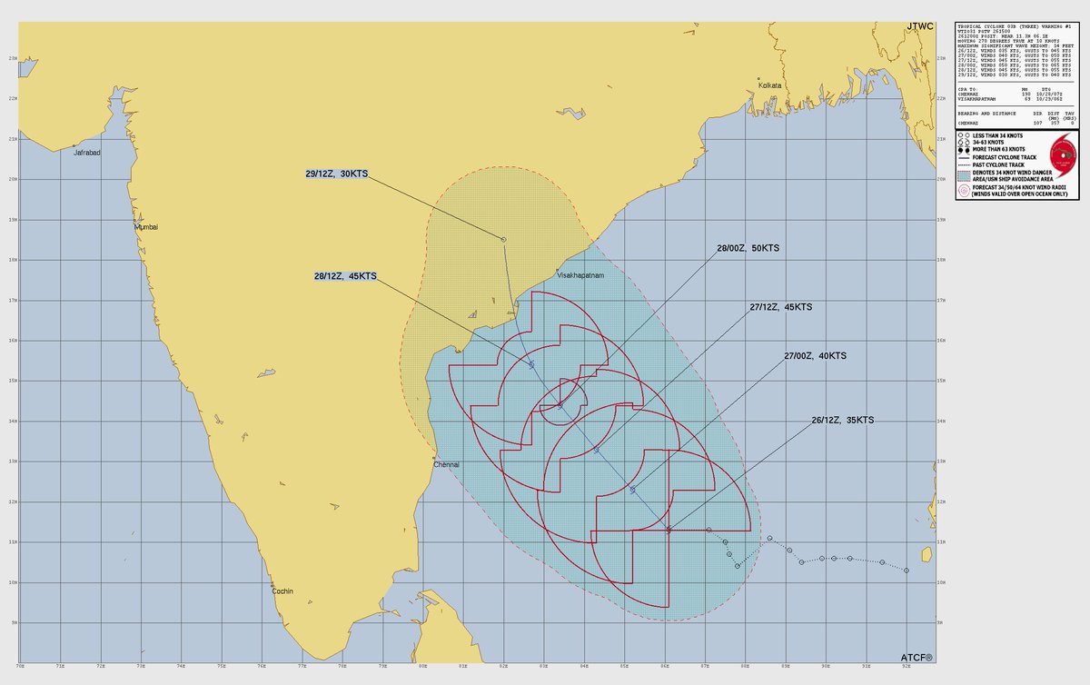
#94B System possible track by JTWC
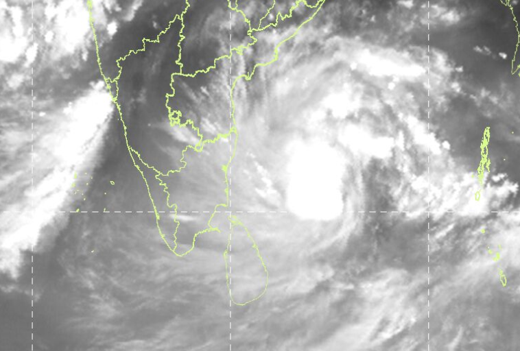
5:30 PM update: The #94B deep depression is wrapping rain bands around its center, with spiral bands gradually weakening. Moisture feed continues from the east, and the system is moving west/northwest at about 6 kmph. It is likely to intensify into a cyclone.
மாலை 5.30 மணி நிலவரம்: #94B ஆழ்ந்த தாழ்வு மண்டலம் மையத்தைச் சுற்றி மேகங்கள் திரள்கின்றன. சுழல் மேகங்கள் மெல்ல சிதைந்து வருகின்றன. கிழக்கிலிருந்து ஈரப்பதம் தொடர்ந்து சேர்ந்து கொண்டு,மண்டலம் மேற்கு/வடமேற்குத் திசையில் சுமார் 6 கிமீ வேகத்தில் நகர்கிறது. இது புயலாக வலுப்பெறும் வாய்ப்பு உள்ளது.
System #94B is still far from #Chennai, with winds flowing in a North–South pattern.
Don’t be misled by the rain bands visible on radar about 100 km away — they won’t reach us.
Don't fall trap to "Puli Varuthu" stories.
#94B மண்டலம் இன்னும் #சென்னைக்கு மிகவும் தூரத்தில் உள்ளது. காற்று ஓட்டம் வடக்கு–தெற்கு திசையில் வீசுகிறது.
ரேடாரில் 100 கிமீ தூரத்தில் காணப்படும் மழை, நம்மை ���டையாது.
���புலி வருது” கதைகளில் விழுந்து விடாதீர்கள்.
This forecast till intact #94B
All set to form a first named cyclone #montha, and is expected to landfall near #andhra coastal districts near #machilipatnam around 28th.
Please be vigilantly and follow the advisory from the official agencies.
#weather #cyclonealert #94B

Next 24-36hrs ECM/GFS projections on movement..
#Cycloneupdate #Update #Bayofbengal #94B
#Chennai #ChennaiRains #TNRains #AndhraPradesh
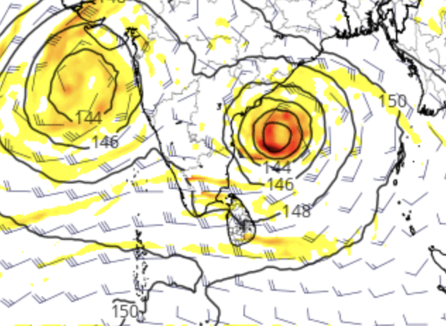
#94B system has moved west last 6 hours

𝘾𝙔𝘾𝙇𝙊𝙉𝙀 𝙈𝙊𝙉𝙏𝙃𝘼 𝙐𝙋𝘿𝘼𝙏𝙀 𝙁𝙊𝙍 𝘾𝙃𝙀𝙉𝙉𝘼𝙄 𝘼𝙉𝘿 𝙆𝙏𝘾!?
Depression #94B may not make its landfall prowess in Chennai/ North TN- and it is pretty much in consensus to hit South central #AndhraPradesh coasts on Oct 28/29th. Currently situated 817km SE of #Chennai- all eyes on the system's movement next 12-24 hours which will mostly determine the rainfall prospects for KTCC☔️
𝙒𝙉𝙒- if it is able to breach 400km mark, heavy to very heavy rains are indeed expected on Oct 27th (tomorrow) till Oct 28th early morning.
𝙉/𝙉𝙒- more than 400km mark, depends on vertical wind shear to displace the convection in its W/SW quadrants (as ridge is extending down till NAP inducing a W/SW tilt) and based on real- time: moderate to slightly heavy rains are possible for KTCC!
Global models vary exactly here at this very movement- though they have arrived consensus on the landfall spot. This also brings us to a dilemma of what to expect from this possible #CycloneMontha!
𝙒𝙃𝘼𝙏 𝙏𝙊 𝙀𝙓𝙋𝙀𝘾𝙏?
--------------------
There is going to be #ChennaiRains- whether light or moderate, heavy or very heavy is yet to be determined. We should get clarity by tonight. Until then nowcasts and updates would be provided if there is any changes🌧️
𝙋𝙎-
One might argue that if this #cyclone misses to give rains, and with November first 10 days not looking good- are we looking at a rare failure of #NEM2025? We can't exactly be pessimistic right now.
Given the odds are pretty low at this point- one should also not forget that this particular even minuscule chance of getting rains is only available to Chennai and KTC in whole #Tamilnadu.
To add upon, we are already in pretty much excess for this year, to be exact- 57% excess for Chennai, 27% excess for #Chengalpet, 88% excess for #Kanchi and 113% excess for #Tiruvallur just counting from Oct 1. Let's not even count the bountiful excess SWM we had this year.
Let's just hope for the best! Stay tuned for further updates🌪️


The system #94B, which is developing into Cyclone Montha over the Bay of Bengal, is expected to move northwest toward the Andhra coast.
For Chennai, that means some heavy rain and gusty winds are likely between Oct 26–27, but the main cyclone impact should stay north — so no direct landfall is expected.
Vertical wind shear is moderate at 10 knots for system #94B
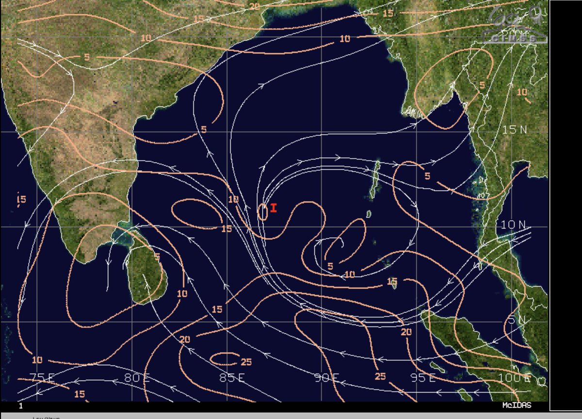

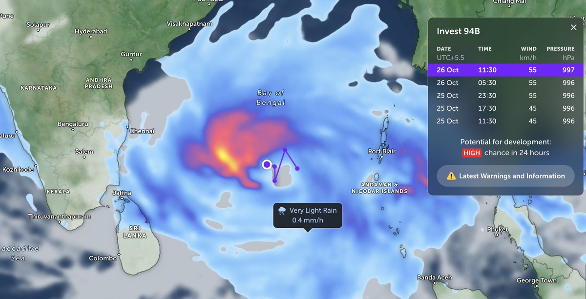
⚠️🔴 #Unofficially #94B Already Become Depression Yesterday Night And On Morning After 8:30 am It's On #Cyclone Processs And It's Have Chances To Become Cyclone By Late Evening 🌀 Target South India #AndhraPradesh #Vishakapatnam #Machlipatnam #Gopalpur #Odisha
⚠️🔴#Live #94B
📍Location: 11.2°N 87.5°E
🌬️Sustainable Wind: 60 Kmph
💨Gust Wind: 70 Kmph
📉Pressure: 996 hPa
🌀Vertical Wind Shear: Low To Moderate
🔴 Unofficial On #Cyclone Process Landfall Near #AndhraPradesh #Odisha
28 October Night
#CycloneUpdate #WeatherAlert #Breaking

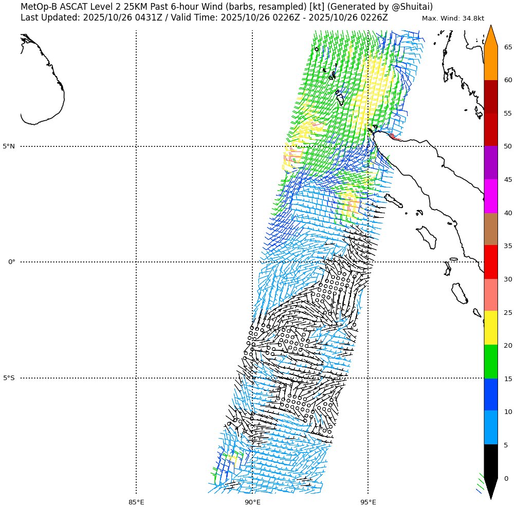
⚠️🔴#Live #94B
📍Location: 11.2°N 87.5°E
🌬️Sustainable Wind: 60 Kmph
💨Gust Wind: 70 Kmph
📉Pressure: 996 hPa
🌀Vertical Wind Shear: Low To Moderate
🔴 Unofficial On #Cyclone Process Landfall Near #AndhraPradesh #Odisha
28 October Night
#CycloneUpdate #WeatherAlert #Breaking
Trends for you
Most Popular Users

Elon Musk 
@elonmusk
241.7M followers

Barack Obama
@barackobama
119M followers

Cristiano Ronaldo
@cristiano
114.5M followers

Donald J. Trump
@realdonaldtrump
111.9M followers

Narendra Modi
@narendramodi
107.2M followers

Rihanna
@rihanna
98.7M followers

NASA
@nasa
92.4M followers

Justin Bieber
@justinbieber
91.8M followers

KATY PERRY
@katyperry
90M followers

Taylor Swift
@taylorswift13
84M followers

Lady Gaga
@ladygaga
75.5M followers

Virat Kohli
@imvkohli
73.5M followers

Kim Kardashian
@kimkardashian
70.9M followers

YouTube
@youtube
68.8M followers

Neymar Jr
@neymarjr
66.5M followers

Bill Gates
@billgates
65.2M followers

Selena Gomez
@selenagomez
63.1M followers

The Ellen Show
@theellenshow
62.3M followers

CNN
@cnn
61.8M followers

X
@x
60.7M followers