

Top Tweets for #97l


Potencial Ciclón Tropical Cinco al norte del Golfo de México. En las próximas horas se convertirá en depresión o tormenta #Edouard, esperando impacte el sureste de Texas el martes.
No viene para #NuevoLeón o el noreste de México.
#TXwx #97L #Houston


As many have said it has been shocking the NHC has put a PTC advisory on #97L earlier this morning. I would place the center of circulation near 28N 90.8W based on satellite and oil platforms surface observations, maybe a little elongated? But the radar shows that the circulation could be a little farther E from there near 97.5W. Hard to tell with the radar so far away.
Oil platforms still don't show much a pressure fall, still very slow fall unless the LLC is so small and tight. Recon early this afternoon should give us a better answer.
SE TX/SW LA should be making preparations before landfall tomorrow afternoon/evening.
Edit: I had no idea the recon was already up investigation 97L, it seems like the LLC and MLC are not aligned thus the strengthening not happening yet.

#97L is holding on with its vorticity/circulation becoming more apparent and growing in height though convection has died out some, I see some evidence of surface pressures starting to come down a little bit this afternoon compared to 24 hrs ago. One thing I noticed this morning was the dry mid levels just to its north as seen from Slidell's sounding this morning but the ECMWF forecasts those dry conditions stay away from the circulation since northerly shear will not affect it like it did Bertha.


Invest #97L looks impressive on satellite, and the microwave scan shows a tight, powerful cluster of heavy thunderstorms firing right near the center of the storm, which means it's starting to pull itself together and gain strength. but Air Force reconnaissance tracked across the system capturing only flight-level winds primarily in the 20 to 30 knot range, Not enough to classify as a tropical depression yet.


TROPICS UPDATE: The disturbance just south of Louisiana - Invest #97L - is showing some signs of development. There is a flood threat from Metro Houston to SW Louisiana for tomorrow when the system, possibly as Tropical Storm Edouard, moves inland. More at https://t.co/f6mUwJotdm



Invest #97L is looking very healthy this morning and should be well on its way to becoming a Tropical Storm very soon as aircraft recon is currently flying into the storm. What ever this becomes will make landfall right on the Texas Louisiana gulf coast border. #tropicalwx #wx


Unfortunately the website is still down (hopefully will be fixed today) but the HAFS-multistorm experimental forecast we're running for the Atlantic has #97L reaching borderline hurricane strength before making landfall along the Texas coast tomorrow morning. Very small vortex, which seems consistent with observations at the moment.

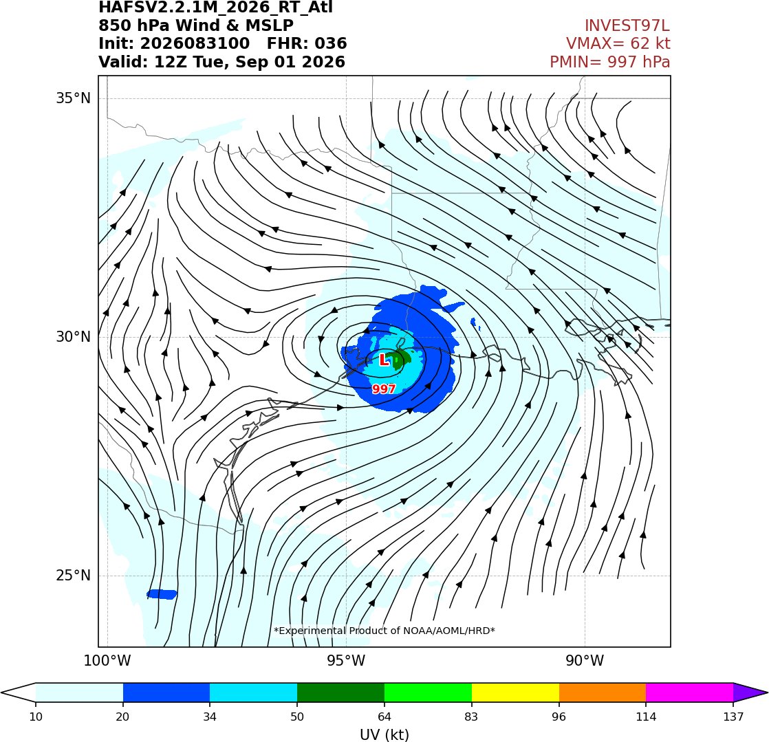


Yeah, yeah ... the closed circulation isn't there yet.
But Edouard-wannabe #97L looks more impressive than a couple of its earlier-season counterparts that got names.
A PTC advisory might be in order before it plows into the Texas coast.


TROPICAL UPDATE: Invest #97L odds haven't changed the past 12 hours, still at 70%. I feel the NHC wants to wait until the Hurricane Hunters get a better look at it this thing under the hood. Considering this will be pushing onshore *tomorrow* in TX/LA, I still would have preferred Potential Tropical Cyclone/System to be designated so more tropical weather alerts and communication products could have been issued. For example, my sister is a teacher in the Galveston Bay area. She is under the impression she is going to school Tuesday (along with her kids) because a Tropical Storm Watch/Warning has not been issued yet. The school district needs that additional information to make better decisions. I have a lot of respect for the NHC, I just disagree with them on this one.
Really no clue how #97L doesn't have at least a PTC tag this morning. Looking quite healthy, much better than last night.


Looks like #97L might be the only feature of note in the Atlantic for a while. Models have pretty much completely dropped any idea of redevelopment for Dolly further west. There will be a few more waves rolling across the MDR these next couple weeks, but hostile shear and subsidence from El Niño looks like it will likely shut down the basin at the climatological "peak". It's impressive how hostile this year has been - we've had even less activity than the last 2 "super Niños" (1997 and 2015). This year could flirt with being historically quiet at this rate.


Most Popular Users

Elon Musk 
@elonmusk
241.5M followers

Barack Obama
@barackobama
118.8M followers

Cristiano Ronaldo
@cristiano
114.6M followers

Donald J. Trump
@realdonaldtrump
111.8M followers

Narendra Modi
@narendramodi
107.1M followers

Rihanna
@rihanna
98.7M followers

NASA
@nasa
92.3M followers

Justin Bieber
@justinbieber
91.8M followers

KATY PERRY
@katyperry
90.1M followers

Taylor Swift
@taylorswift13
84M followers

Lady Gaga
@ladygaga
75.5M followers

Virat Kohli
@imvkohli
73.5M followers

Kim Kardashian
@kimkardashian
70.9M followers

YouTube
@youtube
68.8M followers

Neymar Jr
@neymarjr
66.5M followers

Bill Gates
@billgates
65.3M followers

Selena Gomez
@selenagomez
63.1M followers

The Ellen Show
@theellenshow
62.2M followers

CNN
@cnn
61.7M followers

X
@x
60.7M followers