12.5" of snow tonight in Scotch Hill, NY. This is just outside of Hartwick (Otsego County) in New York. This is the largest snowfall measurement so far and comes from Tommy Potter.
Double-digit snow totals already showing up across portions of central NY this evening. 10" at Cherry Valley (2000ft elevation) with snow still falling thru the night.
But wait, there’s more!
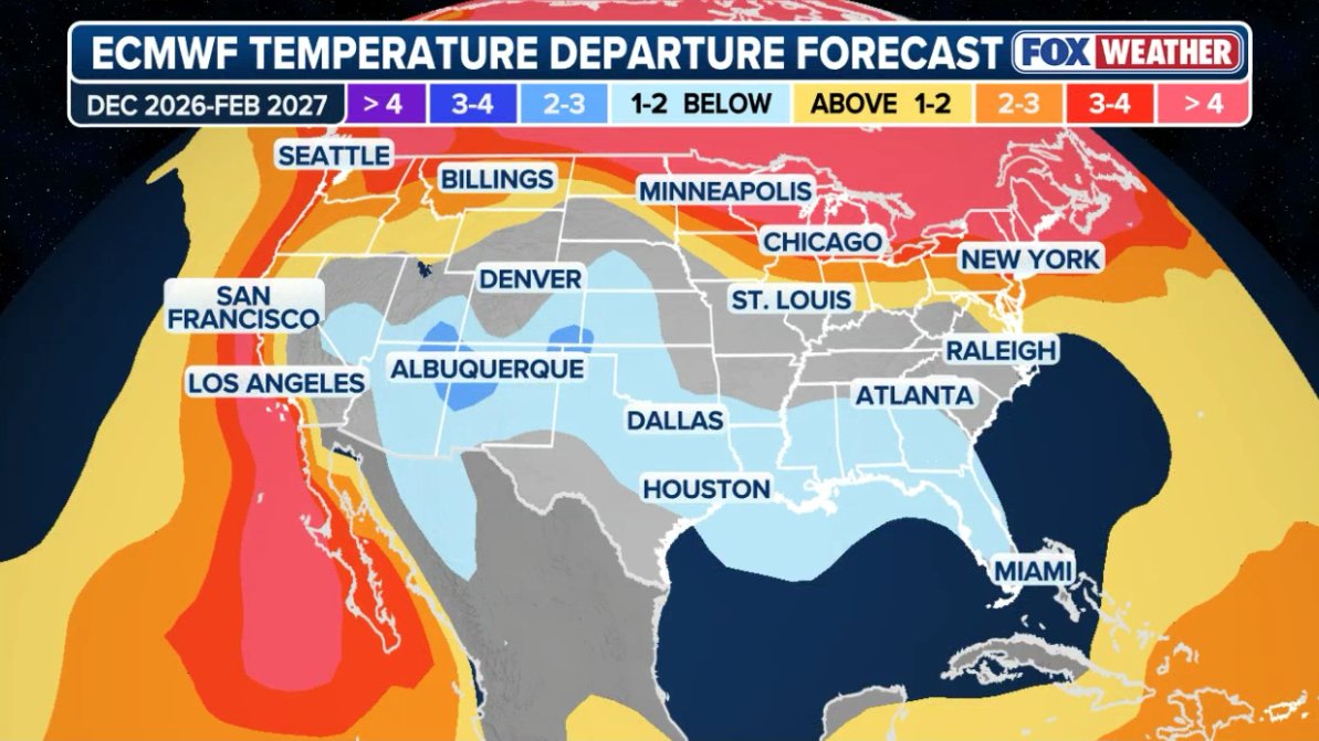
In many seasonal blends, February is responsible for a lot of the action. This matches a common theme of strong Niños being back loaded versus front loaded. NC 👀
The warmest month on average in a super nino in relation to average is December. The Euro Ensemble control run is painting a pattern that I'm not quite sure I've seen before...
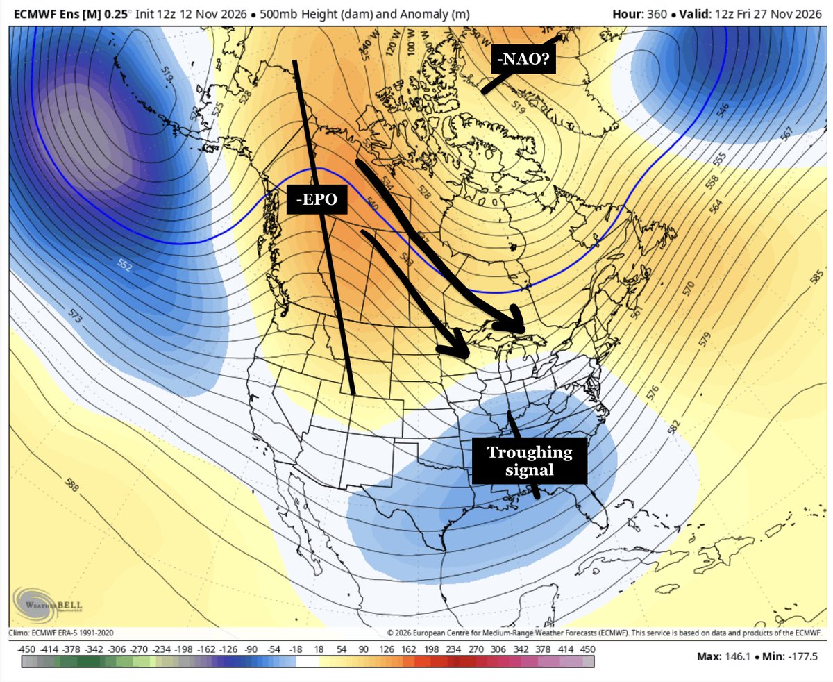
Now... looking more long range:
(1) A warmup is expected with above average temperatures with a strong ridge for the end of the upcoming week. A southwest flow will lead to positive height anomalies over the eastern US.
(2) The pattern will likely change Thanksgiving week as a -EPO develops, pushing colder air south.
(3) A troughing signal develops over the southern US. We'll have to wait & see if this is able to interact with the cold air pushed southward from the Alaskan ridge.
(4) I'm watching for a 2 week opportunity (Nov 28-Dec 12) for a potential impactful snow event somewhere across the Great Lakes/Mid-Atlantic/Northeast US.
#EcWx
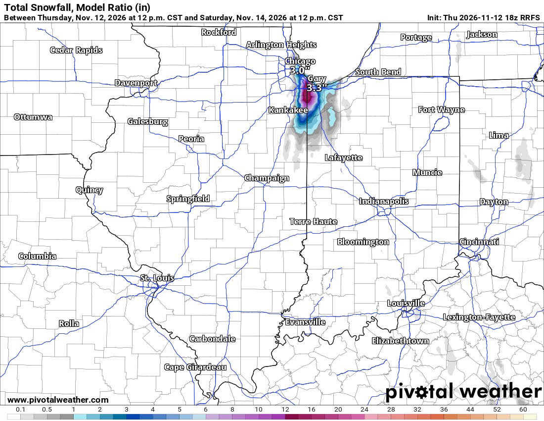
LES event continues to uptrend for the northern end of the IL/IN border, not too far from Chicago. Roofus and the HRRR both have some spots of 8-16", which is honestly not out of the realm of possibility here. Ground temps are warm, but this will be HEAVY snow. Perhaps 3"+/hour.
** PENNSYLVANIA SNOW FORECAST UPDATE **
Okay... back to the attention of snow! The first round of snow will be coming late tonight and will last through Friday morning, and possibly into midday Friday. This will be across Northeastern/Eastern Pennsylvania as rain changes over to snow. Snow can briefly be heavy in the highest elevations of the Poconos, especially at elevations greater than 1500 feet. The second round will be focused Friday night through Sunday, as we will see broken snow showers mixed with rain across western Pennsylvania due to lake effect.
AREA A: Snowfall accumulations of 2 to 4 inches expected, locally up to 5 inches at elevations up to 2000 f. Snow-covered roadways may be a concern early Friday morning, especially during steadier periods of snow.
AREA B: Light snowfall accumulations expected. 1 to 2 inches of snow, with localized amounts up to 3 inches. You may not see this all at once, as it may melt back at times. Watch for locally slushy roadways, especially during times of steadier snowfall.
AREA C: Very light snowfall accumulations. Generally, coatings of up to a half inch of snow are expected, with localized amounts up to 1 inch. Roadway impacts generally not expected, unless you see a steadier period of snow or a heavier shower during the overnight hours.
AREA D: First flakes of the season expected. Snowfall accumulations are not expected outside of a steadier burst, which may briefly coat surfaces before melting back. Not everyone may see flakes, especially if you are missed by the snow showers and/or temperatures do not cool enough to switch rain to snow.
Stay tuned for updates & happy snow season!
#PAwx #Pennsylvania #Snow #November #Weather
Inspired by @BenNollWeather's tweet this morning, we did our own analysis to see how active the East Coast could be this winter. The SEAS5 forecast shows the potential for an additional 2-4 storms (DJF). Whether those are wet or white is TBD. Coastal impacts are up regardless.