Top Tweets for #BAVI

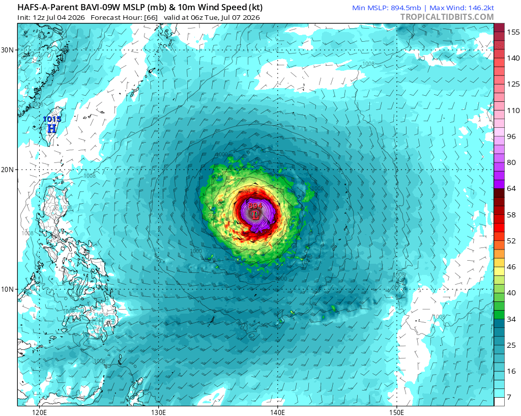
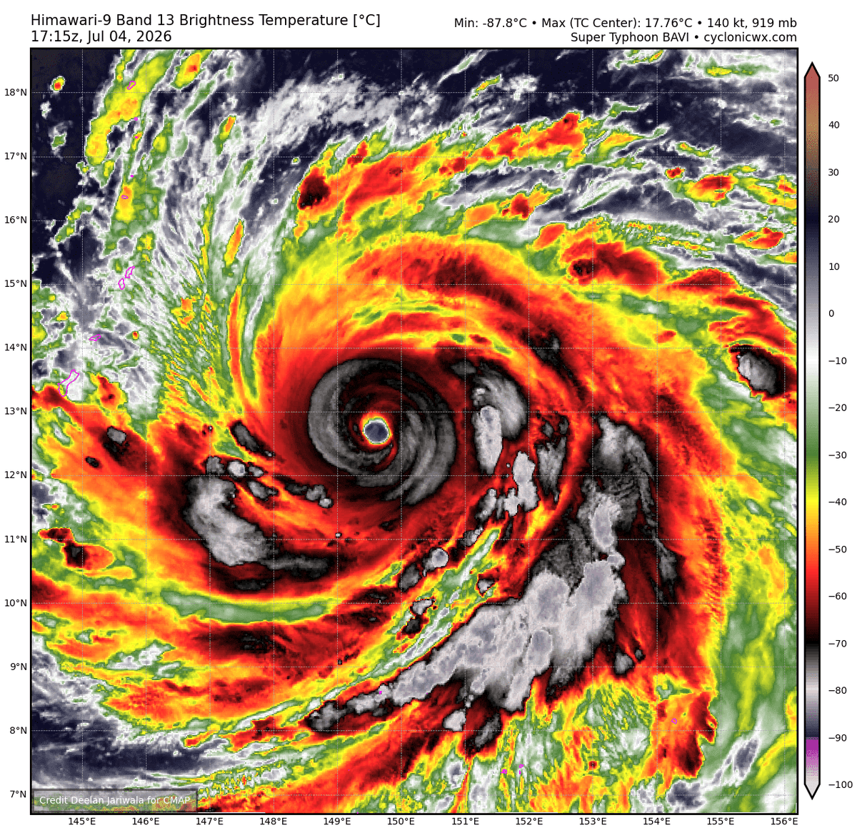
Super Typhoon #Bavi is undergoing a EWRC, where a secondary, outer convective ring chokes off the primary inner core. While this process temporarily caps the peak intensity by disrupting the inner core's momentum, it does not reduce the threat, it redistributes the storm's energy over a significantly larger radius.
The collapse of the inner eye and the contraction of the outer eyewall will result in an expanded wind field, dramatically increasing the area vulnerable to destructive sustained winds and severe storm surge.

Prime upper level outflow and pristine OHC don't mean nothing when you're fighting yourself... Typhoon #Bavi is still struggling with his EWRC, as the 2 eyewalls battle for dominance in the storm's core.


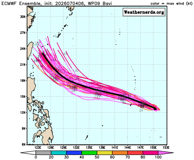
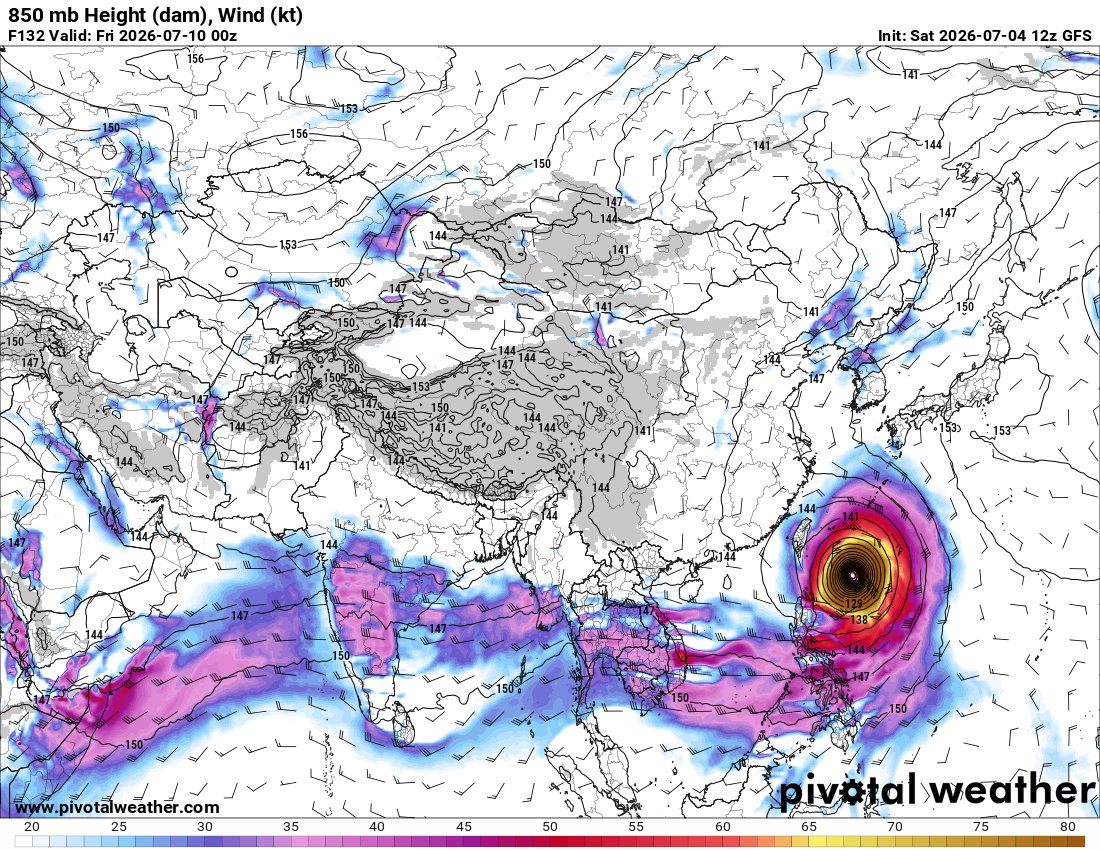
Super #Typhoon #Bavi has now reached Category 5, the highest classification. 🧐🌀 Over the coming days, it is expected to continue moving westward, reaching Taiwan and eastern China in the second half of next week. ⚠️ It is still uncertain whether the eye will make landfall on Taiwan or pass just offshore. This is the current forecast from the American GFS model.
Super #Typhoon #Bavi has now reached Category 5, the highest classification. 🧐🌀 Over the coming days, it is expected to continue moving westward, reaching Taiwan and eastern China in the second half of next week. ⚠️ It is still uncertain whether the eye will make landfall on Taiwan or pass just offshore. This is the current forecast from the American GFS model.

Some extremely deep warm water ahead in the path of Super Typhoon #Bavi. Some of this water near 130-160E has OHC of 140-160kj/cm2.
Microwave imagery depicts an ERC is potentially underway, but #SuperTyphoonBavi has a pretty thick inner eye wall, so it will be interesting to see how the Typhoon handles this.
The ERC will result in a much bigger Typhoon than we currently have in terms of aerial size.
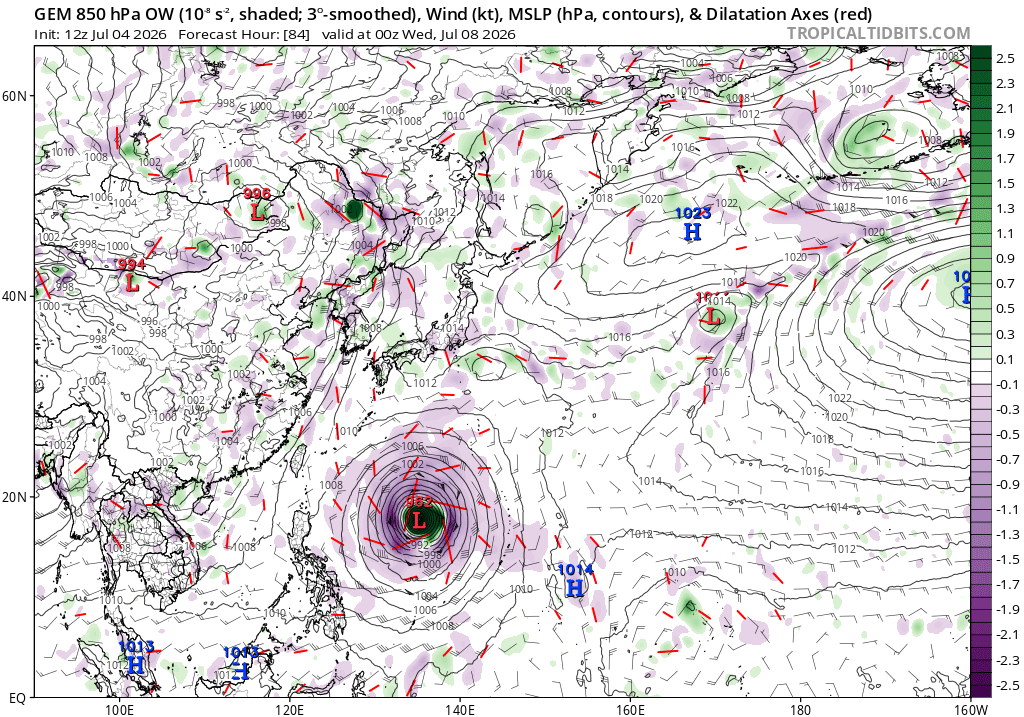
There is forecast to be an extremely favourable upper level environment ahead of #Bavi as shown in the Divergence field on the below graphic which large divergent indicators (red lines) moving away from Bavi. This on the Southern Side (SW Side) of the STR to the North.
Need to watch if BAVI can move more south some of the forecast models as shown by the HWRF/earlier ECMWF ensembles.
It is possible that 150-250mb outflow from #Bavi could just enhance the ridge to the NE for a little longer which could knock #Bavi more westward towards Eastern Taiwan.
Taiwan itself is notorious for affecting or even nudging Typhoons in different directions,
Taiwan’s spine rises to 3,000–4,000 m, running north–south almost perfectly.
A Typhoon approaching from the east hits a wall of terrain that can :-
Block low‑level inflow
Deflect the vortex north or south
Tilt the storm vertically
Disrupt the inner core
Create asymmetric frictional drag....... but
It’s not just the mountains — it’s the entire environment: terrain, coastline, bathymetry, ridge dynamics, thermal contrasts, and chaotic wake effects.
All of these combine to make the approach to Taiwan one of the most complex landmasses for tropical cyclone track prediction anywhere on Earth & one where local forecasters and Storm Chasers of the region know their stuff.


EPAC AOI; 0/10- Development is unlikely.
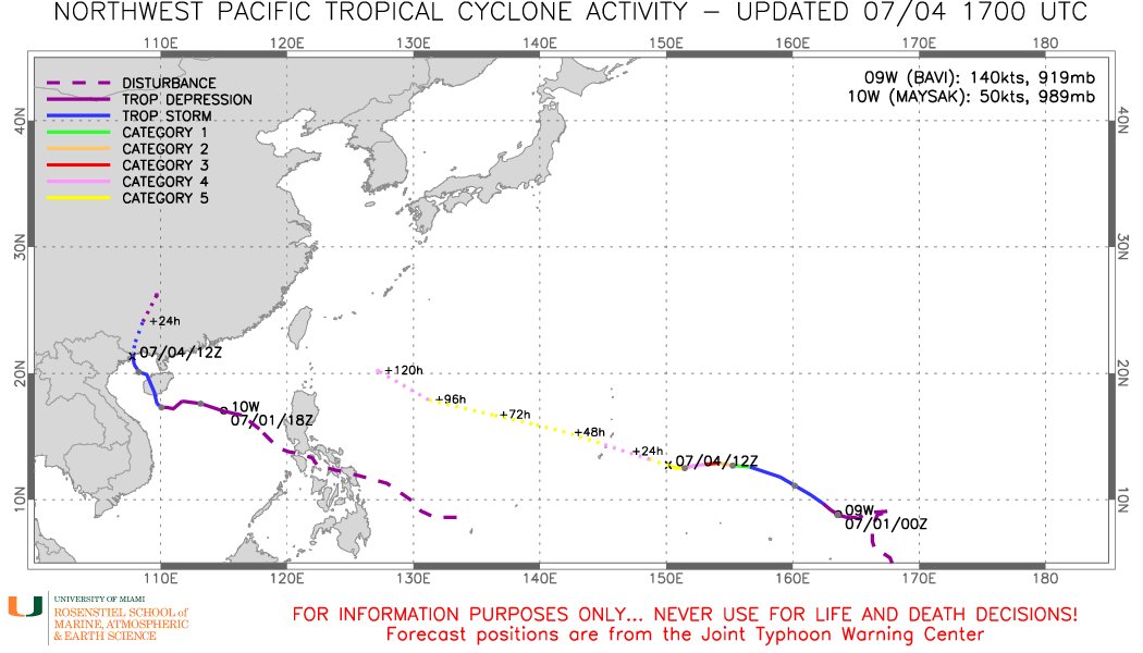
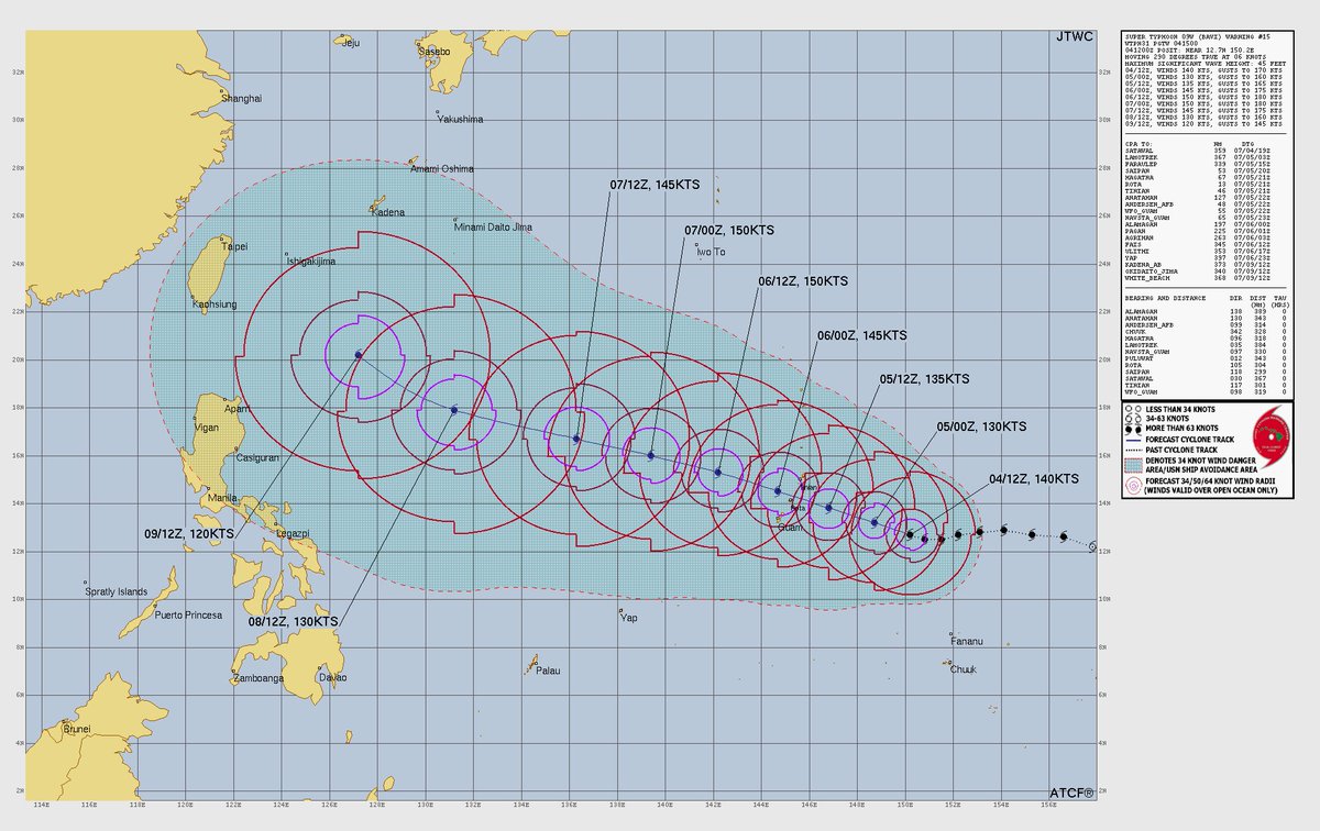
#BAVI; 160mph 919mb
STY nearing the Mariana Islands. Preparations should be RUSHED to completion if they haven't been already.
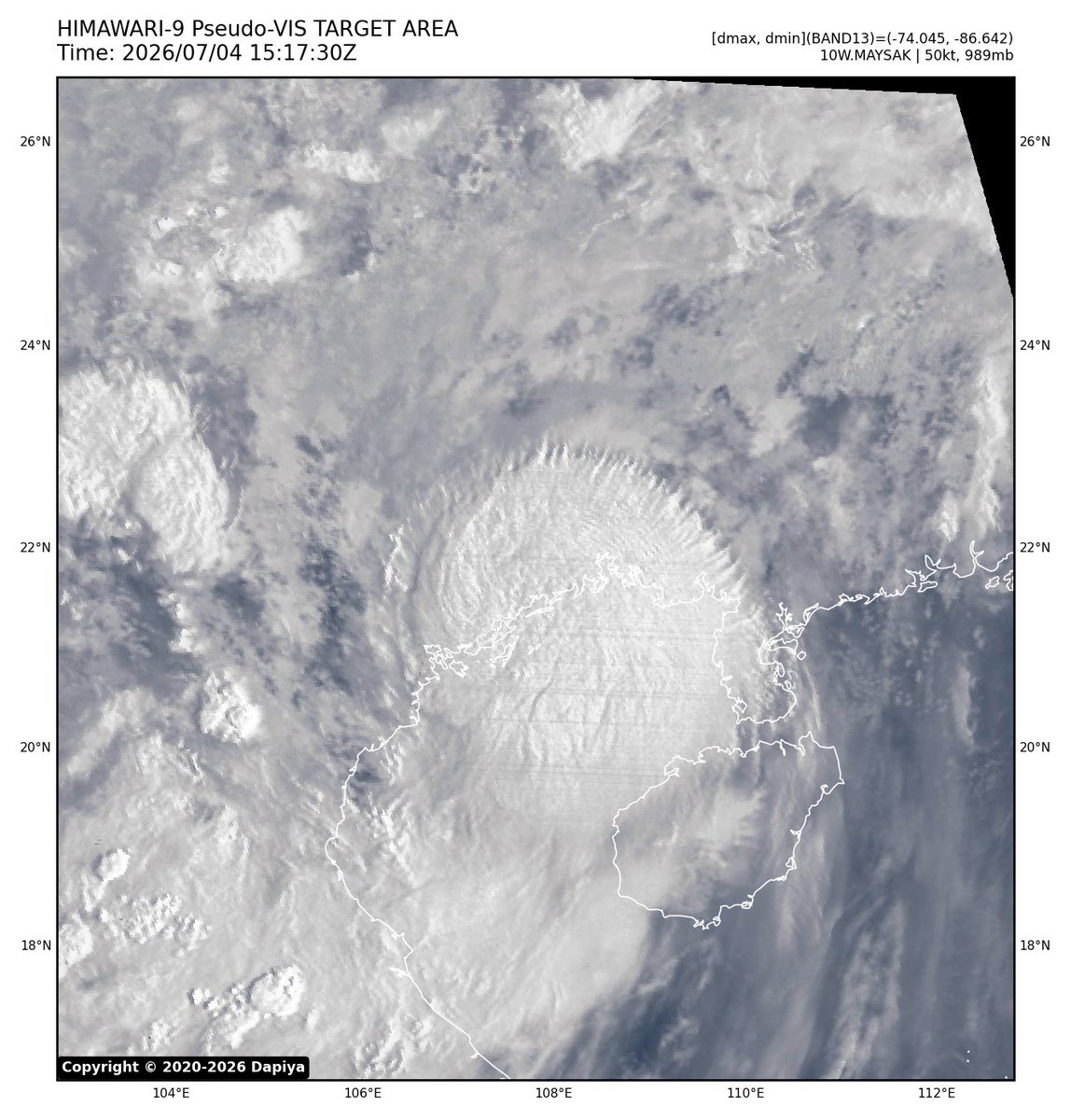
#MAYSAK; 60mph 989mb
Maysak makes landfall near the China/Vietnam coast as a TS.
#97P; LFC in 48hrs.
#wxtwitter


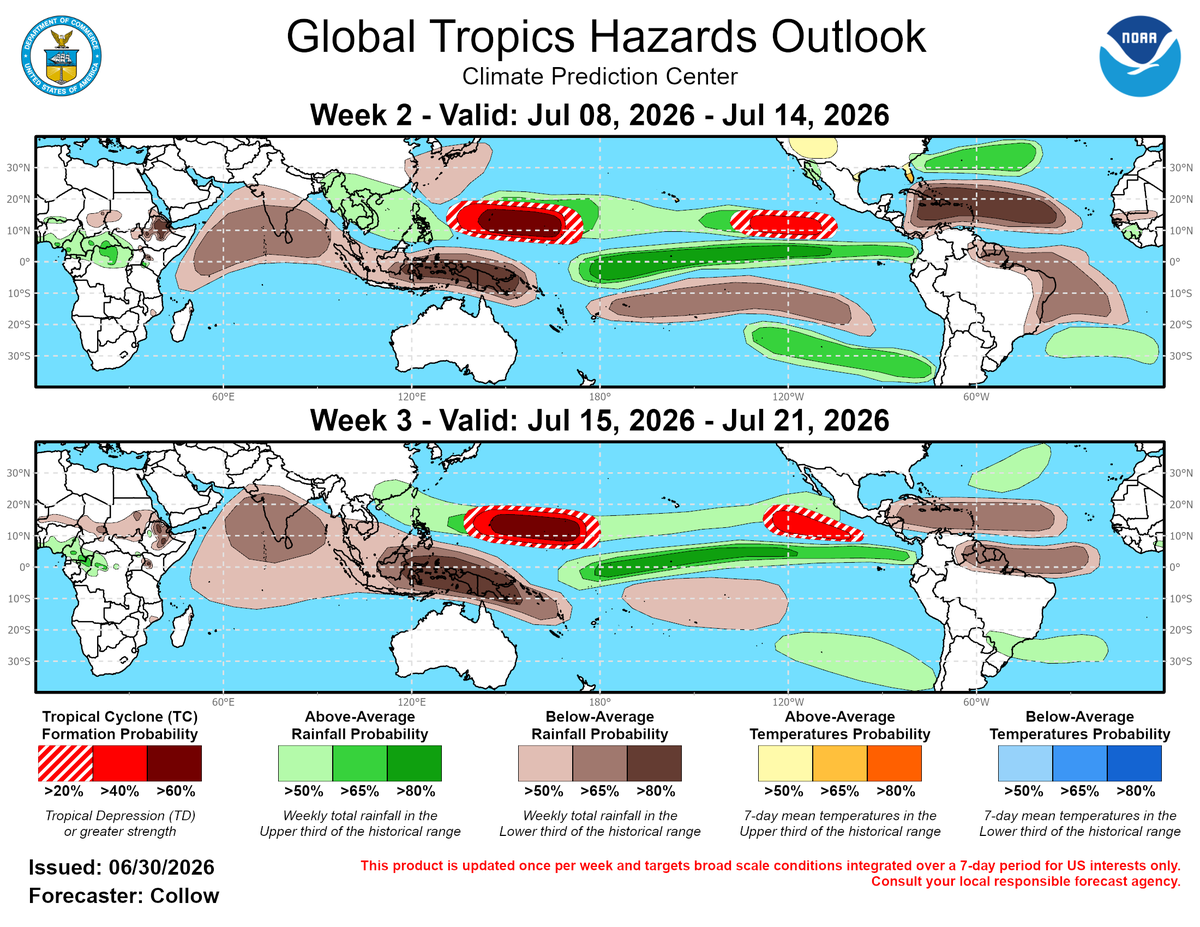
Potential is there for multiple additional Typhoons to form after Super Typhoon #Bavi in the Western Pacific in mid July. The CPC highlights both weeks 2 and 3 with >60% chances of tropical development. This is expected with a strong El Niño.

الوحش #Bavi يرتقي إلى سوبر تايفون بسرعة رياح تصل إلى ١٤٠ عقدة وضغط سطحي مركزي ٩١٩ mb
توقعات بأن يشتد أكثر خلال ٤٨ وربما نشاهد قيم ضغط اقل من ٨٩٠ مب
لاحظوا كيف ان النظام المداري بسبب حجمه وعمقه متوقع أن يستحوذ على جل نشاط المونسون شمال المحيط الهندي نهاية الأسبوع


#Vaguada mantiene alertas en RD y #Bavi se convierte en supertifón en el #Pacífico #pronosticodeltiempo #RepúblicaDominicana
https://t.co/1FfGaal3e7

Looks like wobbles + track biases instigated by internal asymmetries may bring STY #Bavi much closer to the southern end of the Marianas islands, especially Rota and Guam.
Accounting for this, ensembles like Google DeepMind now deviate noticeably south of the official forecast.


Super Typhoon #Bavi is undergoing an EWRC, where a secondary, outer convective ring chokes off the primary inner core. While this process temporarily caps the system's peak intensity by disrupting the inner core's momentum, it does not reduce the threat, it redistributes the storm's energy over a significantly larger radius.
The collapse of the inner eye and the contraction of the outer eyewall will result in an expanded wind field, dramatically increasing the area vulnerable to destructive sustained winds and severe storm surge.

Bavi is start to have an impact on the islands with coastal surge cause of erosion. This is still a monster typhoon on satellite. But it starts to slow down its speed of movement now toward the islands which is normal before landfall. Stay tuned for more updates as we come.


@Arab_Storms #Bavi #hurricane #Typhoon
Hurricane/Typhoon Bavi is rated as a Category 5 Super monster matching Hurricane Katrina (2005)
a Category 5 monster https://t.co/fgDPX39st9

#VedicMeteorology #Turbulence
#Monsoon
#Hurricane #Typhoon #Earthquake
Keep Track of Forecasts based on Vedic Meteorology posted by a Novice Researcher 👇
https://t.co/feHlITPhf6


Super Typhoon #Bavi currently has maximum sustained winds of 160mph with 195mph wind gusts and it is moving west northwest at 7mph. It is still forecast to peak as a 175mph Super Typhoon with wind gusts of 205mph as it impacts the Northern Mariana Islands and Guam with moderate to heavy to very heavy rainfall/gusty to damaging to destructive winds/significant storm surge #guam #wind #typhoon #supertyphoon #tropicswx #tropicalupdate #wxtwitter #severewx #rainfall #flooding #BREAKING

Several countries on #Bavi #SuperTyphoon Category 5 will it turn into mega typhoon. --->
Bavi now CAT 5 super typhoon, track slightly closer to Guam as of Saturday morning | News | https://t.co/ZGDRK5mIu6 https://t.co/bPUy0V845s


Last Seen Hashtags on Sotwe
sissy
Seen from Germany
nolimit()*filter:native_video
Seen from Turkey
hazelmoore dp
Seen from Oman
يمنيه
Seen from Netherlands
adanabayan
Seen from Turkey
teenagergirls
Seen from Switzerland
あられもない祈り
Seen from Japan
はぴフル
Seen from Japan
mbahmaryono
Seen from United States
solo masturbation
Seen from South Africa
Most Popular Users

Elon Musk 
@elonmusk
240.7M followers

Barack Obama
@barackobama
119.2M followers

Donald J. Trump
@realdonaldtrump
111.7M followers

Cristiano Ronaldo
@cristiano
110.8M followers

Narendra Modi
@narendramodi
107M followers

Rihanna
@rihanna
97.7M followers

NASA
@nasa
92.2M followers

Justin Bieber
@justinbieber
90.9M followers

KATY PERRY
@katyperry
87.8M followers

Taylor Swift
@taylorswift13
81.6M followers

Lady Gaga
@ladygaga
73.1M followers

Virat Kohli
@imvkohli
70M followers

Kim Kardashian
@kimkardashian
69.8M followers

YouTube
@youtube
68.7M followers

Bill Gates
@billgates
63.9M followers

Neymar Jr
@neymarjr
62.8M followers

The Ellen Show
@theellenshow
62.4M followers

CNN
@cnn
61.9M followers

Selena Gomez
@selenagomez
60.8M followers

X
@x
60.8M followers