

Top Tweets for #FireWXWatch

A Fire Weather Watch #firewxwatch has been issued for the Los Padres National Forest (LPNF) for this Wednesday (07/15).
Below are the details:
...FIRE WEATHER WATCH IN EFFECT FROM WEDNESDAY
AFTERNOON THROUGH THURSDAY MORNING FOR STRONG NORTHWEST TO NORTH WINDS ALONG WITH LOW RELATIVE HUMIDITY AND HOT TEMPERATURES FOR THE
MOUNTAINS AND SOUTH COAST OF SANTA BARBARA
COUNTY AS WELL AS THE VENTURA COUNTY MOUNTAINS AND INTERSTATE 5 CORRIDOR...
Strong northwest to north winds, hot temperatures, and low relative humidity will produce the potential for critical fire- weather conditions late Wednesday through early Thursday. The National Weather Service in Los Angeles/Oxnard has issued a Fire Weather Watch for strong northwest to north winds along with low relative humidity and hot temperatures, which is in effect from Wednesday afternoon through Thursday morning.
WINDS: Northwest to north winds 20 to 30 mph with gusts of 45 to 55 mph, strongest in Sundowner wind prone areas of southern Santa Barbara County.
RELATIVE HUMIDITY: 10 to 25 percent.
IMPACTS: If fire ignition occurs, conditions are favorable for extreme fire behavior, rapid fire growth, and long range spotting, which could threaten life and property. The hot air mass will also contribute to the potential for significant vertical plume growth.
Instructions: A Fire Weather Watch means that critical fire weather conditions are likely to occur in the coming days.
Residents near wildland interfaces should prepare now on what to do if a wildfire breaks out. See https://t.co/6Ng0laJWrE and https://t.co/NHC3Dm3TVT for information.

Hello followers, I hope you are all doing well. The long-awaited forecast for the upcoming #heatwave is here!
Below, I will go over what the temperatures are, where it will be the hottest, and the potential #firewx ramifications.
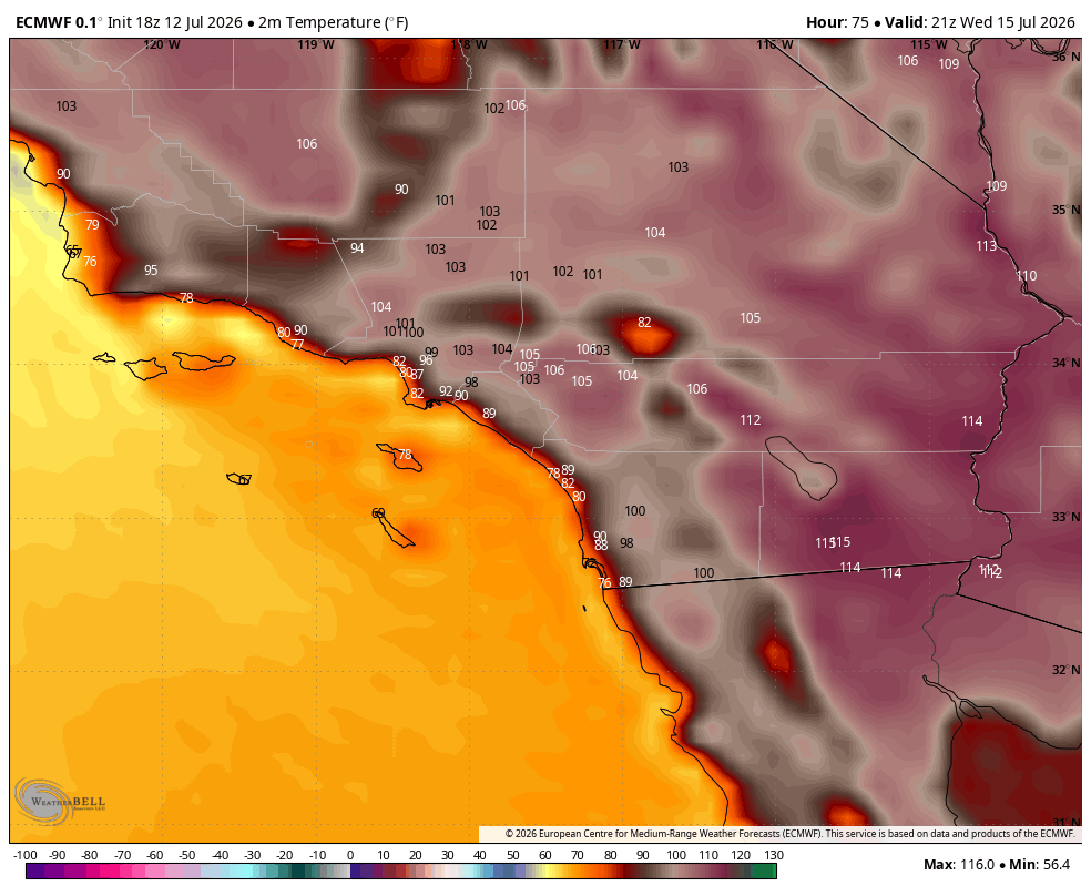
Temperatures:
First off, the weather models have been highly consistent, showing upper-90°F temperatures for a majority of the week.
The highest temperatures look to be centered in the Inland Empire and the deserts east of the mountains. The areas expected to experience the most widespread intense heat are Riverside and San Bernardino counties, where temperatures look to hover anywhere from 100°F to 106°F. Coast-facing slopes could see temperatures ranging from 89°F to 98°F.
Wednesday through Thursday look to be the hottest days of the week.
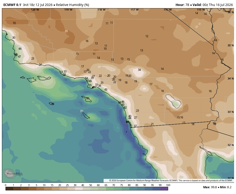
Humidities:
Coinciding with the peak heat mid-week, the humidity looks to be low around the same time frame: humidities, or RH values, look to hover around the 20-40% range on coast-facing mountains. However, the further you go Inland toward the Inland Empire and the deserts, humidity values drop into the 13-20% range.
Wind:
Winds during this #heatwave looks to be pretty mild with sustained winds down by the coast around 5-8 mph gusting up to about 15-20 mph coming out of the southwest (SW).
With the Inland Empire being encapsulated with mountains, the coastal winds may to force their way into inland areas and deserts: sustained winds look to be 10-13 mph with higher speeds of 16 mph in localized areas of the Antelope Valley and eastern Kern County. Gusts in the IE look to be around 23-24 mph with localized gusts of 28-32 mph.
Fire Weather:
Widespread signifiant fire concerns look be low risk per the NIFC. However there is an important caveat: the risk of a fire becoming an aggressive, fast-moving incident locally remains elevated due to hyper-local weather alignments.
The Inland Empire is most at risk because coastal winds often act as what I refer to as a "Reverse Santa Ana Wind event": where the coastal winds become stronger on the desert or east facing side of the Santa Ana Mountains.
The #BainFire serves as a recent example of this type of setup. That incident showed how effectively localized onshore gusts and low inland RH can drive a fire when temperature's peak, highlighting the ground-level risks despite low risk forecast.
Conclusion/Summary:
To recap, this upcoming mid-week heatwave brings a highly volatile combination of triple-digit temperatures up to 106°F, critically low inland humidity down to 13–20%, and localized afternoon gusts pushing 23–32 mph through mountain gaps. This terrain-driven "reverse Santa Ana" setup has the perfect alignment to rapidly accelerate a new ignition out of the gate, much like the dynamics observed during the #BainFire
While regional maps show low risk, the ground reality in the Inland Empire next week will be highly receptive to fires. Practice situational awareness, avoid activities that create sparks, and stay tuned for live updates if any smoke columns appear. Stay safe out there, everyone.
Over and out,
InfernoWatch


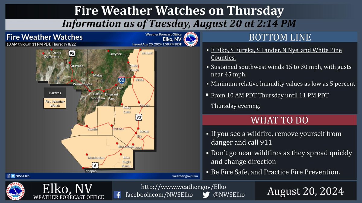
A Fire Weather Watch has been Issued for the potential for Critical fire weather conditions of strong winds and low relative humidity (RH) for Thursday August 22nd, 2024.
This watch covers E Elko, S Eureka, S Lander, N Nye, and White Pine Counties. #NVwx #FireWxWatch
Fire Weather Watches for Critical Fire Weather conditions of strong winds and low relative humidity (RH) is in effect this weekend. Please practice fire prevention and safety! In these conditions any spark will catch quickly, and spread rapidly out of control. #NVwx #FireWxWatch

A Fire Weather Watch remains in effect for Northern and Central Nevada from 12 PM PDT Monday afternoon until 8 PM PDT Monday evening. The combination of critically dry fuels, very low relative humidity values, and strong, gusty south to southwest winds. #NVwx #FireWXwatch


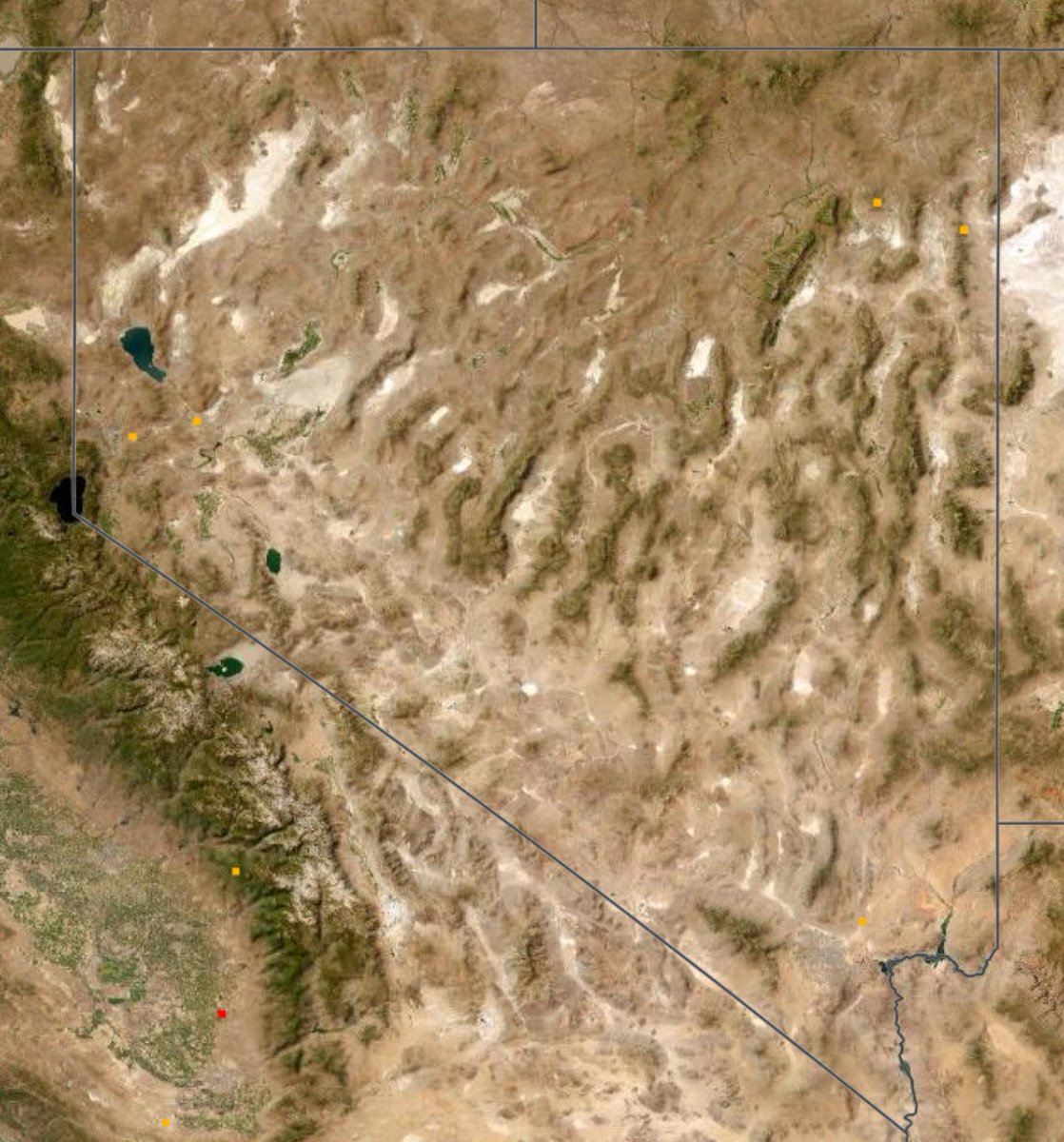
NV Fire Stats:
VIIRS / MODIS 15 Jun 2024 #NV #FireWX #FireWXWatch #NVWildfire
#SchurzFire #Mineral
65 ac
H-9FF, MARLETTE , BC 3106, CCD 3361, BC 3107, BC 12, CCD 3362, HTF 323, HTF 317
#LittleCedarFire #Elko
3 ac >12 hours data
E-1443, B-5231, DZR 1806

Highs warming to the mid 90's Thursday and Friday. The triple digits should be here by the weekend, but then back to the 80's next week? More: https://t.co/OoHaNrBI8i @RoyalNorman @seanontv
#azwx #azheat #firewxwatch
Fire WX Watch vs Red Flag Warnings-We May Have Both This Week Your forecast tonight with @PaulHorton_tv @RoyalNorman & @SeanonTV #azwx #FirstAlertWX #azfamily #redflagwarnings #firewxwatch

A Fire Weather Watch until 6 PM for counties filled in with Red. Wind of 15-25 mph, gusts of 30-40 mph and low Relative Humidity Values are expected. Please DO NOT BURN!!! DO NOT BURN!!! DO NOT BURN!!! #FireWXWatch
A brief and slight cool down commences Tue as temps fall into the low 80’s to low 90’s. Weak mid-level moist flow will produce Scattered dry T-Storms Wed through Fri. A Fire Weather Watch is in effect 6/23 for Elko, N Eureka, and N Lander Counties. #nvwx #cooler #FireWXwatch


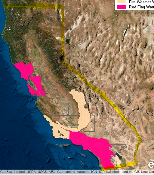

Keep up with wx forecasts this week! Possible wind events in central and northern CA mid-week. Make sure you know what to do in emergency and follow first responder instructions. If they say evacuate, GO! #FireWxWatch #HaveAPlan #USFS

The Fire Weather Watch begins at 4 AM PST Wed for the North Bay Mtns, East Bay Hills, & Diablo Range. A combination of the offshore winds, low relative humidity values, & unseasonably dry fuels will likely lead to critical fire weather conditions for the higher elevations. #CAwx


A #FireWxWatch is now in effect for portions of the #SoCal for late Thursday night through Monday. http://t.co/fIwFq7rmkm

#FIREWXWATCH: Sunday. Ern Urban Corridor, i.e., along & east of I-25, & the Nern High Plains. This does include the city of #Denver. #COwx
Most Popular Users

Elon Musk 
@elonmusk
241M followers

Barack Obama
@barackobama
119.2M followers

Cristiano Ronaldo
@cristiano
111.8M followers

Donald J. Trump
@realdonaldtrump
111.8M followers

Narendra Modi
@narendramodi
107M followers

Rihanna
@rihanna
98M followers

NASA
@nasa
92.2M followers

Justin Bieber
@justinbieber
91.2M followers

KATY PERRY
@katyperry
88.3M followers

Taylor Swift
@taylorswift13
82.2M followers

Lady Gaga
@ladygaga
73.7M followers

Virat Kohli
@imvkohli
70.9M followers

Kim Kardashian
@kimkardashian
70.1M followers

YouTube
@youtube
68.7M followers

Bill Gates
@billgates
64.3M followers

Neymar Jr
@neymarjr
63.8M followers

The Ellen Show
@theellenshow
62.4M followers

CNN
@cnn
61.8M followers

Selena Gomez
@selenagomez
61.4M followers

X
@x
60.8M followers