Top Tweets for #MapOTD

Map of the Day: This map from December 1974 shows the range of 13 barren-ground caribou herds, under threat from the planned route of the Trans-Alaska pipeline. Senior graphics editor Brian Jacobs has selected maps of oil, gas, and the environment for this week's #MapOTD

Map of the Day: Prince and peasant, milkmaid and falconer, countess and cavalier: Royal France lives on in this embellished map from 1966. Artist Janet Fitch Sewall re-created the life of court and countryside after a pilgrimage to the chateaus. #MapOTD

Map of the Day: Mimicking a crumbling Roman fresco, this July 1997 map depicts the Reach of Rome at the greatest extent of its Empire, A.D. 117. #MapOTD

Map of the Day: "An Historic Plan of the Post Roads between New York and Boston" from the August 1962 issue features unique symbology to depict towns, cities, and currents. Cartographer Rosemary Wardley has selected artistic maps for this week's #MapOTD posts.

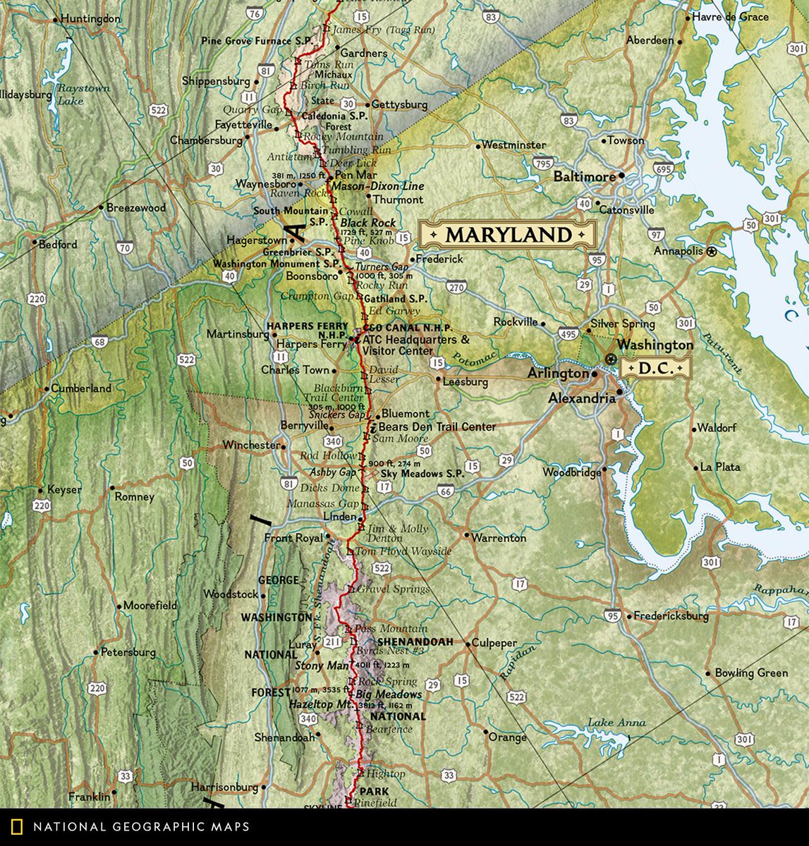
Map of the Day: Proposed by conservationist Benton MacKaye in 1921, the Appalachian Trail stretches more than 2,190 miles throughout 14 states. This Appalachian Trail wall map highlights the entire route from Georgia to Maine. https://t.co/zSQIjVjCOS #MapOTD #AppalachianTrail


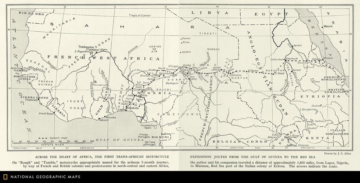
Map of the Day: This map shows the route of a motorcycle expedition featured in the January 1934 issue of National Geographic. The expedition took 5 months, totaling around 3,800 miles through the middle of the African continent. #MapOTD
Map of the Day: This sketch map of Africa depicts the political divisions of the continent in May of 1896. #MapOTD

Map of the Day: For dramatic comparison, in February 1969 National Geographic cartographers mapped a slice of the American West next to an equal-size area of the moon. The comparison reveals that the moon crater Copernicus is roughly the size of Yellowstone National Park. #MapOTD

Map of the Day: This view of Mars is a mosaic comprising thousands of photographic images. The true-color map from November 2016 shows what astronauts would see approaching the red planet from Earth—including jagged valleys, craggy slopes, craters, and polar ice caps. #MapOTD

Map of the Day: This physical map of Asia appeared in the September 1905 issue of National Geographic magazine. #MapOTD

Map of the Day: Antarctica’s ice is thinning as accelerating glaciers spill ice into the sea more quickly than it can be replaced with new snow. This map appeared in the January 2012 issue. #MapOTD

Map of the Day: Some 8,200 years ago, a catastrophic release of water from a North American glacial lake and a tsunami from a submarine landslide off Norway inundated whatever remained of Doggerland. "The Europe That Was" appeared in the December 2012 issue. #MapOTD

Map of the Day: This historic map of Yellowstone and Grand Teton appeared in the February 1989 issue. #MapOTD https://t.co/GyUTigYYsi

Map of the Day: China became, about 6500 B.C., one of the first regions to domesticate crops and animals, sustaining a population that has grown into Earth's largest. This map appeared as a supplement to the May 2008 issue of National Geographic. #MapOTD https://t.co/pbDzKIizBU

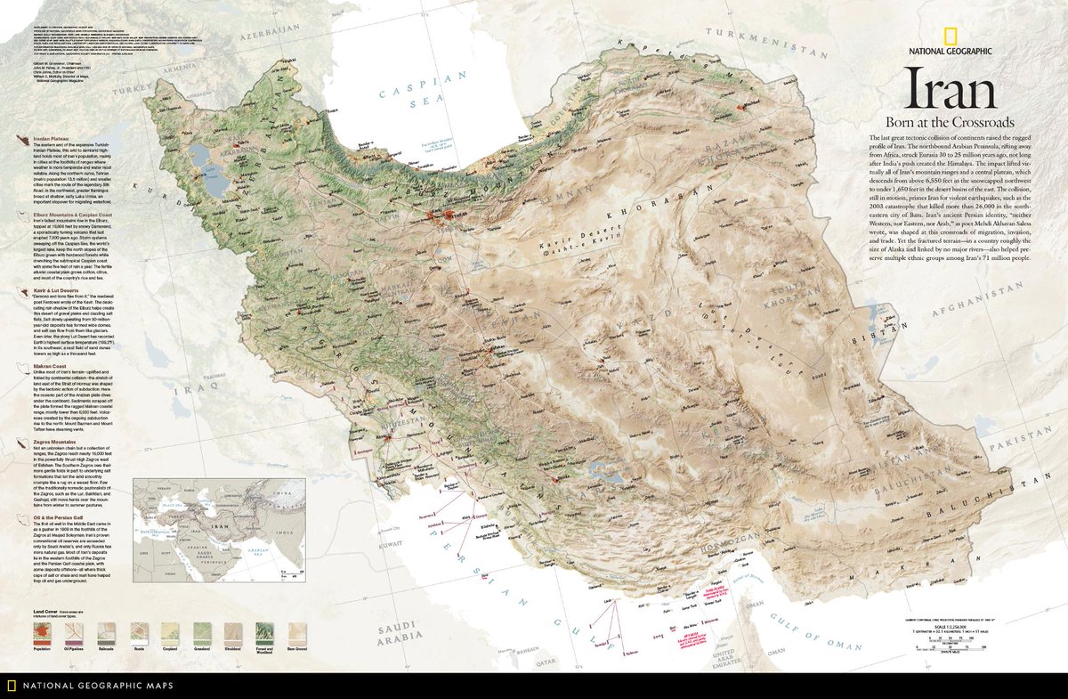
Map of the Day: The last great tectonic collision of continents raised the rugged profile of Iran, highlighted in this August 2008 map. Iran’s ancient Persian identity was shaped at a crossroads of migration, invasion, and trade. #MapOTD https://t.co/uRijhlP0Zr
Map of the Day: The Arctic Ocean Floor, published in October 1971, was based on the bathymetric studies of Marie Tharp and Bruce C. Heezen. #MapOTD https://t.co/R9tMQAMiFF

Map of the Day: Monarchs migrate up to 3,000 miles each fall to their wintering area in central Mexico. From 2010 to 2013, citizen scientists recorded a sharp drop in the number making the trip. #MapOTD

Map of the Day: American forests tell the history—and likely future—of human habitation. This September 2012 map details the biomass and carbon stock of the lower 48. #MapOTD

Map of the Day: Published in February 1960, this map highlights Abraham Lincoln's travels across the United States. #MapOTD

Map of the Day: Published in June 1953, this map shows the thirteen original states with major campaigns of the Revolutionary War. This chart was based the Mitchell Map of 1755. #MapOTD

Last Seen Hashtags on Sotwe
ebonyporn
Seen from Australia
女上位
Seen from United States
bagetsjabol
Seen from Philippines
BirdsOfTwitter
Seen from United States
TapoOut
Seen from United Kingdom
grinding
Seen from Chile
momson videos,
Seen from Belgium
famososnu
Seen from Brazil
รับงานสันกำแพง
Seen from Thailand
illancto
Seen from France
Trends for you
Most Popular Users

Elon Musk 
@elonmusk
240.7M followers

Barack Obama
@barackobama
119.2M followers

Donald J. Trump
@realdonaldtrump
111.7M followers

Cristiano Ronaldo
@cristiano
110.8M followers

Narendra Modi
@narendramodi
107M followers

Rihanna
@rihanna
97.7M followers

NASA
@nasa
92.2M followers

Justin Bieber
@justinbieber
90.9M followers

KATY PERRY
@katyperry
87.7M followers

Taylor Swift
@taylorswift13
81.6M followers

Lady Gaga
@ladygaga
73.1M followers

Virat Kohli
@imvkohli
70M followers

Kim Kardashian
@kimkardashian
69.8M followers

YouTube
@youtube
68.7M followers

Bill Gates
@billgates
63.9M followers

Neymar Jr
@neymarjr
62.8M followers

The Ellen Show
@theellenshow
62.4M followers

CNN
@cnn
61.9M followers

Selena Gomez
@selenagomez
60.8M followers

X
@x
60.8M followers