

#NOUL Etiketinde En Popüler Paylaşımlar

𝗕𝗔𝗚𝗬𝗢𝗡𝗚 𝗞𝗜𝗬𝗔𝗣𝗢, 𝗧𝗨𝗠𝗔𝗧𝗔𝗪𝗜𝗗 𝗡𝗔 𝗦𝗔 𝗘𝗫𝗧𝗥𝗘𝗠𝗘 𝗡𝗢𝗥𝗧𝗛𝗘𝗥𝗡 𝗟𝗨𝗭𝗢𝗡⚠️
Ramdam na ang masungit na panahon sa Extreme Northern Luzon dahil sa pagtawid ng lumalakas na Tropical Storm #KiyapoPH (#Noul). May mga pag-ulan pa rin sa malaking bahagi ng bansa ngayong gabi dahil sa #habagat.
𝗞𝗔𝗦𝗔𝗟𝗨𝗞𝗨𝗬𝗔𝗡𝗚 𝗜𝗠𝗣𝗢𝗥𝗠𝗔𝗦𝗬𝗢𝗡:
⬩𝗟𝗼𝗸𝗮𝘀𝘆𝗼𝗻 𝗻𝗴 𝘀𝗲𝗻𝘁𝗿𝗼 (4:00 PM): Coastal waters of Calayan, Cagayan
⬩𝗟𝗮𝗸𝗮𝘀 𝗻𝗴 𝗵𝗮𝗻𝗴𝗶𝗻 𝗺𝗮𝗹𝗮𝗽𝗶𝘁 𝘀𝗮 𝗴𝗶𝘁𝗻𝗮: 85 km/h
⬩𝗣𝗮𝗴𝗯𝘂𝗴𝘀𝗼: 115 km/h
⬩𝗞𝗮𝘀𝗮𝗹𝘂𝗸𝘂𝘆𝗮𝗻𝗴 𝗽𝗮𝗴𝗸𝗶𝗹𝗼𝘀: West Northwestward at 20 km/h
𝗘𝗣𝗘𝗞𝗧𝗢 𝗡𝗚𝗔𝗬𝗢𝗡𝗚 𝗔𝗥𝗔𝗪:
🌧️ 𝗠𝗔𝗟𝗔𝗟𝗔𝗞𝗔𝗦 𝗡𝗔 𝗣𝗔𝗚-𝗨𝗟𝗔𝗡:
🌀 𝗗𝗮𝗵𝗶𝗹 𝘀𝗮 𝗯𝗮𝗴𝘆𝗼𝗻𝗴 𝗞𝗜𝗬𝗔𝗣𝗢:
🟠 𝗛𝗲𝗮𝘃𝘆-𝗜𝗻𝘁𝗲𝗻𝘀𝗲 𝗥𝗮𝗶𝗻𝘀: Cagayan, Apayao, and Ilocos Norte
🟡 𝗠𝗼𝗱𝗲𝗿𝗮𝘁𝗲-𝗛𝗲𝗮𝘃𝘆 𝗥𝗮𝗶𝗻𝘀: Batanes, Isabela, Kalinga, Abra, Benguet, Ilocos Sur, and La Union
🌬️ 𝗗𝗮𝗵𝗶𝗹 𝘀𝗮 𝗵𝗮𝗯𝗮𝗴𝗮𝘁:
🟡 𝗠𝗼𝗱𝗲𝗿𝗮𝘁𝗲-𝗛𝗲𝗮𝘃𝘆 𝗥𝗮𝗶𝗻𝘀: Zambales, Occidental Mindoro, Palawan, Antique, Iloilo, Guimaras, and Negros Occidental
💨 𝗠𝗔𝗟𝗔𝗟𝗔𝗞𝗔𝗦 𝗡𝗔 𝗕𝗨𝗚𝗦𝗢 𝗡𝗚 𝗛𝗔𝗡𝗚𝗜𝗡:
🌀 𝗗𝗮𝗵𝗶𝗹 𝘀𝗮 𝗯𝗮𝗴𝘆𝗼𝗻𝗴 𝗞𝗜𝗬𝗔𝗣𝗢:
🟨 𝗠𝗮𝗹𝗮𝗸𝗮𝘀 𝗵𝗮𝗻𝗴𝗴𝗮𝗻𝗴 𝘀𝗮 𝗺𝗶𝗻𝘀𝗮𝗻𝗴 𝗺𝗮𝗽𝗮𝗺𝗶𝗻𝘀𝗮𝗹𝗮𝗻𝗴 𝗵𝗮𝗻𝗴𝗶𝗻: Batanes at northern portions ng Ilocos Norte at Cagayan
🟦 𝗞𝗮𝘁𝗮𝗺𝘁𝗮𝗺𝗮𝗻 𝗵𝗮𝗻𝗴𝗴𝗮𝗻𝗴 𝘀𝗮 𝗺𝗮𝗹𝗮𝗸𝗮𝘀 𝗻𝗮 𝗵𝗮𝗻𝗴𝗶𝗻: The rest of mainland Cagayan, Isabela, Nueva Vizcaya, Quirino, Apayao, Abra, Kalinga, Mountain Province, Ifugao, Benguet, the rest of Ilocos Norte, Ilocos Sur, La Union, and the northern and central portions of Aurora
🌬️ 𝗗𝗮𝗵𝗶𝗹 𝘀𝗮 𝗵𝗮𝗯𝗮𝗴𝗮𝘁:
🟦 𝗞𝗮𝘁𝗮𝗺𝘁𝗮𝗺𝗮𝗻 𝗵𝗮𝗻𝗴𝗴𝗮𝗻𝗴 𝘀𝗮 𝗺𝗮𝗹𝗮𝗸𝗮𝘀 𝗻𝗮 𝗵𝗮𝗻𝗴𝗶𝗻: Malaking bahagi ng bansa
☔ Makulimlim at may ilang mga pag-uulan din sa malaking bahagi pa ng Central-Southern Luzon, Metro Manila, Visayas, at Mindanao, dahil sa habagat at malawak na sirkulasyon ng bagyo.
𝗠𝗚𝗔 𝗗𝗔𝗣𝗔𝗧 𝗠𝗔𝗟𝗔𝗠𝗔𝗡:
📌 Ang 𝘀𝗲𝗻𝘁𝗿𝗼 𝗻𝗴 𝗧𝗿𝗼𝗽𝗶𝗰𝗮𝗹 𝗦𝘁𝗼𝗿𝗺 𝗞𝗜𝗬𝗔𝗣𝗢 𝗮𝘆 𝘁𝗶𝗻𝗮𝘁𝗮𝘄𝗶𝗱 𝗻𝗮 𝗮𝗻𝗴 𝗕𝗮𝗯𝘂𝘆𝗮𝗻 𝗜𝘀𝗹𝗮𝗻𝗱𝘀 at ang malawak na sirkulasyon nito ay nagpapaulan na sa malaking bahagi ng Northern Luzon.
🧭 Ang bagyo ay inaasahang patuloy na kikilos pa-hilagang kanluran at 𝗶𝗻𝗮𝗮𝘀𝗮𝗵𝗮𝗻𝗴 𝗺𝗮𝗸𝗮𝗸𝗮𝗹𝗮𝗯𝗮𝘀 𝘀𝗮 𝗪𝗲𝘀𝘁 𝗣𝗵𝗶𝗹𝗶𝗽𝗽𝗶𝗻𝗲 𝗦𝗲𝗮 𝗻𝗴𝗮𝘆𝗼𝗻𝗴 𝗴𝗮𝗯𝗶 at tutumbukin ang southern China sa weekend.
🔺 Inaasahang lalakas pa ang bagyo at 𝗽𝗼𝘀𝗶𝗯𝗹𝗲𝗻𝗴 𝗺𝗮𝗴𝗶𝗻𝗴 𝗧𝗬𝗣𝗛𝗢𝗢𝗡 𝗽𝗮𝗴𝗸𝗮𝗹𝗮𝗴𝗽𝗮𝘀 𝘀𝗮 𝗘𝘅𝘁𝗿𝗲𝗺𝗲 𝗡𝗼𝗿𝘁𝗵𝗲𝗿𝗻 𝗟𝘂𝘇𝗼𝗻 𝗯𝘂𝗸𝗮𝘀.
⚠️🌧️💨 Ang bagyo ay inaasahang magdudulot pa rin ng hanggang sa matinding ulan at pabugsu-bugsong malakas na hangin sa Northern Luzon, partikular sa 𝗖𝗮𝗴𝗮𝘆𝗮𝗻, 𝗔𝗽𝗮𝘆𝗮𝗼, 𝗔𝗯𝗿𝗮, 𝗜𝗹𝗼𝗰𝗼𝘀 𝗡𝗼𝗿𝘁𝗲, 𝗮𝘁 𝗜𝗹𝗼𝗰𝗼𝘀 𝗦𝘂𝗿 ngayong gabi hanggang bukas.
𝗘𝗣𝗘𝗞𝗧𝗢 𝗦𝗔 𝗛𝗔𝗕𝗔𝗚𝗔𝗧:
Mahina man, inaasahang patuloy na hahatakin ng bagyong KIYAPO ang habagat (southwest monsoon) na magdudulot ng 𝗺𝗮𝘂𝗹𝗮𝗻 𝗮𝘁 𝗺𝗮𝗵𝗮𝗻𝗴𝗶𝗻𝗴 𝗽𝗮𝗻𝗮𝗵𝗼𝗻 𝘀𝗮 𝗺𝗮𝗹𝗮𝗸𝗶𝗻𝗴 𝗯𝗮𝗵𝗮𝗴𝗶 𝗻𝗴 𝗯𝗮𝗻𝘀𝗮 𝗵𝗮𝗻𝗴𝗴𝗮𝗻𝗴 𝘀𝗮 𝘄𝗲𝗲𝗸𝗲𝗻𝗱.
🌬️ Halos buong bansa ang inaasahang makakaranas ng mahangin na panahon hanggang bukas.
🌧️ Ang 𝗵𝗮𝗯𝗮𝗴𝗮𝘁 (𝘀𝗼𝘂𝘁𝗵𝘄𝗲𝘀𝘁 𝗺𝗼𝗻𝘀𝗼𝗼𝗻) 𝗻𝗮𝗺𝗮𝗻 𝗮𝘆 𝗽𝗮𝘁𝘂𝗹𝗼𝘆 𝗻𝗮 𝗺𝗮𝗴𝗱𝘂𝗱𝘂𝗹𝗼𝘁 𝗻𝗴 𝗺𝗮𝘂𝗹𝗮𝗻𝗴 𝗽𝗮𝗻𝗮𝗵𝗼𝗻 sa:
➡️ Kanlurang bahagi ng Luzon sa weekend
𝗣𝗔𝗥𝗔 𝗦𝗔 𝗠𝗘𝗧𝗥𝗢 𝗠𝗔𝗡𝗜𝗟𝗔: 𝗗𝗮𝗵𝗶𝗹 𝘀𝗮 𝗲𝗽𝗲𝗸𝘁𝗼 𝗻𝗴 𝗵𝗮𝗯𝗮𝗴𝗮𝘁, 𝗶𝗻𝗮𝗮𝘀𝗮𝗵𝗮𝗻𝗴 𝗺𝗮𝗸𝘂𝗹𝗶𝗺𝗹𝗶𝗺 𝗮𝘁 𝗺𝗮𝘆 𝗯𝗮𝗻𝘁𝗮 𝗽𝗮 𝗿𝗶𝗻 𝗻𝗴 𝗺𝗮𝗹𝗮𝗹𝗮𝗸𝗮𝘀 𝗻𝗮 𝗺𝗴𝗮 𝗽𝗮𝗴-𝘂𝗹𝗮𝗻 𝗮𝘁 𝗽𝗮𝗯𝘂𝗴𝘀𝘂-𝗯𝘂𝗴𝘀𝗼𝗻𝗴 𝗵𝗮𝗻𝗴𝗶𝗻 𝗻𝗴𝗮𝘆𝗼𝗻𝗴 𝗴𝗮𝗯𝗶 𝗵𝗮𝗻𝗴𝗴𝗮𝗻𝗴 𝘀𝗮 𝗦𝗮𝗯𝗮𝗱𝗼 (𝗝𝘂𝗹𝘆 𝟮𝟰-𝟮𝟱).
ℹ️ Manatiling updated sa posibleng mga epekto ng bagyo at habagat. Ingat po!
𝗧𝗥𝗢𝗣𝗜𝗖𝗔𝗟 𝗖𝗬𝗖𝗟𝗢𝗡𝗘 𝗨𝗣𝗗𝗔𝗧𝗘
𝗦𝗰𝗶𝗲𝗻𝗰𝗲𝗞𝗼𝗻𝗲𝗸
5:00 PM | 24 July 2026


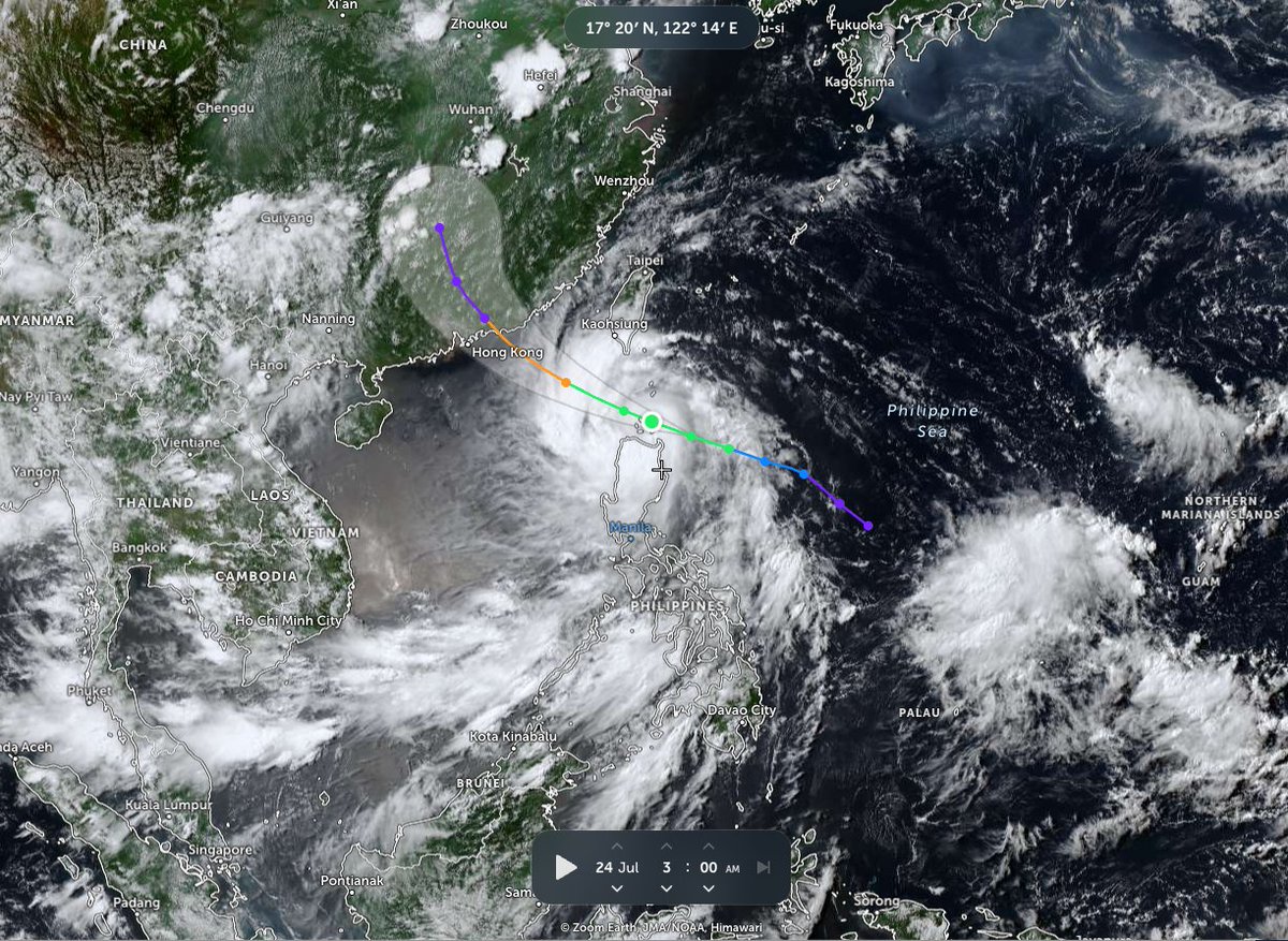
TS #NOUL is moving briskly through Babuyan Islands of N #Philippines. System is nicely organized & likely to become #typhoon as it crosses South China Sea. Landfall will happen late Sat or early Sun, possibly near #HongKong (star), so folks there should watch NOUL closely.


All train services in #GuangdongProvince will be suspended by Sunday as #TyphoonNoul approaches the coast, railway authorities announced.
The meteorological department forecasts that #Noul, the 12th typhoon of the year, will make landfall along the coast of Lufeng, bringing severe thunderstorms and strong gales to the region.
To ensure passenger safety, the China Railway Guangzhou Group said it will begin gradually suspending high-speed and regular train services on Saturday. By Sunday, all train operations within the province are expected to be halted.
Passengers are advised to check the official 12306 railway website or mobile app for specific train cancellations and ticketing updates. Stay safe and adjust your travel plans accordingly!

#Shenzhen is expected to experience heavy to torrential #rainfall from Saturday night through Sunday night as #TyphoonNoul approaches South China.
The Central Meteorological Observatory issued an orange typhoon warning at 6 a.m. today, after the tropical depression east of the Philippines intensified into this year's 12th typhoon. Maximum wind speeds near its center have reached Force 8 (tropical storm strength).
Noul is forecast to move west-northwest at a speed of 25–30 km/h and gradually intensify. It is expected to enter the northeastern part of the South China Sea between tonight and early tomorrow morning, then approach the coast of Guangdong and Fujian. Stay safe and alert!



#Tropical #Pacific_West #Noul #98W and possible others.ECMWF 23/1800UTC animation (https://t.co/TjRNezW40A)
#Tropical #Pacific_West #Noul #98W and possible others. GFS accumulated precipitation 24/0001UTC animation (https://t.co/TjRNezW40A)
#Tropical #Pacific_West #Noul #98W and possible others. GFS 24/0001UTC animation (https://t.co/TjRNezW40A)
#Tropical #Pacific_West #Noul #98W and possible others. HFSA accumulated precipitation 24/0001UTC animation (https://t.co/TjRNezW40A)
#Tropical #Pacific_West #Noul #98W and possible others. Image 24/05UTC with 24/0001UTC tracks ensembles GEFS 24/0001UTC and ECMWF 23/1800UTC
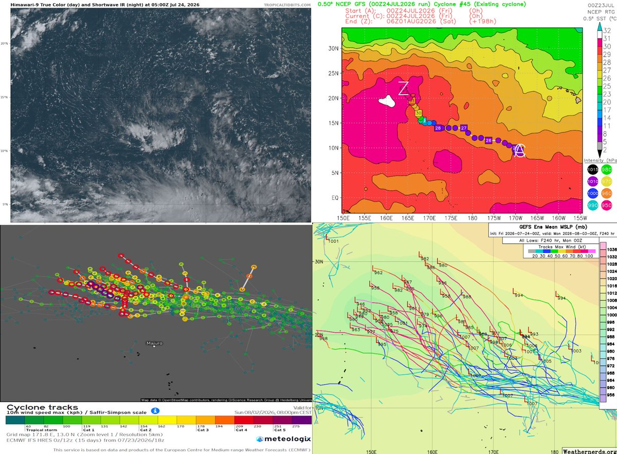


#Tropical #Pacific_West #Noul #98W and possible others. Area image 24/03-06UTC, 24 hour rain accumulation 24/05UTC, 24/0001UTC tracks and GFS 6 and 10 days.


Tropical Storm #Noul has maximum sustained winds of 45mph with wind gusts of 60mph and a minimum central pressure of 996mbars and it is moving west northwest at 18mph. It is still being forecasted to peak as a 90mph typhoon with wind gusts of 115mph before it makes landfall in China #tropicalstorm #BREAKING #tropicswx #tropicalupdate #rainfall #wind #severewx #wxtwitter #flooding


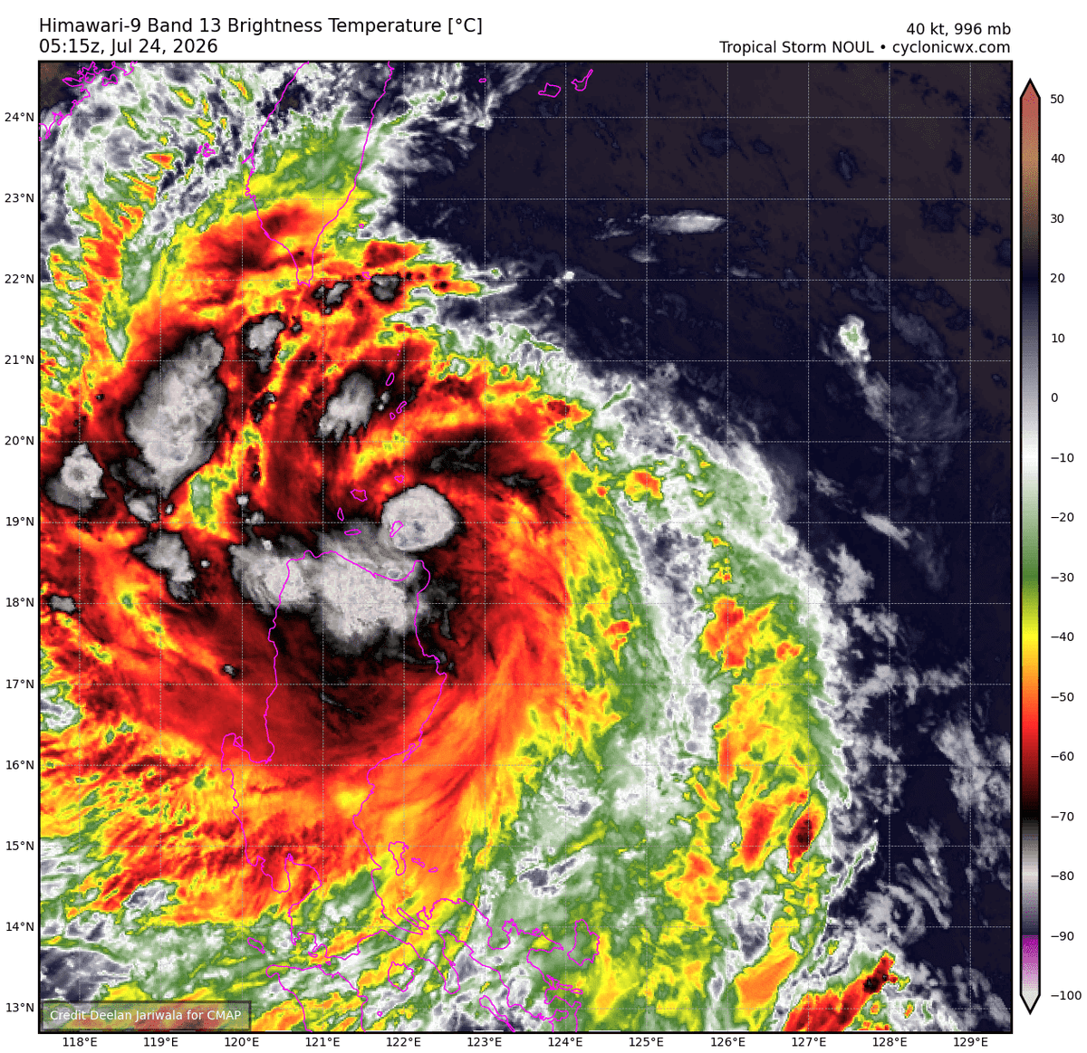
#Noul looks solid tonight as healthy convection and outflow is fanning out (particularly in the W quadrant) Still some moderate sub-outflow layer shear, but its forecast to relax soon and could allow for a window of quick intensification. HAFS prob isnt handling it too well.


🌀🌀 #KiyapoPH / #Kiyapo / #NOUL 🌀
🌀 TYPHOON Alert
Issued: July 24, 2026
Official agencies including PAGASA, JTWC, and JMA are currently classifying KIYAPO-PH / NOUL as a 45–50 knot TROPICAL STORM. However, satellite imagery indicates that a well-defined eye has developed, suggesting that the system has likely intensified into a TYPHOON.
A TYPHOON ALERT is now in effect for northern Luzon, including the Batanes Islands and Babuyan Islands, where dangerous weather conditions are already occurring.
All residents across northern Luzon, the Batanes Islands, and the Babuyan Islands are urged to SHELTER IN PLACE immediately and remain sheltered until local authorities determine that conditions are safe. Do not venture outdoors during the most dangerous phase of the storm, as destructive winds and life-threatening conditions may occur.
🌀 Expected and ongoing hazards include:
- 🌀 TYPHOON-force winds of 125–140 km/h, with stronger gusts possible.
- 🌧️ Torrential tropical rain squalls producing periods of intense rainfall and the potential for widespread flash flooding.
- 🌊 Dangerous surf and life-threatening coastal conditions affecting exposed shorelines.
- 🌊 Storm surge of approximately 1–3 meters, with isolated areas potentially experiencing 2–4 meters of inundation.
- ⛰️ Extensive coastal, inland, and highland flooding, with an increased risk of landslides in mountainous areas.
The combination of powerful winds, heavy tropical rainfall, dangerous seas, and storm surge could create hazardous to life-threatening conditions throughout the affected regions.
Everyone within the warning areas should continue monitoring official advisories from PAGASA, JTWC, and JMA, follow all instructions from local emergency officials, and remain sheltered until the storm has completely passed.
Respectfully,
Roshin Rowjee
Hurricane/Typhoon/Cyclone Updates & Information 🌀


🚨🌧️ WEATHER ALERT ⚠️ China has issued heavy rain and flood warnings as Tropical Storm #Noul approaches the southern coast. Authorities are on high alert as the storm is expected to strengthen over the weekend. Stay informed and stay safe. 🌊 #China #WeatherAlert #TropicalStorm


The western Pacific Ocean is still active with Tropical Storm #Noul near the Philippines and disturbances/storm systems producing light to moderate to heavy rainfall and gusty to damaging winds #flooding #BREAKING #severewx #wxtwitter #wind #rainfall #tropicswx #tropicalupdate #tropicalstorm


🌀🇭🇰 TROPICAL CYCLONE #NOUL (#KIYAPOPh) | 1210 FRIDAY 24-JUL-2026 | 📷 HKO
Welcome to the 8.5-hour long pre-#T1... 🫠
#HKWEATHER
https://t.co/nKMv4N2jg7
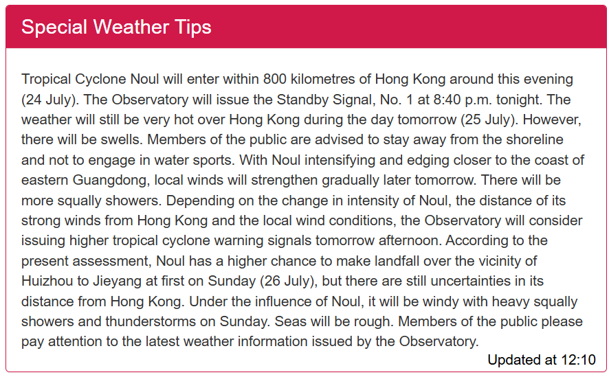

[天氣提示]7月24日 12:10PM:熱帶氣旋紅霞會在今日(7月24日)黃昏前後進入本港800公里範圍,天文台會在今晚8時40分發出一號戒備信號。
明日(7月25日)日間本港... https://t.co/CA4pfRdy92
Sotwe'de En Son Görülen Etiketler
monkeyapp #ometv
Son görüldüğü yer United States
gaydaddy
หารุกควยใหญ่
Son görüldüğü yer Thailand
ometv
Son görüldüğü yer Germany
NayantharaHot
短剧
Son görüldüğü yer Vietnam
TeoDen
Son görüldüğü yer Turkey
desigay
Son görüldüğü yer Mexico
izmirbayan
Son görüldüğü yer Turkey
adanagay
Son görüldüğü yer Turkey
Senin İçin Trendler
En Popüler Kullanıcılar

Elon Musk 
@elonmusk
241M takipçi

Barack Obama
@barackobama
119.2M takipçi

Cristiano Ronaldo
@cristiano
112M takipçi

Donald J. Trump
@realdonaldtrump
111.8M takipçi

Narendra Modi
@narendramodi
107.1M takipçi

Rihanna
@rihanna
98M takipçi

NASA
@nasa
92.2M takipçi

Justin Bieber
@justinbieber
91.2M takipçi

KATY PERRY
@katyperry
88.4M takipçi

Taylor Swift
@taylorswift13
82.3M takipçi

Lady Gaga
@ladygaga
73.8M takipçi

Virat Kohli
@imvkohli
71.1M takipçi

Kim Kardashian
@kimkardashian
70.2M takipçi

YouTube
@youtube
68.7M takipçi

Bill Gates
@billgates
64.3M takipçi

Neymar Jr
@neymarjr
64M takipçi

The Ellen Show
@theellenshow
62.4M takipçi

CNN
@cnn
61.8M takipçi

Selena Gomez
@selenagomez
61.5M takipçi

X
@x
60.8M takipçi