

Top Tweets for #PRAIRIES

Looking for a great hike this weekend? Fishing? Birding?
If so check out my article, Visit Winding Creek Conservation Area for Spectacular Skies, Great Hiking, Birdwatching & Fishing, to learn more about a great nature spot.
https://t.co/836DMeikis
@discovermccd #prairies #birds

15 seconds of native prairie bliss at Winding Creek Conservation Area in McHenry County. Look for my story about this great nature spot tomorrow. #nativeplants #prairies #illinois

#Occitan Illa oblidada
#Breton Enez ankounac'haet
#Basque Ahaztutako uhartea
Showtimes for Winnipeg’s theatres showing forgotten inland:
#Winnipeg #Manitoba #catholic #Prairies





DreamWorks Animation keeps releasing PEAK this decade.
All three movies are in the studio’s top 10 highest-rated movies on Rotten Tomatoes.

Check out my new article, Lake in the Hills Fen Conservation Area-Dragonflies Galore, Rare Hanging Fens, Great Birdwatching & Big Skies-to learn more about one of my new favorite places to hike.
https://t.co/Mz2vP9D1dB
#fens #prairies #nativeplants #mchenrycountyil @DiscoverMCCD


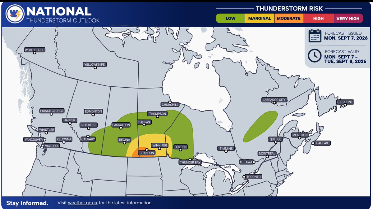
National Storm Outlook — Monday, September 7, 2026 👇
🇨🇦 Happy Labour Day, Canada!
We are monitoring the threat of severe thunderstorms across parts of the Southern #Prairies today. ⛈️
A strong low-pressure system is slowly tracking through the region and will bring heavy rainfall across central and southern Saskatchewan and into central Manitoba.
🌧️ To the south, atmospheric conditions are becoming increasingly favourable for severe thunderstorm development. ⚠️
⏰ Severe thunderstorms are expected to develop during the afternoon hours and continue into the evening. There is a risk that some thunderstorms could develop into supercells, which would increase the potential for more significant severe weather. 🌪️
These thunderstorms will be capable of producing:
🌧️ Heavy rainfall
💨 Strong wind gusts — 90–100 km/h
🧊 Large hail — quarter- to golf-ball-sized
🌪️ An isolated tornado
🌪️ Tornado Risk
The overall tornado risk will remain relatively low today. However, some of the latest weather data is increasingly hinting at a potential tornado threat, especially across SW Manitoba near the international border.
The majority of the tornado threat is expected to remain stateside, but an isolated tornado cannot be ruled out across southern Manitoba.
📊 At this time, we are forecasting a 2–5% chance of tornado development.
⚠️ Once again, this is considered a low tornado risk, but an isolated tornado remains possible, particularly near the international border.
🌩️ Stay weather-aware today and keep up with the latest watches and warnings. Conditions can change quickly, especially if supercell thunderstorms develop.
#CanadaWeather #Prairies #SevereWeather #SevereThunderstorms #Saskatchewan #Manitoba #Alberta #SKStorm #MBStorm #ABStorm #Thunderstorms #Supercell #Tornado #TornadoRisk #WeatherAlert #StormOutlook #CanadianWeather #WeatherAware #LabourDay #LongWeekend

🌩️ National Storm Outlook — Tonight
A round of active weather is expected overnight across parts of the #Prairies 🇨🇦.
We are keeping a close eye on the developing severe thunderstorms across the Prairies this evening. ⛈️ We believe these storms will remain on the severe side and could produce impacts to some areas overnight.
🕚 Effective at 11 PM local time, a Moderate Risk 🟠 and High Risk 🔴 for severe thunderstorm development are forecasted across SE Saskatchewan and SW Manitoba.
These thunderstorms will be capable of producing:
🌧️ Heavy rainfall
💨 Strong wind gusts
🧊 Large hail — quarter- to golf-ball-sized
🌪️ An isolated tornado
🌪️ The tornado threat will be mainly focused across SE Alberta into SW Saskatchewan, as well as SE Saskatchewan and SW Manitoba.
📊 At this time, a 5–20% chance of tornado development is expected across SW Manitoba into SE Saskatchewan.
⚠️ A very low (2%) tornado risk is forecasted for SW Alberta into SE Saskatchewan.
🚨 Stay weather-aware tonight, especially if you live in or are travelling through the areas at risk. Have your notifications on overnight, in case a severe weather alert is issued for your area. 🇨🇦⛈️
#CanadaWeather #Prairies #SevereWeather #SevereThunderstorms #Saskatchewan #Manitoba #Alberta #SKStorm #MBStorm #ABStorm #Thunderstorms #Tornado #TornadoRisk #WeatherAlert #StormOutlook #CanadianWeather #WeatherAware


Des secteurs des Prairies canadiennes doivent s'attendre à une bonne douche. ☔
https://t.co/RDwhRlLxHZ
#meteocanada #prairies #pluie #orages


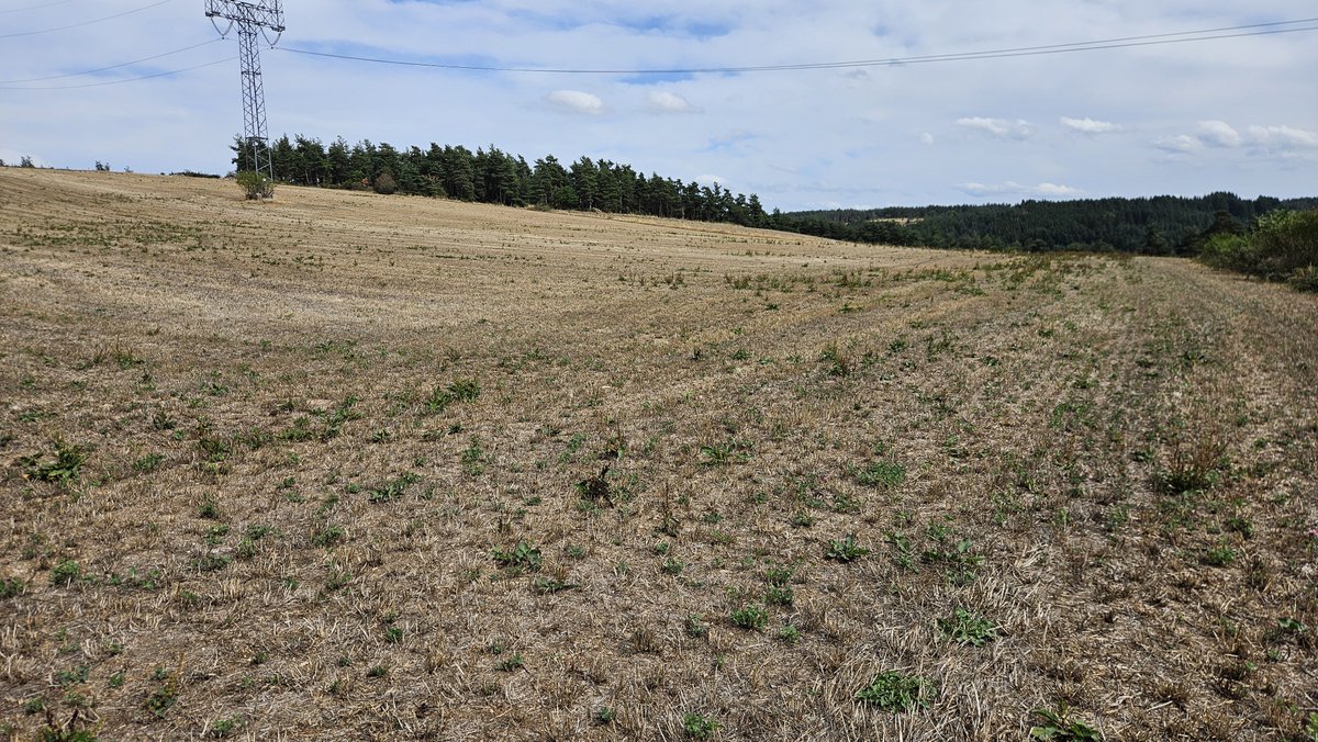

I visited it by chance, and it turned into a great experience. My story is published in Lethbridge Herald recently.
Have a read and share your thoughts 🙏🏼🙏🏼🙏🏼
#Alberta #Foremost #SouthernAlberta #Prairies #LethbridgeHerald


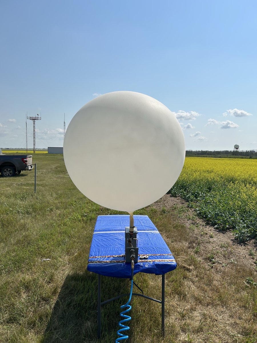
🎈 New in Saskatoon! We have set up a mobile upper air station that launches a weather balloon every weekday this summer to collect valuable data and improve severe weather forecasts across the #Prairies. 🌦️⚡


🍁Canada’s #crops are in their best shape in a decade despite persistent extreme #weather, as a years-long #drought that had left thousands of #farmers across the #Prairies struggling to grow a #crop has eased after abundant spring rains provided enough #moisture for #germination. Warm summer temperatures have since accelerated development, while the 120mn acres of #prairie #farmland produce the world’s largest #canola crop, are often the top source of spring #wheat, and supply much of the global market for smaller crops including #lentils and #mustard
https://t.co/mqoD8UAp0t


Nov 2026 canola futures up +$19.4 to $822.6/MT @ 3-yr high (since July 2023), veg oils rally. #crudeoil rally & #Canada production concerns in parts of #Prairies support. Grains rally also underpin.
@OntAg @FarmsPrairies


The Wheaties are ready to welcome you at @AginMotion today!!🌾 Make sure you stop by booth 107 for your producer ‘Thank You!’ gift and play Wheat Jeopardy for prizes!🥳
#AginMotion2026 #AiM #CdnAg #SaskAg #wheat #farming #producer #prairies

🚨 #UPDATE: Storm Outlook Updated for the #Prairies 🌩️🌪️
We have UPDATED our Storm Outlook for the #Prairies ahead of the severe thunderstorms expected to track across the region late this afternoon and continue through the evening.
We are now forecasting a VERY HIGH RISK of severe thunderstorm development across the #Edmonton area. This is a rare forecast level, indicating that this area has the highest potential for severe thunderstorms capable of producing significant impacts.
A High Risk remains in effect for surrounding areas, extending into parts of Saskatchewan. This includes #Lloydminster, #Camrose, and #Battleford.
🌪️ Tornado Risk:
• 60–70% chance of tornado development across areas east of #Edmonton. This is an exceptionally high and rare forecast level.
• 40–55% chance of tornado development across surrounding areas, including locations west of #Edmonton and near #Lloydminster.
A high impact level is also forecasted for areas near the #Edmonton area and along the Yellowhead Highway between #Edmonton and #Lloydminster.
⏰ Forecast Valid:
4:30 PM MDT/CST – 1:30 AM MDT/CST, Sunday, July 19
We do not typically update our forecasts after publishing a National Storm Outlook. However, rapidly changing atmospheric conditions have become significantly more favourable for severe thunderstorm and tornado development this afternoon and evening. As a result, we believe this forecast update is necessary to reflect the increased risk.
If you are within the risk areas, stay weather-aware, have multiple ways to receive warnings, and be prepared to act quickly if watches or warnings are issued.
#ABStorm #SKStorm #Alberta #Saskatchewan #Edmonton #Lloydminster #Camrose #Battleford #SevereWeather #Thunderstorm #Tornado #StormAlert #WeatherAlert #CanadaWeather 🌩️🌪️


Here is your detailed Storm Outlook for today — Saturday, July 18, 2026 ⛈️👇
There is a risk of strong to severe thunderstorms across parts of #Ontario and the #Prairies today.
We are forecasting a high risk for severe thunderstorm development across both regions this afternoon and evening.
Across the Prairies, the highest risk extends across Southern and Western Saskatchewan, particularly west of #Saskatoon, near the Alberta–Saskatchewan border, and into Eastern Alberta.
The second high risk area is across Southern Ontario, especially for locations near or south of the Highway 401 corridor and along the shorelines of Lake Erie and Lake Ontario. This includes much of the #GTA, as well as areas near #London and #Niagara.
🟠A moderate risk is also forecasted for surrounding areas, including #Saskatoon and #Edmonton across the Prairies, and #Barrie, #Kingston, and #Ottawa in Southern and Eastern Ontario.
Across both high-risk & Moderate risk areas, thunderstorms will have the potential to produce:
• Heavy rainfall 🌧️
• Strong to damaging wind gusts 💨
• Large hail (potentially very large across the Prairies) 🧊
• A few tornadoes 🌪️
A more localized and detailed storm and tornado risk map for the Prairies will be shared later this morning as additional weather data becomes available.
____________________________________
⚠️*Please Note: Wildfire smoke MAY lower the storm potential across Eastern Ontario on Saturday
Which is why we have left out the 'high risk' category across the area at this time. If anything changes, the area may get placed under a high severe storm development risk area.*
Stay tuned!
Stay weather-aware throughout the day and be prepared for watches and warnings if you are in or near the risk areas.
#ONStorm #SKStorm #ABStorm #Prairies #SevereWeather #Thunderstorm #StormWatch #Tornado #Hail #WeatherAlert #CanadaWeather 🌩️🌪️


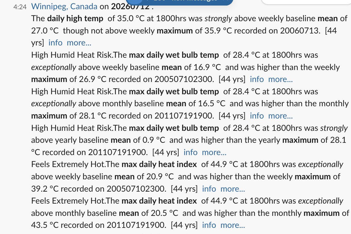
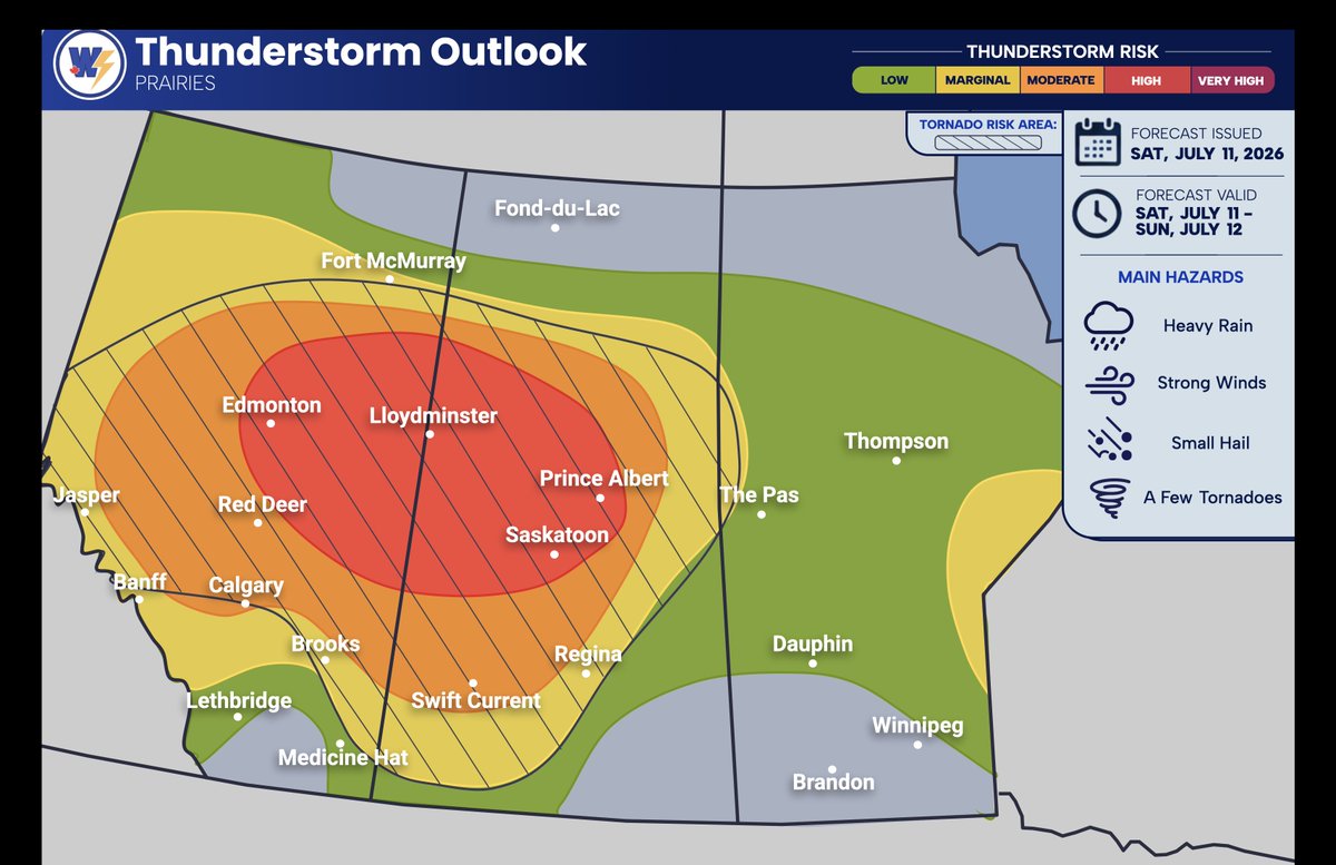
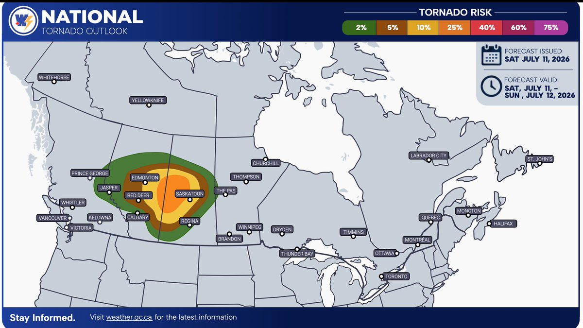
Storm Outlook for today - Saturday, July 11, 2026 👇
After a very active day of severe weather across parts of the #Prairies yesterday, another round of severe thunderstorms is expected today across many of the same areas that have been impacted over the past several days.
🚨 We are forecasting a HIGH RISK for severe thunderstorm development across parts of Central Saskatchewan and Central Alberta, including #Edmonton, #Saskatoon, #PrinceAlbert, and #Lloydminster.
⚠️ A MODERATE RISK is in place for surrounding areas, including #RedDeer, #Calgary, and #SwiftCurrent.
These storms will be capable of producing:
🌧️ Heavy rainfall
💨 Damaging wind gusts
🧊 Very large hail (quarter to tennis ball-sized)
🌪️ A few tornadoes, with the potential for a tornado outbreak
A second area of severe thunderstorms is expected across extreme eastern Manitoba into NW Ontario.
Elsewhere, non-severe thunderstorms are possible across parts of Atlantic Canada, the Yukon, and the NWT.
🌪️ Tornado Risk: Conditions appear highly favourable for tornado development across Alberta and Saskatchewan today. We are forecasting a 10–35% chance of tornado development, with the greatest risk across the High Risk area.
👉If conditions continue to become more favourable, the tornado risk may be increased to 40–55%, depending on how the atmosphere evolves throughout the day.
Stay tuned for further updates, and stay safe if you are in the affected areas. Continue to monitor the latest forecasts, and follow all watches and warnings issued by @environmentca.
#ABstorm #SKstorm #MBstorm #ONstorm #ABwx #SKwx #MBwx #ONwx #SevereWeather #Tornado #StormOutlook



Intéressant: planter des #arbres ne suffit pas à enrayer l'effondrement de la #biodiversité. En Europe, les #prairies et l'élevage #herbager jouent un rôle tout aussi crucial dans la préservation d'une biodiversité d'une richesse exceptionnelle ... à condition d'y mener un système d'agriculture à Haute Valeur Naturelle 📷 peu ou pas d'intrants, "mécanisation limitée", savoir-faire dans l’exploitation des agrosystèmes) https://t.co/QKA61uFdv1
#canola higher as #soyoil regains its mojo. #StatsCanada cut new crop canola 26/27 ending stocks to 1.306 MMT from 1.319 last on lower beginning stocks (bigger old crop exports). Erratic rain expected across #Prairies, drier weather needed.
@OntAg @FarmsNews @FarmsPrairies

Last Seen Hashtags on Sotwe
latina
Seen from United States
Pirates
Seen from Philippines
minichat(((**))) filter:native_video since:2026-09-9
Seen from United States
anxiouspanda
Seen from Brazil
monkeyapp nolimit filter:videos
Seen from United States
cumtribute
Seen from New Zealand
margovonteese
Seen from France
ebonytaboo
Seen from France
omegle
Seen from Korea
teenageee
Seen from Brazil
Most Popular Users

Elon Musk 
@elonmusk
241.8M followers

Barack Obama
@barackobama
119M followers

Cristiano Ronaldo
@cristiano
114.6M followers

Donald J. Trump
@realdonaldtrump
111.9M followers

Narendra Modi
@narendramodi
107.2M followers

Rihanna
@rihanna
98.7M followers

NASA
@nasa
92.4M followers

Justin Bieber
@justinbieber
91.8M followers

KATY PERRY
@katyperry
90.1M followers

Taylor Swift
@taylorswift13
84M followers

Lady Gaga
@ladygaga
75.5M followers

Virat Kohli
@imvkohli
73.5M followers

Kim Kardashian
@kimkardashian
70.9M followers

YouTube
@youtube
68.8M followers

Neymar Jr
@neymarjr
66.5M followers

Bill Gates
@billgates
65.3M followers

Selena Gomez
@selenagomez
63.1M followers

The Ellen Show
@theellenshow
62.3M followers

CNN
@cnn
61.8M followers

X
@x
60.7M followers