Top Tweets for #RapidScan

Investigating kinetics with Bruker’s #RapidScan accessory often requires light irradiation to trigger chemical reactions. The RapidScan resonator includes a dedicated adapter to couple laser light directly into it.
Learn more: https://t.co/o9tO7uuwAS
#Bruker #EPR #EPRchat


Field-domain rapid-scan EPR at 240 GHz for studies of protein functional dynamics at room temperature #EPR #RapidScan https://t.co/raSJLxQmgH

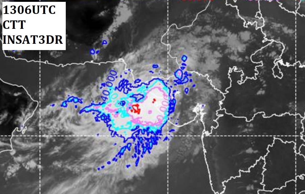
At 1115IST, SCS #Rimal.
इसके लगभग उत्तर की ओर बढ़ने, और तेज होने और आज, आधी रात तक एक गंभीर चक्रवाती तूफान के रूप में मोंगला (बांग्लादेश) के दक्षिण-पश्चिम के करीब सागर द्वीप और खेपुपारा के बीच बांग्लादेश और आसपास के पश्चिम बंगाल तटों को पार करने की बहुत संभावना है।
#rapidscan
SCS #Remal 🌀 rainfall from INSAT3DR 🛰️ rapid scan at 0945/05/26.
Every minute details about the associated convection through the #rapidscan mode helps in detecting the anticipated distribution of convection and expected squally, gale wind & associated rainfall.
Red: 27-35 mm/h
#INSAT3DR🛰️#RapidScan (at every 4:30 min) has now started to track the cyclone #Remal as you can see Intense convection rotating with cloud bands observed at 1950IST/05/25.
@WMO @CopernicusEU @eumetsat @UWCIMSS

InfraRed #RAPIDSCAN of #CycloneMichaung at 22:30IST/12/03. Multiple mesovortices can be seen in great detail by rapid scans. Study found that increasing BT in the eye of a TC is a good indicator of TC intensification. #INSAT3DR 🛰️
More on https://t.co/WfQWJ7k2G1
#MichaungStorm
SCS #HamoonCyclone at 2200IST/10/24 from #rapidscan #INSAT3DR 🛰️.
Landfall process likely to commence from midnight of today. #IMD
#Bangladesh #Hamoon
#INSAT3DR #RapidScan tracking the SCS #Hamoon as you can see Intense convection rotating with cloud bands seen from (IR+Visible) band at 1030IST/10/24. Likely to intensify into VSCS. #IMD
#Bangladesh
VSCS #biporjoycyclone approching land. Study found that #RapidScan operations at every 4 min, is even sometime better than that of Weather Radars in terms of scanning rate of temporal resolution of 10minutes.
More on landfall pl visit https://t.co/WfQWJ7k2G1
#CycloneBiporjoy
#CycloneBiparjoy is approaching the coastlines of western India&southern Pakistan after churning in the Arabian Sea for more than a week as capturing by VIS+IR #RAPIDSCAN INSAT3DR at 1130IST/06/15.Warm sea surface temperatures have contributed to cyclone’s unusually long lifespan
VSCS #CycloneBiparjoy at 1415IST/06/13. #RAPIDscan image data could aid in the recognition of weakening or intensifying trends during lack of texture of cyclones,variation of internal structure in terms of eye & eye wall characterization, associated convection &precipitation.
Every minute details about the associated convection through the #rapidscan (#INSAT3DR🛰️)mode helps in detecting the anticipated distribution of convection and expected squally, gale wind and associated rainfall. #BiparjoyCyclone #CycloneBiparjoy
https://t.co/yA9BDRzMNb
ESCS #BiparjoyCyclone at 1700IST/06/12. https://t.co/WfQWJ7k2G1
#INSAT3DR #RAPIDSCAN #Visible #Gujaratcyclone #Gujarat
ESCS #BiparjoyCyclone:Intense convection rotating with cloud bands as seen from Visible #RapidScan #INSAT3DR🛰️ at 1330IST/06/12 as #CycloneBiparjoy to cross near Jakhau Port (#Gujarat) by noon of 15th June as VSCS. https://t.co/WfQWJ7k2G1
#Gujaratcyclone #saurashtra #Kutch
Bands of heavy convective showers that spiral inward toward the #Biparjoy center along with ring of intense cumulonimbus clouds can be seen from Visible #Rapidscan at 10:15IST/06/8.
VSCS #CycloneBiporjoy will move N-NWards. #IMD
#Oman #Biparjoy_cyclone #CycloneAlert
Very high reflectance (>73%) indicating strong convection seen across the bands of SCS #BiparjoyCyclone from visible #Rapidscan INSAT3DR 🛰️ at 1400IST/06/07 as it is likely to move nearly northwards and intensify into VSCS during next 12 hrs. https://t.co/WfQWJ7k2G1
#cyclone
#INSAT3DR🛰️#RapidScan (at every 4:30 min) has now started to track the SCS #BiparjoyCyclone as you can see Intense convection rotating with cloud bands as seen from Visible band at 1030IST/06/07. Likely to move nearly northwards and intensify into VSCS during next 24 hrs. #IMD

Las #tormentas de la #RegióndeMurcia vistas por el satélite #MSG de @eumetsat.
#RapidScan entre las 12:45 y las 15:20h.

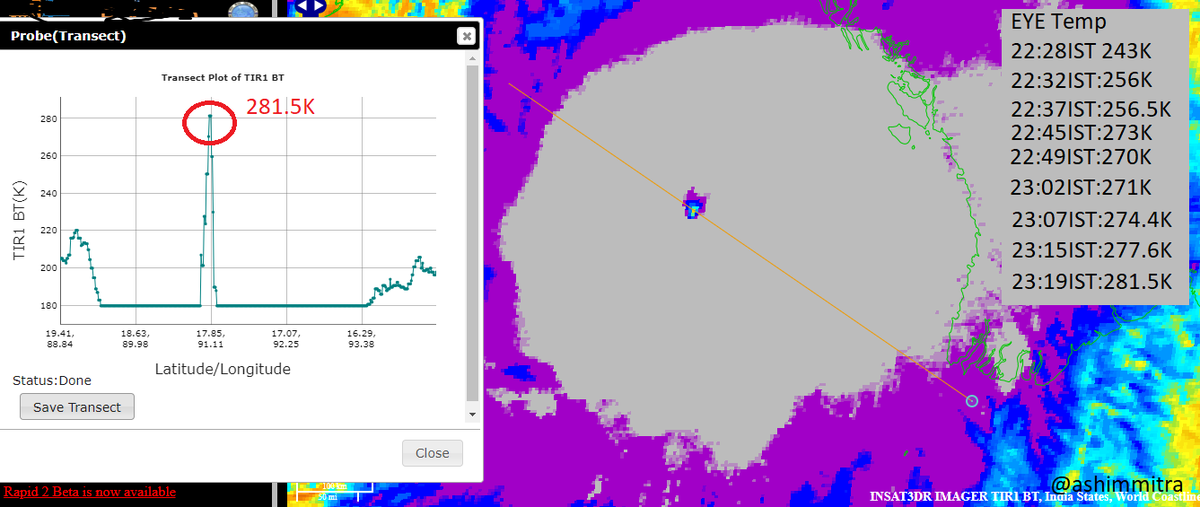
Look at the 'EYE' temperature of #CycloneMocha from #rapidscan of INSAT3DR of past 1 hour!!! its 281.5K. Surely intensifying. Study has also found that increasing BT in the eye of a TC is a good indicator of TC intensification.
More on https://t.co/WfQWJ7k2G1
#MochaCyclone
IR #RAPIDSCAN of #CycloneMocha at 1120IST. Multiple mesovortices can be seen in great detail by rapid scans. Study found that increasing BT in the eye of a TC is a good indicator of TC intensification. BT is determined to be maximal 293.78 K during its peak intensity in TC's eye.
Last Seen Hashtags on Sotwe
Trends for you
Most Popular Users

Elon Musk 
@elonmusk
240.2M followers

Barack Obama
@barackobama
119.3M followers

Donald J. Trump
@realdonaldtrump
111.6M followers

Cristiano Ronaldo
@cristiano
109.3M followers

Narendra Modi
@narendramodi
106.9M followers

Rihanna
@rihanna
97.3M followers

NASA
@nasa
92.1M followers

Justin Bieber
@justinbieber
90.6M followers

KATY PERRY
@katyperry
87M followers

Taylor Swift
@taylorswift13
80.8M followers

Lady Gaga
@ladygaga
72.4M followers

Kim Kardashian
@kimkardashian
69.5M followers

Virat Kohli
@imvkohli
68.8M followers

YouTube
@youtube
68.6M followers

Bill Gates
@billgates
63.5M followers

The Ellen Show
@theellenshow
62.5M followers

CNN
@cnn
61.9M followers

Neymar Jr
@neymarjr
61.4M followers

X
@x
60.9M followers

Selena Gomez
@selenagomez
60.1M followers