Top Tweets for #StokeLevelRising

¡Buenos días, my friends
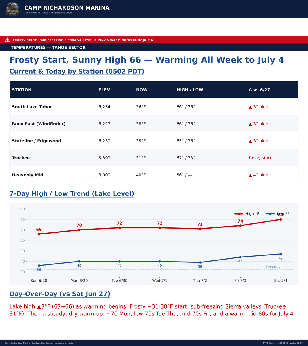
Cup'O'Joe in hand, #StokeLevelRising as we return to a summer-ish pattern: Sunny, with a high near 64º today, and Calm winds, with a wind switch to the north around 5 mph in the afternoon. #MotherNature had her way the past two days with solid sustained SW winds ranging in the 15/25mph zone, with crest gusts upwards of 45/50mph, cool temps, and a blown-out Friday and Saturday. Today, it's back at-it Sunday, with winds currently NE (37º) at 2mph here at CRM, with a switch to the NE, around 11 a.m.-ish. Temps may reach 69/70º-ish; however, with the winds calming, it will feel warmer.
Back at it: SUP, Foil, Surf, and ski. Early birds will get the flat-water. #SurfCity is wide open as I look down the beach, not a soul to be seen. #Slackers
For today, let's get our groove back, head out, bag a peak, seek out the remaining #Sierra wildflowers up in the high-country, if you are headed back to the Bay, I highly reccomend you take SR88 and hit up Lake Margaret, or Woods lake trails for both, and after your hike, hit up the krew at Caples Lake for an adult frostie and lunch. Or head up the West Shore for the view and a lil-lunch at Obexer's Boat Company or the West Shore Market on your way home.
All's good in the hood. Camp Rich Marina opens at 0800, with Reel, Power, and Paddle ops opening shortly after. It's sunrise, and the day is well underway. Enjoy, my friends.
"Choose to be optimistic; it feels better."
― Dalai Lama XIV
Stay'nThirsty
Coop|RS#69


¡Buenos días, my friends
Cup’☕️ ’Joe in hand for #FreakFlagFly'nFriday, Rain falling at the #HippieHaus, #StokeLevelRising for a weekend of inbound #SpringPOW. Mother Nature is officially reclaiming the high country. We have a heavy, unsettled, and beautiful #MaNatural weekend ahead of us. If you have been itching for one last real winter flex before the bullwheel stops spinning, this is your moment.
❄️ The Inbound: Friday and Saturday, The system starts wet today. Expect rain and snow showers, becoming all rain after 1300 PST as temperatures reach a high near 44º. There is a chance of thunder in the mix today, with gusts reaching 29mph. We will not see much accumulation during the daylight hours, likely less than a half inch.
The real transition begins tonight. Snow showers will pick up after 2000 PST with 2-4 inches of a #FreshCoat possible by dawn. On Saturday, a springtime winter vibe settles in, with a high of 41º and gusts up to 41mph. We will add another 1-2 inches to the deck during the day as the atmosphere continues to prime itself for the main event.
🏔️ The Hammer: Saturday Night through Sunday. This is when the storm shows its teeth. Saturday night will bring heavy snow and gusty winds up to 44mph. We are looking at 6-10 inches of accumulation overnight alone.
Sunday keeps the pressure on. It will be a true winter day with a high of only 33º and heavy snow likely throughout the day. Expect another 5-9 inches of accumulation. By the time the system tapers off on Sunday night, we could see a final 2-4 inches before 2300 PST.
Total Sector Outlook: If the models hold, the highest peaks could reach 16-30 inches by Monday morning.
⚠️ Tactical Note: This is a significant late-season system. Travel over the passes will be a challenge, especially on Saturday night and Sunday. The mtn teams will be working hard, but remember that many seasonal crews have already thinned out. Practice patience and keep your winter kit in the rig. Respect the mountain and respect the transition.
“When you think everything is someone else's fault, you will suffer a lot. When you realize that everything springs only from yourself, you will learn both peace and joy.”
― The 14th Dalai Lama
Full Tahoe Sector report 👉: https://t.co/0ZdePGLBF8
Stay'nThirsty for #SpringPOW
Coop
¡Buenos días, my friends
Cup’☕️ ’Joe in hand for #FreakFlagFly'nFriday. #StokeLevelRising. We have some crisp air moving through the basin this morning. It is currently 28º at the #Haus. Passes, Donner-24º, Carson Pass-23º. Up on the peaks, Sibo-18º. Winds have switched up to the East, with ridgetops seeing gusts in the 23/30mph range.
☀️ The Spring Warming Trend: A significant warming trend begins today. Expect temperatures to climb well above average by early next week.
Today: Sunny with a high near 52º.
Saturday: Sunny with a high near 60º.
Sunday: Mostly sunny with a high near 63º.
Enjoy the calm while it lasts. By mid-week, a series of weak waves will approach the Great Basin. This will lead to temperatures peaking on Monday and Tuesday as cloud cover increases. Models are currently diverging for Wednesday, but the trend indicates cooler temperatures and a 20 to 30 percent chance of precipitation.
🏔️ Resort Intel and the Pivot: The season is winding down. Heavenly is scheduled for its final day of the season this Sunday, and we are officially 16 days away from the bull wheels closing for the FY25/26 season. Not to worry, this is the time of year when we simply switch gears. We are trading the sticks and decks for the whips, kayaks, and SUPs. It is time to break out the summer toys from the fun closet and keep the #StokeLevelHigh.
⚠️ Safety Note: Cold Water: If you are dropping in on the river or Big Blue, keep in mind that the water is #ColderThanAWellDiggerArse. Wear a wetty! For those heading out on the lake, please file a float plan on the Lake Tahoe Water Trail site. Let’s ensure everyone gets home for a frosty at the end of the day.
Full Tahoe Sector report 👉: https://t.co/0ZdePGLBF8
“Happiness is not something ready-made. It comes from your own actions.” — Dalai Lama XIV.
Stay'nThirsty for Sunshine, winds, and the summer season on #BigBlue ahead...
Coop
¡Buenos días, my friends!
Cup’O’Joe in hand, #StokeLevelRising as we greet a #ColdSmokeThursday with resolve. We’ve got 4" of fresh on the deck at the #HippieHaus and another 1’ to 2’ on the way.
February has been a masterclass in resilience. #MaNatural has officially flipped the script: KirkwoodMtn is over 230" for the season, and the quality today is #CertifiablyColdSmoke (14-16:1 ratios). If you have the big guns, bring ‘em out.
The High-Stakes Intel:
The Window: Today is the pulse. Friday and Saturday are your high-confidence DRY break to ski the stash and dig out.
The Warning: A major avalanche incident at Frog Lake/Castle Peak yesterday has changed the math. Buried weak layers are reactive—the backcountry is NOT the place to be today.
The Shift: Sunday brings a warmer system with a 7,000’ snow level. We are tracking a rain-on-snow flooding risk for early next week.
Tahoe Sector Report: https://t.co/0ZdePGLBF8
“Tragedy should be utilized as a source of strength. No matter what sort of difficulties, how painful experience is, if we lose our hope, that’s our real disaster.” — Dalai Lama XIV
Stay safe, stay hopeful, and stay thirsty for POW
Coop | RS#69
¡Buenos días, my friends
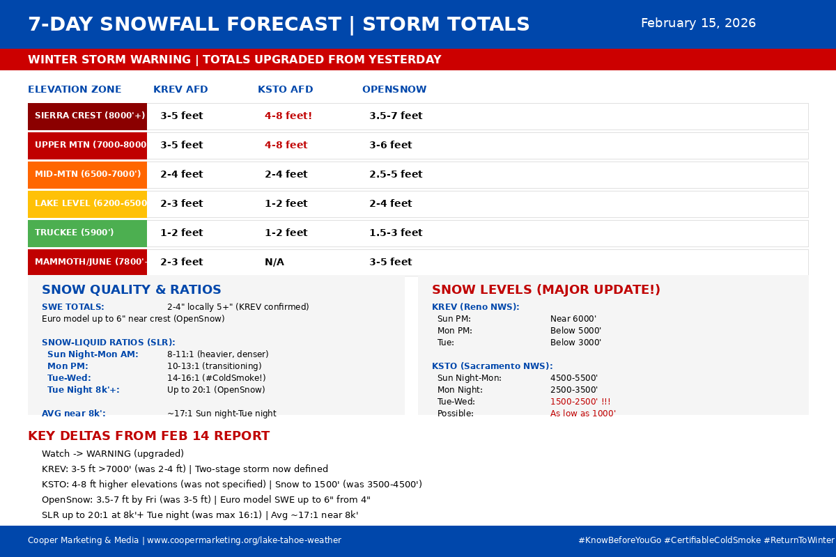
Cup'O'Joe in hand and the #StokeLevelRising as the "Watch" has officially been upgraded to a Winter Storm Warning. This is the monster we’ve been tracking, and the data is only getting bigger.
We are looking at a two-stage winter assault delivering between 3.5 and 7 feet of the lightest, driest #MaNatural we’ve seen all season. Stage 1 hits tonight, but the real hammer drops Tuesday with a cold-air surge that could bring snow levels down to the foothills and ratios to a legendary 20:1.
The Critical Intel:
Travel Alert: Complete all Sierra travel by early this afternoon. Once the snow starts tonight, the window slams shut for 4–5 days.
The Payoff: Thursday and Friday are shaping up to be EPIC.
Mtn Teams: Crews are on 24/7 standby—give ‘em the space and respect they deserve to get the bull wheels turning.
In this update, I break down the HRRR/NAM timing, the KSTO snow-level crash, and the Avalanche Warning details.
Tahoe Sector Watch 👉: https://t.co/0ZdePGLBF8
Stay safe, stay prepared, and stay thirsty for POW
Coop

¡Buenos días my friends,
Cup'O'Joe in hand, #StokeLevelRising, Rain at the HippieHaus, there is snow in them, thare mountains! Chain Controls up regionally, Snow at KirkwoodMtn, Palisades, Sugar Bowl, Mt Rose, and the lot as I type. Snow started as forecast models predicted around 0300, by the looks of the cams and a few sensors, 6" above 7.8k (depending on aspect and elevations). Pure 100% #BaseBuilding Certified #GorillaSnot. Winds, gusty at elevation, Carson Pass clocking in 54/72 (peak 87.5mph).
Today, Rain, Snow as levels drop through the morning sunrise, along with strong, gusty winds expected tonight. By Christmas morning, heavy snow will begin in the Sierra and continue into Friday. Snow levels are around 5,000-6,500 ft by the afternoon and 5,000 ft by the evening. Into Friday, snow levels may be as low as valley floors in western NV, but confidence remains low.
Ok, now, please let's give the Mtn Team the space needed to get our Mtns ready. YES, they want you to ski and ride, but don't be duck'n ropes, drop lines, or be a Jerry, a Kook, or a Karen. On the roads, Tesla guy, slow’yrRoll, and turn off’yr car-assist mode and drive the car, and Tesla trucks, No, No, - they’re not trucks, Period.
Let’s go! Christmas, snow, Üllur, #MotherNature, and Neptune, thank you. You truly tested our resilience, patience, and salt as Tahoeian-sentients; some passed, others failed. We are now stronger, wiser, and ready to begin our PowHunt'nSeason.
Current Sector Data & Road Status:
Temps: Cooling trend active (36ºF at Lake Level).
Winds: Hurricane force gusts (72mph+) at Carson Pass.
Roads: MESSY, SLICK, NASTY. R2 Chains on SR88, Hwy 50, and I-80. If you are travelling today, pack patience. It is white-knuckle driving over the passes.
Forecast Update: The Christmas Eve Transition
We are watching the collision of moisture and cold air in real-time.
Advisories: Winter Storm Warning (4-8 FEET forecast above 5,500’) and Flood Watch are active.
"NWS Reno indicates snow levels will "tumble" this afternoon to between 6,000-7,000’ in the Basin due to the “Wet-Bulb Effect.”
The Wind: Ridge gusts are forecast to hit 80-100 mph today. Do not expect upper-mountain lifts to spin.
Full Tahoe Sector Report: https://t.co/0ZdePGLBF8
Stay'nThirsty for POW,
Coop | RS#69
¡Buenos días my friends,
Cup'O'Joe in hand, #StokeLevelRising, on a #SoulfulSunday. As I type here at the #HippieHaus, the roads are open, but the rain and winds are here. Webcams at Palisades, Kirkwood, and Sugar Bowl are all showing rain at base level.
A Note on the Forecast: This forecast has been a humbling journey, a complex puzzle that refuses to be rushed. I will not stand here and fabricate a timeline for when the turn to snow will happen; that transition remains a mystery for now. I haven't lost faith; I am simply releasing the need to control the clock. Why #OverStoke when we can simply be?
I am choosing to stay calm and watch the windows. I'm going to wash the truck, throw on the Hawaiian shirt, break out the flippies, and breathe in the sunrise.
Live On Air: Ski California Winter Weather Show: In about thirty minutes, I'm heading up to Truckee to take the helm for the Ski California Winter Weather Show from 0700–1000. We'll be spinning tracks to feed the soul, discussing the atmospheric dance, and checking in live with the crews at Palisades, Sugar Bowl, and Boreal for the ground truth.
Tune in: https://t.co/4UBH5hBO7y
The Data (The Reality):
* The Precip: The Atmospheric River is overhead. We are looking at a Flood Watch for the Basin with a 70-80% chance of 3+ inches of liquid through Monday.
* The Wind: The jet stream is screaming. Expect ridgetop gusts of 100+ mph and valley gusts of 50-65 mph.
* The Mid-Week Signal: While today is wet, the signal for the Christmas storm has improved. NWS Reno reports a 60-70% probability for over 1 FOOT of snow at Lake Level by Friday afternoon.
The Strategy: Today is about patience, gratitude for the moisture (even if it's liquid), and prepping for the shift. The stats don't lie—the mid-week storm has the potential to deliver feet, not inches. But for today? Put on the Hawaiian shirt, grab that Cup'O'Joe, and tune into 101.5.
Tahoe Sector Report: https://t.co/0ZdePGLBF8
Peace, patience, and POW dreams.
Coop | RS#69

A wet storm moves through Thursday into Friday. It draws in warm subtropical moisture which will likely bring very high snow levels to start. Then falling some into Friday. Several inches of wet snow is possible for the upper mountains by the end.
https://t.co/QUqXPFNdOp
On with the Weather Underground team tonight with Mike Bettes and Dr Nab - #StokeLevelRising as it is still snowing here at the #HippeHaus!
Stay'nThirsty for POW
Coop
#StokeLevelRising as we begin to track an early-season system arrival. #MotherNature's looking to deliver the first real measurable #BaseBuilder - #GorillaSnot

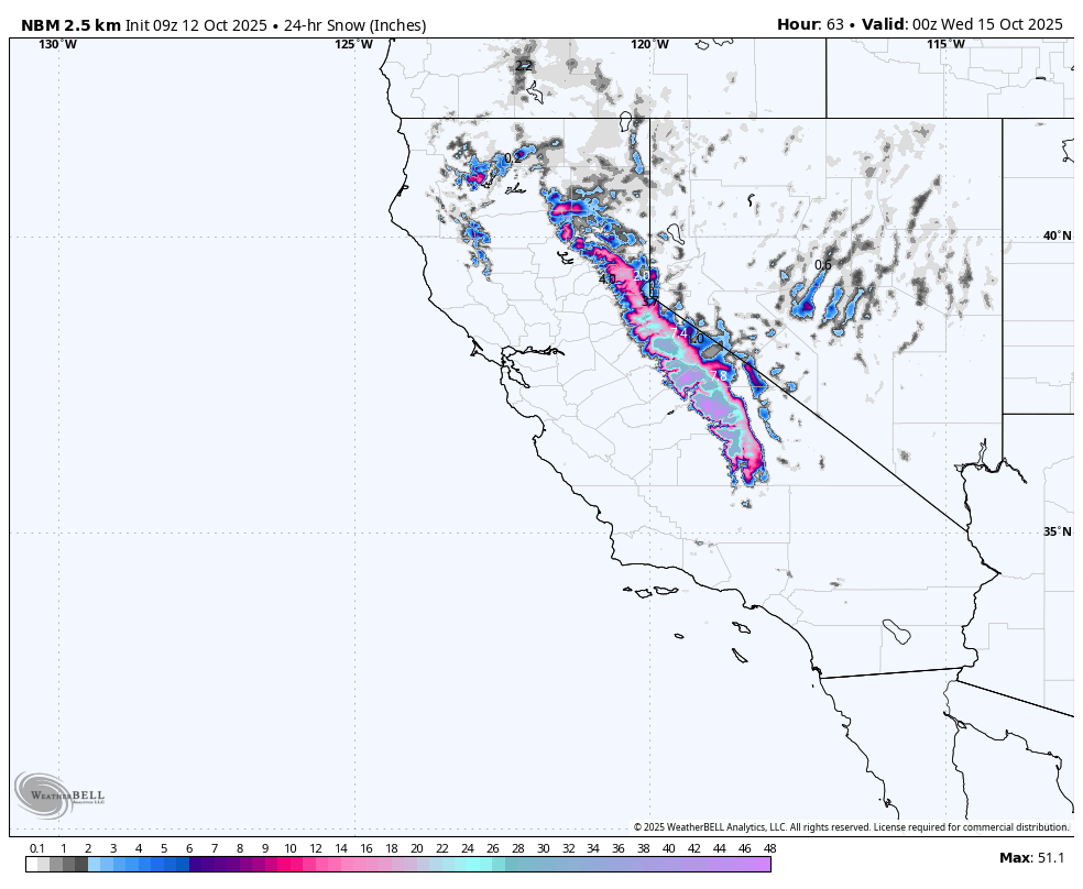
#StokeLevelRising - Forecast guidance as of 0550 has the crest stacking with the first measurable snow/snain #GorillaSnot totals of the season. Quick-hit, but a nice little October surprise for sure...
Stay'nThirsty, ready for POW'Slay'n Season
Coop
Buenos dìas, my friends! ☕ Cup'O'Joe in hand, #StokeLevelRising as we scope the latest weather from Lake Tahoe to SoCal: Dry & calm midweek (the storm is certainly not a #BaseBuilder, that's for sure, but we'll take every angry inch!), then a weekend system brings light snow & rain. #MaNatural refresh on tap! ❄️
Today's Conditions: #Firm, like real firm, however MTN Teams out throughout the night dropping the tillers and creating some amazballz cord for your carving pleasure - Off-piste / BC - #BoilerPlate - Choose your lines wisely.
Details: [https://t.co/dbhoJngkx3] #YouKnowBeforeYouGo
Cup'O'Joe in hand, #StokeLevelRising, and solid at 10.3 this fine #SoulfulSaturday; Winds will pick up mid to late morning on the lake, not as heavy as yesterday afternoon, but a solid 13-15...
For the Full forecast - Click the link and take the ride.
https://t.co/dGAmpOW23D
Warm up today, then it's GameOn!
Storms roll in tonight, bringing snow back to the Sierra Crest.
❄️Heavier snowfall likely Fri-Sat = #MotherNaturesNatural #CaliPass #StokeLevelRising #MarchMadness #AkovaLife
Stay'nThirsty for POW
Coop
Buenos dias, my friends
Cup'O'Joe in hand with the #StokeLevelRising on a mid-March Sunday #PowderDay. It's not a #ColdSmokeSunday; nevertheless, it's a #PowderDay!
Overall Outlook
Lingering Snow Showers: Snow showers continue through today, especially in the Sierra but are gradually tapering off. Drier conditions prevail from this afternoon onward.
Cooling Temperatures: The weekend's cooler temperatures will persist through today. Expect a slight warming trend starting tomorrow.
Mid-Week System: Another weather system arrives around Wednesday, bringing more rain, mountain snow, and potentially thunderstorms.
China Peak (NWS Hanford)
Snowfall: The Winter Storm Warning continues until 5p today. Up to one additional foot of snow is possible in the Sierra Nevada. A Winter Weather Advisory is also in effect for the Kern County mountains above 5,000 ft.
Winds: Strong west wind gusts near 55 mph will persist in the Kern County desert until 11p this evening (Wind Advisory remains in place).
Thunderstorms: A few strong thunderstorms are possible across Central California this afternoon. Be aware of the potential for lightning, small hail, gusty winds (up to 45 mph), and funnel clouds.
Changes from Yesterday: Snowfall totals may be slightly lower than initially expected, but significant accumulation has occurred.
Bear Valley & Dodge Ridge (NWS Sacramento)
Snowfall: Lingering snow showers will continue through today, then taper off this afternoon with only 2-4” inches of additional snow likely.
Winds: Winds will gradually decrease today.
Thunderstorms: This afternoon, there is a small chance (10-15%) of thunderstorms, mainly in areas south of the resorts. Conditions are less favorable than on previous days.
Changes from Yesterday: Snowfall totals are expected to be lower than initially projected, and the chance of thunderstorms has decreased.
Extended Forecast
NWS Hanford: Dry conditions are expected Sunday afternoon through Tuesday. There is potential for another significant storm system next weekend.
NWS Sacramento: Mostly dry conditions Monday and Tuesday. The next weather system arrives around Wednesday, bringing a chance of widespread rain, snow showers, breezy winds, and isolated thunderstorms. This is not currently projected as a high-impact event, but precipitation amounts and snowfall totals will become clearer over the next few days.
Stay'nThirsty for POW
Coop
#CaliPass #PowAlert #FreshTracks #SkiCalifornia #AkovaLife
Buenos dìas, my friends
Cup'O'Joe in hand with the #StokeLevelRising as Ole KingNeptunem Ullr, and #MotherNature prep for a #HolidayReFresh and blessing for Skiers and Riders here in the Sierra. It's not a #BigDuckDump, as mentioned yesterday, but a good shot at a few inches of #GorillaSnot for the Mtn Teams to work with to improve your sliding surfaces. Snow levels, HIGH! 7,500' and above through Monday night; maybe with a little help from winds and geographic lift, we'll see snow levels at the 6,800' mark?
Nonetheless, it's weather, and we need precipitation in the forms of rain, stain, and snow... Prep for a challenging drive to the Sierra, over I80, SR88, and Hwy50; expect chain controls on and off depending on temps. For an easier commute, check the Hwy4 corridor and Bear Valley Resort. They are open today and again for the season, with 7-day operations starting on Friday.
NWS Summary - West Slope
Early this morning, the latest GOES-West imagery shows increasing cloud cover from the southwest beginning to overtake the region as troughing off the coast inches closer. Early morning low temperatures will reflect this trend, with Valley lows in the upper 30s to low 40s. As the day progresses, cloud cover will continue to filter in and limit high temperatures to the upper 50s to low 60s in the valley and low to mid-50s in the mountains. Precipitation chances will gradually begin to increase late this evening into the week ahead. Best chances for periods of moderate to heavy rain are anticipated on Monday and Tuesday, with precipitation chances beginning to taper off throughout the day on Wednesday.
The latest probabilities of exceeding 1" of QPF from late Sunday through Wednesday are in the 80 to 100% range, with probabilities of exceeding 3" of QPF in the 15 to 30% range in the Valley and 70 to 90% range over the mountains. Furthermore, high-elevation snowfall is also expected as this system travels through. Snow levels in the 7500 to 8,000-foot range are expected Monday and Tuesday before lowering to the 6,500 to 7,500-foot range on Wednesday. As a result, probabilities of exceeding 4" of snowfall are in the 60 to 90% range, with probabilities of exceeding 8" of snowfall in the 50 to 80% range. The best chances for accumulating snowfall are expected near Lassen Peak and south of the Highway 50 corridor at elevations of 7,500 feet or greater for much of the event.
#SolidSundayLama
"Human beings do not live in a vacuum; we live in a society. Thus, it is important to look at the values promoted and celebrated in a given society and measure what effect this conditioning has on our sense of independence or of interdependence.”
― Dalai Lama
Stay'nThirsty for POW
Coop
Buenos dìas, my friends
Cup'O'Joe pouring through the forecast models with the #StokeLevelRising as #MotherNature, and Ole KingNeptune seem to have come into alignment with a set of systems now approaching the West Coast, more towards the #DirtySouth, Bear Valley Resort, Unofficial Kirkwood Community, and down towards Mammoth Mountain... Not a ton, load, huge, massive, or a #BIgDuckDump, let's just say, a #Solid 6" to 8" along the Crest, with areas in the 8" to 10" range depending on elevation and zone. This is a bit warm; snow levels look above the 7,500' mark, so low-level base areas may be in the rain/snain zones...
Good news: The Holidays will have a #FreshCoat here in the Sierra and down the Western Front to China Peak Mountain Resort. Mtn Teams will be out in force, capturing every flake to ensure your Holiday here in the Sierra will be amazing as always.
Hey, if you're in the Bay, Sac, Central Valley, or Coastal, remember to load up the #TahoeRoadKit when you hit the road! You know, extra food, water, blankets, bags, flashlights, flares, fully charged celly, Full tank of gas, or Charge when driving over the passes, I80, Hwy50, SR88, Hwy4, or SR108... Prepare... Caltrans District 3, CHP - South Lake Tahoe, will do everything possible to keep the roads open; however, #MotherNature is in Charge, and they may have to close them down for your safety... Just Say'n
NWS Regional Summary:
As the trough mentioned above meanders eastward late Sunday into the early week ahead, precipitation chances will also increase. Generally, light precipitation is anticipated late Sunday into early Monday, with periods of moderate to heavy rainfall then expected Monday and Tuesday. As this is a relatively warm system, rain will be the region's primary precipitation type. That being said, snow levels will remain around 7,000 to 8,000 feet through the early week, likely confining much of the accumulating snowfall to high elevation/peak levels. The best chances for the heaviest snowfall will be at these high-elevation areas near Lassen Peak and south of the Highway 50 corridor.
At this time, probabilities of exceeding 1" of QPF through the early week period are in the 60 to 90% range, with probabilities remaining the same over the mountains but lowering to the 30 to 60% range in the Valley for probabilities of exceeding 2" of QPF. As for snowfall, probabilities of exceeding 4" are in the 60 to 90% range for elevations generally more significant than 8,000 feet, with probabilities of exceeding 8" in the 40 to 80% range for the same areas. Furthermore, increasing south-to-southeast winds are also anticipated Monday into Tuesday, with occasional gusts of 35 to 35 mph possible, strongest across the Sierra.
#SoildSaturdayDali
“Choose to be optimistic. It feels better.”
― Dalai Lama XIV
Stay'nThirsty for POW
Coop
Evening, my friends
Glass'O'red in hand with the #StokeLevelRising tonight... A change in the forecast models is looking quite real... More in the AM...
In the heart of the Sierra, where the wild winds blow, Amidst the whispering pines and the pristine snow, There lies a realm where the adventurous souls meet, Crafted by hands that never accepted defeat.
Majestic mountains, their peaks touching the sky, A playground for the brave, where eagles dare fly. In these natural parks, where the spirits soar free, We find our haven, our wild sanctuary.
Oh, Original Mtn Ops OGs, with hearts so bold. Your stories of passion and courage are forever told. With shovels and dreams, you carved paths in the white, Turning daydreams into trails under the moonlight.
From the Western Slopes to the Sierra's embrace, You sculpted each curve with an artist's grace. Your heritage is a tapestry woven with thrill. In each jump and turn, your spirit lives still.
Your legacy is a testament to the daring spirit. In the tracks left behind, we feel your merit. For every rider who seeks the mountain's call, Finds in your creation a challenge to enthrall.
In the hush of the dawn, when the first light gleams, We ride your trails, living out our wildest dreams. For in these mountains, your history is scribed,
In every run, your legacy is inscribed.
So here's to you, architects of our joy and fears, For igniting the fire that burns through the years. Your passion is a beacon that guides us to soar in the Sierra's heart forevermore.
Through snowflakes and sun, your spirit endures; in every carved turn, your memory assures. For in these mountains, your dreams took flight, And in our hearts, you shine ever bright.
Stay'nThirsty For POW
Coop

Buenos días, my friends,
Cup'O'Joe in hand, with the #StokeLevelRising here at the #HippieHaus, 9.6 with the wind S@2mph temps around the basin vary from 12º in TRK to 22º at 9,100...
Forecasts are beginning to tell the tale of a minor disturbance in the force over the next 48-96 hours. Not a whomper by any stretch of the imagination, but we are at the least looking at a few inches here and across the Sierra Crest, which will assist the Mtn Ops teams in filling in the base areas and potentially open a few more acres of terrain. Some resorts that rely on #MotherNaturesNatural will be #Stoked to see 4" to 6", which will most likely be high; we are looking more at 1" to 4."
KirkwoodMtn
• Current temp @9,186 = 22º
• Winds - S -9mph
• Wet Bulb - 24
• Dew Point -17.1º
• Relative Humidity - 66
• Dewpoint - 17
Total QPF/Snowfall continues to fluctuate, as should be expected, given we are on the southern periphery of a fast storm track where slight variations inherently bring some uncertainty into the forecast process. For example, this morning's official forecast is a bit wetter than Tuesday afternoon's forecast but drier than the previous night's forecast. For the first few systems Thursday through early Saturday, forecast snowfall accumulations range from 3-6" along the crest and 1-4" in Sierra valleys and northern Lassen/Washoe counties to generally a dusting to 1/2" elsewhere. However, ensemble guidance, now including the latest SREF, continues to show a handful of wetter scenarios where the Tahoe Basin could receive double the projected amounts. At the same time, some western NV locations could reach or exceed 1" of snowfall (roughly a 20% chance). The most significant impacts will be at night and during the late afternoon/early morning periods when temperatures will be cold enough to allow for some slick road conditions. This would include the Friday morning commute. Snow levels are expected to rise by Sunday, reducing the impacts to mainly Sierra passes.
NWS Weather Forecast for Bear Valley | Dodge Ridge
CW4253 Bear Valley (C4253)
Lat: 38.468°N | Lon: 120.047°W | Elev: 7201.0ft.
• Current temp = 36º
• Humidity - 7%
• Winds - 0mph
• Barometer - 29.87in (1011.51mb)
• Dewpoint - -22ºF (-30ºC)
Radar shows showers moving over the Delta region and Coastal Range and into the Valley. This marks the start of precipitation chances over the area for the next few days. Showers will mostly be relegated to the overnight and early morning hours in the Coastal Range, Delta region, and western side of the Valley, receding in the morning until late Thursday when showers will begin again in the mountains. Low temperatures this morning and on Thursday morning will be slightly warmer than they have been the last few days due to cloud cover from the current low-pressure system. However, Valley lows are still on track to reach around the mid 30ºs to low 40ºs the next couple of days, so chilly mornings aren't entirely out of the picture. High temperatures today and Thursday will remain mild, with Valley temperatures in the low 60ºs and temperatures in the foothills and mountains reaching the mid-50ºs and mid-40ºs to low 50ºs, respectively.
As we move into late Thursday and early Friday, another fast-moving low-pressure system will move over the area, bringing cooler temperatures and higher chances of precipitation. Valley rain will be light and mostly relegated to the eastern portion near the foothills; otherwise, precipitation can primarily be expected in the foothills and mountains. Currently, the NBM is showing a 10 to 20% chance of a quarter inch or more of precipitation in the Valley and a 35 to 65% chance in the foothills and mountains. There is also a 15 to 55% chance of snow accumulations of 6" inches or more in the mountains. Snow levels will also fluctuate over this period, starting around 4,500 to 5,000 ft on Thursday, lowering to 3,000-4,000 ft by early Friday, and eventually rising again to 4,000 to 4,500 ft later that day.
NWS Weather Forecast for China Peak
(KSPC1)Lat: 37.29833°N | Lon: 119.10333°W | Elev: 9129.0ft.
• Current temp = 22º
• Humidity - N/A
• Winds - N/A
• Barometer - N/A
• Dew Point - N/A
A trough of low pressure will dive southeastward from the Pacific Northwest Thursday morning. This trough of low pressure will be responsible for a slight chance of rain in the San Joaquin Valley and the chance of snow in the Sierra Nevada on Thursday afternoon and Thursday night. The snow will start at around 6,000 feet Thursday afternoon before falling to about 5,000 feet Thursday night. Less than one-tenth of an inch of rain is possible in the Sierra Nevada foothills Thursday afternoon and night. An inch or less of snow is conceivable in the Sierra Nevada above 5,000 feet Thursday afternoon and Thursday night.
NWS Weather Forecast for Mt High
(E0585)Lat: 34.3495°N | Lon: 117.62217°W | Elev: 5997.0ft
• Current temp = 30º
• Humidity - 70%
• Winds - 0mph
• Barometer - 29.4in (1013.89Mb)
• Dew Point - 21º (-6ºc)
A cool and unsettled weather pattern will affect southern California for the latter half of this week as a series of weak storm systems move across the region. Isolated to scattered light showers and areas of gusty northerly winds are expected to accompany these systems from Wednesday through Saturday. A warming and drying trend is expected Sunday into early next week, with increasing offshore flow.
More significant amounts are expected in bands of showers. For San Diego County, from the coast to the mountains, chances for one-tenth or more of rainfall are:
• Generally, 75% to 80% percent.
• Around 20% percent for one-half inch or more.
• About 5% percent for one inch or more.
The snow level will fluctuate between 5,500 and 6,500 feet, with a few inches of snowfall possibly above 6,000 feet.
# WednesdayDaliWisdom:
"In many areas, too, people are having to deal with environmental problems and, with these, threats to their livelihood and worse. At the same time, many others are struggling to get by in the face of inequality, corruption, and injustice."
― Dalai Lama XIV
Stay'nThirsty for POW,
Coop

Buenos días, my friends,
Cup'O'Joe in hand, with the #StokeLevelRising here at the #HippieHaus, 9.6 with the wind S@4mph temps around the basin vary from 10º in TRK, to 23º at 9,100' or in more laymen terms, #ColderThanAWellDiggersAss...
I am starting to see the models gel, with the official forecast showing generally less than 1" in the lower valleys, 1-3" for Sierra valleys, and up to 6" near the crest. However, GEFS/ECS meteograms and the upper range of the blended guidance continue to leave a wetter scenario with a 20-30% chance of seeing double these forecast amounts. Impact potential is there for travelers, especially outside of daylight hours. So, if you have travel plans late next week, stay tuned as we hone in on the details.
NWS Forecast Tahoe: Today, through Thursday: A low-pressure system off the CA coast this morning will move inland and open up Wednesday, with most of the model guidance taking the brunt of the forcing southward now, skipping the Sierra and western NV. There were a few holdouts, so we maintained low pops and minimal QPF along the Sierra Wednesday. Otherwise, light winds, below-average temperatures, and periods of broken-overcast skies will be the general rule for the next few days.
NWS Forecast for Bear Valley | Dodge Ridge: Another quick-hitting system will likely brush by Thursday night into early Friday, bringing some showers, mainly over the mountains. Behind that, clusters indicate uncertainty for late in the week, with many members favoring at least weak ridging over NorCal into the weekend. Warm advection may provide some lift to moisture coming into the region, and some QPF may occur over the mountains with only low chances for light amounts (mainly less than 0.10") in the Valley.
NWS Forecast for China Peak: Near-freezing overnight low temperatures through Wednesday morning. A Freeze Warning is in effect until Wednesday morning. Rain and snow chances increase on Wednesday. The best chance for rain will be Thursday night into Friday, with a 20 to 30 percent chance of a tenth of an inch of rain in the Valley. Snow levels are expected to drop to about 4,000 feet Thursday night into Friday morning. Temperatures warm up on Sunday into early next week.
NWS Weather Forecast for Mt. High: Today will be the last dry day with temperatures near to slightly above average; a calm and unsettled weather pattern will develop for the latter half of the week as a series of Pacific storm systems move over the region. Occasional light showers with snow above 5,500 feet are expected Wednesday through Saturday. A warming and drying trend is expected Sunday into early next week.
#TuesdayDaliWisdom:
“The fundamental nature of the mind is pure and stable. The innate, subtle mind of clear light, which is the basis of the cultivation of positive states of mind, is stable in that it continues eternally without interruption.”
― Dalai Lama XIV
Stay'nThirsty for POW,
Coop

Last Seen Hashtags on Sotwe
Trends for you
Most Popular Users

Elon Musk 
@elonmusk
240.6M followers

Barack Obama
@barackobama
119.2M followers

Donald J. Trump
@realdonaldtrump
111.7M followers

Cristiano Ronaldo
@cristiano
110.5M followers

Narendra Modi
@narendramodi
107M followers

Rihanna
@rihanna
97.6M followers

NASA
@nasa
92.2M followers

Justin Bieber
@justinbieber
90.9M followers

KATY PERRY
@katyperry
87.6M followers

Taylor Swift
@taylorswift13
81.5M followers

Lady Gaga
@ladygaga
73M followers

Virat Kohli
@imvkohli
69.8M followers

Kim Kardashian
@kimkardashian
69.8M followers

YouTube
@youtube
68.7M followers

Bill Gates
@billgates
63.9M followers

Neymar Jr
@neymarjr
62.5M followers

The Ellen Show
@theellenshow
62.4M followers

CNN
@cnn
61.9M followers

X
@x
60.8M followers

Selena Gomez
@selenagomez
60.7M followers