

Top Tweets for #Wadeye

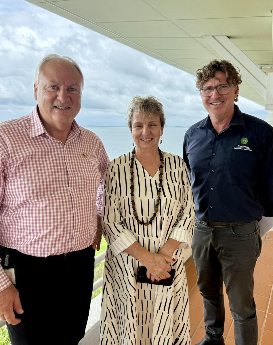
Terrific meeting with CEO John Gawen and Deputy Chief Executive Officer Tracey Leo from the #Thamarrurr Development Corporation (#TDC).
I look forward to visiting #Wadeye soon to learn more the issues and to see firsthand how we can work together to get better outcomes for the community.

I think that's the local dope dealer trying to make a reverse exit in the troop carrier. He didn't have enough to go around ?
#Wadeye

4 weeks of unrest on the community of Wadeye

* #SevereTropicalCycloneFina, Category 3, is causing gale-force winds and heavy rainfall over the #Darwin area, winds may possibly increase further over the next few hours.
Area affected
*** CYCLONE WARNING
The #TiwiIslands and #CapeHotham to #Wadeye. This includes #Darwin, #Pirlangimpi, #Milikapiti, #Wurrumiyanga and #Wadeye.
CYCLONE WATCH zone
Troughton Island to WA/NT Border.
Cancelled zone
Area west of Point Stuart to Cape Hotham, and inland areas east of Middle Point.
At 9:30 pm Australian Central Standard Time
At 9:30 pm ACST
Intensity
category 3, sustained winds near the centre of 130 kilometres per hour with wind gusts to 185 kilometres per hour
Location
within 20 kilometres of 12.1 degrees South, 130.6 degrees East, 50 kilometres northwest of Darwin and 40 kilometres south southwest of Wurrumiyanga
Movement
west southwest at 8 kilometres per hour
Darwin radar and satellite imagery shows #Fina to the northwest of Darwin as a small but intense system. Based on Fina's forecast west southwest track, the very destructive core is likely to pass just north of Darwin tonight. After passing Darwin, Fina is forecast to maintain severe tropical cyclone intensity on Sunday and into Monday as it moves through the southern Timor Sea, and then start weakening during Monday or Tuesday near the #KimberleyCoast.
Hazards
VERY DESTRUCTIVE WIND GUSTS to 185 km/h are occurring along the south coast of Melville Island and Bathurst Island with a chance of reaching Wurrumiyanga over the next few hours. Very destructive wind gusts are possible about exposed coastal sites north of Darwin (including Gunn Point) but are less likely at Darwin.
DESTRUCTIVE WIND GUSTS to 155 km/h are likely to continue to extend west over southern parts of the Tiwi islands, including Wurrumiyanga. Destructive gusts may extend to the Darwin region in the next few hours and possibly further to #DundeeBeach tonight, particularly if Fina moves in a more southerly direction.
GALES with DAMAGING WIND GUSTS to 120 km/h are occurring over the Tiwi Islands and from Darwin northeast to #CapeHotham. Gales may extend southwest to Dundee Beach tonight, Daly River Mouth early Sunday, and if Fina takes a more southerly track, gales could extend south to Wadeye during Sunday.
Later Sunday or on Monday, GALES may extend to coastal parts of the north Kimberley in WA, from Kalumburu to the WA/NT Border, but not including Wyndham or Kununurra.
HEAVY to LOCALLY INTENSE RAINFALL, which may lead to FLASH FLOODING, is currently occurring around Darwin, and will be possible over the Tiwi Islands and elsewhere about the mainland coast between Cape Hotham and Dundee Beach, during the remainder of this evening. The risk of HEAVY RAINFALL about coastal and adjacent inland areas will extend southwest to the Daly River Mouth overnight and on Sunday. Also refer to adjacent Severe Weather Warning.
Coastal residents on the Tiwi Islands, and between Cape Hotham and Warruwi are specifically warned that tides are likely to rise above the normal high tide mark with LARGE WAVES and MINOR FLOODING of low-lying coastal areas.
Respectfully,
Roshin

* #SevereTropicalCycloneFina, Category 3, is causing gale-force winds and heavy rainfall over the #Darwin area, winds may possibly increase further over the next few hours.
Area affected
*** CYCLONE WARNING
The #TiwiIslands and #CapeHotham to #Wadeye. This includes #Darwin, #Pirlangimpi, #Milikapiti, #Wurrumiyanga and #Wadeye.
CYCLONE WATCH zone
Troughton Island to WA/NT Border.
Cancelled zone
Area west of Point Stuart to Cape Hotham, and inland areas east of Middle Point.
At 9:30 pm Australian Central Standard Time
At 9:30 pm ACST
Intensity
category 3, sustained winds near the centre of 130 kilometres per hour with wind gusts to 185 kilometres per hour
Location
within 20 kilometres of 12.1 degrees South, 130.6 degrees East, 50 kilometres northwest of Darwin and 40 kilometres south southwest of Wurrumiyanga
Movement
west southwest at 8 kilometres per hour
Darwin radar and satellite imagery shows #Fina to the northwest of Darwin as a small but intense system. Based on Fina's forecast west southwest track, the very destructive core is likely to pass just north of Darwin tonight. After passing Darwin, Fina is forecast to maintain severe tropical cyclone intensity on Sunday and into Monday as it moves through the southern Timor Sea, and then start weakening during Monday or Tuesday near the #KimberleyCoast.
Hazards
VERY DESTRUCTIVE WIND GUSTS to 185 km/h are occurring along the south coast of Melville Island and Bathurst Island with a chance of reaching Wurrumiyanga over the next few hours. Very destructive wind gusts are possible about exposed coastal sites north of Darwin (including Gunn Point) but are less likely at Darwin.
DESTRUCTIVE WIND GUSTS to 155 km/h are likely to continue to extend west over southern parts of the Tiwi islands, including Wurrumiyanga. Destructive gusts may extend to the Darwin region in the next few hours and possibly further to #DundeeBeach tonight, particularly if Fina moves in a more southerly direction.
GALES with DAMAGING WIND GUSTS to 120 km/h are occurring over the Tiwi Islands and from Darwin northeast to #CapeHotham. Gales may extend southwest to Dundee Beach tonight, Daly River Mouth early Sunday, and if Fina takes a more southerly track, gales could extend south to Wadeye during Sunday.
Later Sunday or on Monday, GALES may extend to coastal parts of the north Kimberley in WA, from Kalumburu to the WA/NT Border, but not including Wyndham or Kununurra.
HEAVY to LOCALLY INTENSE RAINFALL, which may lead to FLASH FLOODING, is currently occurring around Darwin, and will be possible over the Tiwi Islands and elsewhere about the mainland coast between Cape Hotham and Dundee Beach, during the remainder of this evening. The risk of HEAVY RAINFALL about coastal and adjacent inland areas will extend southwest to the Daly River Mouth overnight and on Sunday. Also refer to adjacent Severe Weather Warning.
Coastal residents on the Tiwi Islands, and between Cape Hotham and Warruwi are specifically warned that tides are likely to rise above the normal high tide mark with LARGE WAVES and MINOR FLOODING of low-lying coastal areas.
Respectfully,
Roshin


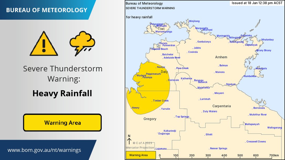
⚠️⛈️ 4:05am: Severe Thunderstorm Warning for heavy #rainfall in parts of the Daly and Gregory districts.
Severe storms may produce flash #flooding in the warning area. Locations which may be affected include #Wadeye and #TimberCreek.
Details: https://t.co/W97hNdzpbr


@katiebecker16 You're talking about Port Keats mission, #Wadeye. A big community with a long history of forced relocations so tensions. Lots of proactive programs happening. @abc730 did a report last week. Ask yourself why you're hearing about violence a year ago now?🤔 https://t.co/fk7udwkRiU

Just another day of Fighting in a remote indigenous community #Wadeye SW of Darwin has been so intense that as many as 500 people are now homeless.
A man there was reportedly killed when a spear struck him in the head.
Vol. up
#VoteNo
https://t.co/3JngZGAWKu via @newscomauHQ
#Wadeye was created in the middle of nowhere to give local Aboriginals a 'better' life. Now there's 22 clans at war in the township - & there's no end in sight to the brutal violence
Time to shutdown these communities
(enclaves) split clans/gangs into society to learn civility
https://t.co/174DRFexH2
You would swear this was Africa if kids faces weren't so familiar.
#Wadeye is large remote Aboriginal community 420 KM by road south-west of Darwin
Aust. Gov currently spends $35 billion P/A on Aboriginal affairs.
We need a Royal Commission into how that money is distributed?


LOCALS in the remote community of Wadeye will dance on the ceremonial sands when rapper J-MILLA takes his concert to the world via live-stream on @tiktokaustralia, tomorrow (June 1).
READ the full story in our current edition: https://t.co/nzpx1FMD7c
#KooriMail #JMILLA #Wadeye

OUR latest edition is on sale today!
SUBSCRIBE to receive our fortnightly paper straight to your door, phone or PC: https://t.co/T4uWSLFKSb
#KooriMail #Indigenous #FirstNations #Blak #Wadeye #NorthernTerritory #JMILLA #TikTok #CeremonialDance #DanceOff #NewEdition


Thankfully I didn’t get to watch the bombers lose but at least I saw a cool sunset on the flood plains #wadeye

⚠️Severe Thunderstorm Warning⚠️ for heavy rainfall that may lead to flash flooding. Locations include #Wadeye, #TimberCreek and #Nauiyu. Stay safe and remember, if it's flooded, forget it! Check latest warnings at https://t.co/OqPL6XS7cI

TC #Ellie has formed & will make landfall just N of #Wadeye, #NorthernTerritory late Thursday night, locally. Heavy rain will spread S across W #NT & NE #WesternAustralia through Sunday. Monsoon trough will remain active into early Jan with additional low development possible.
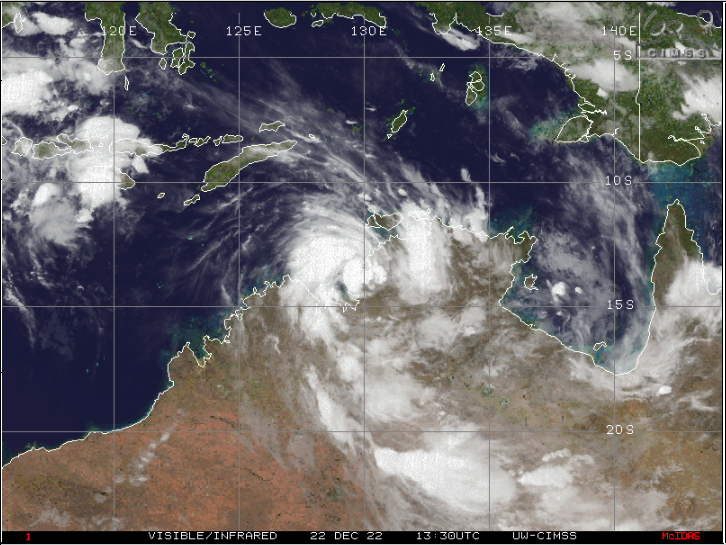

The Bureau of Meteorology has just named #Ellie from 06U as it rapidly consolidates in the Timor Sea, with radar showing the development of a formative eyewall. The intensification rate is expected to remain rapid until landfall near #Wadeye, #Australia in early morning.
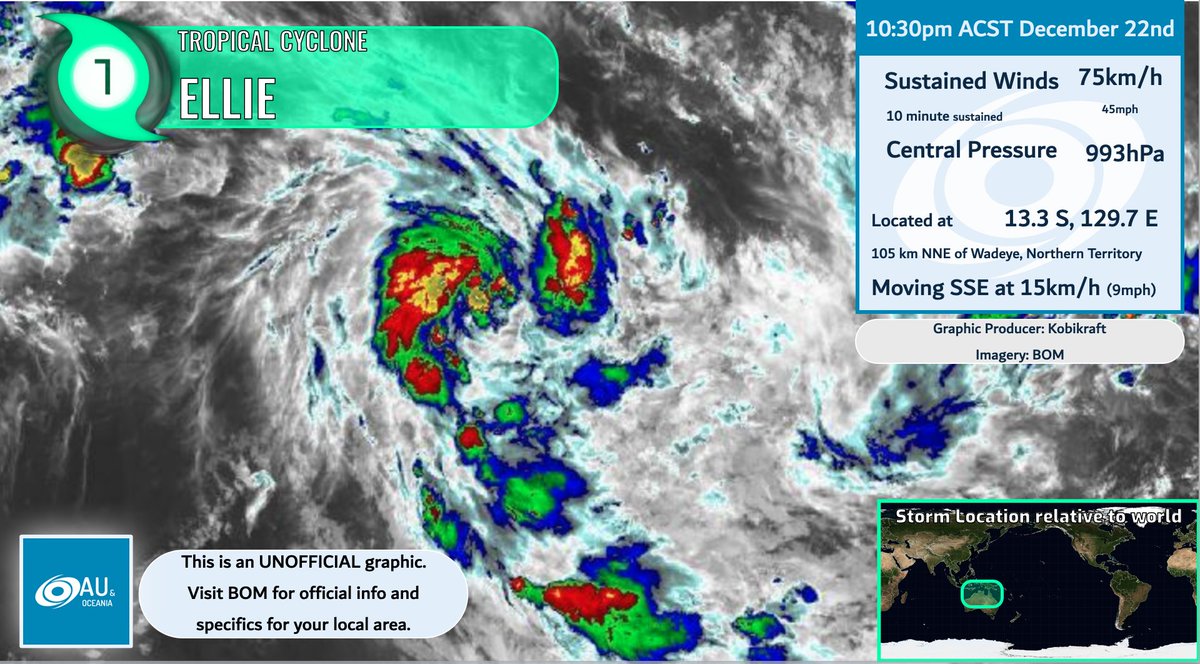

The Bureau of Meteorology has just named #Ellie from #cyclone 06S as it rapidly consolidates in the Timor Sea, with radar showed a formative eyewall formed. The intensification rate is expected to remain rapid until landfall near #Wadeye, #Australia in early morning.


Make sure you don’t bother to explain any of it to the people of Australia. Oh and while we’re on the subject what are you gonna do about #Wadeye?


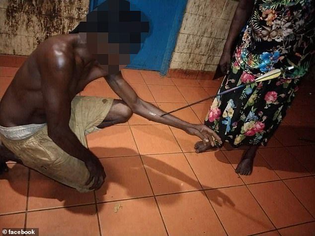
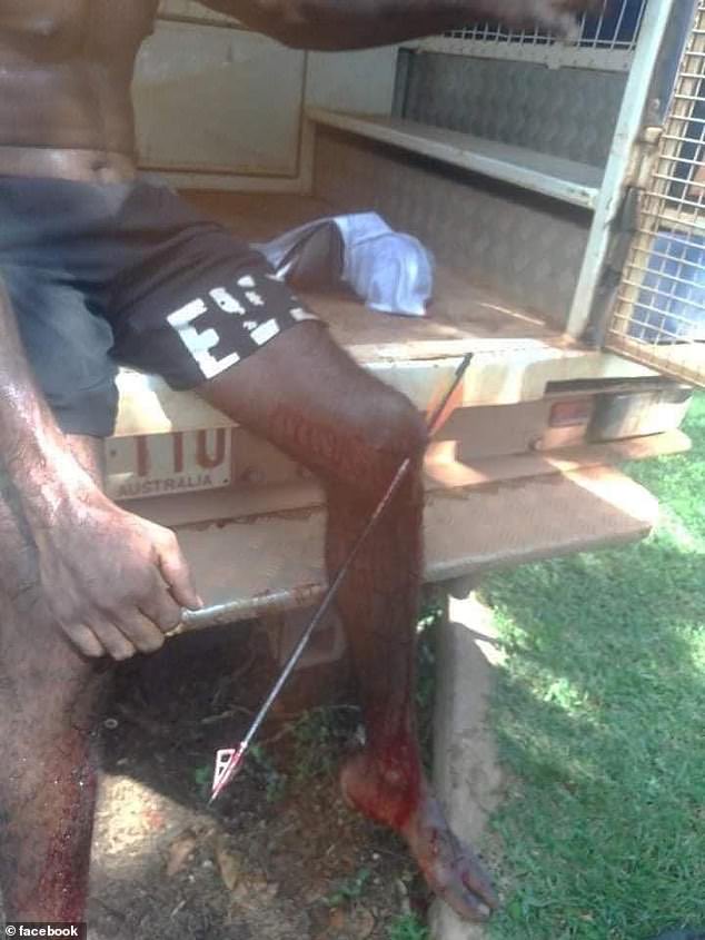
Pics show men with ARROWS pierced through their arms & legs after 20 crossbows were stolen &used in a fight in #Wadeye #NorthernTerritory #Australia
They were stolen from #MitchellsAdventures #Darwin & remote #Aboriginal community has been marred with violence in recent months.


Talking to my broken hearted father about the appalling treatment meted out to Elders whilst we lived in #Wadeye #PortKeats the sneering ignorant patronising paternalism by the govt men. Cost lives, hopes and futures. #AlwaysWas #Indigenous ❤️💛🖤 #auspoll2022
Last Seen Hashtags on Sotwe
Most Popular Users

Elon Musk 
@elonmusk
241.7M followers

Barack Obama
@barackobama
119M followers

Cristiano Ronaldo
@cristiano
114.4M followers

Donald J. Trump
@realdonaldtrump
111.9M followers

Narendra Modi
@narendramodi
107.2M followers

Rihanna
@rihanna
98.7M followers

NASA
@nasa
92.4M followers

Justin Bieber
@justinbieber
91.8M followers

KATY PERRY
@katyperry
90M followers

Taylor Swift
@taylorswift13
83.9M followers

Lady Gaga
@ladygaga
75.4M followers

Virat Kohli
@imvkohli
73.4M followers

Kim Kardashian
@kimkardashian
70.9M followers

YouTube
@youtube
68.8M followers

Neymar Jr
@neymarjr
66.4M followers

Bill Gates
@billgates
65.2M followers

Selena Gomez
@selenagomez
63.1M followers

The Ellen Show
@theellenshow
62.3M followers

CNN
@cnn
61.8M followers

X
@x
60.7M followers