Top Tweets for #Webmapping

Why rebuild your app from zero when your web map already has everything?🗺️💡
ArcGIS Instant Apps inherits pop-ups, bookmarks, charts, and forms directly from your map, no extra configuration needed.
https://t.co/7GYma8bEOY
#Geoawesome #GIS #ArcGIS #InstantApps #WebMapping #Esri


Build powerful web maps without vendor lock‑in. Learn how open source tools like OpenStreetMap, Leaflet, and Python libraries let you create flexible, transparent mapping apps at zero cost. #WebMapping #OpenSource #GIS
🔗 https://t.co/7uVpEdNgpV


🗺🌐 En esta entrada se muestra como trabaja la API de desarrollo 𝗠𝗮𝗽𝗯𝗼𝘅 para trabajar con información 3D.
𝘚𝘪𝘨𝘶𝘦 𝘭𝘦𝘺𝘦𝘯𝘥𝘰: https://t.co/tRmPeyPfy3
#WebGIS #SIG #Mapbox #WebMapping
Build powerful web maps without vendor lock‑in. Learn how open source tools like OpenStreetMap, Leaflet, and Python libraries let you create flexible, transparent mapping apps at zero cost. #WebMapping #OpenSource #GIS
🔗 https://t.co/7uVpEdNgpV


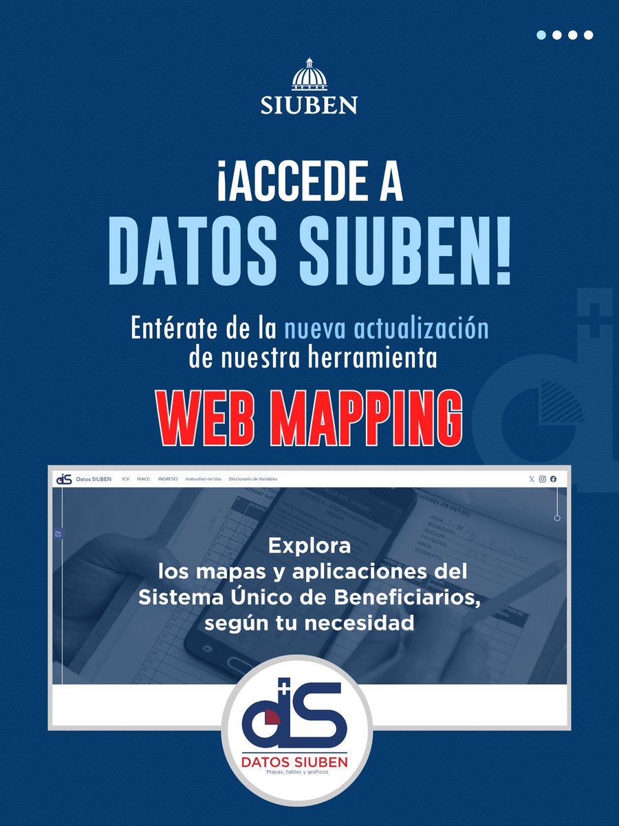
Presentamos una nueva actualización de #DatosSIUBEN #WebMapping.
Esta versión incorpora mejoras en la navegación, acceso directo a los principales índices generados por el SIUBEN, nuevas categorías temáticas y vínculos entre mapas e indicadores.
#SIUBEN #DatosParaDecidir


CesiumJS 1.142 boosts large-scale rendering & vector tiles with 3D Tiles. QGIS 4.0.3/3.44.11 polish stability & forms. GeoServer 2.28.4 fixes XXE & improves ops. 🗺️ #GIS #OpenSource #WebMapping


Our new Georeferencer eliminates the technical friction of manual file conversion for five major formats: PNG, JPEG, PDF, TIFF, and WebP. It allows you to define the location of your geodata effortlessly.
Find out more: https://t.co/gIl65LMk8H
#MapTiler #Geodata #WebMapping
Build powerful web maps without vendor lock‑in. Learn how open source tools like OpenStreetMap, Leaflet, and Python libraries let you create flexible, transparent mapping apps at zero cost. #WebMapping #OpenSource #GIS
🔗 https://t.co/7uVpEdNgpV


Smart maps. Better conservation.
Web GIS is redefining how we design and manage conservancies.
#GIS #WebMapping #Conservancy #GeoTech #Sustainability #JapakGIS #DigitalMaps #MappingInnovation

🌍 Este curso ofrece al alumno una completa formación y especialización en Web GIS.
🔗 Web: https://t.co/FpDNLv2eeA
💻 Online
📅 8 de abril
🕘 240h
✅ Descuentos
ℹ Inscripción: https://t.co/MMqr6haSuq
📧 [email protected]
#WebGIS #QGIS #leaflet #mapbox #WebMapping #cursos


Limitations: BIM alignment is approximate due to Revit origin discrepancies.Revit materials don't carry over to web cleanly, so colours are assigned manually in code. Production fix planned.
#WebMapping #GIS #ThreeJS #PointCloud #BIM #Photogrammetry #Revit
The map runs entirely in the browser.
Upload a CSV file with launch data and the map populates instantly, no backend needed.
There’s also a built-in demo dataset if you want to explore the interface before uploading your own.
#GIS #WebMapping #Leaflet

🏫 Own your campus maps & data! Join the ISPRS 2026 full-day tutorial on web-based campus routing & event management using open-source GIS.
Limited spots, register or update now!
https://t.co/ukbz1EpXLe
#WebMapping #GIS #GeoEducation #OpenSource

Now you can make web #maps look as beautiful as an atlas with a few quick clicks. We’ve added professional-quality color ramps and hillshades to our design tool so you can apply them to your map styles. Find out more: https://t.co/VNlRR9v7K1
#WebMapping

Por qué deberías dejar de servir GeoTIFF clásicos y empezar a usar COG⁉️
Comparamos el #GeoTIFF 🆚 #COG orientado al #webmapping.
Crearemos un archivo COG a partir de un TIFF y los insertaremos en un mapa web para ver su comportamiento.
https://t.co/R2U9oFbVBQ


#30DayMapChallenge Day 8: Urban
Inspired by the Morphocode Explorer, I’m building a Freiburg-focused remix using open data.
Tech: OSM, Freiburg Open Data · #Svelte · MapLibre · Turf.js · Tileserver-GL
#Urban #UrbanData #WebMapping #Geospatial #GIS #DataViz
7.5 cm/px aerial imagery of the Netherlands on MapTiler Satellite. From Amsterdam’s canals to the North Sea coastline, every feature is now sharper than ever.
Check the update at https://t.co/tYz4qKkBrB
#AerialImagery #WebMapping


1 BILLION GAUSSIAN SPLATS (or more 🤫) in online maps!
One of the biggest innovations in recent years is coming your way. Want to know more? Join MapTiler Connect on October 21st! https://t.co/HNtzoxTwsj
Data source: Andrii Shramko
#MapTilerConnect #gaussiansplatting #splats
Our Elevation API lets you look up the elevation of a single location, a batch of points, a GeoJSON LineString, or a GeoJSON MultiLineString. Get all the parameters and see how it works here: https://t.co/orQOVE19tG
#WebMapping #GeoAPIs

Incredible 5 cm/px resolution aerial imagery for Prague on the MapTiler Satellite map. From Charles Bridge and Prague Castle to Old Town Square and the Dancing House, see the city in remarkable detail.
Check the update at https://t.co/wLVAPQqXTW
#AerialImagery #WebMapping
Last Seen Hashtags on Sotwe
Most Popular Users

Elon Musk 
@elonmusk
240.2M followers

Barack Obama
@barackobama
119.3M followers

Donald J. Trump
@realdonaldtrump
111.6M followers

Cristiano Ronaldo
@cristiano
109.1M followers

Narendra Modi
@narendramodi
107M followers

Rihanna
@rihanna
97.3M followers

NASA
@nasa
92.1M followers

Justin Bieber
@justinbieber
90.6M followers

KATY PERRY
@katyperry
86.9M followers

Taylor Swift
@taylorswift13
80.7M followers

Lady Gaga
@ladygaga
72.2M followers

Kim Kardashian
@kimkardashian
69.4M followers

Virat Kohli
@imvkohli
68.6M followers

YouTube
@youtube
68.6M followers

Bill Gates
@billgates
63.5M followers

The Ellen Show
@theellenshow
62.5M followers

CNN
@cnn
61.9M followers

Neymar Jr
@neymarjr
61.2M followers

X
@x
60.9M followers

Selena Gomez
@selenagomez
60M followers