Top Tweets for #WorldView3

🔝 Imagen de #Satélite de #Verano de 2024 en #Geoportal 👇🏼
💻 https://t.co/3mcR6wAMT5
🛰️ 2 escenas del satélite #WorldView3
🛰️Fecha de la toma: 2 de julio de 2024
🛰️Resolución espacial: 50 cm
🛰️Resolución radiométrica: 8 bits
🛰️Resolución espectral: 8 bandas
#ServicioGEO
🔝 Imagen de #Satélite de #Verano de 2024 en #Geoportal 👇🏼
💻 https://t.co/3mcR6wAf3x
🛰️ 2 escenas del satélite #WorldView3
🛰️Fecha de la toma: 2 de julio de 2024
🛰️Resolución espacial: 50 cm
🛰️Resolución radiométrica: 8 bits
🛰️Resolución espectral: 8 bandas
#ServicioGEO
🆕 Imagen de #Satélite de #Verano de 2024 en #Geoportal 🔝👇🏼
💻 https://t.co/3mcR6wAMT5
🛰️ 2 escenas del satélite #WorldView3
🛰️Fecha de la toma: 2 de julio de 2024
🛰️Resolución espacial: 50 cm
🛰️Resolución radiométrica: 8 bits
🛰️Resolución espectral: 8 bandas
#NovedadGEO
🆕 Imagen de #Satélite de #Verano de 2024 en #Geoportal 🔝👇🏼
💻 https://t.co/3mcR6wAf3x
🛰️ 2 escenas del satélite #WorldView3
🛰️Fecha de la toma: 2 de julio de 2024
🛰️Resolución espacial: 50 cm
🛰️Resolución radiométrica: 8 bits
🛰️Resolución espectral: 8 bandas
#NovedadGEO

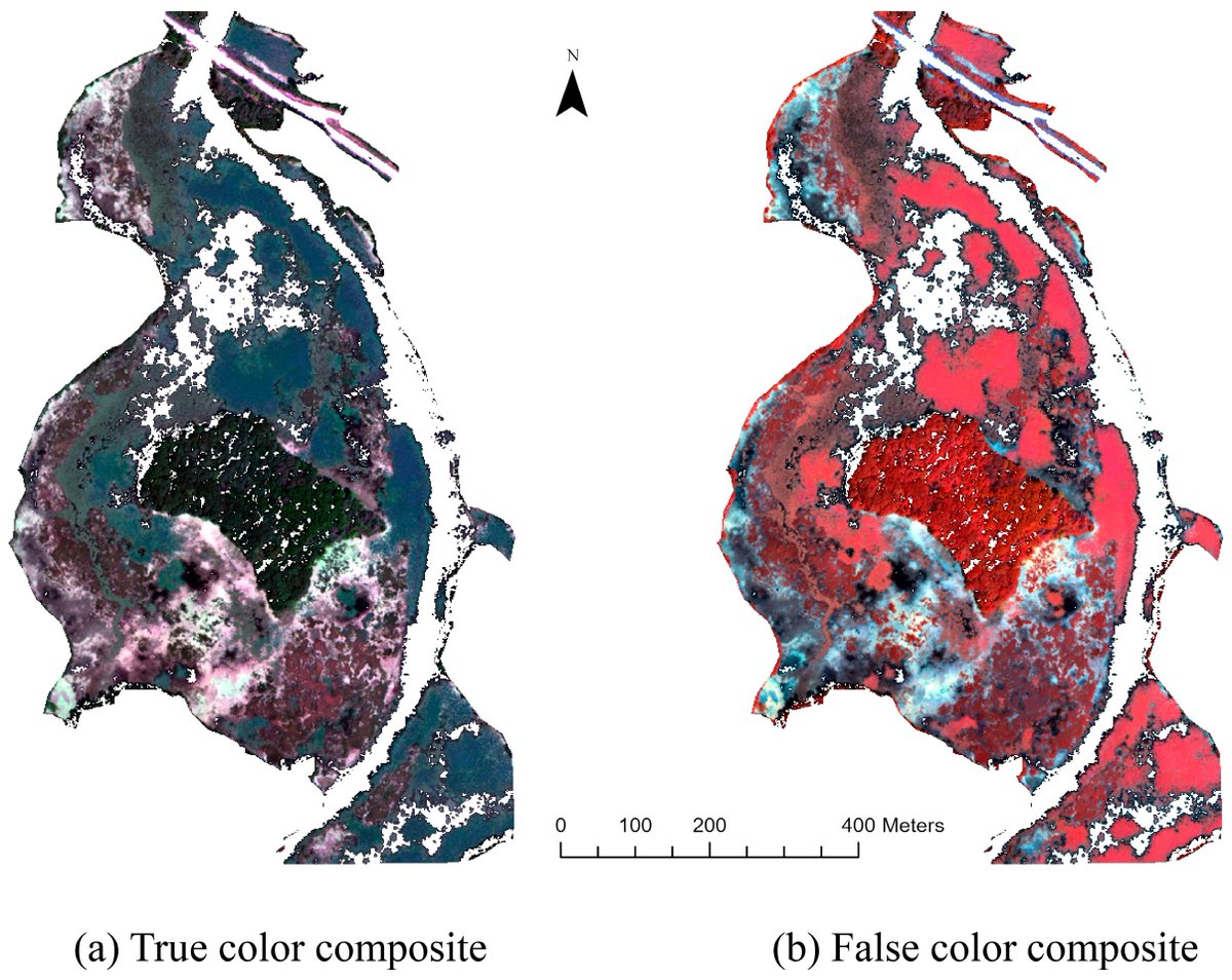
💧🌿🌿 Integrating #UAV-Derived Information and #WorldView3 Imagery for Mapping #Wetland #Plants in the Old Woman Creek Estuary, #USA
✍️ Md Kamrul Islam et al.
🔗 https://t.co/eUPwPnQJiw
🆕 Imagen de #Satélite de #Primavera de 2024 en #Geoportal 🔝👇🏼
💻 https://t.co/GPZr9OrgwJ
🛰️ 3 escenas del satélite #WorldView3
🛰️Fecha de la toma: 6 de junio de 2024
🛰️Resolución espacial: 30 cm
🛰️Resolución radiométrica: 8 bits
🛰️Resolución espectral: 8 bandas
#NovedadGEO


🌍 Discover mineral-rich landscapes from above with @Maxar's #WorldView3! 🛰️ This February 2019 📸 above Belo Horizonte 🇧🇷, showcases its high spatial, spectral, and radiation resolution, perfect for detecting mineral zones.
🔍 Explore product types offered from 2009-02-07 to 2020-12-01: https://t.co/BG3G4NRbDh
📸 @EUSPACEIMAGING
#SatelliteImagery #RemoteSensing


🔔 New article:
Sangjan et al. (@WSUNews) combine optical #WorldView3 and #multispectral #UAV imagery, and #MachineLearning-based yield prediction models, to predict 🌾 wheat crop yields.
🔗 https://t.co/yFvZomnHLe
#IJRS #RemoteSensing #wheat #CropMapping #phenomics


Presentación do mapa forestal de alta resolución do #Inventario #forestal continuo de Galicia #INVEGA. A profesora Julia Armesto da @IngForestalPO compartiu os detalles q permitiron un píxel de 1,20m, empregando 🛰 #Worldview3 e #Sentinel2
👉 Máis info: https://t.co/VSxBloBwH7


🌋 L'un des volcans les plus actifs d’Hawaii, #Kilauea, est entré en éruption cette semaine. A ce jour, les régions habitées ne sont pas menacées. Cette image nocturne du satellite #WorldView3 de @Maxar date du 8 juin 2023 et est 😲, non ?
Bonne journée


#mostdownloaded
📢Estimation of #IndividualTree Biomass in Natural Secondary #Forests Based on #ALS Data and #WorldView3 Imagery
by Yinghui Zhao, Ye Ma, Lindi J. Quackenbush and Zhen Zhen
🔗 https://t.co/NC2q9kyv2N


You’ve probably seen artists’ renderings of #Landsat satellites in orbit... but how about an *actual image* of a satellite in orbit?
Thanks to Maxar, we now have images of Landsat 8 orbiting Earth from the WorldView-3 satellite.
Enjoy! 🛰️
#mosdownloaded
📢 Comparing #Sentinel2 and #WorldView3 #Imagery for #Coastal #BottomHabitat #Mapping in #AtlanticCanada by Kristen L. Wilson, Melisa C. Wong and Emmanuel Devred
🔗 Read the full article: https://t.co/S1Eelz8ept


On the Exploration of Automatic Building Extraction from RGB Satellite Images Using Deep Learning Architectures Based on U-Net https://t.co/hW4TEZ7rvu #mdpitechnologies through @MDPIOpenAccess
#AI #geospatial #geoai #UNet #MachineLearning #DeepLearning #WorldView3 #Satellite
#MostCited #remotesensing
📢Assessing within #FieldCorn and Soybean Yield Variability from #WorldView3, Planet, #Sentinel2, and #Landsat8 #SatelliteImagery
by Sergii Skakun, et al.
@mglbrown
@belenfranchgras
@UofMaryland
@NASAGoddard
@usda_nass
🔗https://t.co/lUBFbEOLuf


Our new blog post on the Aviation-Based Spatial Data Generation by Digital Photogrammetric Methods Using High-Resolution Stereo Satellite Imagery is available
#eTOD #satelliteimagery #stereoanalysis #dsm #worldview3 #pléiades #icao #annex14 #annex15
https://t.co/CRC2mBjSCe
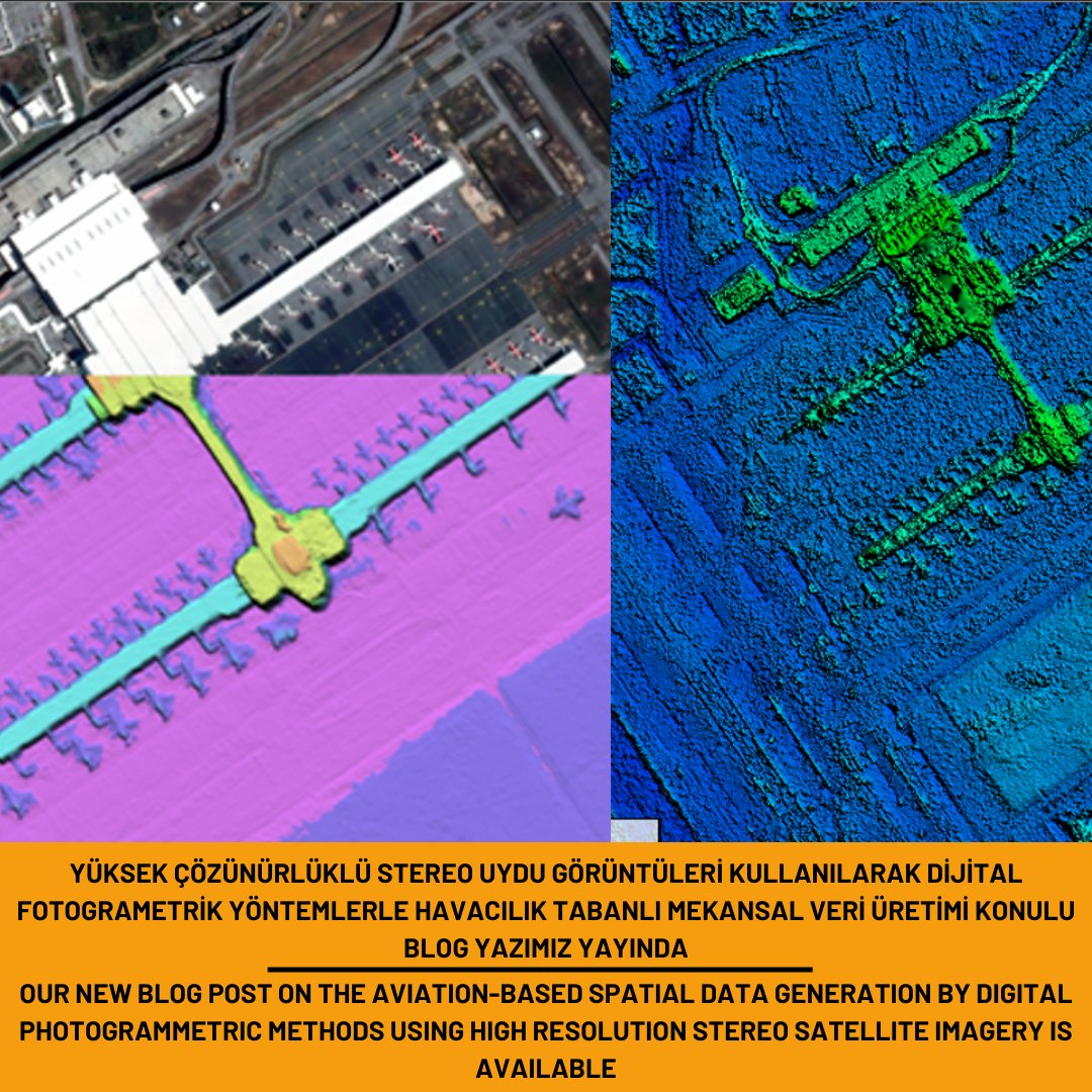
Yüksek Çözünürlüklü Stereo Uydu Görüntüleri Kullanılarak Dijital Fotogrametrik Yöntemlerle Havacılık Tabanlı Mekansal Veri Üretimi konulu blog yazımız yayında.
#eTOD #satelliteimagery #stereoanalysis #dsm #worldview3 #pléiades #icao #annex14 #annex15
https://t.co/CRC2mBjSCe

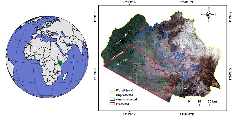
Scientists used HR #WorldView3 integrated with Copernicus #Sentinel2 imagery to map #vegetation in the Greater #MaasaiMara #savanna, a global #biodiversity hotspot in #Kenya. Striking changes to wooded areas may have widespread impacts on #ecosystems. See: https://t.co/qFcmV1JP0S
Last Seen Hashtags on Sotwe
Trends for you
Most Popular Users

Elon Musk 
@elonmusk
240.3M followers

Barack Obama
@barackobama
119.2M followers

Donald J. Trump
@realdonaldtrump
111.6M followers

Cristiano Ronaldo
@cristiano
109.6M followers

Narendra Modi
@narendramodi
106.9M followers

Rihanna
@rihanna
97.4M followers

NASA
@nasa
92.1M followers

Justin Bieber
@justinbieber
90.7M followers

KATY PERRY
@katyperry
87.2M followers

Taylor Swift
@taylorswift13
81M followers

Lady Gaga
@ladygaga
72.5M followers

Kim Kardashian
@kimkardashian
69.5M followers

Virat Kohli
@imvkohli
69.1M followers

YouTube
@youtube
68.6M followers

Bill Gates
@billgates
63.6M followers

The Ellen Show
@theellenshow
62.5M followers

CNN
@cnn
61.9M followers

Neymar Jr
@neymarjr
61.7M followers

X
@x
60.9M followers

Selena Gomez
@selenagomez
60.3M followers