Top Tweets for #rapidmapping

🌊 #EMSR850 – Floods in Albania 🇦🇱
After intense rainfall on 18 Nov, #RapidMapping was requested to provide flood extent and damage assessment emergency mapping.
The estimated impact is indicated in the provided visual. The activation is now closed: https://t.co/Kvz0Ii6lrV

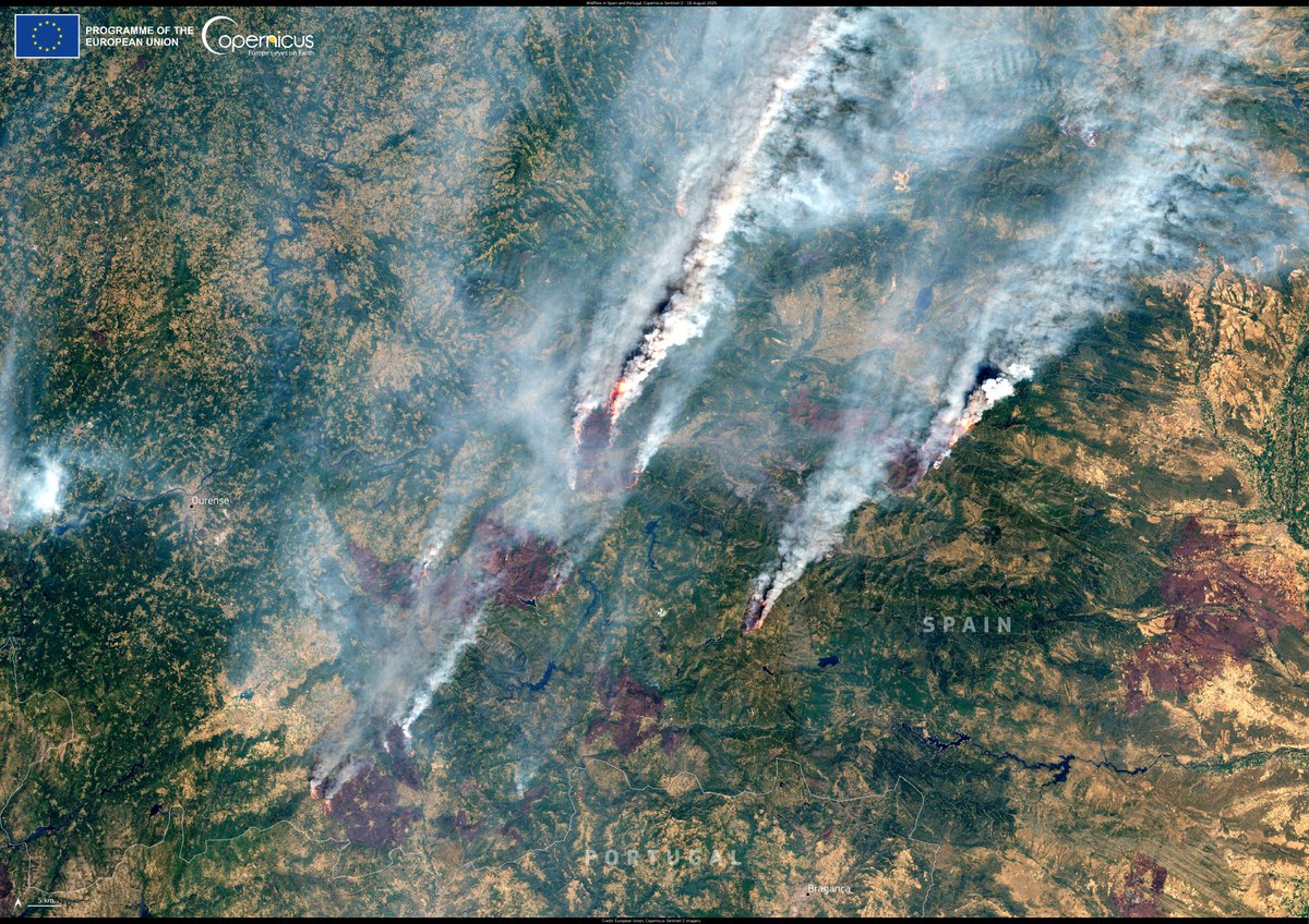
Details of the current activations in Spain and Portugal are available on our #RapidMapping portal:
🔗 https://t.co/dHNAK1yQGz

🚒 Wildfires in Spain 🇪🇸 & Portugal 🇵🇹 have forced evacuations.
Spain already hit its highest annual fire emissions on record, while Portugal nears historic highs.
🛰️ #CopernicusEU support the response.
#ImageOfTheDay

🔥#EMSR837 – #IIFF en el noroeste de España 🇪🇸
🔸9.435 ha quemadas
🔸 47 llamas activas, 11 km de frentes de fuego
🔸 ~30 personas y 41,7 km de vías afectadas en Portilla de la Reina
🛰️ #RapidMapping extensión actualizada del incendio
@CopernicusEMS
🔥#EMSR837 – Wildfires in NW Spain🇪🇸
Our latest map shows:
🔸 9,435 ha burnt
🔸 47 active flames, 11 km fire fronts
🔸 ~30 people & 41.7 km of roads affected in Portilla de la Reina
🛰️ #RapidMapping supports civil protection with updated fire extent:
https://t.co/tJ4Fh9u9r6


El último mapa de @CopernicusEMS muestra:
🔸9.435 ha quemadas
🔸47 focos activos, 11 km de frentes de fuego
🔸~30 personas y 41,7 km de vías afectadas en Portilla de la Reina
🛰️#RapidMapping apoya la protección civil con la extensión actualizada del incendio:
🔥#EMSR837 – Wildfires in NW Spain🇪🇸
Our latest map shows:
🔸 9,435 ha burnt
🔸 47 active flames, 11 km fire fronts
🔸 ~30 people & 41.7 km of roads affected in Portilla de la Reina
🛰️ #RapidMapping supports civil protection with updated fire extent:
https://t.co/tJ4Fh9u9r6
🔥#EMSR837 – Wildfires in NW Spain🇪🇸
Our latest map shows:
🔸 9,435 ha burnt
🔸 47 active flames, 11 km fire fronts
🔸 ~30 people & 41.7 km of roads affected in Portilla de la Reina
🛰️ #RapidMapping supports civil protection with updated fire extent:
https://t.co/tJ4Fh9u9r6
🔥 #EMSR835 – Wildfire in Ipeiros 🇬🇷
Our latest map shows 2,636.8 ha burnt, 43 active flames, and ~650 people potentially affected in the Gymnotopos area.
🛰️ Our #RapidMapping supports damage assessment & emergency response:
https://t.co/9h6mqkOsn0

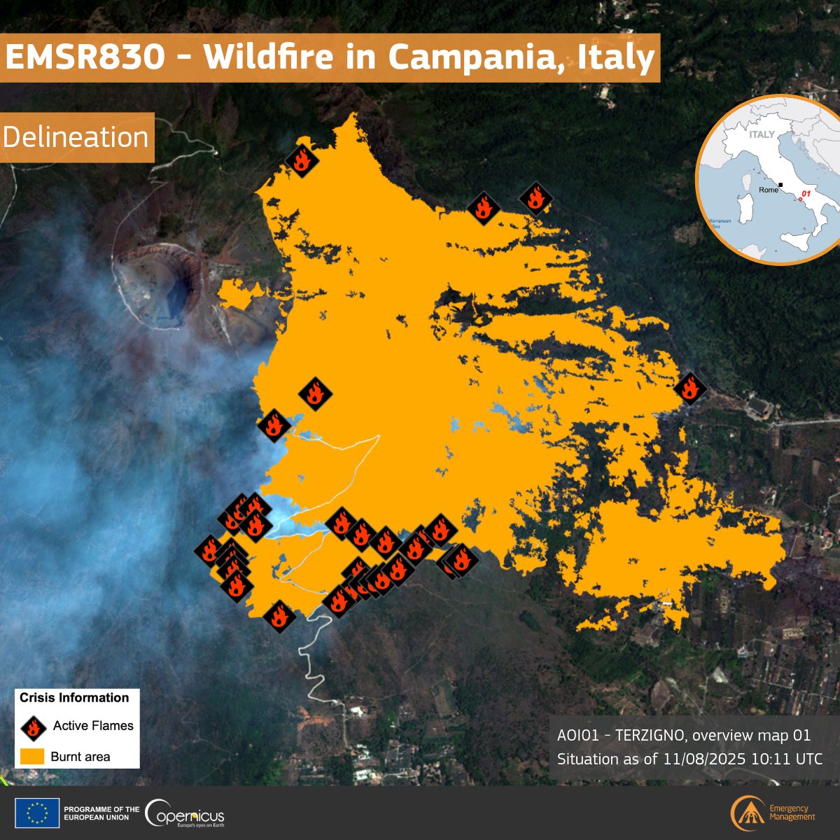
🔥 #EMSR830 – Wildfire near Terzigno, Italy 🇮🇹
Satellite analysis shows 554 ha burned and 32 active flames near densely populated areas by Mount Vesuvius.
Our #RapidMapping is supporting authorities with damage assessment and fire extent mapping.
🔗https://t.co/T1AkcmwdOH
🔥 #EMSR824 – Wildfire in Arouca, 🇵🇹 Portugal
Our #RapidMapping update shows ~5,183 ha burned in the Arouca area.
🚨 300 residents potentially affected
🚗 255 km of roads potentially affected
🏠 Residential, agricultural & forest land impacted
More: https://t.co/804J0Me7ZZ


ℹ️🔥#IRArouca A equipa de #RapidMapping da @CopernicusEMS foi ativada pela @ProteccaoCivil para delinear a extensão deste incêndio 🔥ℹ️
🔥#EMSR824 – Wildfires in Portugal🇵🇹
After days of extreme heat, major wildfires broke out in Arouca & Ponte da Barca, forcing evacuations and deployment of over 2,000 firefighters.
🛰️ Our #RapidMapping service is activated to assess the wildfire extent: https://t.co/804J0Me7ZZ

🔥#EMSR824 – Wildfires in Portugal🇵🇹
After days of extreme heat, major wildfires broke out in Arouca & Ponte da Barca, forcing evacuations and deployment of over 2,000 firefighters.
🛰️ Our #RapidMapping service is activated to assess the wildfire extent: https://t.co/804J0Me7ZZ
🔥 #EMSR821 – Wildfire in Aetos, Peloponnese 🇬🇷
On 26 July, a fast-moving wildfire near Aetos forced evacuations and prompted major firefighting efforts.
#RapidMapping shows:
🔸~636 ha burnt
🔸9.2 km of roads affected
🔸~20 people potentially impacted
🔗https://t.co/8PuVljlWQM

🔥 #EMSR820 – Wildfire in Krioneri, Greece 🇬🇷
#RapidMapping has been activated following a fast-moving wildfire near Krioneri:
🔸 226.9 ha burnt
🔸 ~80 people potentially affected
🔸 11 km of roads impacted
🔸 Evacuations in Krioneri & Drosopigi
🔗https://t.co/EzCiR4P7EY


🇬🇹 #EMSR814 - Sismo en #Guatemala
En el área de Palín, el análisis satelital muestra daños en 4 edificios, 11,8 ha de derrumbes y 17 carreteras bloqueadas.
🛰️ @CopernicusEMS #RapidMapping continúa apoyando los esfuerzos de emergencia.
https://t.co/6J53sCk9la

🇬🇹 #EMSR814 – Earthquake in Guatemala
In the area of Palín, satellite analysis shows damage to 4 buildings, 11.8 ha of landslides, and 17 road blockages.
🛰️ CopernicusEMS #RapidMapping continues to support emergency efforts.
🔗https://t.co/v2xLnF5Ope

🇬🇹 #EMSR814 – Earthquake in Guatemala
In the area of Palín, satellite analysis shows damage to 4 buildings, 11.8 ha of landslides, and 17 road blockages.
🛰️ CopernicusEMS #RapidMapping continues to support emergency efforts.
🔗https://t.co/v2xLnF5Ope
🛰️ When a powerful 7.7 earthquake struck Myanmar in March, rapid satellite mapping helped deliver critical support fast.
Our #RapidMapping service provided detailed damage assessments across 57 areas — guiding emergency teams on the ground.
🔗https://t.co/ZtpoHJdGbf


🗺️#Macarte 🌀 Cyclone #Garance à La Réunion #StoryMap 🌐 #RapidMapping @CopernicusEMS
Retour en cartes 👉 https://t.co/tqFkVufXnF
🗺️ Une #storymap sur le cyclone Chido à #Mayotte, avec les images Pléiades Néo (@Airbus) mis à disposition par @IGNFrance et les ressources mises à disposition par le @GDACS. @CNES #MaCarteIGN
#Copernicus #RapidMapping
Voir en ligne : https://t.co/U2YNx4YhqS

⛈️ The last few days have been marked by the tireless effort of the @CopernicusEMS, led by e-GEOS, due to #Boris storm
🗺️ #RapidMapping generated emergency mapping to assess flood extent in 🇮🇹, 🇩🇪, 🇵🇱, 🇸🇰, 🇷🇴, 🇭🇺,🇦🇹. Additionally, there are flood activations for 🇻🇳 and 🇳🇬


#EMSR748 #Madeira
A equipa de #RapidMapping da @CopernicusEMS divulga o seu sexto produto do incêndio na Madeira.
A 26/08/2024 a área ardida é se 5104ha o que significa que aproximadamente 7% da ilha ardeu neste incêndio que foi ontem dado como extinto
#EMSR748 #IR_Madeira
Yesterday evening, our #MappingTeam delivered its 6th Delineation Product for the #wildfire in #Madeira 🇵🇹
As of 26 August, a total burnt area of 5,104 ha has been detected, covering approximately 7⃣% of the island 🔥
More at 👇
https://t.co/RnxBcipuac

#EMSR748 #Madeira Durante o fim-de-semana a equipa de #RapidMapping da @CopernicusEMS publicou o seu 5º produto de delineação para o #incêndio na Madeira, detectando uma área total ardidade de 5045ha (ha = hectares)
#EMSR748 #IR_Madeira
Over the weekend, our #MappingTeam released its 5th Delineation Product for the #wildfire in #Madeira 🇵🇹, in which a total burnt area of 5,045 ha has been detected🔥
▶️An updated Delineation Product is planned for today
More👇
https://t.co/RnxBcipuac

Trends for you
Most Popular Users

Elon Musk 
@elonmusk
240.7M followers

Barack Obama
@barackobama
119.2M followers

Donald J. Trump
@realdonaldtrump
111.7M followers

Cristiano Ronaldo
@cristiano
110.8M followers

Narendra Modi
@narendramodi
107M followers

Rihanna
@rihanna
97.7M followers

NASA
@nasa
92.2M followers

Justin Bieber
@justinbieber
90.9M followers

KATY PERRY
@katyperry
87.8M followers

Taylor Swift
@taylorswift13
81.6M followers

Lady Gaga
@ladygaga
73.2M followers

Virat Kohli
@imvkohli
70.1M followers

Kim Kardashian
@kimkardashian
69.8M followers

YouTube
@youtube
68.7M followers

Bill Gates
@billgates
64M followers

Neymar Jr
@neymarjr
62.9M followers

The Ellen Show
@theellenshow
62.4M followers

CNN
@cnn
61.9M followers

Selena Gomez
@selenagomez
60.9M followers

X
@x
60.8M followers