@Ryanair My husband and I were due to fly from Venice to Vienna on Friday 19th July. We were at the boarding gate before boarding commenced. Your plane then took off without half of its passengers (including us) and you lost our bags in the process! What are you going to do about this?!
On the first day of Christmas, my true love gave to me... 🎅 #ChristmasEve
Using OS Open Zoomstack and AddressBase Core data, we've mapped 12 songs to celebrate this festive period 👇
"I wouldn’t have been able to do my job without OS data and skills."
The OS Mapping for Emergencies team provide insight and mapping in response to emergency situations for Local Resilience Forums and agencies: https://t.co/o1yQNRajnP
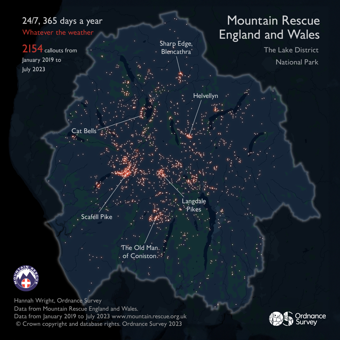
Working with @MountainResqUK, OS Technical Relationship Consultant, Hannah Wright created this dataviz showing the hotspots for call outs for #30DayMapChallenge, Day 9 - Hexagons.
Using OS Open Zoomstack, @QGIS, Mapbox Studio and Adobe Illustrator.
For Day 3 of the #30DayMapChallenge - OS Technical Relationship Consultant, Hannah Wright was inspired by John Nelson's paper cut style for ArcGIS Pro.
This visualisation uses OS Terrain 50 data and was created in ArcGIS Pro, and finished in Adobe Illustrator. #IsleofSkye
For Day 1 of the #30DayMapChallenge - we highlight the extraordinary work of the volunteer @MountainResqUK teams who are on call 24/7, 365 days of the year.
The data visualisation uses OS Open Zoomstack in night style and was created in QGIS, finished off in Adobe Illustrator.
Happy 75th birthday @NHSuk 💙 We're proud to support the great work of the NHS through the #PSGA.
OS work experience student Ruth @TheRomseySchool created this #dataviz of some of the UK's largest hospitals, using OS NGD land use and buildings data: https://t.co/M0SEjQLUY4
"Through my role in the Data Visualisation team, I work with a whole range of customers, helping them to solve problems and make better decisions."
Meet Hannah Wright, as she tells what Embrace Equity means to her, and how she's helping to create a better place 👇
We're celebrating 70 years of @northyorkmoors! 🥳 Can you guess where Hannah took inspiration for her 'remix' of the national park map for the final #30DayMapChallenge?
OS Technical Relationship Consultant Hannah Wright maps #NorthYorkMoors70: https://t.co/9t8FERhRZL
#30DayMapChallenge Day 29 - 'Out of my comfort zone' 🏞️ | OS Technical Relationship Consultant @GeospatialJess maps these three hills in the @peakdistrict nicknamed ‘Dragon’s Back’ - in a 3D diorama view. It was created using OS Terrain 5 data.
The North York Moors National Park celebrated its 70th anniversary yesterday. Using @helenmakesmaps’s tutorial on JoyPlots, I’ve created my own using @OrdnanceSurvey data. Here’s how to do it: https://t.co/6rhiT5HGiN
Our calculations have discovered the three 'norths' will combine for the first time in history this week🧭
True north, magnetic north and grid north will combine at a single point - starting at Langton Matravers, a village just west of Swanage #3Norths
#30DayMapChallenge is back! For Day 1 - Points, OS Cartographer Hannah has been Mapping the Malts 🥃
With over 130 distilleries, Scotland produces more whisky than anywhere else in the world. The 5 main whisky regions are #Highland, #Lowland, #Speyside, #Islay and #Campbeltown.