🌊 Johns Island, Church Creek, SC
High 2:11 AM | Low 8:06 AM
Church Creek on Johns Island is riding a strong incoming tide right now, with high tide peaking at 2:11 AM at an impressive 7.6 feet — that's a significant push of water moving through this tidal river system. After that, the tide turns and drops hard toward a low of just 0.3 feet by 8:06 AM, meaning you'll see nearly 7.3 feet of tidal range and some serious current movement through the creek as the water drains out. That falling tide in the early morning hours is prime time for fishing — redfish, flounder, and trout love to stage near creek mouths and marsh edges as baitfish get swept out with the ebb current. At 51°F, it's a chilly morning on the water, so layer up if you're heading out for a dawn fishing session, and keep an eye on those chances for showers and thunderstorms — lightning on the water is no joke and can move in fast in the Lowcountry. Pro tip: position yourself near a creek mouth or tidal gut just before the low at 8:06 AM — that's when predator fish stack up to ambush baitfish funneling through the outgoing current, and it's one of the most productive windows you'll find on a tidal creek like Church Creek.
https://t.co/hKSpwlFXFs
#JohnsIsland #ChurchCreek #SouthCarolinaFishing #LowcountryFishing #TidalRiver #SCWildlife #KayakFishing
🌊 Santa Cruz River, AZ
Flow: 0 cfs | Stage: 0.95 ft
The Santa Cruz River is running at 0 cfs today — bone dry, which is actually the default state for much of this desert river's course through the Tucson basin, where groundwater pumping and arid conditions have left the channel empty for decades across many reaches. At 0.95 ft stage with no flow, you're looking at a dry or nearly dry sandy wash, so forget paddling — this stretch is firmly in "walk the riverbed" territory today. That said, the Santa Cruz has a fascinating story: historically one of the Southwest's most important riparian corridors, and active restoration efforts have brought cottonwood-willow gallery forests back to life along sections near Tucson, making it a surprisingly rich destination for birding and nature walks even without water. Lace up your boots and explore the floodplain on foot — the riparian habitat supports an incredible diversity of migratory birds, and the exposed sandy channel offers a unique window into desert hydrology. If you're heading out, stay aware of your surroundings as monsoon season can send sudden flash floods roaring down dry washes with little warning, even when skies look clear overhead.
https://t.co/tDbRsjdfd7
#SantaCruzRiver #ArizonaRivers #DesertRiparian #AZBirding #SonoranDesert #FlashFloodAwareness
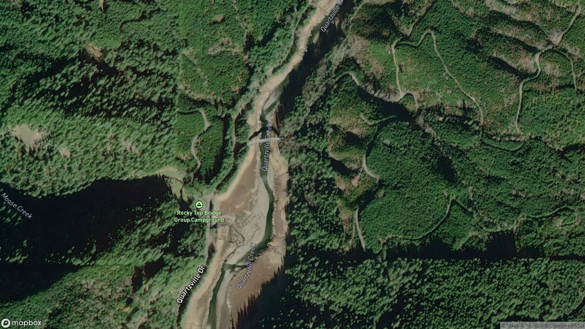
🛶 Green Peter Lake, OR
📍 Quartzville Creek | 🚣 Whitewater Take Out | 🌡️ 58°F
Green Peter Lake on Quartzville Creek serves as a whitewater take-out, making it the finish line for paddlers running the wild and scenic stretch of Quartzville Creek through the Western Cascades - pull out here after your run and soak in that post-rapids satisfaction. At 58°F with partly sunny skies, conditions are classic Pacific Northwest shoulder-season paddling: crisp, beautiful, and rewarding for those who came prepared with a wetsuit or drysuit. This corner of the Oregon Cascades is quintessential PNW - dense Douglas fir and old-growth hemlock framing the creek, with native Chinook and steelhead using these tributaries as part of their storied migration routes through the Willamette watershed. The area is active bear country, so if you're shuttling vehicles or staging gear at the take-out, keep food locked up and make some noise moving through the brush - you're in their neighborhood out here.
https://t.co/Y5Ba57xPOW
#OregonPaddling #QuartzvilleCreek #GreenPeterLake #WhitewaterOregon #PNWKayaking #CascadesAdventure
🌊 Fitzgibbon Cove, AK
High 4:48 PM | Low 10:24 PM
Fitzgibbon Cove is riding an incoming tide right now, building toward a significant high of 13.7 feet at 4:48 PM — that's a substantial tidal swing that commands respect in these remote Alaskan waters. After the high, the tide will ebb back out to 3.3 feet by 10:24 PM, creating a 10-foot-plus drop that generates serious current through coastal passages and inlet channels. For kayakers and small boaters, the window around high tide offers the best conditions for exploring the cove's shallower reaches and rocky shorelines before the ebb current picks up strength. Weather data isn't available for the area right now, but this is Alaska — cold water is a given year-round, hypothermia sets in fast, and with limited cell service and emergency response far away, a dry suit and a solid float plan filed with someone onshore aren't optional, they're survival basics. Pro tip: if you're fishing, the hour before and after the high tide change at 4:48 PM is prime time for halibut and rockfish to feed aggressively along the drop-offs — and keep your eyes on the treeline, because brown bears work these shorelines hard, especially near any salmon-bearing streams draining into the cove.
https://t.co/4lLyTXE9vc
#FitzgibbonCove #AlaskaTides #CoastalAlaska #AlaskaKayaking #TidalFishing #AlaskaWilderness
🛶 Take Out, PA
📍 Loyalsock Creek | 🚣 Whitewater Take Out
This take-out on Loyalsock Creek is your finish line after running one of Pennsylvania's most celebrated whitewater runs — a critical piece of logistics that makes the whole shuttle puzzle work for paddlers tackling the creek's legendary rapids. The Loyalsock is a northeast gem, offering everything from punchy Class II-III boulder gardens to technical drops that demand respect, making this take-out a welcome sight after a big day on the water. The surrounding Loyalsock State Forest is stunning Pennsylvania hill country — hemlocks and hardwoods crowding the gorge walls, native brook trout holding in the cold, clear pools, and that unmistakable northeast creek character that feels wild even though civilization is never far. Make sure your shuttle is dialed in before you put on — confirm your vehicle is staged here and note the access road conditions, as seasonal rains and spring runoff can make dirt roads to creek access points surprisingly rough on the Loyalsock corridor.
https://t.co/Xbo47d98V0
#LoyalsockCreek #Pennsylvania #WhitewaterPaddling #PAKayaking #CreekBoating #NortheastPaddling
🌊 Chattahoochee River, GA
Stage: 5.51 ft
The Chattahoochee is sitting at 5.51 ft and holding steady — conditions are stable and predictable today, which is exactly what you want on a river this size. As a major order-8 waterway, the 'Hooch has the muscle to handle powerboats, experienced kayakers, and anglers alike, and stable stage means no surprise currents or rapidly changing sandbars to catch you off guard. This is a great day to get out on the water, whether you're launching a bass boat, paddling the popular stretch through Atlanta's metro parks, or fishing for the striped bass and shoal bass that make this river a Georgia treasure. One logistics note: the Chattahoochee runs through a mix of urban, suburban, and wilder stretches, so know your put-in and take-out points ahead of time — some access points get crowded on calm days like this. And as always on Georgia waterways, give the banks a scan before you step out of the boat — alligators are present in the lower sections and love a quiet, stable day just as much as you do.
https://t.co/cmmy9S0XTu
#Chattahoochee #HoochLife #GeorgiaRivers #GAPaddling #ShoalBass #KayakGeorgia
🌊 Gibbon Anchorage, Green Island, AK
High 4:10 AM | Low 10:23 PM | Waves 2.6ft ESE
Gibbon Anchorage at Green Island is riding out the long stretch between tides right now — with the next high at 4:10 AM (13.2 ft) and the previous low still well behind us, the water is in its incoming phase through the overnight hours, building toward that significant high. A 13+ foot tidal range is no joke in Southeast Alaska, so expect strong flood currents pushing through the anchorage as you approach the early morning hours — not the time to be repositioning a vessel without careful planning. Conditions offshore are running 2.6 ft waves out of the ESE with a short 6-second swell period, earning a Poor surf rating, and while that's not dramatic by open-ocean standards, combined with Alaska's near-freezing water temperatures, this is absolutely no place for casual water recreation — cold water incapacitation can set in within minutes here. This is deep wilderness coastline with limited to no cell service, no nearby emergency services, and active brown bear populations along the shoreline, so any shore landings or beachcombing need to be treated as serious backcountry expeditions. Pro tip: if you're fishing or transiting this area, time your movements around the slack water window near 4:10 AM — the brief pause between flood and ebb gives you the calmest current conditions and often triggers excellent bottomfish activity as baitfish get repositioned by the tidal shift.
https://t.co/BTbLefojmQ
#GibbonAnchorage #AlaskaWaters #SoutheastAlaska #AlaskaTides #GreenIsland #AlaskaFishing
🌊 Little Cahaba River, AL
Flow: 142 cfs | Stage: 2.11 ft
The Little Cahaba is running at 142 cfs — well below its annual mean of 427 cfs — which means you're looking at a low, intimate float with plenty of shallow riffles and exposed gravel bars that'll require some maneuvering and possibly dragging your boat through the skinnier spots. That said, this is actually a beautiful way to experience one of Alabama's most ecologically rich rivers; the slower pace lets you soak in the stunning limestone shoals and diverse aquatic life that make the Little Cahaba a biodiversity hotspot — it's one of the most species-rich rivers of its size in North America, home to rare mussels, darters, and exceptional smallmouth bass fishing. Kayaks, canoes, and SUPs are your best bet today — leave the bigger recreational boats at home — and anglers will love the low, clear water for sight-fishing those shoal-hugging smallies and redeye bass. As always in Alabama river country, give the banks a good scan before you step out to stretch or wade — gators are present in this watershed and low, warm-season flows mean more exposed shoreline where they like to sun. Stable conditions make for a predictable, relaxed outing, so this is a great day to go slow, explore the gravel bars, and appreciate why this little river punches way above its weight.
https://t.co/cuWEXAU0tX
#LittleCahabaRiver #Alabama #AlabamaRivers #KayakAlabama #SmallmouthBass #HowsYourRiver
🛶 Mississippi River, MS
📍 Mississippi River | 🚣 Boat Ramp
The Mississippi River boat ramp puts you on one of the most iconic waterways in North America — a wide, powerful river with serious current and serious character. This launch is built for trailered boats, making it ideal for motorized fishing rigs, pontoons, or anyone looking to cover water on the mighty Mississippi. The scenery is quintessential Deep South: cypress draped in Spanish moss, muddy banks, and backwater sloughs that hold catfish, crappie, largemouth bass, and alligator gar the size of your arm. This is gator country, plain and simple — keep pets and kids away from the water's edge, especially at dawn and dusk when big reptiles are most active near the launch ramp and shoreline. Before you back the trailer down, scout the ramp conditions and always let someone know your float plan — the Mississippi demands respect from every boater who puts in.
https://t.co/NhlVVxXrCG
#Mississippi #MississippiRiver #MississippiBoating #CatfishingMS #DeepSouthWaters #GatorCountry
🌊 Club Bridge Creek ent., Trenchards Inlet, SC
High 11:54 PM | Low 5:13 PM
The tide is heading out at Club Bridge Creek entrance in Trenchards Inlet, with low tide arriving at 5:13 PM at a notable -0.6 ft — that's a negative tide, meaning water levels will drop below the average low water mark, exposing creek edges and marsh structure that are usually submerged. After that, the tide turns and builds steadily toward a solid 7.8 ft high tide at 11:54 PM, so expect strong incoming currents through the inlet and up the creek as the evening progresses. That kind of tidal range (over 8 feet of movement) drives serious current through these Lowcountry waterways, making Trenchards Inlet a dynamic and productive fishery — redfish, flounder, and speckled trout love to stage along the creek edges and drop-offs as the tide transitions. Kayakers and canoeists should plan their paddles around slack water near the 5:13 PM low, as the incoming flood that follows will push strong currents through the creek mouth — paddling with the tide rather than against it will make a big difference. Pro tip: that negative low tide is your best window to sight-fish shallow grass edges for redfish tailing in just inches of water — get there early and move quietly for the best shot at these spooky fish!
https://t.co/Wvaeg5AzYl
#TrenchandsInlet #SouthCarolinaWaters #LowcountryFishing #SCKayaking #RedfishSC #HowsYourRiver
🛶 Buckatunna Chicora Clara Road Bridge, MS
📍 Chickasawhay River | 🚣 Boat Ramp
The Buckatunna Chicora Clara Road Bridge boat ramp drops you onto the Chickasawhay River — a classic Mississippi blackwater system winding through the longleaf pine and cypress country of the Piney Woods region, and one of the state's most underappreciated waterways. This ramp is built for trailered boats, making it a solid put-in for bass anglers, crappie fishermen, and anyone looking to explore the tannin-stained backwaters and oxbows that define this stretch of river. The Chickasawhay is prime largemouth bass and catfish territory, and the cypress-lined banks draped in Spanish moss give it that deep-South, slow-water character that makes paddlers and motorboaters alike feel like they've stepped back in time. One critical heads-up before you step off the ramp — this is active alligator habitat, so keep a sharp eye at the water's edge, keep kids and dogs close, and never linger near the bank at dawn or dusk when gators are most active and hardest to spot.
https://t.co/mD8Dd7bOaU
#ChickasawhayRiver #MississippiOutdoors #BlackwaterFishing #BoatLaunch #PineyWoodsMS #GatorCountry
🌊 Cuyahoga River, OH
Flow: 361 cfs | Stage: 3.35 ft
The Cuyahoga is running at 361 cfs with a stage of 3.35 ft and holding steady — a solid, workable flow for this mid-size river that gives you enough water to move without the pushy current that can make things dicey. Conditions are looking good for kayakers and canoeists who want a manageable paddle through one of Ohio's most historically significant waterways, and bank anglers will find this a comfortable level to wade the shallower margins targeting smallmouth bass and channel catfish. Keep in mind the Cuyahoga's reputation for ag runoff — especially in the upper stretches — so check water clarity before you commit to a full day on the water, and if you've had recent rain in the watershed, give it a day or two to flush. This is the river that famously caught fire in 1969 and helped spark the Clean Water Act, and today it stands as one of America's great environmental comeback stories — paddling it now feels like a victory lap for conservation, with herons working the banks and smallmouth lurking in every riffle.
https://t.co/JJGRDRtvBd
#CuyahogaRiver #Ohio #OhioRivers #KayakOhio #SmallmouthBass #CuyahogaValley
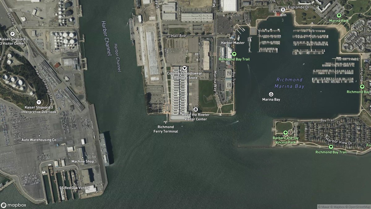
🌊 Richmond Inner Harbor, CA
High 2:16 AM | Low 8:03 PM | Waves 2.2ft WNW
Richmond Inner Harbor is currently on the falling tide, heading toward tonight's low at 8:03 PM (1.7 ft) — so expect water levels to continue dropping through the evening hours, which can expose some interesting shoreline features around the harbor edges. With the next high tide not arriving until 2:16 AM at 6.4 ft, you've got a solid window of outgoing tidal flow this afternoon and evening, which means kayakers and paddleboarders should be mindful of current direction if venturing toward the bay. Waves are running a modest 2.2 ft out of the WNW with a 1.9 ft swell at 6 seconds, earning a "Poor" surf rating — not the day for riding waves, but perfectly fine for a casual paddle or a peaceful afternoon on the water. At a beautiful 75°F and full sunshine, conditions are genuinely lovely for being out on the harbor — just keep in mind that the outgoing current can create some pull near the harbor mouth as the tide drains. Pro tip: if you're fishing the harbor, the hour or two right before tonight's low tide is prime time — baitfish concentrate in the shallower water and striped bass and halibut tend to feed aggressively as the current slows toward slack.
https://t.co/C2pajdNb9Y
#RichmondInnerHarbor #CaliforniaTides #SanFranciscoBay #BayAreaPaddling #HowsYourRiver #CoastalCalifornia
🌊 Platte River, MI
Flow: 135 cfs | Stage: 1.29 ft | Air: 32F | Mostly Cloudy then Light Rain Likely
The Platte River in Michigan is running at 135 cfs with a stage of 1.29 ft and has been stable over the last 24 hours — solid, fishable conditions for this mid-size stream, though the real story today is that 32°F air temp. With freezing air and light rain moving in, this is firmly a **shore and waders day** — hypothermia risk is real if you take an unexpected swim, and cold, wet conditions can turn dangerous fast on a river that can feel remote in its wooded stretches. That said, the stable flow means predictable currents and clear lines for trout anglers — the Platte is one of Michigan's beloved steelhead and salmon rivers, and this time of year you might find late-run fish holding in the deeper pools and seams. Dress in full neoprene or dry gear if you're wading, and let someone know your access points before you head out — cell service can be spotty along the wooded corridor. The Platte's clear, cold water and its connection to Platte Lake and Lake Michigan make it a truly special piece of Michigan river country — worth every cold finger to experience it.
https://t.co/QHjHDy4H26
#PlatteRiver #MichiganFishing #PureMichigan #SteelheadFishing #WinterFishing #HowsYourRiver
🛶 Red Cedar River Access, MN
📍 Red Cedar River - Tainter Lake | 🚣 Boat Ramp
The Red Cedar River Access gives you solid boat ramp entry onto the Red Cedar River as it flows into Tainter Lake, making this a versatile launch point for everything from bass fishing to a leisurely cruise across the lake's open water. Tainter Lake is a reservoir gem in this corner of Minnesota, offering the kind of calm, expansive water that trailered boats love — think pontoons, fishing rigs, and bass boats all sharing the same put-in. This is classic Midwest river-lake country where largemouth and smallmouth bass, walleye, and northern pike are the main targets, with agricultural fields and wooded shorelines framing the scenery in that quintessential prairie-meets-lake Minnesota way. Before you back the trailer down, check current ramp conditions locally — Minnesota access sites can see seasonal closures and fluctuating water levels, so a quick call to the regional DNR office or a chat with the bait shop in town can save you a wasted trip.
https://t.co/omwtKyWCOi
#RedCedarRiver #TainterLake #Minnesota #MNFishing #BoatLaunch #MidwestFishing
🌊 Hana, HI
High 5:16 PM | Low 10:55 PM | Waves 4.3ft ENE
Hana's tide is on its way up toward a 2.3 ft high at 5:16 PM, so you've got a rising water window right now — great for swimmers and snorkelers as the incoming tide flushes in cleaner, clearer water along the shoreline. After that peak, the tide drops to a low of 0.4 ft by 10:55 PM, which will expose some interesting reef and rocky areas for late-evening beachcombing if you're feeling adventurous. Waves are running 4.3 ft out of the ENE with a 2.6 ft swell at 9-second intervals, earning a **Fair** surf rating — not epic, but definitely rideable for intermediate surfers who know Hana's breaks. Pro tip: that incoming tide through high at 5:16 PM is your sweet window for paddleboarding and kayaking before the ebb kicks in and currents pick up — Hana's coastline is rugged and remote, so always paddle with a buddy, stay aware of surge on the lava shelves, and give yourself plenty of time to get back to shore before dark.
https://t.co/Hhf6LzkQBZ
#HanaHawaii #Maui #MauiSurf #HawaiiTides #HawaiisYourRiver #HawaiiOcean #MauiCoast #SurfHawaii
🛶 Access above Silache, OR
📍 Siletz River | 🚣 Whitewater Access
The Access above Silache puts you on one of Oregon's most beloved coastal whitewater runs, the Siletz River, at a classic put-in point for paddlers looking to ride the technical drops and swift current that define this legendary stretch. This is a whitewater paddler's access first and foremost — expect moving water, read-and-run rapids, and the kind of river character that rewards experienced kayakers and canoeists who know how to handle Pacific Northwest flows. The Siletz drains the lush Coast Range rainforest, so you're paddling through a cathedral of old-growth ferns, mossy canyon walls, and towering conifers with a real chance of spotting native Coho and Chinook salmon holding in the deeper pools — it's as scenic as Pacific Northwest rivers get. This is confirmed bear country, so if you're staging gear at the put-in or doing a shuttle, keep food locked in your vehicle and make some noise moving around the access area, especially in the brushy margins. Check current gauge levels before you go — the Siletz can swing dramatically with coastal rainfall, and what's a fun intermediate run at moderate flows becomes a serious commitment when the river is running high and pushy.
https://t.co/sCBZu3iSRu
#SiletzRiver #OregonWhitewater #PaddleOregon #CoastRangeKayaking #OregonRivers #WhitewaterKayaking
🌊 Pound River, VA
Flow: 547 cfs | Stage: 3.34 ft
The Pound River is holding steady at 547 cfs and 3.34 feet — a stable, workable flow for this southwestern Virginia gem tucked into the heart of the coalfields region. For a mid-size stream order 6 river, this is a solid recreational level that opens the door for kayaking, canoeing, and wade fishing without the headaches of dragging over exposed rock or fighting pushy flood currents. Without current water or air temp data, dress in layers and check conditions locally before you head out — late season swings in the Virginia highlands can surprise you, and it's always smart to assume the water is cooler than you'd like. The Pound River flows through Wise County near Pound, Virginia, a rugged, culturally rich corner of the Appalachians where the scenery is all ridgelines, hardwood hollows, and quiet water — smallmouth bass and rock bass are the local stars here, and they love this kind of steady, clear-ish flow. Parking and access can be tight along some stretches, so scout your put-in and take-out ahead of time and let someone know your float plan before you push off.
https://t.co/6OnUlCfa0Q
#PoundRiver #Virginia #SWVirginia #SmallmouthBass #AppalachianPaddling #VAOutdoors
🌊 Florence, Siuslaw River, OR
High 2:49 AM | Low 8:49 PM
The Siuslaw River at Florence is riding the outgoing tide right now, with the next low tide hitting at 8:49 PM at just 0.9 feet — a solid tidal drop that will concentrate fish in deeper channel areas and get the current moving nicely through the river bends. After that low, the tide will begin building back toward tonight's high of 7.2 feet at 2:49 AM, so if you're planning an evening session, expect currents to shift and start pushing upriver as the night progresses. That 7.2-foot high is a healthy tidal swing for the Siuslaw, meaning water levels and current strength will be significant — kayakers and canoeists should be mindful of how quickly the river's character can change with that kind of tidal influence. At 58°F with a slight chance of rain showers, it's classic Oregon coast weather — perfectly fishable, but dress in waterproof layers and bring a dry bag for your gear. Pro tip: the falling tide window heading into this evening's low is prime time for salmon and steelhead anglers working the deeper holes — baitfish get pushed around by the dropping water and the bite can really fire up, so get your lines in before that 8:49 PM low and plan your takeout before the incoming current picks up strength after dark.
https://t.co/znRF4c7ny0
#SiuslawRiver #Florence Oregon #OregonFishing #TidalRiver #KayakOregon #OregonCoast
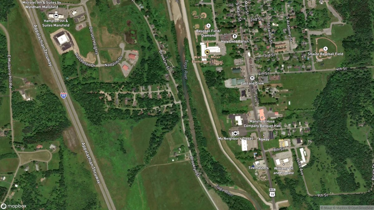
🌊 Tioga River, PA
Flow: 437 cfs | Stage: 1.54 ft | Water: 40F | Air: 33F | Rain Showers Likely then Cloudy
The Tioga River is running at 437 cfs with a stage of 1.54 ft and has been stable over the last 24 hours — a reasonable late-season flow for this order-7 river in north-central PA, but today is firmly a **shore day**, not a water day. With water temps at a dangerous 40°F and air temps hovering at 33°F with rain showers likely, hypothermia can set in within minutes of any unexpected immersion — even a brief wade or a capsized kayak could turn serious fast. Your best bet today is lacing up the boots and walking the banks — the Tioga corridor offers some stunning late-fall scenery through the Pennsylvania Wilds, and with flows stable and clear-ish, this is actually a great time to scout runs and access points for when conditions improve. The Tioga drainage is legendary among Pennsylvania trout anglers — wild brown and brook trout thrive in these cold-water tributaries — so file away what you see today for a spring return trip when the water warms and the hatches start. If you absolutely must be near the water, dress in wool or synthetic layers, tell someone your exact location, and treat every slick rock on that bank like it's trying to put you in the river.
https://t.co/Sej8RwutvJ
#TiogaRiver #PennsylvaniaWilds #HowsYourRiver #ColdWaterSafety #PAFishing #PANature