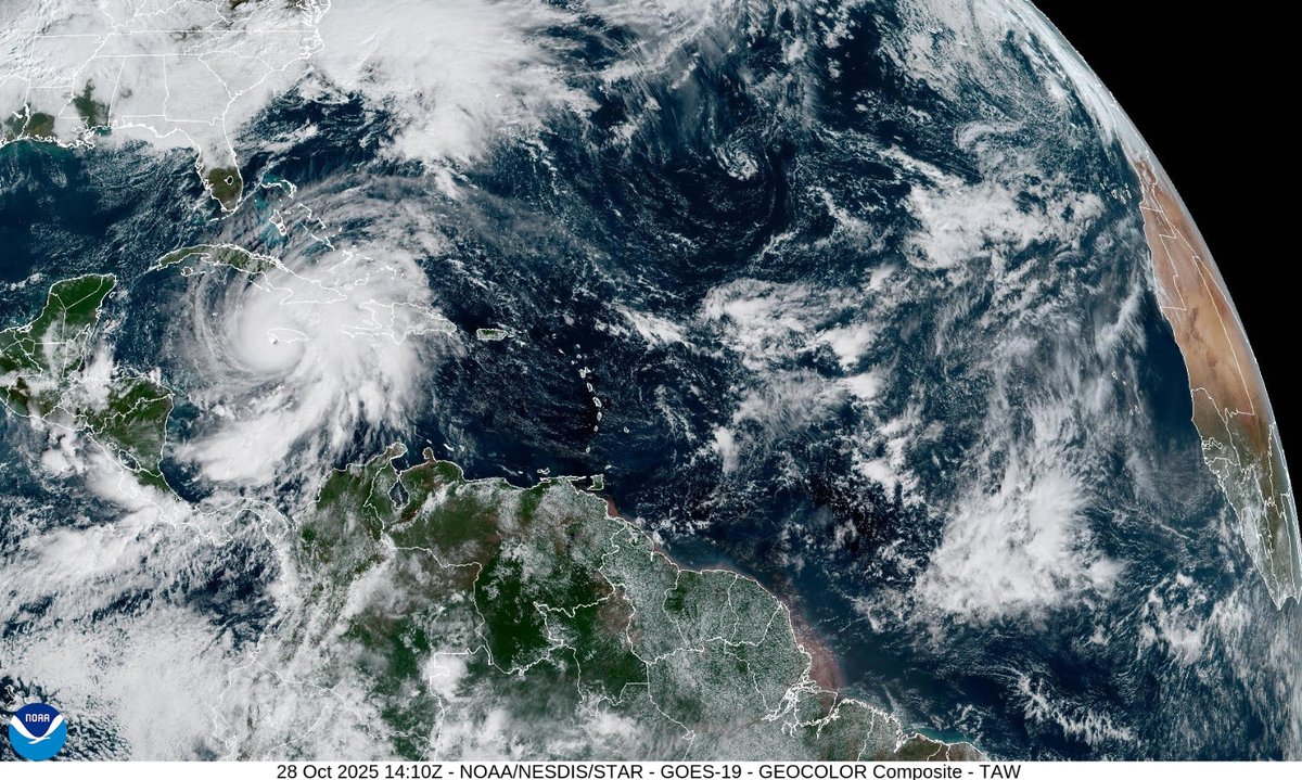
Hurricane Melissa's maximum sustained winds increased to 185 mph as it approaches Jamaica. The minimum central pressure is down to 892 mb. https://t.co/hvGmAFYpN3
Potential Tropical Cyclone Nine has formed. Tropical storm watches out for portions of the Bahamas. Parts of U.S. Southeast coast in forecast cone. NHC notes in discussion: "higher-than-usual uncertainty in the forecast track" https://t.co/mTWyC6Q0NF
NHC gives broad area of low pressure in the southwestern Caribbean a 60% off developing in the next 48 hours and an 80% chance of developing in the next 7 days https://t.co/2Xdodadot6
Tiny Hurricane Oscar has max sustained winds of 85 mph and a min pressure of 987 mb with the 5 pm EST update. The hurricane winds extend outward only 5 miles from the center. https://t.co/2XdodadWiE
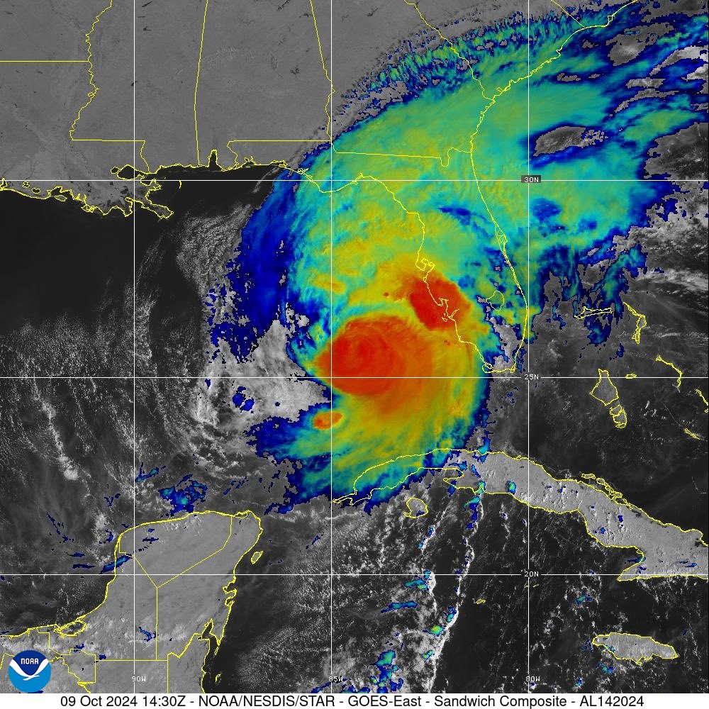
Hurricane Milton rips open roof of Tropicana Field stadium https://t.co/jWzpQp82E9
Local residents reportedly heard the noise of ripping fabric https://t.co/JICE2m4Zwo
Milton wind field growing larger. 11 am EDT size:
"Hurricane-force winds extend outward up to 35 miles (55 km) from the center and tropical-storm-force winds extend outward up to 175 miles (280 km)."
bigger than 12 hours ago > https://t.co/qmK6EYfOMD
Hurricane Milton a little larger wind field than before: "Hurricane-force winds extend outward up to 30 miles (45 km) from the center and tropical-storm-force winds extend outward up to 140 miles (220 km)." https://t.co/juds6HNTUk
1100 AM EDT Wed Oct 09 2024
...TORNADIC SUPERCELLS FROM #MILTON BEGINNING TO SWEEP ACROSS THE
SOUTHERN #FLORIDA PENINSULA...
...THE TIME TO PREPARE, INCLUDING #EVACUATE IF TOLD DO SO, IS
QUICKLY COMING TO AN END ALONG THE FLORIDA WEST COAST...
#FL#hurricane#hurricanemilton
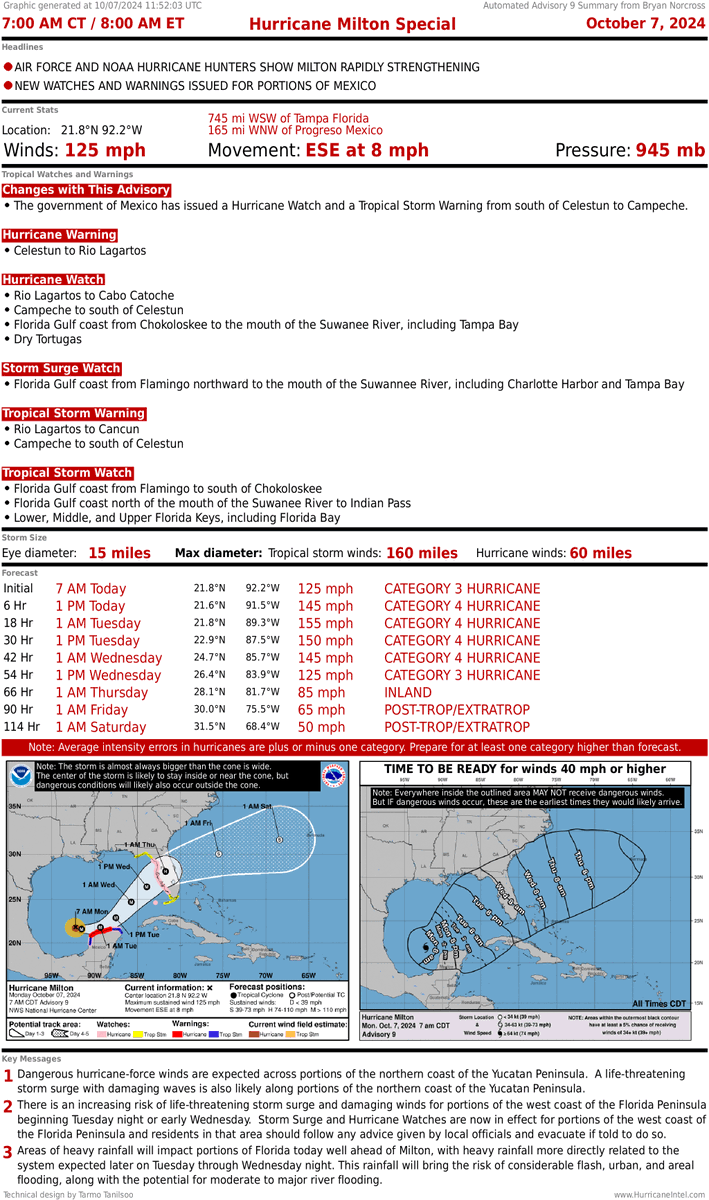
As I sign off for the night #Milton continued to attempt another sub 900mb run within ~24 hours of landfall. This storm has everything going for it as it continues to push out Cat5 storm surge with a guaranteed expanding wind field expected at landfall to push that surge into the coast. Not much here to prevent the inevitable and likely our second consecutive retired USA impact named storm. This has happened before in 1964 with Cleo and Dora. Thank you @philklotzbach
If you aren't taking the storm serious you need to ask yourself why. Focus on the best possible outcome for your family and friends with this inevitable horror that is about to take place in Florida. Time is running out.
Hurricane Milton a little larger wind field than before: "Hurricane-force winds extend outward up to 30 miles (45 km) from the center and tropical-storm-force winds extend outward up to 140 miles (220 km)." https://t.co/juds6HNTUk
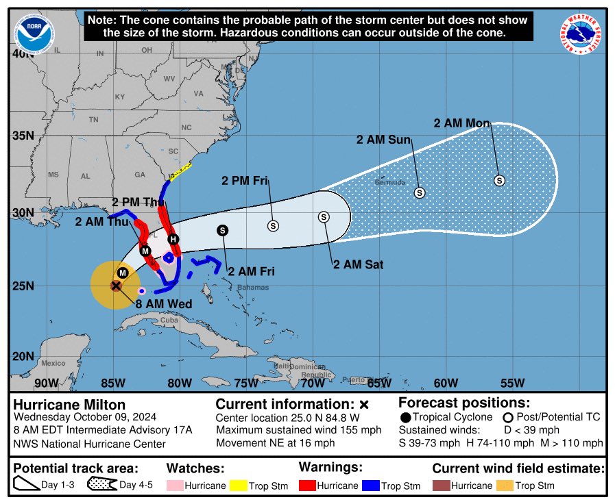
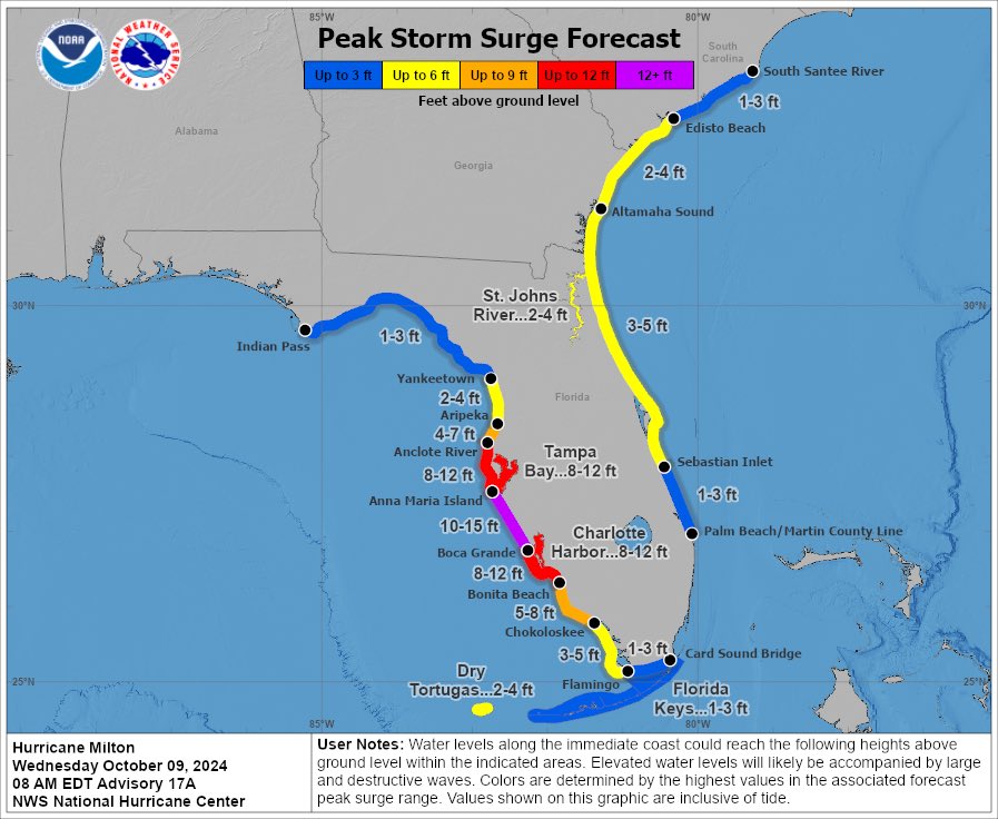
Hurricane Milton has maximum sustained winds of 160 mph and a minimum pressure of 915 mb with the 10 pm CDT update from the NHC. Forecast continues to call for Milton to make landfall as a major hurricane with a "large area of destructive storm surge" https://t.co/dF5DAhKkHZ
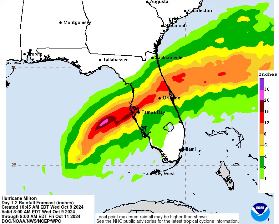
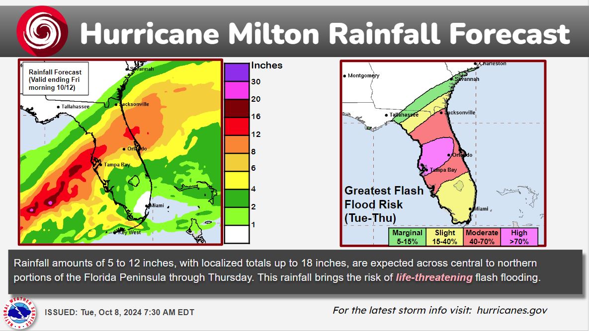
🚨 A High Risk of Excessive Rainfall has been issued for parts of the central/northern FL Peninsula beginning tomorrow (Wednesday). Inland and coastal flooding may combine to increase the overall flood threat and produce the risk of life-threatening flash flooding. #FLwx
Hurricane Milton is a Cat 5 with maximum sustained winds of 180 mph and a minimum pressure of 905 mb. Hurricane-force winds extend outward up to 30 miles (45 km) from the center and tropical-storm-force winds extend outward up to 80 miles (130 km) https://t.co/2XdodadWiE
Hurricane Milton is now a Cat 5 with maximum sustained winds of 160 mph after a period of rapid strengthening. Minimum pressure is down to 925 mb https://t.co/DiZNyBA94E
Latest forecast from the NHC now takes Hurricane Milton to a Cat 5 with 165 mph max sustained winds. Currently, Milton has 155 mph max sustained winds and a 933 mb minimum pressure https://t.co/HPzsrzY8gA
#MILTON UPDATE: There is a lot to say about Hurricane Milton. But here are some key points:
- There is no way to know for sure if the Tampa Bay area will take a direct hit. It's too close to call. It will likely be too close to call up to near landfall.
- If the center jogs just south of the entrance to Tampa Bay, the situation in Hillsborough and Pinellas Counties will be bad, but not catastrophic. If the center comes ashore just north of the Bay, the surge will be significantly worse than Helene. Vast areas around Tampa Bay, including much of Pinellas County and downtown Tampa, will go underwater.
- The Gulf water will be pushed up to 12 feet above normal high tide along the entire densely populated west coast of Florida near and south of where Milton's center comes ashore. Know the forecast for your area and evacuate if ordered.
- Hurricane-force winds will spread across the state on both sides of the storm track. In fact, the strongest winds and highest flood potential will likely be north of the track of the storm. Tornadoes are possible .
Unless we get extremely lucky, Milton will be one of the biggest hurricane disasters in history.
More at https://t.co/PicsKl6xn5