@SteveFrosh60708 Why isn't there a working prototype on display?
Also you lost me on "It Charges itself".
If it does that, why does it only last 18hrs when it could just charge itself forever?
Because many Nigerians have yet to experience a better standard of living, the concept can often feel entirely alien to them. They simply lack the personal understanding to comprehend it.
It's similar to attempting to explain the concept of gravity to a dog; the dog can't relate to that experience or imagine how it works.
Introducing Mini 2, the next-generation portable Starlink. Get up to 4.5 hours of connectivity on a single charge with the quick-swap battery, or plug in with USB-C.
With built-in Wi-Fi, all you need is a clear view of the sky to get online in 60 seconds.
Preorders are now open by invitation in the US. Be the first to know when it's available → https://t.co/t2pSI1buaW
LMaoooooo.
Same moron that abandoned a Mono Rail Project started by his predecessor and asked if it could be converted into a museum at an Architectural Festival event in 2016.
2 Things.
It's either you don't know what you're saying or he doesn't know what he's saying.
Self Charging? Generators..
What's powering it? Air, Water, Sunlight?
Pastor Chris Oyakhilome launches
Noiseless Generators.
Self Charging
No Fuel, No Diesel, No Gas.
Far Cheaper.
Self Charging
This man is better than 18,302 Nigerian politicians put together.
In my guess must be battery inverter hybrids or electromagnetic/kinetic systems.
Their new tactic is to post fake videos.
Then their minions, people like the brain dead @Bond_not_james debunk them whilst knowing very well that it's from fake accounts.
The idea is to make you start doubting his popularity. These guys are just not smart. They don't know we know.
People must begin to understand that economic systems are human arrangements. They are designed, maintained and modified through political choices. What human beings construct, human beings can also change.
The interesting thing here is that the reply visuals from this dude were also created using AI.
The very same thing he just tried to center his criticism on. In fact, I just ran the visuals and it all highlighted all the errors in his visuals.
You people are just not serious.
Again, the centre of your criticism is just "He showed AI images" and "You're an architect." You haven't explained, value for value, why his proposal won't work.
You clearly don't understand what a "concept" is, or that a concept can take any form—a hand sketch, 3D renders, AI-generated images, paper models, etc. You're boldly claiming to work within the engineering space AND you don't know these things? What a miss.
See ehn... you people have made so much noise that only exposes your biases and lack of actual knowledge. Our educational system has truly gone to the dust.
You haven't raised a single tangible counterargument in terms of efficiency or value. Where is your design analysis showing that his proposal won't work or deliver better value? Or are you just countering for the sake of it, out of hate that he went to one of the best design and engineering schools in the world?
All you've said is "You're an architect, you created AI images, architects use Revit, Lagos institutions, blah blah blah..."
You people say a lot without actually saying anything—and honestly, I don't even blame you; I blame our educational system.
To further buttress Mr @Bond_not_james 's earlier explanation on this AI-generated masterplan by Mr GRV, I am highly disappointed that someone running for governor of Lagos could be this lazy with research. He generated these images with an AI tool and posted them as a plan for the state, and people are in the comments saying wow.
I work in GIS and Construction, and a good part of that work has been on Lagos waterways. both coastal and lagoon I have done the Falomo to Epe trip more times than I can count, gone through Ojo Creek and Badagry Creek, and gone all the way to where Epe meets the Ogun State boundary. When I saw this video, I knew arguing in the comments would not be enough. That is why I decided to design these maps, so that anybody, including you sir, can see the difference between the Lagos in your video and the Lagos on the Lagos that truly exist. Follow me one image at a time.
Image 1: This is not Lagos
Let's start from your own picture. You drew one big lake running from Ikorodu to Epe, with Ijede sitting directly across the water from Ibeju-Lekki. Now look at the real lagoon beside it. The open water of the Lagos Lagoon stops about 18 km before you reach Epe. After that, all you have is a channel about 1 km wide. Ibeju is not on the Lagos Lagoon at all. It is 15 km away from it. If you draw a straight line from Ijede to Ibeju, it is 34 km long, and 24 km of that line is dry land. Those fine AI waterfront estates you put on the south shore? That place is forest and swamp. Abijo, Lakowe and Awoyaya are 6.5 to 7.7 km from the lagoon edge. So before we even talk about bridges, the map itself is completely wrong.
Image 2: Your four "short bridges" on real ground
Now let's take your four bridges and place them where they would actually stand. The water spans add up to 17.2 km of bridge. But a bridge has to land somewhere. On the Lekki side, your bridges land 3.8 to 13.7 km away from the Lekki-Epe Expressway, so you need about 58.6 km of new road through swamp and forest just to reach them. Your video did not show one metre of that road all its is showing is AI moving car. Also note that this lagoon is mostly under 2 m deep. Barges cannot reach the site without dredging a channel first, and the piles have to go deep through soft clay and peat. And after spending all that money, every one of the four bridges brings its traffic back to the same Lekki-Epe Expressway that is already choked at Ajah. You have not solved the traffic. You have only moved it.
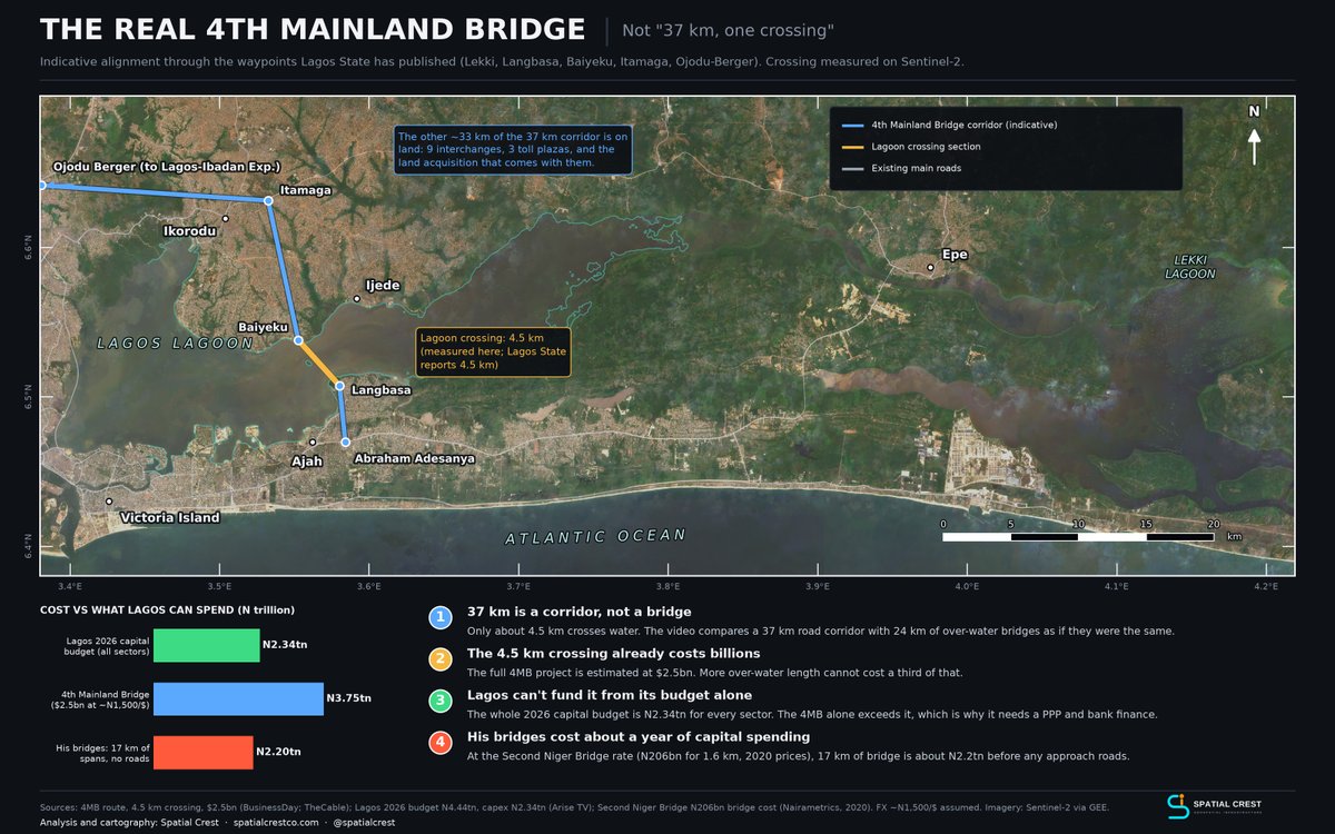
Image 3: The real 4th Mainland Bridge
Your chart says the 4th Mainland Bridge is "37 km, one crossing". Sir, 37 km is the length of the whole corridor. The part that actually crosses the lagoon runs from Langbasa to Baiyeku. I measured it on the map at 4.5 km, the same figure Lagos State has published. That project is estimated at $2.5bn, which is more than the entire 2026 capital budget of ₦2.34tn for every sector in Lagos. That is why it needs PPP and bank financing. Yet you are telling people that four bridges with far more length over water will cost a third of it. Using the Second Niger Bridge rate of ₦206bn for 1.6 km, your 17 km of bridge alone comes to about ₦2.2tn, before one metre of approach road. That is a full year of capital spending for the whole state. So where is the money coming from?
Image 4: What Lagos is already building
The eastern corridor is not an empty space waiting for renders. Look at the green line. The Omu Creek road and bridge is under construction right now. It runs 4.1 km from Sangotedo to the lagoon edge at Ito-Omu, and the bridge is about 600 m, not 6 km. Now follow the light green line from the Itomu jetty. That is an existing road, unpaved, running 30.6 km through Eleranigbe until it comes back onto the Lekki-Epe Expressway at Eleranigbe junction. it connects communities, like isan, Oko-abe, oriba and other communities in epe and ibeju-lekki in that axis, Okada riders and those who has Trucks and SUV use it every day, and I mapped part of it myself. Pave that road and Lagos has a second east-west route beside the expressway, on land the road already occupies. The yellow line is the federal Lekki Deep Seaport to Epe road, which is ongoing and takes port and refinery trucks to Epe. The blue line is the 4th Mainland Bridge, which already has a route, a design and people ready to finance it. Somebody who wants to govern Lagos should be asking how to finish and connect these projects, not throwing them away for a fresh drawing that only exist in ChatGPT.
Image 5: Omi Eko, the lagoon is already a network
Your video treated the lagoon as an obstacle to cover with bridges. Look at the blue lines on this last image. Those are ferry routes. On this stretch alone, about 19 ferry links already run between a dozen jetties, from Ikorodu to Itomu. People from Ikorodu, Baiyeku, Ijede and Ibeshe go straight to Falomo by boat, with no bridge and no Third Mainland traffic. Under Omi Eko @TalktoLaswa , terminals like Badore are being upgraded. Badore alone has five mapped routes, and Badore Road takes you from the terminal to the expressway. Now see how everything connects. Omu Creek Road ends at the Itomu jetty. Badore Road ends at Badore terminal. The 4th Mainland Bridge lands at Langbasa and Baiyeku, which are both ferry points already. You can decide to drvie all the way or come down from a bus and you enter a boat. That is what intermodal transport means for Lagos. Building roads does not mean we should stop using the water.
Now let me ask you something. Do you know what the Land Use Act says, and what it actually takes to acquire land in Lagos, even for public use? Every one of those bridge landings sits on somebody's ancestral land. You will be sitting with families, omo onile, baales, obas and community heads, negotiating compensation and resettlement. That is before you get to the EIA, and before you face the fishermen whose livelihood is on that water. Those conversations happen in Yoruba, inside those communities, with people who know every inch of their land. For someone who has downplayed the importance of learning Yoruba, how do you plan to sit at those tables? It is obvious you have not spent much time beyond the Island.
None of this shows up in an AI image. Revit, Lumion and AI can make anything look convincing, but a fine render is not knowledge of the ground, and it does not make a project feasible or fundable. Being an architect does not automatically mean you understand governance either. Lagos is run through institutions, budgets, land administration, communities and projects that have to continue from one government to the next.
You are proposing to govern an entire state. First, understand the state beyond the images you can generate of it.
There's nothing wrong with him supporting APC. In fact, he had mentioned he had a bias for APC in one of his videos. It's his choice (Lol. He doesn't really have a choice).
He should stop trying to hide his bias. It's very glaring. We all can see it and don't really care that much. My concern is the things he meddles into with very limited knowledge and wants to portray himself as a "thought leader".
@0xjaykae_ I don't believe it'll be cheaper in overall construction and development cost.
But cheaper in VALUE when completed against the 4MB? Yes. I can attest to that.
Good idea.
There are still a few bottlenecks to overcome, but that's nothing further design analysis cannot solve, which I don't think a simple tweet will cover.
In today's world where alternatives can easily be modeled and simulated to pick the best ranking based on multiple competing goals, I want to believe that must've been or should be explored if it weren't already - We can do this @blazeinchq
That said, my first level analysis is that this would be slightly more expensive but quicker to achieve in phases and sections easing up congestion as each phase is commissioned against the 4th Mainland bridge that can't be used until it is fully completed and commissioned.
Overall, the entire scheme definitely will be a lot more efficient by design compared to the 4th Mainland bridge only proposal.
GRV DEBATES- ISSUE: 2/5
Connecting Ikorodu and the entire Lagos East:
The benefit of having interlinked belt roads to connect Lagos East far out weighs a 4th-mainland bridge.
1) It is cheaper to achieve.
2) It opens up the entire axis for development
3) It improves the interconnectivity of the eastern foreshore by giving people more options for movement .
#Ourlagos
@0xjaykae_@GRVlagos As it stands today, the newer scheme proposal by GRV is going to deliver more value per $ or ₦ spent than the 4MB.
That's why although initially there was a masterplan, the revision is necessary.
Master plans are guidelines, not rigid mandates. They are usually revised over time (e.g., every 10-15 years for a city like Lagos, depending on factors like population growth, demographics, and needs).
It's limiting thinking to assume a master plan will remain fixed permanently. Especially for plans older than 20 years, there's a need for updates to reflect the evolving landscape and consider evolving factors – within the context of what's reasonable given the time and circumstances.
A quick analysis of both already shows GRV's idea is a better scheme, albeit more expensive because of the extra routes and elements involved.
For long term, GRV's idea is more modern, efficient and will accommodate Lagos' possible population explosion as projected by 2050 but like I said, will definitely be more expensive and I said that here.
Not someone showing an unscaled map that he can't even read and thinks maps or future plans tell all the answers and should not be reviewed or revised.
https://t.co/6neJxFL6Z1
Good idea.
There are still a few bottlenecks to overcome, but that's nothing further design analysis cannot solve, which I don't think a simple tweet will cover.
In today's world where alternatives can easily be modeled and simulated to pick the best ranking based on multiple competing goals, I want to believe that must've been or should be explored if it weren't already - We can do this @blazeinchq
That said, my first level analysis is that this would be slightly more expensive but quicker to achieve in phases and sections easing up congestion as each phase is commissioned against the 4th Mainland bridge that can't be used until it is fully completed and commissioned.
Overall, the entire scheme definitely will be a lot more efficient by design compared to the 4th Mainland bridge only proposal.
I've said this and I'll say it again - This dude is slow and how you guys listen to him baffles me.
His argument is "Oh there's a solution already, but it's not been implemented". Such a lazy ass way of approaching problems that are as dynamic as a city evolves.
Cities evolve with time and solutions are not exhaustive. I was expecting him to counter the scheme with why GRV's solution is either more expensive, won't solve the problem better or will achieve less goal than the proposed 4MB. No instead his rebuttal is that Lagos Civil Service has all the solutions already .. Such a limiting way of thinking and he claims to be a Mechanical Engineering Graduate. No wonder ....... (No, I won't digress)
I've always said Nigerians know how to platform noisemakers and this is a typical example of it. I won't also blame Nigerians because these noisemakers don't stop talking once you give them a mic.
100K impossible? Not true.
It's understandable when people don't see alternatives. There have been research on CLT and Modular Housing and the speed these Construction Methodologies bring to Construction.
For housing, aside from political will, the next problem is methodology and that already has a solution.