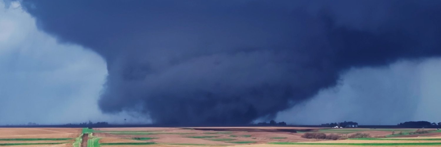
A tornado warning has been issued for Fremont county in Southwest Iowa until 3PM. At 237 PM CDT, a severe thunderstorm capable of producing a tornado was located 6 miles northeast of Julian, or 6 miles southeast of Nebraska City, moving northeast at 20 mph
Heavy rain-producing thunderstorms are expected to develop and increase in coverage across parts of Nebraska, Kansas, Missouri, and western to central Iowa through this evening.
Some of these storms may move over the same areas repeatedly, leading to very heavy rainfall. Rainfall rates of 1 to 2 inches per hour will be possible, and a few locations could see 3 to 4+ inches of rain before sunset.
Because many areas can only handle around 2 inches of rain in a few hours before flooding begins, flash flooding is becoming increasingly likely in some locations. Low-lying areas, small streams, creeks, and roads that commonly flood could be impacted.
If you live in western or central Iowa, keep an eye on the weather this afternoon and evening. Never drive through flooded roadways, and be prepared to move to higher ground if flooding develops in your area.
We'll continue to monitor the situation and provide updates as conditions evolve.
#iawx #iowaweather #flood
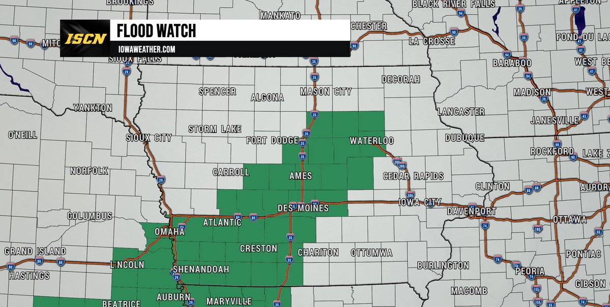
The National Weather Service has expanded the flood watch further to the northeast for this afternoon into Friday morning. 2 to 4 inches with locally higher amounts of rainfall will be possible within this watch area. #iawx#iowa#flood
The latest in regards to the flood threat and severe weather threat has been posted on our website. Click the link to read more.
https://t.co/PBUvc9CPne
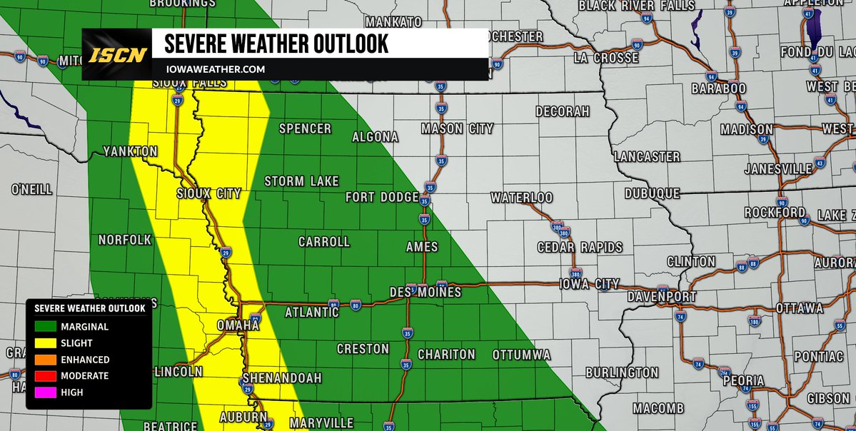
Strong to severe thunderstorms are possible across parts of Iowa later this afternoon and tonight.
The greatest risk appears to be across western, central, and southern Iowa, where a few storms could become severe as they move through the state.
Main threats include: large hail, damaging wind gusts, and isolated tornado, and heavy rainfall with localized flash flooding.
While not everyone will see severe weather, any storm that develops this afternoon and evening will need to be monitored closely.
We'll be tracking conditions throughout the day and will provide updates as new information becomes available.
Make sure you have the ISCN Weather app installed and notifications enabled so you can receive watches and warnings as they're issued.
#iawx #iowaweather #severeweather
A Flood Watch is in effect this afternoon through Friday morning for much of southwest and central Iowa, including the Des Moines metro.
Repeated rounds of thunderstorms may produce 2-4" of rain, with isolated higher amounts possible. Flash flooding could develop, especially in low-lying and flood-prone areas.
Never drive through flooded roads. Turn Around, Don't Drown.
📱 Stay weather aware with the ISCN Weather app and follow us for updates throughout the day.
#iawx #iowaweather #flood
Confidence is increasing that some thunderstorms could become severe Friday afternoon and evening across parts of Iowa.
The SPC has expanded the Slight Risk area slightly farther east. Large hail and damaging winds remain the primary threats, but a few tornadoes may also be possible if storms remain isolated Friday evening.
Morning storms and cloud cover will play a key role in how the threat evolves. We'll continue to refine the forecast over the next 24-36 hours.
📱 Stay weather-aware with the ISCN Weather app and check back for updates. #IAwx
Strong to severe thunderstorms may develop during Friday afternoon and evening across northwest #Iowa, bringing the potential for large hail and damaging wind gusts. Forecast details will continue to be refined over the next couple of days. #iawx
https://t.co/laMrIQJUM1
The Weather Prediction Center (WPC) has highlighted a large portion in #Iowa in a risk of heavy rainfall as widespread rain looks to be likely. #iawx
https://t.co/GWgTX5WN7I
A thunderstorm moved through Jefferson, Iowa around 5PM Monday evening. Strong winds caused multiple tree limbs to snap as well as some other wind related damage.
Thank you to Jen Savits Badger for sharing this video with us.
A Severe Thunderstorm Watch is in effect for northwest Iowa until 1:00 AM CDT. Thunderstorms developing this evening may produce large hail up to 1.5 inches in diameter, damaging wind gusts up to 70 mph, and an isolated tornado or two. The tornado threat appears greatest with any storms that develop near a boundary across the region during the evening hours.
A separate Severe Thunderstorm Watch is in effect for portions of west-central and southwest Iowa until 3:00 AM CDT. Additional thunderstorms may develop later this evening and continue overnight, with large hail being the primary threat. Some storms could produce hail up to 2 inches in diameter along with damaging wind gusts up to 70 mph.
If you are located within either watch area, be sure you have multiple ways to receive warnings overnight, including the ISCN Weather app. We'll continue to monitor conditions and provide updates as needed.
#iawx #iowaweather #iowa #severeweather
The Storm Prediction Center indicates a localized corridor of enhanced tornado potential may persist for another 1 to 2 hours across portions of southeast South Dakota, northeast Nebraska, and northwest Iowa.
Storms near Sioux Falls continue to show signs of rotation, and conditions remain favorable for tornado development. The greatest concern will be with storms on the southern flank of the storm cluster as they move east-southeast this evening.
If you are in northwest Iowa, especially near the South Dakota and Nebraska borders, remain weather-aware and be prepared to take shelter quickly if a warning is issued.
The Storm Prediction Center has added a Slight Risk (Level 2 of 5) for severe weather this evening to include areas right along the Iowa/Nebraska border.
A few thunderstorms may develop near the Missouri River during the evening hours as a weak disturbance moves through the region. If storms are able to form, they could quickly become severe with the potential for damaging wind gusts, large hail, and an isolated tornado cannot be ruled out.
Storms are also developing farther north near southeastern South Dakota and may continue to pose a risk for large hail, damaging winds, and a brief tornado as they move southeast.
While widespread severe weather is not expected across Iowa tonight, residents in western Iowa—especially near the Nebraska border—should remain weather aware through the evening and overnight hours.
Be sure to have the ISCN Weather app installed and keep an eye on updates as we continue to monitor storm development.
#iawx #sdwx #newx #severeweather #weatherupdate
The severe weather threat for Iowa on Sunday has been lowered, with the SPC removing the Slight Risk and leaving a Marginal Risk across parts of western and southern Iowa.
A few storms could still produce large hail, damaging winds, and heavy rain if they develop.
Full forecast: https://t.co/SvN5VkzeJE
#iawx #iowaweather #weatherforecast #iowa
Rain chances will continue across Iowa through the weekend, with the highest rainfall totals expected across the western half of the state.
Scattered showers and thunderstorms will be possible overnight tonight, with additional rounds of rain expected on Saturday and Sunday before conditions gradually dry out by Monday morning.
According to the latest rainfall forecast from the Weather Prediction Center, areas west of Interstate 35 can expect widespread rainfall totals of 0.5" to 1", with some locations in western Iowa potentially exceeding 1". Farther east, rainfall amounts will generally be lighter, with most areas seeing between 0.1" and 0.25".
If you have outdoor plans this weekend, be prepared for occasional periods of rain and keep an eye on the forecast for updates.
Download the ISCN Weather app and check back throughout the weekend for the latest forecast updates and radar trends.
#iawx #iowaweather #rainfall #iowa
Scattered showers and thunderstorms will bring periodic rain chances to parts of the state this weekend, though it won't be a washout. We'll also be watching for a few isolated strong storms Sunday afternoon and evening in western Iowa.
Read our latest forecast: https://t.co/wcNdKRpM05
#iawx #iowaweather #weatherforecast
A few strong to severe thunderstorms may develop across western Iowa late Sunday afternoon and Sunday evening.
The Storm Prediction Center has placed parts of the area under a Marginal Risk (Level 1 of 5) for severe weather. Any storm that develops could produce hail and damaging wind gusts, though storm coverage is expected to remain isolated.
Stay weather aware and check back for updates. #iawx
Iowa's first prolonged stretch of summer-like heat may be on the horizon.
The Climate Prediction Center has the northern half of Iowa under a Moderate Risk of Extreme Heat for June 6-8, with drought concerns also developing in parts of eastern and northeastern #Iowa.
Read more: https://t.co/Js4rIojBTB