Advocates for West Virginia’s manufacturing industry are educating companies to look at their fellow manufacturers for the supplies they need instead of relying on foreign imports.
https://t.co/gOzXpNxEFV
VOTE NOW for your favorite product for the Coolest Thing Made in West Virginia Contest!
The WVMA recently launched the inauguralCoolest Thing Made in West Virginia contest to celebrate the innovative, world-class items manufactured right here in the Mountain State….
Per Bloomberg report...
Anthropic PBC has agreed to spend $45 billion to rent AI cloud computing power from Nscale’s flagship data center development in West Virginia.
Nscale will use Nvidia Corp.’s Vera Rubin chips to meet Anthropic’s needs, with the commitment over six years and representing about 460 megawatts of power.
The deal is for the first of three buildings at Nscale’s Monarch campus in West Virginia, which will total about 1.35 gigawatts when complete.
Dolly...
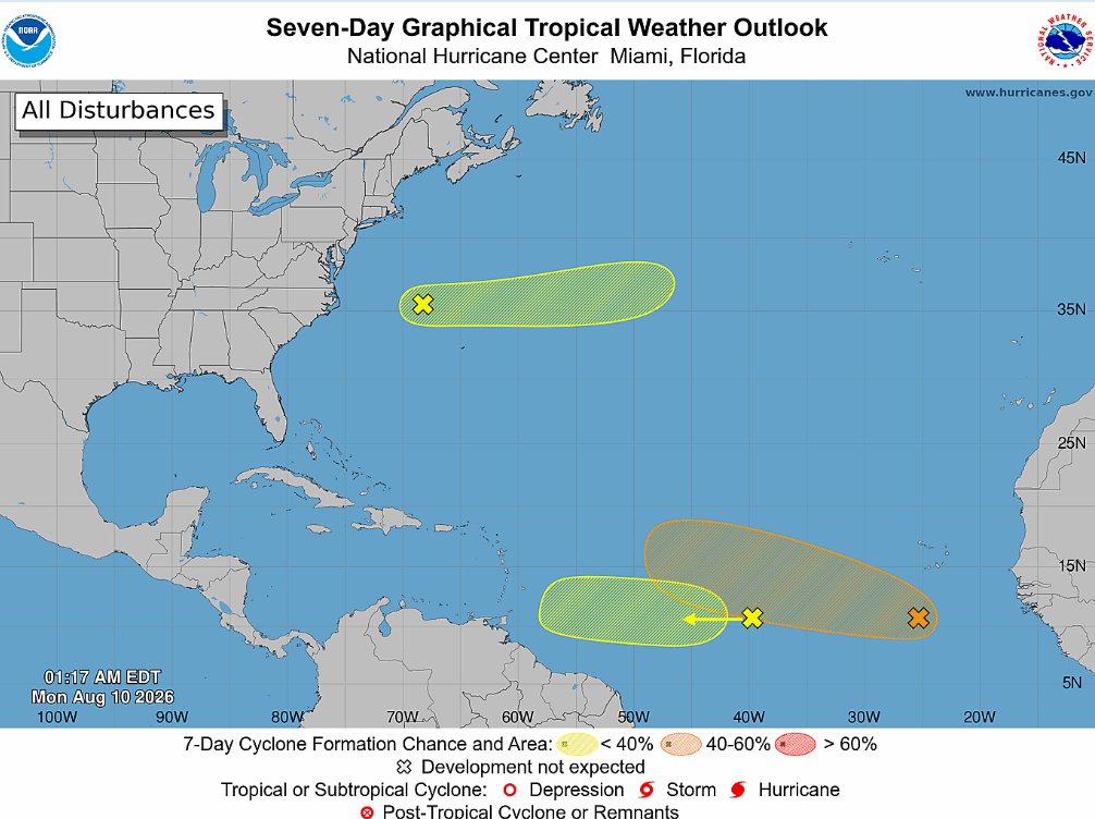
Quite the coincidence given yesterday's sad events, but the next named system in the Atlantic Basin will be Dolly.
An area of low-pressure southwest of the Cape Verde Islands will have a chance of that... a 60% chance of forming into a Tropical Cyclone.
Flash Flooding Potential 🌧️
Thankfully, it doesn't look to be as widespread as last week, but any heavy shower/storm has the potential of causing flash flooding in *spots* due to how saturated the ground is.
For Today, a marginal risk (1/4) exists - implying that isolated flash flooding is possible, mainly this afternoon and early-evening when scattered showers & storms pop up.
For Friday, a scattered shower or storm is possible in the lowlands - but downpours and storms will be more focused across the higher elevations of southern and eastern WV. Pockets of 3"+ will be possible in that area, so keep an eye out.
Meanwhile in the Atlantic, several areas of interest have popped up recently with the most interesting one being the system south of the Cabo Verde Islands. This is the one guidance develops and turns north around a potential weakness in the Atlantic subtropical ridge. Some guidance keeps it week and moving west. There is still plenty of time to watch these areas and the lead system could bring well needed rain to the islands this weekend.
⛈️⚠️ Risk for flash flooding and severe storms will be elevated this upcoming week…
Meanwhile, A LOT of smoke will be moving across the U.S. from wildfires in the Pacific Northwest. Most of this smoke will remain aloft, but there will also be times when it may drop closer to the ground and reduce air quality some.
Smoke can sometimes complicate thunderstorm forecasts and be sort of a wildcard. On one hand, it can reduce instability a bit — but smoke particles can also help enhance rainfall and lightning.
Either way, this week looks to be an active and interesting one. Have a way to get warnings, and stay tuned to the latest forecasts.
Good Thursday!
This is more like it 🙂
50s and low 60s across our region thanks to a BIG drop in humidity behind the front.
It's also clear and dry... just seeing a little valley fog form in spots before the sun rises.
Tuesday ⛈️
The Storm Prediction Center has placed our region in a 3/5 Level for Severe Storms.
In this type of environment, storms will be capable of:
⚫️ Damaging Straight-Line Winds
⚫️ Isolated Tornadoes
⚫️ Flash Flooding
The risk for severe weather will especially be elevated if more daytime heating/sunshine occurs.
At this point, it's the broad environmental ingredients that catch your attention - but the ceiling of these storms will ultimately be decided by the smaller 'mesoscale details'. These can be better seen around 48 hours and in.
The good news? After this strong front, we'll see a nice drop in temps and humidity for the rest of the week.
Just announced! We’ve added a free Introduction to CNC Machining camp in Huntington. Classes run 8:30 a.m. to 4:30 p.m. daily July 13-17. Don’t miss this no-cost opportunity to learn valuable manufacturing skills. More information and registration at https://t.co/47IIUofvBP.