Geolocation| Small UAV, likely operated by Israeli forces, flying above Palestinians walking in the street, next to the heavily damaged Yemen Al-Saeed Hospital, Jabalia Camp, North #Gaza
31.536143, 34.496016
🗓️15 Sep. 2026
@GeoConfirmed
What appears to be a Elbit Hermes 900 UAV flying over the Tel Al-Hawa neighborhood of Gaza City, as captured on 3 April 2024 Google Earth imagery.
31.503870, 34.438534
@GeoConfirmed
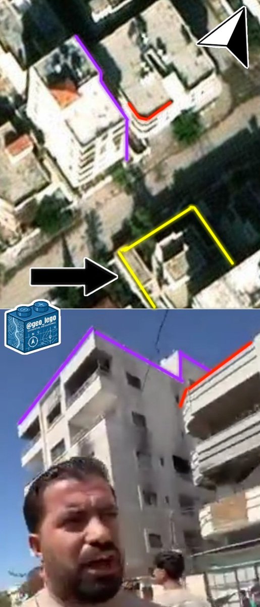
Geolocation of an Israeli Strike on a reported Qassam [Hamas] Weapons production site.
Location: 31.431650, 34.381523
8G3PC9JJ+MJ Al Zawayda, Deir Al Balah Governorate, Gaza Strip.
@GeoConfirmed
A new video shows the destruction of the Azadi Sports Hall, a 12,000-seat sports arena in west Tehran, nearly six months after it was bombed in the early days of the US/Israel war with Iran.
Location: 35.722083, 51.269058
@GeoConfirmed
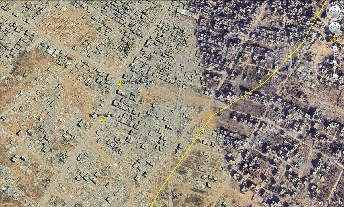
In the night of 21-22 July, Israeli forces seemingly placed another yellow block at Salah Al-Din Street, south of the Dawla roundabout in the Al-Zeytoun neighborhood of Gaza City, Northern #Gaza
31.490505, 34.452431
370m west of the official yellow line.
https://t.co/sLWaC0zPxT
GeoConfirmed announcement.
Following the ill-advised decision to discontinue support for the Google Earth desktop application and to redirect users to the less functional online version, we are witnessing yet another misstep by Google with far-reaching consequences.
The fight against engagement farmers, disinformation campaigns, and adversarial actors seeking to influence public discourse is already an immense challenge. Satellite imagery has long served as a critical benchmark in countering disinformation and verifying claims, and Google Earth was one of the most important tools in this effort.
It is with great concern that we are already observing individuals exploiting the new Google Earth web tool to make military positions, relabel buildings as schools,... and experiment with manipulating the information environment. In effect, users can now fabricate or alter satellite-derived visuals to support false narratives.
The primary, and perhaps only, practical use of this tool appears to be the creation and dissemination of mis- and disinformation. Users can fabricate scenes or objects that do not exist, or alter real locations to depict false realities, and then distribute these manipulated visuals online as if they were authentic.
Fact-checkers may soon find themselves verifying Google satellite imagery using...Google satellite imagery, rather than fact-checking the original claims.
As some experienced geolocators have noted: “We just realized that geolocators are going to have to waste time geolocating fake Google Earth images now to debunk disinformation. This is fucking chaos.”
We urge @Google to reconsider this decision.
@googleearth should aid the global effort against dis- and misinformation, not inadvertently enable it.
Do not become like X.
Newly published CCTV footage shows the moment the Shajareh Tayebeh primary school and a nearby IRGC compound in Minab, Iran, were targeted by Tomahawk missiles on 28 February, killing 120 children.
CCTV: 27.101690, 57.080159
Minab school: 27.109804, 57.084732
@GeoConfirmed
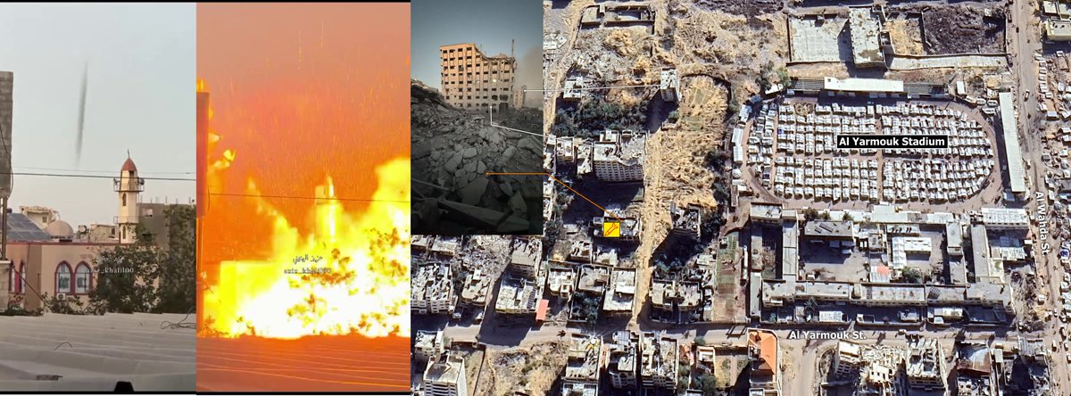
Geolocation #368: Dar Al Al-Muttaqin Mosque Bombed and Destroyed in Gaza City
غارة اسرائيلية تدمر مسجد دار المتقين بجانب ملعب/مخيم اليرموك في مدينة غزة
🗓️July 28, 2026
Next to Al Yarmouk Stadium/IDP, Al Daraj quarter, Gaza city, Palestine
📍31.516650, 34.456481
Columns of smoke rise from a naval base and university owned by Iran's Islamic Revolutionary Guard Corps (IRGC) in the northern town of Zibakenar on the shores of the Caspian Sea following US strikes.
Location: 37.441677, 49.864212
@GeoConfirmed
Israeli one-way attack drone/missile remnants displayed by Civil Defence spokesperson Mahmoud Basal after a strike that killed Firas Ahmed al-Masri, his wife, and four children in Gaza City.
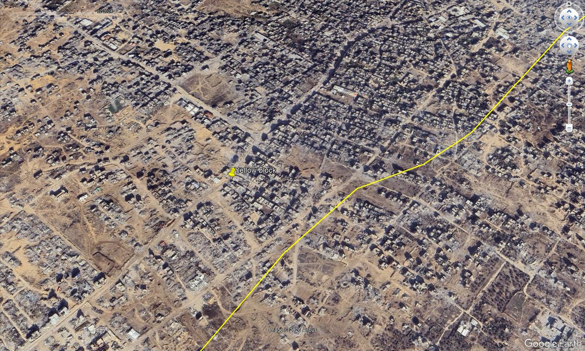
Geolocation| Yellow block and vehicle tracks on Salah Al-Din Street, south of the Dawla Junction in the Zeytoun neighborhood, Gaza City, Northern #Gaza
31.489306, 34.451556
🗓️16 July 2026
More than 300 meters NW of the official yellow line.
@GeoConfirmed
https://t.co/NADxU92AEl
Geolocation #364: Airstrike on an Apartment in Gaza City Kills a Family of Five, Including 3 Children
غارة على شقة في حي الرمال بمدينة غزة تقتل أسرة من 5 أفراد بينهم 3 أطفال
🗓️July 18, 2026
Lababidi roundabout, Al Rimal Quarter, Gaza city, Palestine
📍31.529036, 34.452669
Geolocation #363: Strike on Funeral Kills 9 Palestinians in Al Nuseirat
استهداف جنازة في النصيرات يقتل 9 فلسطينيين
🗓️July 17, 2026
Al Nuseirat, Central Gaza, Palestine
📍31.447181, 34.385747
🧵Geolocations of 2 yellow blocks, likely placed by the Israeli military, roughly 330 & 380 meters northwest of the formal yellow line in the Shuja'iyya neighborhood, Gaza City, Northern #Gaza
This is SW from 2 other blocks placed in mid June 2026.
https://t.co/Q3qyyrzdoA
Geolocation| Human remains in the street after an Israeli strike in the Abu Sita area, near the Jordanian Field Hospital, Khan Younis, South #Gaza
2 people were reportedly killed.
31.343085, 34.294824
🗓️9 July 2026
https://t.co/IveiySrASn
Geolocation| Destroyed car after a reported Israeli strike at Haider Abdel Shafi junction, Charles de Gaulle Street, Al-Rimal neighborhood, Gaza City, Northern #Gaza
31.522290, 34.439353
🗓️9 July 2026
Photo: https://t.co/ybtNPhadAo
@GeoConfirmed
https://t.co/m0FS34m7gU
Geolocation| Israeli forces driving amid destruction NW on Salah Al-Din Street, northwestern Rafah, South #Gaza
31.275176, 34.301709
Reportedly posted on 29 June 2026
@GeoConfirmed
https://t.co/WC8PqOofEB





![Stinky915846091's tweet photo. Geolocation of an Israeli Strike on a reported Qassam [Hamas] Weapons production site.
Location: 31.431650, 34.381523
8G3PC9JJ+MJ Al Zawayda, Deir Al Balah Governorate, Gaza Strip.
@GeoConfirmed https://t.co/d1qjtRbcn8](https://pbs.twimg.com/media/HQaqFH9WQAAV7XK.jpg)