I've been putting in the work in crypto for a while now, and it's been paying off. To celebrate, I just copped myself a brand-new car! Huge shoutout to @CC_Rachel_eth, my coach, for all the guidance and support. Couldn't have done it without her.
3:45 AM Fri 6/19 - SEVERE STORM SW of Hobart is slowly increasing. Could now produce quarter size hail and winds to 60 mph. This storm is crawling slowly drifting NE at 15 mph. #okwx
2:20 AM Fri 6/19 - Tracking strong storms in western & SW OK this morning. Moving NE at 15 mph. Lots of lightning right now with winds to 40 mph and possibly some pea size hail. Not severe at this time. #okwx
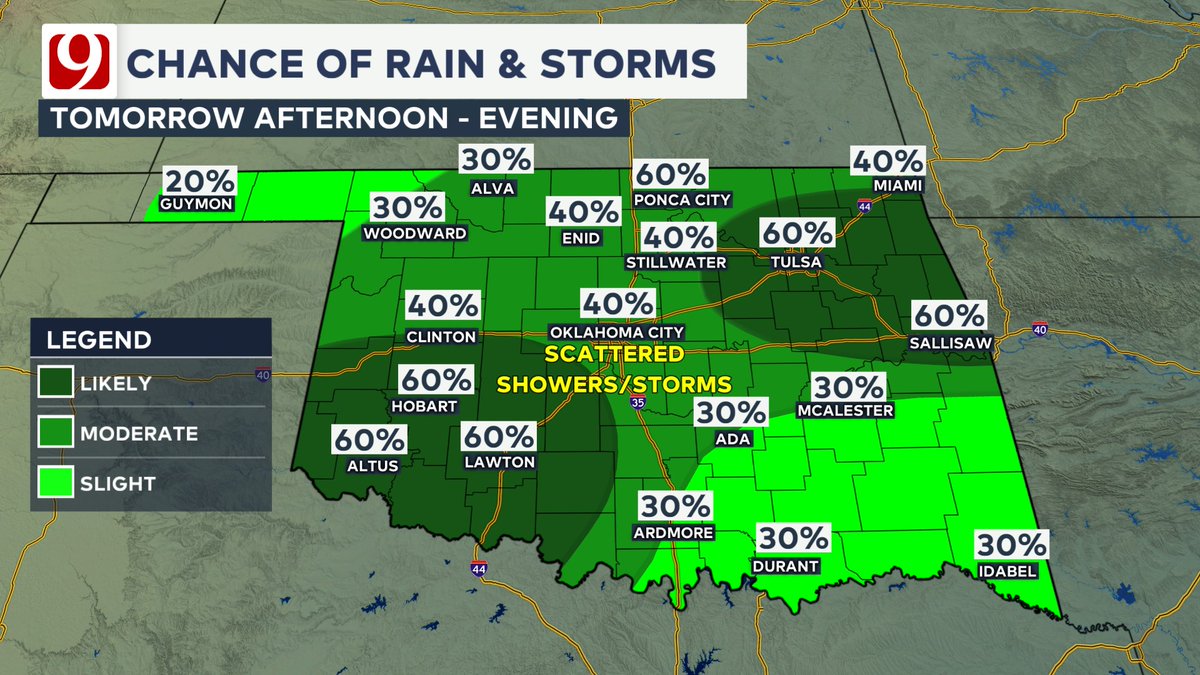
Tomorrow afternoon looks drier as rain exits eastern Oklahoma. Temperatures will still be warm, but the summer heat holds off. Temperatures will continue to climb into Father's Day on Sunday while we await our next wave of rain and storms. #okwx
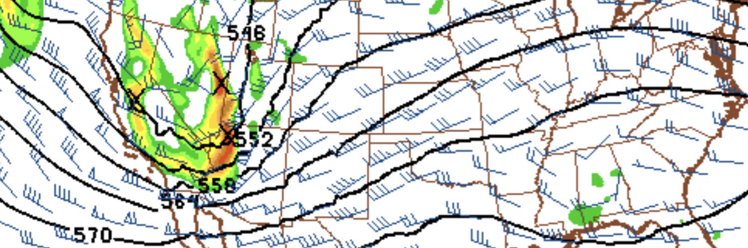
Rain and storm chances stay mainly in the north and northwest this evening, but they'll shift south overnight. We're watching for a cluster of rain and storms to develop in western and southwestern Oklahoma which will move east through the morning hours tomorrow. #okwx
Radar Update 12:18 PM - Strong thunderstorms continue in northern Oklahoma and Kansas producing heavy rain and lightning. These will remain mainly in northern/northeastern Oklahoma through the afternoon hours with better rain chances in central/southern Oklahoma tonight. #okwx
10:05 AM Update- Tracking scattered showers & storms across north central Oklahoma. A severe storm was SE of Lamont moving towards Tonkawa & Marland at 20 mph. This storm is capable of 1.5" size hail & winds to 60 mph along with very heavy rainfall. Watch out for flooding. #okwx
A hot evening with a south wind & temps only falling into the 80s. Overnight, our cold front starts to drift south out of Kansas with a chance of storms. Most will stay dry in the 70s. Tomorrow, north winds & clouds along with rain chances divide the state from 70s to 90s. #okwx
7:47 PM LARGE HAIL EVENT UPDATE: Baseball size hail has moved thru far west/SW Harper county and is moving into north Ellis county. Larger than baseball size hail possible with this storm. Approaching Gage at 8:19 pm. Picture is of Kyles truck and what baseball size hail can do!
7:53 PM SEVERE UPDATE: Kyle Wilson has been under the most intense core of the storm and it has produced baseball size hail west of Laverne. His truck has taken damage from the large hail. Storm is moving SSE at 25 mph.
7:01 PM SEVERE UPDATE: The storm passing thru Rosston has golf ball size hail confirmed by Storm Tracker Kyle Wilson. Moving SE at 24 mph. The storm is moving into Laverne with damaging hail.
HEAT KICKS IN WEDNESDAY: Heat alerts are posted for parts of central and west OK for heat index climbing to 100 to 110 degrees during the afternoon and evening. Heat stress is expected if you are out working in the heat.
HEAT RETURNING WITH A FEW STORMS: Warm tonight with a few showers or storms north. Highs will heat up to near or above 90 on Tuesday. A few storms are possible north tomorrow morning.
Crypto’s been a game changer. Never thought I’d be walkin’ through the doors of my own home this soon 🏡. This isn’t just a win, it’s proof that faith + grind pays off. Forever thankful to my coach @CC_Rachel_eth for her wisdom, patience, and pushin’ me past my limits
Temperatures are on the climb this week! We'll still be cooler than normal Monday afternoon with highs in the upper 70s and low 80s, but 90s and 100s are back on tap Wednesday. Keeping an eye on a low chance for storms, mainly in northern Oklahoma, late Tuesday. #okwx
SUNDAY MILDER, LOADS OF HEAT WEDNESDAY! After some great rain for much of the metro overnight, We will see a cooler day today with clouds, limited rain showers and highs in the 70s. The heat will build back in by Wednesday.
FLASH FLOOD WARNING FOR PARTS OF THE OKC METRO THRU 6 AM: Over 3 inches of rain has fallen this morning. High water can be expected across much of the OKC Metro where a flash flood warning is in effect thru 6 am. Avoid high water that is covering the roadways.