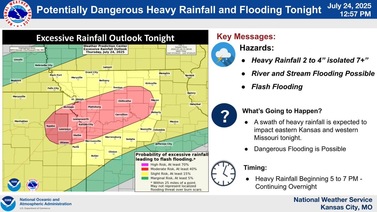
Conditions are shaping up for a potentially dangerous heavy rainfall and flooding event tonight. Rainfall will develop across E. KS into W. MO through 5-7 PM and continue overnight. The greatest rainfall could impact the KC Metro and surrounding areas. #mowx#kswx#KC
Thunderstorms are expected to return to the region tonight. Some of the storms may be capable of large hail, damaging winds and locally heavy rainfall.
The next 36 to 48 hours is going to be wild around the KC area. Severe weather is possible tomorrow morning and again tomorrow afternoon. Tomorrow night rain will transition to snow as temperatures plummet on NW winds 40-70 mph with 1-3" of snow possible.
#TheKitchenSink
While we are looking at a brief thaw today & Friday, much cooler conditions return this weekend. If you have to spend significant time outdoors, be sure to dress for the conditions as this will be the coldest air of the season. Wind chills could approach -15 F Mon and Tues.
A major winter storm is expected across NE KS and N MO starting this afternoon into early MON AM. A wintry mix could start as early as this afternoon and transition to snow Sunday afternoon. Wind gusts around 35-40 mph on Sunday could yield possible blizzard conditions.
A winter storm is expected to bring ice, sleet, and heavy accumulating snow starting SAT afternoon. Ice and sleet will be possible for areas south of HWY-50 SAT afternoon into SUN AM. The ice and sleet are anticipated to transition to snow SUN afternoon. Please be safe!
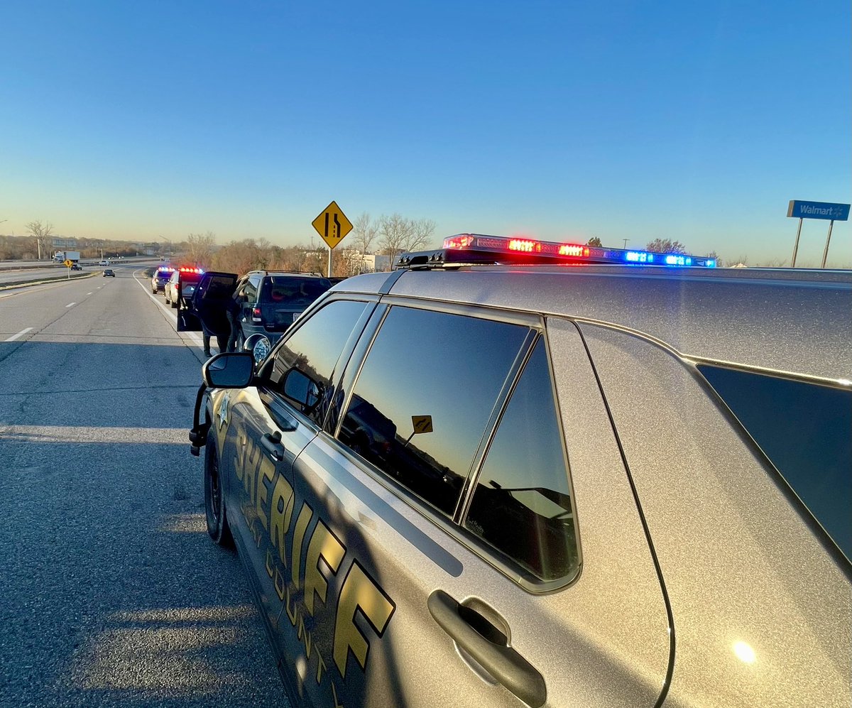
They thought they were cruising, but our deputies hit the brakes on their joyride. This morning we located a stolen vehicle and arrested 2 people at 152 Hwy & I-35. #ThievesAreGrinchesToo
And we go final from Blue Spring South: Liberty Blue Jays 28 - Jaguars 7. The Blue Jays are your DISTRICT CHAMPIONS!!! Next up: State Quarterfinals!! Go Jays. @810varsity @metrosports_mk @myCTsports@PrepsKC@LIBERTYSCHOOLS
Jays punch in another TD on Colt Nolan’s 5yd TD run! PAT good. 5:27 to play in the game: Jays 28 - Jaguars 7. @810varsity @metrosports_mk @myCTsports@PrepsKC
Blue Jays take care of business tonight defeating Park Hill South 42-7. Next up is a trip to St. Joe to take on the Indians of Central HS. @810varsity @metrosports_mk @PrepsKC@myCTsports
It's official! The expansion to @LibertyMissouri Fire Station 3 is open and now in use. Fire Chief John Mills shared that the expansion will better serve the northern portion of Liberty.
Final here from Hyvee Field. The Eagles fall short to the Jays 7-12.
The Eagles are now 1-1 on the season, and back in action next Friday at home against Lee’s Summit West.
@LNEaglePride@LNEagleNews
We're investigating an apparent drive-by shooting that resulted in the death of a teenager in Avondale about 9 p.m. tonight. This is the suspect vehicle. Contact @KCCrimeStop @ 816-474-TIPS with any info. that could help us solve this. More: https://t.co/U9sq7dbtRR
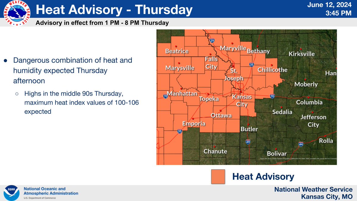
Hot & humid conditions expected tomorrow, with highs in the mid-90s and heat index values in the 100-106 range. These conditions will fuel thunderstorms late tomorrow afternoon into the overnight hours. Some of those storms could be severe, with large hail and damaging winds.
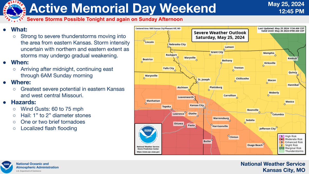
Potential for strong to severe tstorms moving into the area from eastern KS after midnight tonight. Storms are expected to move eastward through SUN AM. Threats include strong winds, large hail, one or two tornadoes, and localized flash flooding.
Severe storms are expected over the Memorial Day weekend for portions of the central U.S. Very large hail, hurricane-force gusts, and strong tornadoes are all possible. Have a severe weather safety plan ready and stay tuned for updates at https://t.co/cM2G0CEJa7.
Widespread severe storms (some significant) are possible Saturday across the central/southern Plains to the Ozarks, and on Sunday from the Ozarks to the lower Mid-MS and Lower OH/TN Valley. Remain aware of approaching thunderstorms, especially if outdoors Memorial Day weekend.