Let’s have a serious conversation about this weekend. We suggest you read through this discussion in its entirety.
Key points:
•Heavy snow at times
•Winds are a concern gusting up to 45-50mph
•Blizzard conditions likely
•Power outages possible
•Major drifting of snow likely, especially in rural areas
•Lake effect snow likely on Saturday and Sunday. Additional accumulations likely for LES prone areas.
DISCUSSION:
First and foremost, we are looking at one of the most potent systems we’ve seen in quite some time. This system is on shore in the US, and data is sampled, our confidence is growing.
TIMING: We expect this system to move into our area Friday morning and by noon Friday, first snowflakes should be falling in the state. Snow will quickly overspread the state as the day goes on turning into a more heavier accumulating snow. As the day goes into the evening, winds begin to pick up statewide.
This system will move off into Canada by Saturday morning with snow still lingering on the backside. At this point, winds will shift to the NW-SE and this will kick up additional lake effect snow for areas prone to lake effect (West Michigan, UP) winds will still be quite strong on Saturday.
IMPACTS:
Sustained winds between 25-35mph seem likely with gusts up to 50mph not out of the question. This will occur as the heaviest of the snow is falling, causing blizzard like conditions, whiteouts, and zero visibility situations for a large area of lower Michigan. This snow will be a little “drier” allowing it to blow more easily. Along with blizzard like conditions, these winds could cause power outages, along with high probability of major drifting of roadways, especially in rural areas where less traffic occurs.
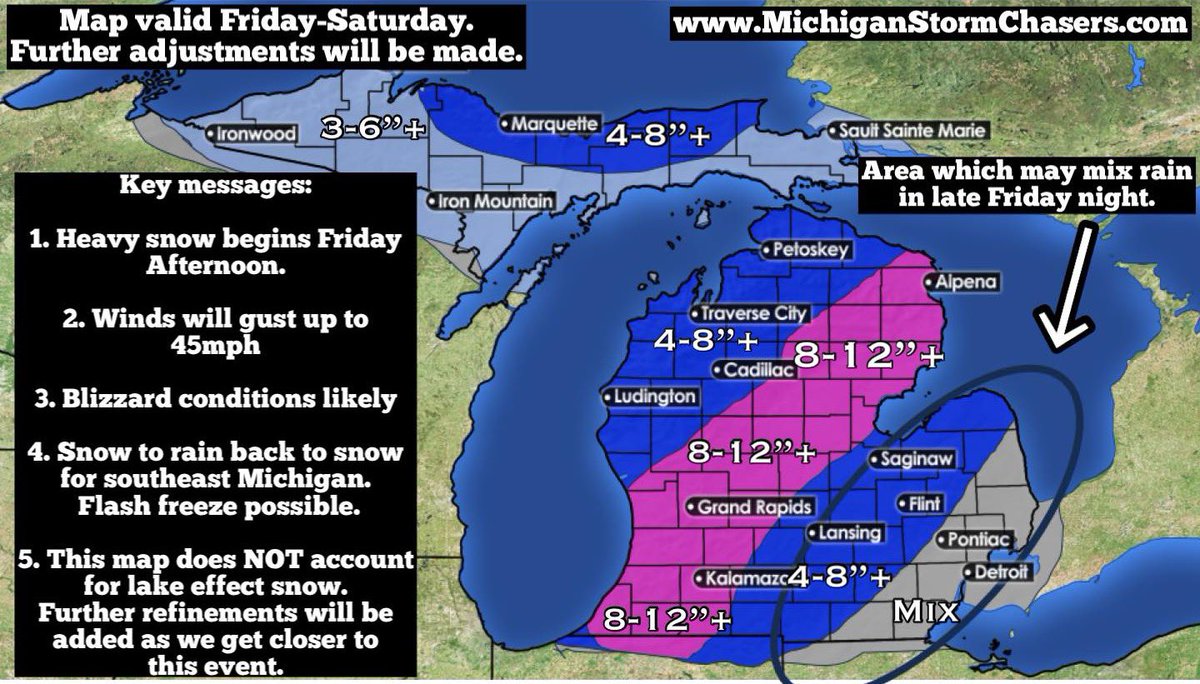
The heaviest snow will fall across a large portion of lower Michigan. We’ve designated an area of 8-12”+ where we believe the heaviest swath of snow will fall, along with 4-8”+ around the heaviest swath. If models do not budge off current data, we will likely need to raise these totals slightly. Given we are still a couple days away, we will allow time for more data to be analyzed and adjust if needed as we get closer to Friday.
SOUTHEAST MICHIGAN:
The black circle of uncertainty returns to the map. We’ve highlighted this area in southeast Michigan as an area we currently think will briefly change to rain Friday evening. We are currently watching a “battle” between models which shift the storm track west vs east. A western track brings the possibility of rain into the forecast while an eastern track supports an all snow forecast. The current trend of models has been west, but this mornings models have ever so slightly shifted back east. Regardless, we are highlighting this area for potential rain.
Now let’s assume for a minute that the low tracks more west, and thus rain will occur for SE MI. This would happen late Friday evening for around a 3 hour period. As soon as the low tracks off to the north, snow and cold air will fill back in quickly, potentially causing flash freezing as rain will freeze quickly on untreated surfaces. Regardless of scenario, there are still risks involved for SE MI. If rain cuts in, expect accumulations to remain much less, probably in the 1-4” range with locally higher amounts. The further north and west you are, the higher your chance of all snow is.
FINAL THOUGHTS:
This is one of those situations where we would definitely advise you to get your grocieries and essentials before this storm hits. Travel disruptions are likely between the significant snowfall, intense winds, and potential for flash freezing in the southeast zone. Power outages are possible given strong winds and excess weight of snow. Cold air will move in behind the low and we will not see a day above freezing for quite some time. More on the arctic blast at a later time.
Not trying to “hype” this system up, but it’s definitely one of the more potent systems we’ve seen in awhile
Map will be adjusted