Tornado watch continues until 9pm -Harris, Ft. Bend, Montgomery, Brazoria, Chambers, Galveston, Polk, San Jacinto, and Liberty counties. Strong storms moving through eastern 2/3 of SE Texas, will continue bringing heavy rain, gusty winds & possibly hail or tornadoes today.
The Storm Prediction Center has the majority of SE Texas under a threat of severe weather on Saturday, which includes a tornado risk, as well as possible flooding. #Houston#SevereWeather#storms#Spring#Saturday
Did you know that almost 25% of Houston's record high temperatures have been set in the last ten years!? Looks like we'll break another one today, and maybe tomorrow! #Houston#heat#weather#forecast#spring#heatwave
There's a chance of severe weather on Saturday for all of SE Texas. The chance is "slight" for most of the area, with severe storms even more likely for our eastern counties. #Houston#storms#severeweather#spring#Saturday
Storm chances later this morning and through the afternoon across Southeast Texas, some of which could become severe. Some lingering showers later tonight as this storm exits the area. Otherwise muggy and warm! #Houston#storms#rain#weather#forecast
Our southwest counties - Brazoria, Matgorda, Ft. Bend, Colorado, Wharton and Jackson counties, are still under a flood watch until 7pm. Storms are expected to fire up later this morning, and through the afternoon. #Houston#Weather#storms#spring
Strong winds plus very dry air this afternoon have prompted a red flag warning across most of SE Texas, for areas east of I-45. This means that the risk of wildfires to break out and spread rapidly is critical.
Widespread showers and storms are moving through SE Texas, with strong straight line winds of 60mph, numerous lightning strikes and very heavy rain. This activity will continue through the morning followed by a gusty, but dry, afternoon.
Considering December brought tornadoes, January brought snowmen and February brought springtime, today is about as perfect as you can ask for! #winter#warm#Houston
Fog is bad this morning - dense and widespread across SE #texas. Expect low to NO visibility for most of the morning, before the sunshine takes center stage along with beautiful afternoon weather! #winter#Weather#FOG
Once this morning fog gets out of the way, your Tuesday will be warm and sunny, with highs above average in the 70s. This is more like it! #weather#winter#Houston
The extreme cold warning for SE #texas this AM, has been extended til 12pm..the Cold Weather Advisory for tonight, is also extended, now expiring Friday 12pm. This shows how cold we are & indicates dangerous wind chills will be here through tomorrow. As of 11am, wind chills were still in the teens in some parts of the area #winter #weather #houston #arcticblast
Wind chills in SE #texas this morning. 7 DEGREES in our northern counties! But don't look north, the windchill in Rapid City takes the cake at -31 degrees...it's a frozen, icy cake. #winter#houstong#texas
Extreme Cold Warning in effect for another half hour. And if you haven't had enough winter yet, the National Weather Service has issued a cold weather advisory for tonight, for wind chills down to 20 degrees. Bundle up...and down...all around. #houston#winter#cold#freeze
Wind chills in Houston today will be stuck in the 20s for most of the morning, 30s in the afternoon, and drop again tonight when temperatures tumble again1 #houston#winter#arcticblast
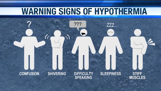
Hypothermia can set in quickly when temperatures drop! If you or someone else is shivering uncontrollably, confused, or feeling drowsy, it could be a warning sign. 🆘
👉 Wear warm layers
👉 Stay dry and out of the wind
👉 Seek shelter & warmth if you feel chilled
Know the signs, stay warm, and help others stay safe! 🔥 #StayWarm #HypothermiaAwareness #WinterSafety
Radar-indicated rainfall from Tuesday night. Some parts of SE #texas saw 3 inches of rain! There was even some hail near Atascocita that was picked up by the radar. #Winter#Houston
Strong storms are currently moving over the Houston metro area. Our radar is showing numerous lightning strikes, and rainfall rates of over 2 inches per hour. Do not go outside if you don't have to, and wait at least 30 minutes until the storm has passed.
Houston, brace yourselves! An icy wave of polar air is approaching. By Wednesday morning, temperatures will feel as low as 15 degrees. Alerts and advisories are in place. Keep warm and bring your pets indoors! #ColdFront#StayWarm
A wind advisory has been issued for most of SE #Texas, including Harris County, for gusts up to 40mph starting later tonight and lasting through Wednesday morning.