☀️ Stay safe this National Heat Stroke Day! As temperatures rise, remember to stay hydrated, take frequent breaks in shaded areas, and check weather and safety data to prevent heat-related illnesses. #HeatStrokeAwareness#WeatherSafety
Another day with showers and thunderstorms across southern Florida maintains the chance of flash flooding along the east coast. Conditions will improve tomorrow.
4/17 - One final round of showers and thunderstorms today before drier weather makes a return to our region tomorrow. A few isolated storms on the stronger side are possible today while the risk of localized flooding along the east coast remains with us. Let's discuss! (1/5)
Widespread severe thunderstorms are expected from this afternoon across portions of the Middle Mississippi Valley and Mid-South vicinity, eastward to the Lower Ohio and Tennessee Valleys. Chance of damaging gusts and several tornadoes, some strong and long-track.
An outbreak of severe weather is expected from the Lower Mississippi Valley toward the lower Ohio Valley Friday afternoon and evening. The chance of strong tornadoes is high. Today is a day when weather forecasting can save lives.
March 24, 2023: An outbreak of severe thunderstorms is expected this afternoon into tonight across the Lower Mississippi Valley. Tornadoes (a few EF-2 or greater in intensity), as well as damaging winds greater than 75 mph, and hail are expected.
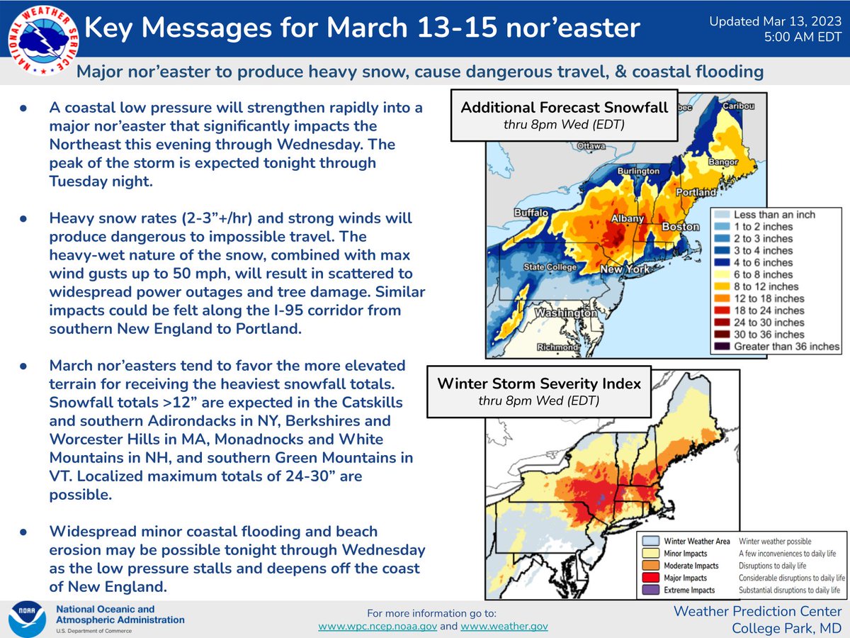
On the other coast, a major Nor'easter affects New England with heavy snowfall inland and rainfall over the coast. The cities most affected will be NYC and Boston, where some snow and sleet with very strong winds will also be possible.
https://t.co/1kGO2tEgJI
[5 AM EDT Tuesday] - Here are the latest Key Messages on the major Nor'easter set to bring additional heavy snowfall, strong winds, and coastal flooding to the region through tonight.
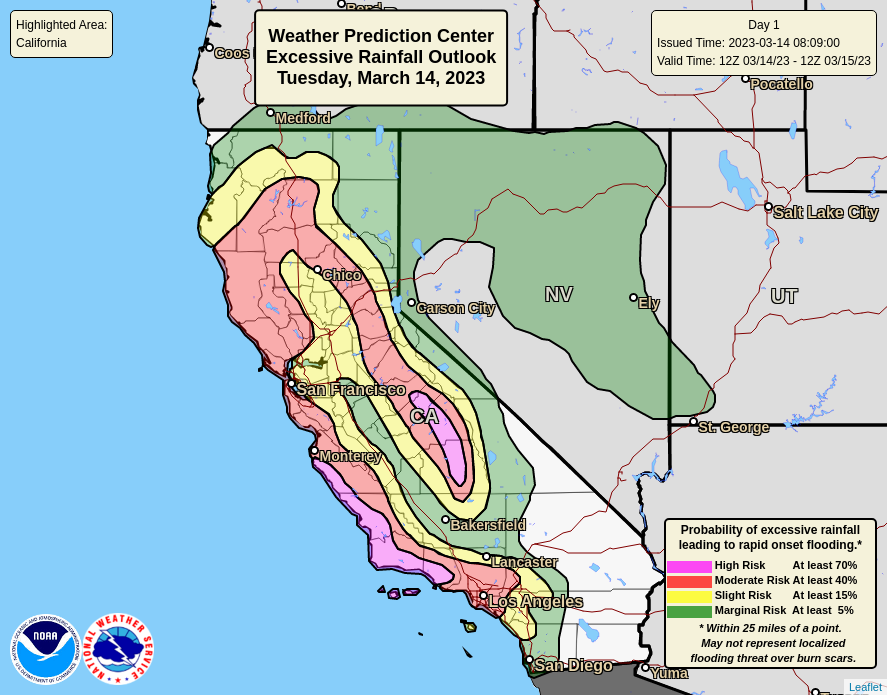
Another atmospheric river is forecast to reach California, and renews the chances of flash floods, excessive rainfall, and disruptions to road networks. Significant rainfall will affect cities such as San Francisco, Los Angeles, and San Diego.
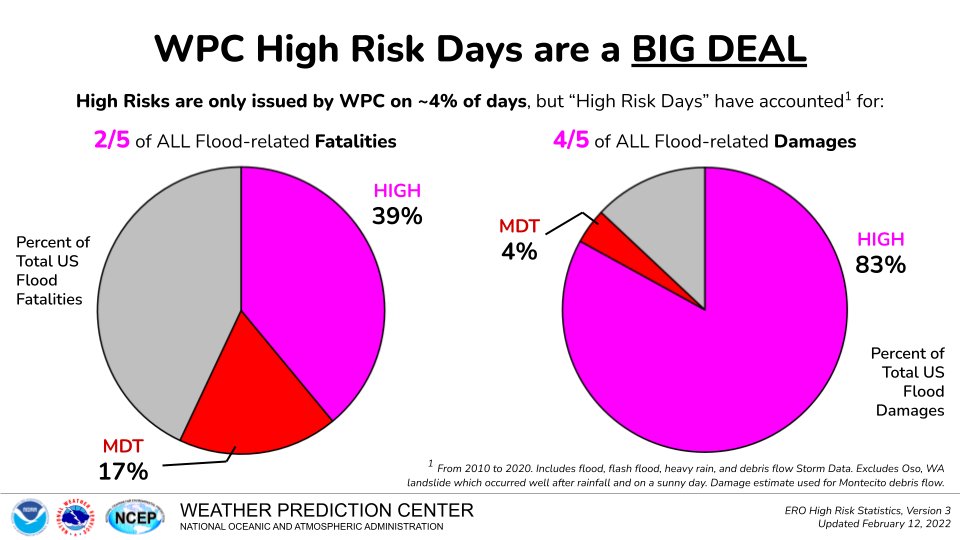
More dangerous flooding is expected over Central and Southern CA today with another strong atmospheric river. 40% of ALL flood related fatalities and 80% of ALL flood related damages occur within WPC High Risks. Be prepared to act quickly should a warning be issued for your area.
An intense subtropical atmospheric river will reach California today. It is time to pay close attention to the forecast! Flash flooding, excessive rainfall, high winds, and rapid melting of large amounts of snow can generate all kinds of disruptions in the region.
A storm arriving Thursday will bring a threat of flooding from a combination of heavy rain and snowmelt to lower elevations and foothills in California, especially below 5000 feet. And heavy, wet snow at higher elevations will lead to difficult travel and impacts from snow load.
A deep low-pressure system will result in severe weather and tornado risk. These types of situations show how important weather forecasting is to saving lives. 👇🌪️
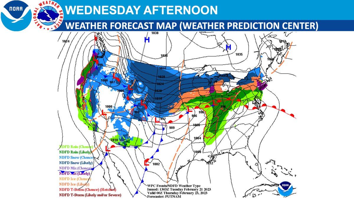
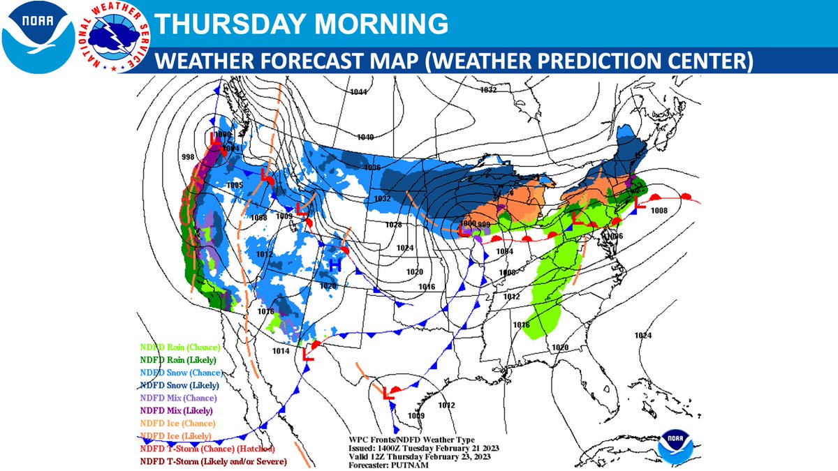
A significant storm system will bring severe thunderstorms, including tornadoes, and heavy rain which may produce flash flooding to the central U.S. on Thursday then move into the Great Lakes and Northeast with heavy snow and ice Friday and Saturday. https://t.co/VyWINDkBnn
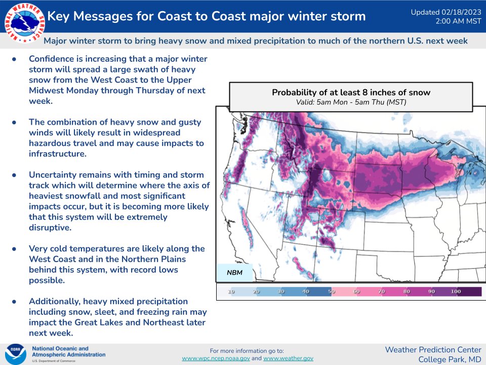
A massive winter storm will impact a large portion of the US the next few days. Hazards will include widespread heavy snow, blizzard conditions, a zone of sleet and freezing rain, high winds, severe thunderstorms and record low/high temperatures.
https://t.co/VyWINDk3xP for more.
With no precedent, mountains around Los Angeles will have risk of blizzard from next Friday to Saturday. Travel could be very difficult to impossible. Very strong winds could cause extensive tree damage.
Due to the potential for strong winds and heavy snow, a BLIZZARD WARNING was issued for the #LACounty and #VenturaCounty mountains from 4 am Friday to 4 pm Saturday. Snow accumulations up to 5 feet and wind gusts in excess of 55 mph are expected. #CAsnow#CAwx
We begin a week with a high chance of a massive winter storm affecting much of the northern US. There will be large areas with hazardous driving conditions and chances of blizzard conditions.
Confidence is increasing that a major winter storm will bring heavy snow and considerable impacts to a large portion of the northern United States next week.
A winter storm over the Four Corners will spread heavy snow across the Southern Rockies and Central Plains today, continuing through the Corn Belt into the Great Lakes on Thursday. Risk of blizzard over the Southern High Plains.
Today it will be important to keep an eye on the forecast for much of the central and northern USA. Heavy to severe storms in the south, transition from mixed precipitation to heavy snow in the central Plains and Central Rockies.
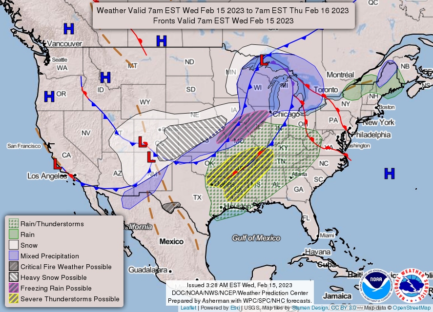
"Widely scattered severe thunderstorms are possible over parts of TX and OK beginning late in the day and into the evening on Wednesday. A severe threat will also develop overnight over the lower Mississippi Valley/Mid-South region, with a tornado risk" as @NWSSPC informed today.
Prolonged and potentially significant icing event to impact a large area from the southern Plains to the Tennessee Valley. Hazardous travel conditions will remain for much of the week.
Potentially hazardous winter weather is anticipated for a wide swath of the US today through at least mid-week. Check for the latest at https://t.co/VyWINDkBnn and ensure that you and your family are #WeatherReady