GOES-West (-17) 1-min visible imagery providing great depiction of Hurricane Darby center of circulation this morning. Animation is 5-hour-long storm-relative.
The predicted peak of the annual #Lyrids is 4:00 UTC on Friday. Your best bet? Watch in the late evening, before moonrise, on both April 21 and April 22. Here are more tips for watching this year's Lyrid meteors: https://t.co/8kvoYYSILt ☄️
📸 Guy Ottowell
Tropical Storm #Mindy Advisory 1: New Tropical Storm Forms in the Northeast Gulf of Mexico. Tropical Storm Warnings Issued For the Florida Panhandle. https://t.co/VqHn0u1vgc
ECMWF velocity potential anomalies 🌀
Like last year, forcing is favored over Africa and the Indian Ocean during peak hurricane season, a pattern consistent with an active tropical Atlantic and the hand print of a redeveloping La Niña.
A long-lived season also appears possible.
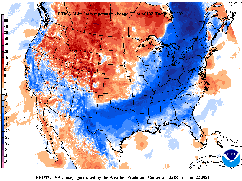
A cold front moving through the East and South shows up nicely in the 24 hour temperature change as of 9 am EDT on June 22, 2021. Some areas have dropped 20F+. 😱
00Z ECMWF vs GFS (6/14)
Yellow to Red = GFS is wetter
Green to Blue = ECMWF is wetter
Notice the difference in the projected rainfall from the tropical system coming out of the Bay of Campeche.
They also differ in this weekend's frontal boundary and central US low-pressure sys.
Here is the 7 AM Tropical Weather Outlook. The National Hurricane Center is giving the area of disturbed weather near the Bay of Campeche a 60% chance of development over the next 5 days. Keep up with the forecasts.
ERCOT is requesting energy conservation at this time. Consumers and businesses are urged to reduce their electricity use this afternoon and into the evening.