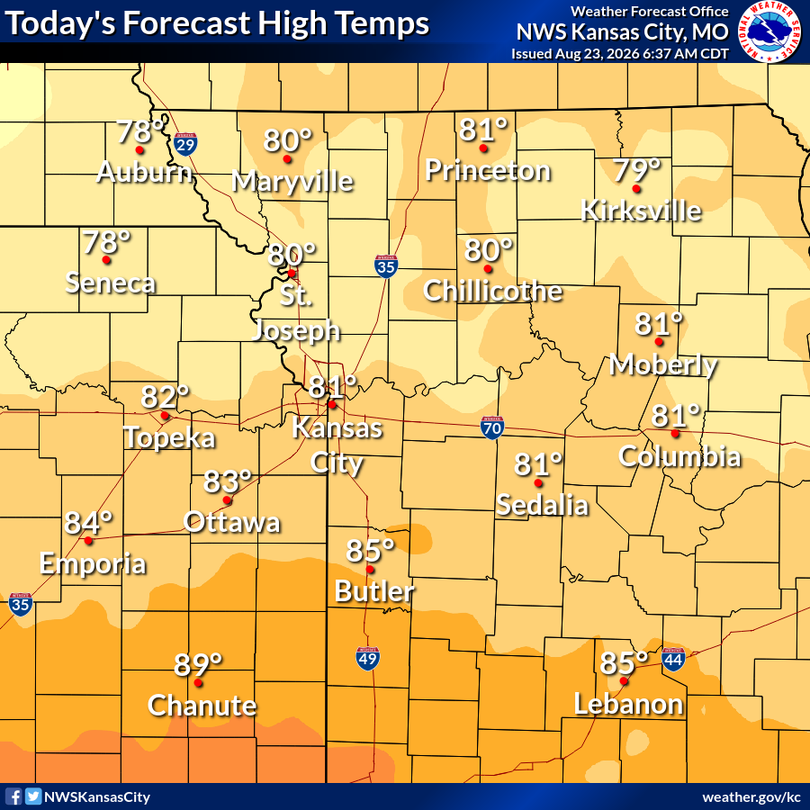
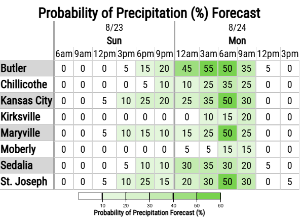
Below normal temperatures are expected today, with afternoon highs in the upper 70s to lower 80s for most locations. Shower and thunderstorm chances return late tonight into Monday morning, primarily for eastern Kansas and far western Missouri.
At 1:39 AM CDT, 2 NW Kansas City Kansas [Wyandotte Co, KS] Broadcast Media reports Tstm Wnd Dmg. Large walnut tree fell on home and vehicles. Downed powerlines. Time estimate via radar. #kswx https://t.co/9jiWsxcCg5
Hot and humid conditions are expected across the region this afternoon into the evening. Scattered thunderstorms are expected this evening into the overnight hours, a few of which may produce gusty winds and locally heavy rainfall.
EAX issues Flood Watch valid at Aug 15, 1:00 AM CDT for Adair, Daviess, Grundy, Harrison, Linn, Livingston, Macon, Mercer, Putnam, Schuyler, Sullivan, Worth [MO] till Aug 15, 10:00 AM CDT https://t.co/Y5z2JtrdSC
🌡️ Heat and humidity highlight the first half of the work week, including heat index values in excess of 105 for some.
🥵 This pushes HeatRisk into the Major Category at times.
❓Northern areas of Missouri are most uncertain, as cloud cover may keep the worst heat and at bay.
Showers and thunderstorms have developed in central MO this morning, and we are watching stronger storms currently Iowa that may try to sneak just south of the state line.
More development is expected this afternoon and evening.







![iembot_eax's tweet photo. At 5:46 PM CDT, 4 W Stanley [Johnson Co, KS] ASOS reports Tstm Wnd Gst of M64 MPH #kswx https://t.co/lbnnSZ6C2Z https://t.co/Ab20tum99A](https://pbs.twimg.com/media/HQR_e2rW0AANlz-.jpg)


![iembot_eax's tweet photo. At 5:02 PM CDT, 3 E Jarbalo [Leavenworth Co, KS] Public reports Tstm Wnd Gst of M59 MPH. PWS recorded 59 mph wind gust. #kswx https://t.co/um57ZFq9bQ https://t.co/HLzyzQBVko](https://pbs.twimg.com/media/HQR1WEVXoAAZw9o.jpg)

![iembot_eax's tweet photo. At 1:39 AM CDT, 2 NW Kansas City Kansas [Wyandotte Co, KS] Broadcast Media reports Tstm Wnd Dmg. Large walnut tree fell on home and vehicles. Downed powerlines. Time estimate via radar. #kswx https://t.co/9jiWsxcCg5 https://t.co/KqwKfOy5Wq](https://pbs.twimg.com/media/HQFOydFXgAAr0Kh.jpg)


![iembot_eax's tweet photo. EAX issues Flood Watch valid at Aug 15, 1:00 AM CDT for Adair, Daviess, Grundy, Harrison, Linn, Livingston, Macon, Mercer, Putnam, Schuyler, Sullivan, Worth [MO] till Aug 15, 10:00 AM CDT https://t.co/Y5z2JtrdSC https://t.co/F0jwEEq397](https://pbs.twimg.com/media/HPux-1ZXkAA7-H9.png)


