Tropical Weather Outlook
NWS National Hurricane Center Miami FL
1100 AM PDT Sun Jul 12 2026
For the eastern and central North Pacific east of 180 longitude:
1. Offshore of Southwestern Mexico:
A tropical wave associated with a broad area of low pressure located several hundred miles south of the coast of southern Mexico continues to produce a large area of disorganized showers and thunderstorms. Environmental conditions remain favorable for gradual
development of this system, and a tropical depression is expected to form during the early to middle part of the week while the system moves generally west-northwestward, well off the coast of Mexico.
* Formation chance through 48 hours...medium...40 percent.
* Formation chance through 7 days...high...90 percent.
2. Central and Western East Pacific:
An area of low pressure located well west-southwest of the Baja California Peninsula continues to produce disorganized showers and thunderstorms primarily east of its center. Some additional development of this system is possible over the next day or so before it moves west-northwestward into a less favorable environment.
* Formation chance through 48 hours...low...20 percent.
* Formation chance through 7 days...low...20 percent.
3. Well South of the Hawaiian Islands:
A trough of low pressure located several hundred miles south of the Hawaiian Islands is producing a large area of disorganized showers and thunderstorms. Gradual development of this system is possible during the next several days as it drifts slowly westward in the central Pacific, remaining well south of the Hawaiian Islands.
* Formation chance through 48 hours...low...10 percent.
* Formation chance through 7 days...low...30 percent.
4. Well Southwest of the Hawaiian Islands (Ex-CP90):
A trough of low pressure located several hundred miles to the southwest of the Hawaiian Islands is producing a concentrated area
of showers and thunderstorms. Environmental conditions appear favorable for gradual development of this system during the next several days as it moves slowly westward to northwestward, remaining southwest of the Hawaiian Islands.
* Formation chance through 48 hours...low...10 percent.
* Formation chance through 7 days...low...30 percent.
5. Offshore of Southern and Southwestern Mexico:
An area of low pressure is expected to form by the middle of this week several hundred miles south of the coast of southern Mexico. Environmental conditions appear conducive for gradual development of this system later this week, and a tropical depression could form by the end of the week while it moves generally west-northwestward well offshore of Mexico.
* Formation chance through 48 hours...low...near 0 percent.
* Formation chance through 7 days...medium...40 percent.
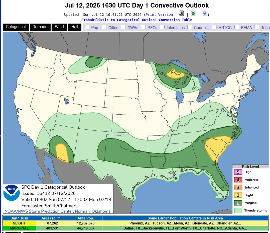
Day 1 Convective Outlook CORR 1 NWS Storm Prediction Center Norman OK
1141 AM CDT Sun Jul 12 2026 Valid 121630Z - 131200Z
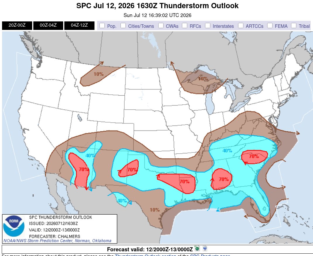
...THERE IS A SLIGHT RISK OF SEVERE THUNDERSTORMS ACROSS PARTS OF EASTERN GEORGIA INTO THE CAROLINAS...SOUTHERN/CENTRAL ARIZONA...AND THE UPPER PENINSULA OF MICHIGAN...
CORRECTED FOR OUTLOOK PROBABILITY LINES OVER GA/CAROLINAS
...SUMMARY...
Thunderstorms capable of producing isolated to scattered severe/damaging winds may occur this afternoon/evening across parts of the Carolinas/Southeast into the southern Plains, and separately over southern/central Arizona. Large hail and severe winds also appear possible over portions of the Upper Peninsula of Michigan.
...Carolinas/Southeast into the Southern Plains...
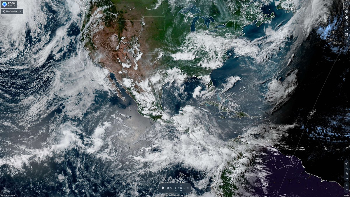
Midday visible-satellite imagery shows an agitated cumulus field over north-central GA to the south of a differential heating zone/weak front draped across the southern Appalachians and west to east across the Carolinas. Surface temperatures will continue to warm into the 90s F south of the more prevalent cloud cover over the Upstate of SC and western/central NC. Scattered thunderstorms will likely develop in several clusters across the Southeast with strong to locally severe gusts capable of wind damage being the primary hazard. Farther west, more widely spaced clusters will likely develop over the central Gulf Coast states into the Ark-La-Tex region. Locally damaging gusts will be possible with the stronger thunderstorms.
Into parts of the southern High Plains, a seasonably moist boundary layer will become moderately unstable by mid afternoon. Steep 0-3 km lapse rates will favor isolated severe gusts with the stronger downdrafts. Considered a small Slight Risk over the TX South Plains but some uncertainty regarding storm coverage precluded higher severe probabilities this outlook update.
...Upper Midwest/Great Lakes...
Northwest-flow regime will maintain a plume of elevated mixed layer air atop a moist low-level airmass. It is uncertain whether additional storm development will occur this afternoon in association with a morning cluster of strong to severe storms over parts of the U.P. Nonetheless, sufficient shear/buoyancy for supercells and organized storms structures lends a continued conditional risk for severe storms into this evening/tonight. Some guidance shows an eventual outflow-dominant cluster moving into parts of the region tonight, with some potential for damaging gusts.
...Arizona...
Very strong heating will again yield a hot and well-mixed boundary layer by mid afternoon. Isolated to scattered storms are forecast to develop on the Rim and gradually propagate into the lower desert, aided by moderate easterly mid-level flow (30-kt at 500 mb sampled by the 12 UTC Phoenix raob). Strong evaporative cooling of the more water-laden downdrafts will be capable of severe gusts (60-75 mph).
...Montana...
A weak front along with very strong heating may suffice for a few high-based thunderstorms to develop late this afternoon across north-central MT. Very steep low to mid-level lapse rates and deep inverted-V profiles imply some potential for severe gusts with the stronger evaporatively cooled downdrafts.
ecord Heat for the Intermountain West and Northern Plains; Heavy Rainfall and Severe Weather Threats
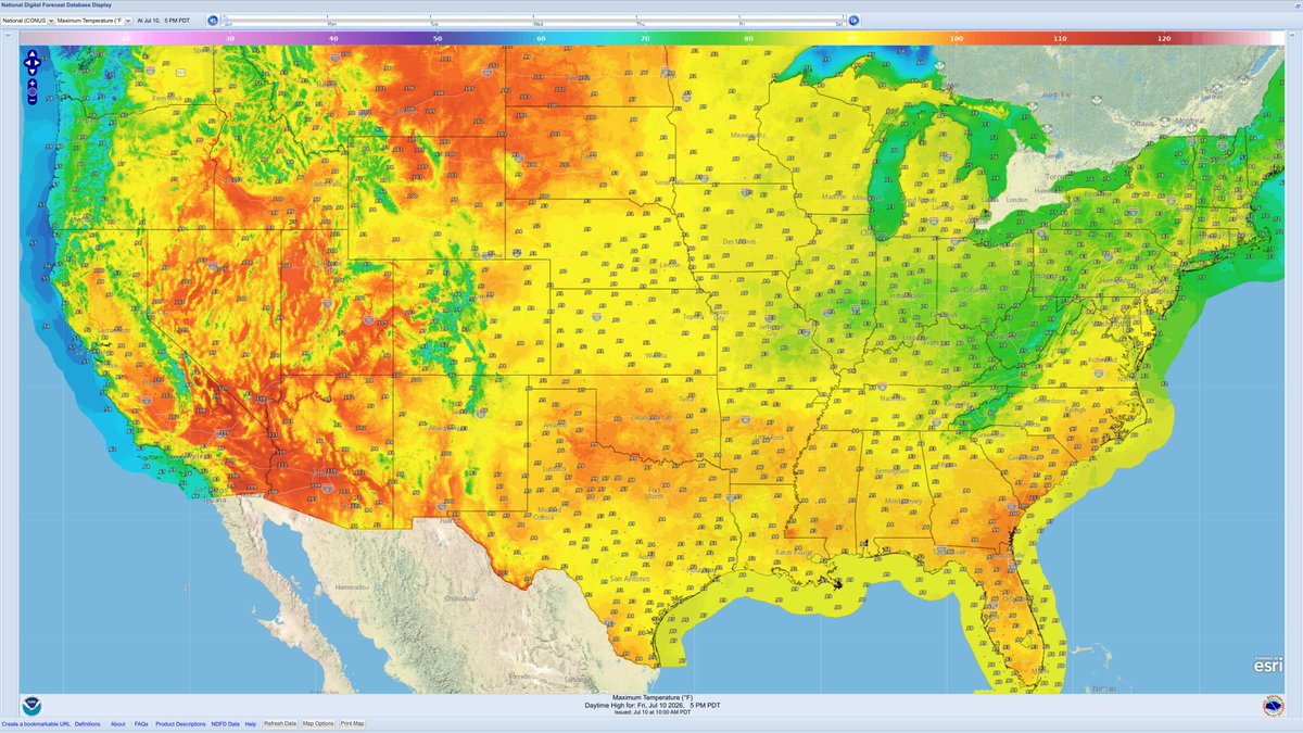
👉 Record setting heat is expected over the next several days from the Intermountain West through the northern Plains. Furthermore, fire weather concerns increase with dry and breezy conditions. Meanwhile, heavy rainfall and severe thunderstorm threats for the Ohio/Tennessee Valleys, central Appalachians and Southeast today. The threat shifts to central Gulf Coast and across central Texas this week. Read More >
https://t.co/m5MttXMmk4
Tropical Weather Outlook
NWS National Hurricane Center Miami FL
1100 AM PDT Sat Jul 11 2026
For the eastern and central North Pacific east of 180 longitude:
1. Offshore of Southwestern Mexico:
A broad area of low pressure is located several hundred miles south of the southwestern coast of Mexico. Environmental conditions appear favorable for gradual development of this system, and a tropical depression is likely to form by mid-next week while the system moves generally west-northwestward. * Formation chance through 48 hours...low...30 percent. * Formation chance through 7 days...high...90 percent.
2. Central and Western East Pacific:
Showers and thunderstorms have increased during the past several hours in association with a trough of low pressure located well southwest of the Baja California peninsula. Some slow development of this system is possible over the next couple of days. By the middle of next week, environmental conditions are expected to become less conducive for development while it moves slowly west-northwestward.
* Formation chance through 48 hours...low...20 percent.
* Formation chance through 7 days...low...20 percent.
3. Well Southeast of the Hawaiian Islands:
A trough of low pressure located several hundred miles southeast of the Hawaiian Islands is producing disorganized showers and thunderstorms. Environmental conditions appear favorable for gradual development of this system, and a tropical depression could form by mid-next week while it moves generally westward across the central Pacific, remaining well south of the Hawaiian Islands.
* Formation chance through 48 hours...low...10 percent.
* Formation chance through 7 days...medium...40 percent.
4. South of the Hawaiian Islands (formerly CP90):
A trough of low pressure, located several hundred miles south of the Hawaiian Islands, is producing a small area of showers. Further development of the system appears to be unlikely while it moves generally westward across the central Pacific, remaining well south of the Hawaiian Islands.
* Formation chance through 48 hours...low...near 0 percent.
* Formation chance through 7 days...low...10 percent.
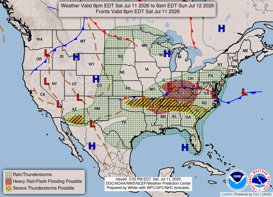
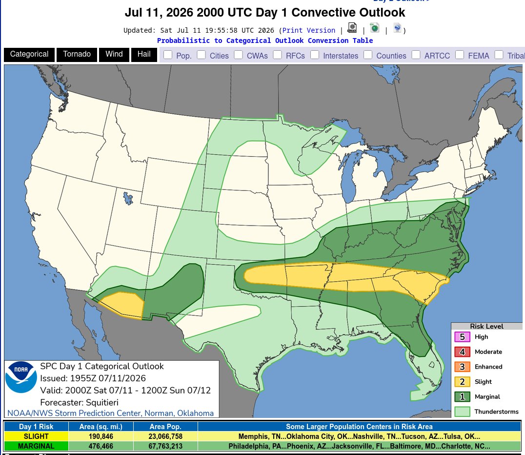
Day 1 Convective Outlook NWS Storm Prediction Center Norman OK
0255 PM CDT Sat Jul 11 2026 Valid 112000Z - 121200Z
...THERE IS A SLIGHT RISK OF SEVERE THUNDERSTORMS FOR PORTIONS OF CENTRAL OKLAHOMA TO THE CAROLINA SHORELINE...AND SOUTHERN ARIZONA...
...SUMMARY...
Thunderstorms capable of producing scattered severe/damaging winds will remain possible this afternoon and evening from parts of the southern Plains eastward into the lower Mississippi Valley and Southeast. Scattered severe wind gusts are still possible over southern Arizona late this afternoon through the evening.
...20Z Update...
The previous forecast (see below) remains largely on track. The only appreciable change made to the 20Z Day 1 Outlook was to trim severe probabilities from the TX Panhandle. Here, subsidence and stability persist, with MLCINH of at least -100 J/kg in place amid minimal low-level convergence or upper support to encourage diurnal thunderstorm development. However, a few nocturnal storms may form due to impinging convective outflow from OK. Elsewhere across the CONUS, only minor changes were made to the general thunder and severe probabilities to reflect the latest observations and guidance consensus.
..Squitieri.. 07/11/2026
.PREV DISCUSSION... /ISSUED 1130 AM CDT Sat Jul 11 2026/
...Southern Plains/Ozarks into the Tennessee Valley/Southeast and Mid-Atlantic... Weak mid-level troughing with multiple embedded and convectively enhanced vorticity maxima (i.e., several MCVs evident in radar mosaic/satellite imagery) will advance slowly eastward across the mid MS Valley into the lower OH Valley/Midwest and TN Valley and
southern Appalachians. A developing thunderstorm cluster over the Upstate of SC will likely move east towards the Carolina coast later today. Ahead of this cluster, strong heating with temperatures warming into the 90s with lower to mid 70s F dewpoints will result in a moderately unstable airmass. Westerly low-level flow will imply the wind risk will likely overspread the coast.
Isolated damaging winds may also occur farther north along/near a weak synoptic front, but less instability is forecast with northward extent into the OH Valley and Mid-Atlantic.
Farther west, several clusters may evolve across the Mid South with damaging gusts the primary severe hazard. Visible-satellite imagery shows an MCV over northwest OK moving east. The airmass south of a stalled frontal zone will undergo strong heating via clear skies through mid afternoon. Short-term model guidance (HREF, HRRR-RRFS time-lagged ensemble) show scattered storms developing across north-central OK by 21-23 UTC. A well-mixed boundary layer will support strong evaporatively cooled downdrafts capable of severe gusts with the more intense single and multicells. Have expanded the Slight Risk to account for this increased confidence in a severe threat across central OK.
...Southern Arizona...
With a mid-level anticyclone centered over the Four Corners, a weak easterly mid-level flow regime is present today across the Sonoran Desert. Very strong heating will result in a deeply mixed boundary layer and this was depicted on the 12 UTC Phoenix raob, with an accompanying 11.6 g/kg lowest 100-mb mean mixing ratio. Forecast soundings show 20-kt easterly flow in the mid levels atop weak westerly surface flow. Very steep low- to mid-level lapse rates and inverted-V thermodynamic profiles will strongly favor evaporatively cooled downdrafts with the more intense cores. Severe gusts 60-80 mph appear likely with the stronger microbursts. This activity will likely transition from a few cells into an outflow-dominant cluster
during the evening and coincide with a greater prevalence of severe gusts. Isolated hail may also occur with the stronger cores.
Severe Thunderstorms and Heavy Rainfall Today from the Central Plains into the Tennessee Valley
👉 Severe thunderstorms capable of damaging winds will be possible from the Ozark Plateau east into portions of the Southeast today. Rounds of heavy thunderstorms ahead of a slow moving front will continue locally heavy rainfall and scattered flash flooding potential from the Ozarks to the Ohio and Tennessee Valleys today. Read More >
https://t.co/m5MttXMmk4
Tropical Weather Outlook NWS National Hurricane Center Miami FL
1100 AM PDT Fri Jul 10 2026
For the eastern and central North Pacific east of 180 longitude:
1. South-Southeast of the Hawaiian Islands (CP90):
Shower and thunderstorm activity associated with a trough of low pressure located several hundred miles south-southeast of the Hawaiian Islands has diminished slightly since yesterday. However, environmental conditions appear conducive for gradual development of this system through early next week, and a tropical depression could form while the system moves generally westward across the central Pacific, remaining well south of the Hawaiian Islands.
* Formation chance through 48 hours...medium...40 percent.
* Formation chance through 7 days...medium...50 percent.
2. Well Southeast of the Hawaiian Islands:
A trough of low pressure with a small cluster of showers and thunderstorms continues to move generally westward and is located about 800 miles southeast of the Hawaiian Islands. Environmental conditions appear favorable for some slow development of this system, and a tropical depression could form next week as it moves mainly westward over the central Pacific, remaining well south of the Hawaiian Islands.
* Formation chance through 48 hours...low...near 0 percent.
* Formation chance through 7 days...medium...50 percent.
3. Offshore of Southwestern Mexico:
An area of low pressure is expected to form late this weekend or early next week several hundred miles south-southwest of the coast of southwestern Mexico. Environmental conditions appear favorable for gradual development thereafter, and a tropical depression is likely to form next week while the system moves generally west-northwestward.
* Formation chance through 48 hours...low...near 0 percent.
* Formation chance through 7 days...high...70 percent.
4. Central and Western East Pacific:
Another area of low pressure could form by early next week well southwest of the Baja California peninsula. Some slow development of this system is possible next week while it moves slowly northwestward.
* Formation chance through 48 hours...low...near 0 percent.
* Formation chance through 7 days...low...20 percent.