Signs You're Not Okay Mentally (Even If You Think You Are)
1. You feel exhausted all the time, even when you haven’t done much.
2. You replay conversations in your head and overthink the smallest things.
3. Your mind never seems to switch off, or it goes completely blank when you need it most.
4. Things that used to make you happy just don’t hit the same anymore.
5. You start avoiding texts, calls, and people, even the ones you care about.
There was a guy in our office nobody talked to.
Sat in the corner, ate lunch alone, left at 5:01 sharp every day.
We called him boring behind his back.
Last month he quit with no warning.
HR sent the usual “thanks for your service” email.
Nobody replied.…
Some accumulating snow will be possible late Friday night & Saturday, especially along & north of I-80. The highest probability for 1 inch or more of snow accumulation currently appears will occur from far NE IA into NW IL. There is still some uncertainty on the amounts.
Light to moderate snow is forecast to spread northeastward across the area this evening. Expect quick reductions in visibility, blowing snow and gusts up to 55 MPH. Slick travel is possible! Check road conditions before traveling.
Winter Weather Advisory 3 PM today thru 9 AM Monday for hazardous conditions produced by high winds producing blowing snow reduced visibility especially in rural/open areas. Plummeting temps may also cause a flash-freeze & icy roads. Highest snow amounts along Hwy 20.
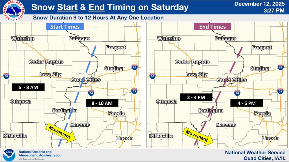
The general timing of the snow today shows the southern areas seeing the snow developing first with a northward expansion through mid-day. The heaviest snowfall rates look to be from 9 AM to 1 PM. The snow will end from west to east during the afternoon into the early evening.
Snow is moving into southeast Iowa and will spread further east and north through 9 AM. With pavement temperatures below freezing, snow will quickly accumulate on roads resulting in deteriorating conditions through 9 AM.
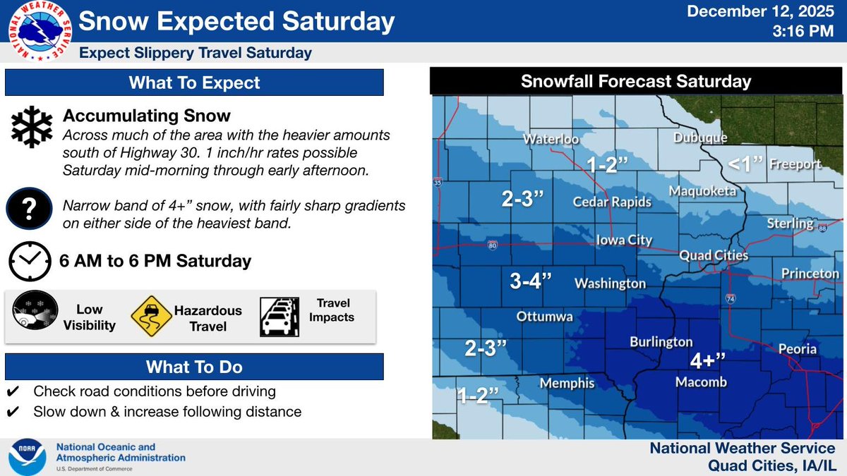
Another clipper system will bring accumulating snow to much of the area today. The accumulating snow will be mainly along/south of Highway 30 with the higher amounts south of I-80. There will be sharp gradients of accumulation on either side of the heaviest snow band.
Here is a look at the general timing with the passing wintry system tomorrow. We will see this approach our west around 6AM, with snow lasting through the day and into the early evening. Heaviest snowfall rates are expected mid Sat AM and early PM. #iawx#ilwx#mowx
Another round of snow will move through the area Saturday, starting early in the day. Winter Weather Advisories are in effect for part of the area, with 2-4" expected along/south of Interstate 80. A narrow band of 4 plus inches of snow is possible south of I-80. #iawx#ilwx#mowx
Another storm system is forecast to bring accumulating snow to the area early this afternoon into tonight. Snowfall amounts of 2 to 4 inches are possible with isolated amounts up to 5 inches. This will impact the evening commute. Check road conditions before traveling.
Snow is forecast to overspread the area late this afternoon before ending overnight. Here is a look at the estimated start and end times for the snowfall.
A storm system is forecast to move across the area Saturday into Saturday night and bring another round of accumulating snow to the area. Currently there is a 40 to 60 percent chance of at least 2 inches of snow.
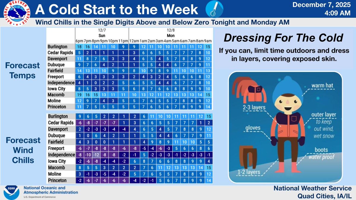
It will be quite chilly to start off the week. Temperatures will drop into the single digits above and below zero tonight into Monday morning, with wind chills as cold as -15. Be sure to dress appropriately if you will be outdoors for any length of time. #iawx#ilwx#mowx
Moderate to heavy snow is spreading through eastern Iowa, and will cover roads in Cedar Rapids and Iowa City through 7 PM. Expect roads to quickly become snow covered and slick, and visibilities to drop under 1 mile in snow.
Moderate to heavy snow is spreading east towards eastern Iowa, and will arrive into Cedar Rapids and Iowa City through 6 PM. Expect roads to quickly become snow covered and slick, and visibilities to drop under 1 mile in snow.
Here's an update on our snow Sat night - early Sun. It still looks likely (60-80%) that much of the area especially N of Hwy 34 will see at least 2", with probabilities at 40-70% for 4" or more for parts of E Iowa. Travel impacts likely. Stay tuned! #iawx#ilwx#mowx
Another wintry system is slated to impact the area Saturday night, which will be capable of accumulating snow. Early indications it's likely to bring 2 or more inches of snow to much of the area. Monitor the forecast for the latest details, especially if you have travel plans
An arctic cold front will move through on Wednesday and bring a frigid air mass into the region. Winds between 5 - 15 mph late Wednesday night into Thursday morning will create wind chills between 10 to 20 below for much of the area! #iawx#ilwx#mowx
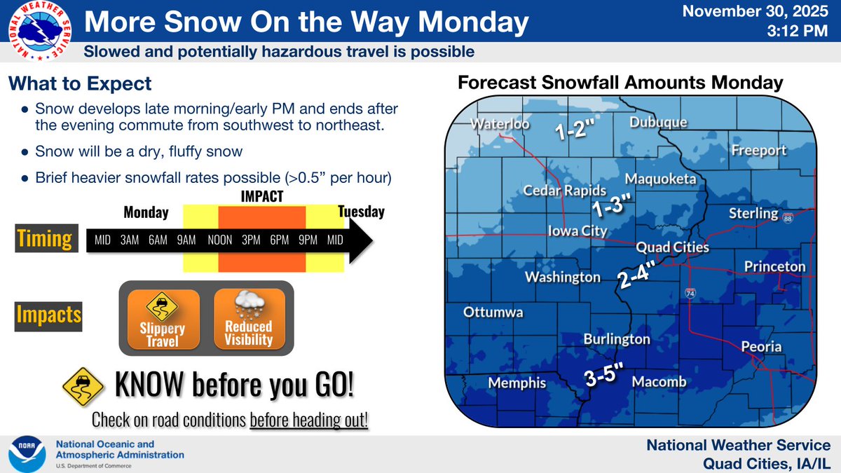
More snow is on the way Mon/Mon eve. Amounts will be much less with this system (3-5" possible mainly south of I-80). Many should see at least 1". It will be a dry, fluffy snow & winds will be light making for easier removal but slick roads & impacts to eve commute are possible.