Young surveyors protested last week, led by @MaxwellMbae.hich leads us here; the need for an honest conversation.
Is the surveying field really gatekept, or are we missing something?
Too many of us feel stuck.
Slow growth. Limited opportunities. No clear path.
It’s time for a real conversation.
X Space
8th May 2026
7:00PM – 8:00PM EAT
We’re breaking down:
• Career growth (expectation vs reality)
• Gatekeeping ; myth or reality?
• What needs to change
If you’re a young surveyor, your voice matters.
Set your reminder
Female Track Athlete of the Year nominee ✨
Repost to vote for Beatrice Chebet 🇰🇪 in the #AthleticsAwards.
Voting closes on Sunday 19 October at 11:59 PM CEST.
Male Track Athlete of the Year nominee ✨
Repost to vote for Emmanuel Wanyonyi 🇰🇪 in the #AthleticsAwards.
Voting closes on Sunday 19 October at 11:59 PM CEST.
Female Track Athlete of the Year nominee ✨
Repost to vote for @Kipyegon_Faith 🇰🇪 in the #AthleticsAwards.
Voting closes on Sunday 19 October at 11:59 PM CEST.
Why do we experience a shift of about 300 meters while we overlay Arc 1960 data on WGS84 data sets?
The ~300-meter shift between the Arc 1960 datum and the WGS84 datum arises because they are based on different reference ellipsoids and coordinate systems tailored to specific regions and purposes.
Different Reference Ellipsoids:
Arc 1960: Uses the Clarke 1880 ellipsoid, designed to fit the shape of the Earth in parts of Africa (e.g., Kenya, Uganda, Tanzania). It’s a local datum, optimized for regional accuracy.
WGS84: Uses the GRS80 ellipsoid, a global standard designed for worldwide consistency, especially for GPS and modern geospatial applications.
These ellipsoids differ in size, shape (flattening), and orientation, causing a systematic offset in coordinates when transforming between them.
Datum Definition and Origin:
Arc 1960 is a regional datum with its origin and parameters adjusted to minimize distortions in East Africa. Its reference points are tied to local survey networks.
WGS84 is a geocentric datum, aligned with the Earth’s center of mass, used globally for GPS. Its origin and orientation differ from Arc 1960’s, contributing to the shift.
Transformation Parameters:
The ~300-meter shift (which can vary slightly by location) comes from the differences in the datum’s origin (translation), orientation (rotation), and scale. The transformation parameters (e.g., translation in X, Y, Z coordinates) between Arc 1960 and WGS84 typically result in a horizontal displacement of around 200–400 meters, depending on the specific location in the Arc 1960 coverage area.
For example, transformation parameters for Arc 1960 to WGS84 in Kenya might include translations like ΔX ≈ -160 m, ΔY ≈ -120 m, ΔZ ≈ -300 m (approximate values; exact parameters depend on the region and specific transformation model).
Practical Impact:
The shift is most noticeable in the horizontal plane (latitude and longitude), translating to roughly 300 meters on the ground. Vertical (height) differences are usually smaller but still significant.
The exact shift varies slightly across the Arc 1960 region due to local distortions in the survey network and the non-uniform fit of the Clarke 1880 ellipsoid to the Earth’s surface.
Why This Happens: The Arc 1960 datum was developed before global satellite-based systems like GPS, using ground-based surveys that prioritized local accuracy. WGS84, designed for global consistency, uses a different ellipsoid and geocentric reference, leading to a systematic offset. To convert coordinates accurately, you’d use a transformation model (e.g., Molodensky or Bursa-Wolf) with region-specific parameters, which accounts for the ~300-meter shift.
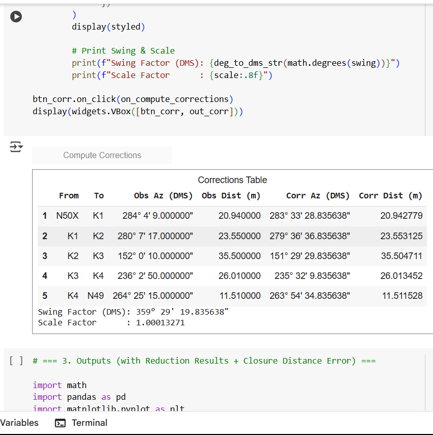
Just finished coding a tool to reduce a resection (raytrace) traverse; no more manual calculations! It;
Computes swing & scale factors
Spreads errors across traverse points
Checks accuracy within survey tolerances
Perfect for validating beacons & adjusting bearings in the field
Join attributes by field value in QGIS! Move data from an excel file into a vector layer i.e QGIS shapefile. Data used downloaded from GADM Maps and the 2019 KENYA POPULATION AND HOUSING CENSUS Report.
https://t.co/O5FhalBuU8
Chainmen are very important when working with a total station. The accuracy of a Surveyor's job is heavily dependent on their keenness and stability; especially during setting station and orienting.
Learn how to set out features using a TS here; https://t.co/B3wb3f2NaD
Learn how to set a total station over a known point and to backsight to a coordinate. Here is a video description on the process. Machine used; South N3 Series.
Full tutorial https://t.co/s43LteKmcA
Got a pile of layouts in AutoCAD and need to print them all at once?
Stop printing one by one — here's how to batch print in seconds.
Full tutorial is here; https://t.co/MuPtABsEZt
Learn how to set out with precision (step-by-step) using a Total Station; A Perfect tutorial for land surveyors, engineers & students working on design implementation.
Clear. Easy to follow.
@mutethia_karuma@Surveyor_001@Artisurvey#LandSurveying
https://t.co/B3wb3f2fl5
Look how simple it was to buy Bitcoin back in 2010. Just a few easy to understand fields. No complicated charts or distractions. That's why we love @bitika_KE for it's simplicity. Bitika is a throwback to the good ol days! Do one thing and do it well.