Digitalizando 20.000 ha de lotes agrícolas en #Turén, Venezuela en menos de 20 minutos con segment-geospatial en python. La tecnología al servicio del agro.
#remotesensing#geospatial#tercosdelcampo
Sería raro que en USA las masas prefieran un deporte inventado por los ingleses en lugar de un deporte inventado por ellos mismos y 18 años antes como lo fue el béisbol jaja
Es posiblemente la mayor muestra futbolística de Estados Unidos en toda su historia y lamentablemente los hinchas todavía no entienden porque no la están agarrando con las manos.
The US government, citing national security authorities, has issued an export control directive to suspend all access to Fable 5 and Mythos 5 by any foreign national, whether inside or outside the United States, including foreign national Anthropic employees.
The net effect of this order is that we must abruptly disable Fable 5 and Mythos 5 for all our customers to ensure compliance.
Access to all other Claude models is not affected.
We apologize for this disruption to our customers. We believe this is a misunderstanding and are working to restore access as soon as possible.
Read our full statement: https://t.co/bwn0sximKZ
Recién terminamos la clase de RAG en la maestría de Ciencia de Datos, y es impresionante cómo un profesor que te explique bien las cosas puede desbloquearte tantas ideas y proyectos que ahora ves totalmente posibles.
🇻🇪🇻🇪🇻🇪 voy a venezuela a armar la primera hackathon con Anthropic !!
(con muy pocas horas de sueño pero hay que echarle pichón).
mientras @rafafdz_ y el team @platan_ventures terminan la hackathon en 🇦🇷...
yo voy a estar en Caracas del 10 al 14 de mayo para la Venezuela Tech Week con la misión de:
- encontrar a los 25 mejores hackers/devs de caracas.
- y armar la hackathon mas arrecha de todas.
- y comer muchisimas arepas.
HEY, literalmente no conozco a nadie 😬.
así que pls pls, conéctenme con la gente que tenga que conocer si o si!!
nos vemos ahí !!
link en los comentarios!
One click, infinite masks! 🖱️
Learn how to use SAM (ViT-H) and OpenCV to generate segmentation masks from a single point.
Medium: https://t.co/STjRvkN2U3
Code: https://t.co/ph5MUrr7c3
#AI#Python#CV
Today we announced Planet SuperRes, a breakthrough tech that uses AI to uplevel our PlanetScope near-daily imagery from 3 m to a much sharper 2 m resolution. 🛰️
Really cool things done by our team to make this happen. The model was trained on over 120,000 SkySat and PlanetScope satellite image pairs. We can now see things we couldn’t before -- making small-scale objects and textures visible for analysis.
Better data helps us make better decisions. https://t.co/D7FgMUwR8C
Being able to execute complex GIS tasks via natural language in a fully Open Source way is a game-changer for our automation workflows. Superb as always @giswqs 👏
I am excited to introduce OpenGeoAgent, a powerful open-source multimodal AI agent for automated geospatial analysis and visualization!
It supports QGIS, Jupyter notebook, and Python scripting. In this tutorial, you’ll learn how to automate GIS workflows using natural language, generate maps, analyze satellite data, and even run complex hydrological models.
You can even interact with the agent using voice commands (no typing needed).
Video: https://t.co/mJ0ort5dzb
GitHub: https://t.co/WgiWV1wGMS
QGIS Plugin: https://t.co/qNRP3WPJWe
#geospatial #GeoAgent #OpenSource #AI
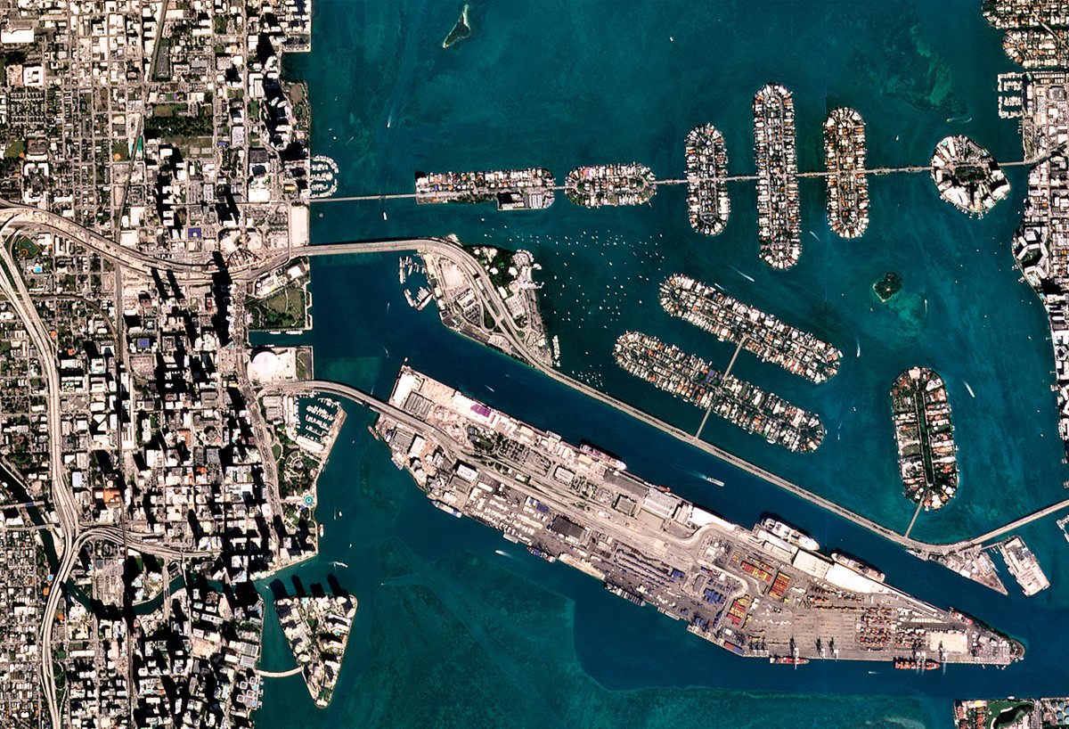
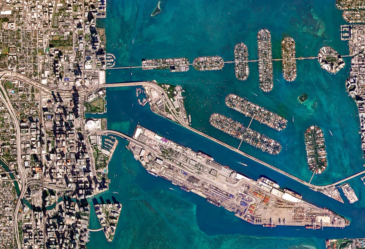
📍Miami International Airport: "That's something you haven’t seen up on the board for the past 7 years—Caracas, Venezuela."
A symbol of "how much has changed in Venezuela over the past 117 days since Nicolás Maduro was taken by U.S. forces."
For nearly 7 years there have been no direct commercial flights between the U.S. and Venezuela.
Under President Trump we're changing that today. Flights between Miami and Caracas restored.
An AI assistant for Google Earth Engine is now available in QGIS!
You can explore and visualize any dataset from the 80+ PB Earth Engine Data Catalog using natural language, and run scalable geospatial analysis on demand without writing code. Every interaction automatically generates reusable code, making it easy to reproduce results, customize workflows, and transition from no-code to full scripting when needed.
Upgrade the plugin to get started and bring AI-powered geospatial analytics directly into your QGIS workflow.
GitHub: https://t.co/NB4shvrL7b
QGIS plugin: https://t.co/o4wrN44uZr
GeoAgent: https://t.co/WgiWV1wGMS
#EarthEngine #QGIS #OpenSource #GeoAI #Geospatial
𝗙𝗼𝗿 𝘁𝗵𝗲 𝗳𝗶𝗿𝘀𝘁 𝘁𝗶𝗺𝗲 𝗶𝗻 𝗵𝗶𝘀𝘁𝗼𝗿𝘆, 𝗮𝗴𝗿𝗶𝗰𝘂𝗹𝘁𝘂𝗿𝗮𝗹 𝗳𝗶𝗲𝗹𝗱 𝗯𝗼𝘂𝗻𝗱𝗮𝗿𝗶𝗲𝘀 𝗵𝗮𝘃𝗲 𝗯𝗲𝗲𝗻 𝗺𝗮𝗽𝗽𝗲𝗱 𝗮𝘁 𝗴𝗹𝗼𝗯𝗮𝗹 𝘀𝗰𝗮𝗹𝗲.
I've been collaborating with the Fields of the World (FTW) organization for over a year through Taylor Geospatial and it's finally released publicly in cloud storage for anyone to use, at no cost.
𝗙𝗼𝗿 𝘁𝗵𝗲 𝗳𝗶𝗿𝘀𝘁 𝘁𝗶𝗺𝗲 𝗶𝗻 𝗵𝗶𝘀𝘁𝗼𝗿𝘆, 𝗮𝗴𝗿𝗶𝗰𝘂𝗹𝘁𝘂𝗿𝗮𝗹 𝗳𝗶𝗲𝗹𝗱 𝗯𝗼𝘂𝗻𝗱𝗮𝗿𝗶𝗲𝘀 𝗵𝗮𝘃𝗲 𝗯𝗲𝗲𝗻 𝗺𝗮𝗽𝗽𝗲𝗱 𝗮𝘁 𝗴𝗹𝗼𝗯𝗮𝗹 𝘀𝗰𝗮𝗹𝗲.
I've been collaborating with the Fields of the World (FTW) organization for over a year through Taylor Geospatial and it's finally released publicly in cloud storage for anyone to use, at no cost.