Knowledge should rule.
History, mystery, sport, psychology & the strange stories behind the world we think we know.
Shorts, facts & ideas that make you think.
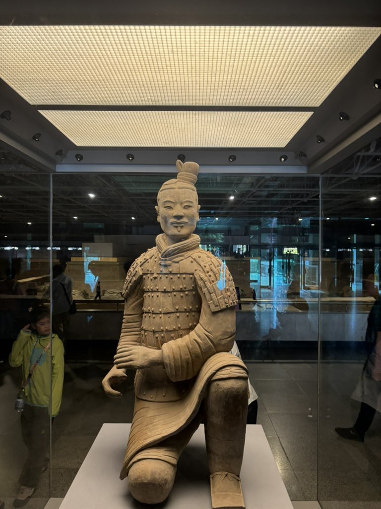
Imagine digging a well… and finding this.
That’s exactly what happened in 1974.
Farmers near Xi’an uncovered the first warriors of what became one of archaeology’s greatest discoveries.
More than 8,000 soldiers have now been identified.
And remarkably, no two faces appear to be exactly the same.
Photo credits: Me
This is Ephesus in modern Turkey.
Around 2,000 years ago it was one of the great port cities of the Roman world.
But there’s something missing today.
The sea.
Over centuries, sediment gradually pushed the coastline away and the ancient harbour became useless.
One of Rome’s great Mediterranean ports is now stranded inland.
This is Tikal, one of the great cities of the ancient Maya.
Around 2,000 years ago, its inhabitants were already filtering their drinking water.
Researchers discovered that one reservoir used layers containing quartz and zeolite, a mineral that can remove contaminants from water.
It is the oldest known use of zeolite for water purification anywhere in the world.
QUOTE: "the crux of this landmark study is the evidence that the closest genetic ties are between the two most-separated islands Hawaii and Rapa Nui (also known as Easter Island), which are each over 3,000 kilometers (nearly 2,000 miles) from the nearest inhabited island and 7,000 kilometers from each other." END QUOTE
https://t.co/4sY1LrB0Lk
🚨 1.9 Million Year Old Discovery Rewrites Human Evolution
The 'Ubeidiya site suggests humans were outside Africa 1,900,000 years ago.
This revised dating puts the site, alongside Dmanisi in Georgia, as one of the oldest known sites of early human activity outside Africa.
Imagine digging a well… and finding this.
That’s exactly what happened in 1974.
Farmers near Xi’an uncovered the first warriors of what became one of archaeology’s greatest discoveries.
More than 8,000 soldiers have now been identified.
And remarkably, no two faces appear to be exactly the same.
Photo credits: Me
These are the pyramids of Teotihuacan in Mexico.
But the Aztecs didn’t build them.
The city was already centuries old and largely abandoned when the Mexica arrived. They were so impressed by the ruins that they gave the place the name Teotihuacan which roughly means “the place where the gods were created”.
We still don’t know what the people who actually built the city called it.
This is basically the Roman version of a road map.
The Tabula Peutingeriana shows thousands of kilometres of routes stretching across the Roman world, from Britain and Spain towards India.
But if you look at the shape of it, you can see that the geography is completely distorted because accuracy wasn’t really the point. What mattered was showing roads, towns, and the distances between them.
The surviving map is medieval, but it’s believed to descend from a much older Roman original.
Someone carved every one of these symbols knowing exactly what they meant.
Now we’re staring at a message from Easter Island that nobody knows how to read.
It’s called the Aruku Kurenga tablet, covered in Easter Island’s undeciphered script.
I wonder what it says?
4,000 years ago, the Egyptians made a map of a world full of nonhuman beings.
Around 2000 BCE, the Egyptians were placing detailed maps inside coffins.
They depicted a supernatural territory known as Rosetau, described in a collection of funerary texts called the Book of Two Ways.
The maps showed two distinct routes, dangerous regions separated by fire, guarded entrances, and supernatural beings controlling passage.
Some guardians carried knives and others had animal features. Certain regions were forbidden or dangerous to enter without the proper knowledge.
The deceased supposedly needed to know the correct routes, identify the guardians, and recite specific words to gain passage.
Knowledge was the key to get in.
We're looking at a 4,000 year old document describing an organized nonhuman realm with defined routes, restricted areas, dangerous inhabitants, and conditions for gaining access.
They actually drew the bloody thing.
Egyptologists identify this as religious geography associated with the afterlife, Osiris, and the journey of the dead.
That's what the evidence supports.
I keep coming back to one question.
Why did the Egyptians envision the realm of nonhuman beings as an actual structured territory that had to be navigated? Why guarded passages and specific knowledge required for entry?
Were they constructing an elaborate religious understanding of death, drawing on familiar earthly boundaries and authority?
Or were they preserving something older that we no longer understand?
I don't know.
But I find it wild that 4,000 years ago, someone drew a map of another world.
The Battle of Trafalgar took place on October 21, 1805, off Cape Trafalgar, Spain. A British fleet of 27 ships under Vice-Admiral Horatio Nelson defeated a combined French and Spanish fleet of 33 ships led by Admiral Pierre de Villeneuve, ending Napoleon's invasion plans and securing British naval supremacy....
The defeat destroyed Napoleon Bonaparte's hopes of invading the British mainland. The battle established undisputed Royal Navy supremacy for over a century. Nelson became an immortal British national hero, commemorated by Trafalgar Square and its central column in London.
. . . . .
At dawn on October 21, 1805, the sea off Cape Trafalgar heaved with a gray and listless swell.
The wind carried the scent of powder and salt, and in the half-light the horizon was alive with motion—masts rising like a forest of pikes, sails straining, hulls creaking beneath the strain of the wind. There, the Royal Navy under Vice Admiral Horatio Nelson—outnumbered, outgunned, but unbowed—was sailing straight into the jaws of the combined French and Spanish fleet. He had chosen not caution but audacity: two narrow columns of ships cutting headlong toward the enemy line, into the very mouth of their guns.
Somewhere ahead lay destiny, and perhaps his death.
. . .
For almost a decade, Europe had trembled before one man. Napoleon Bonaparte’s armies had marched across the continent like wildfire, from Lisbon to Vienna, leaving shattered monarchies in their wake. By 1805, his power seemed limitless—except at sea. There, his dreams of empire broke upon a wall of oak and iron: the British Royal Navy. England, ringed by water and girded by ships, was the last barrier to his ambition. If he could destroy its fleet, the Channel would be open, and the legions of France could descend upon the green hills of England.
Horatio Nelson was the man chosen to stop him. A small, frail figure with one good eye and one good arm, he was no ordinary admiral. To his men, he was a living legend—a commander who led from the front, who shared their risks, and who fought as though each battle were his last. Years before, at the Nile, he had cornered and annihilated Napoleon’s fleet beneath the burning Egyptian sun. The French flagship had exploded in a fiery blossom so bright it lit the desert sky. That night, Nelson had written, “Victory is not a word strong enough.” Now, as he faced a far greater force off the coast of Spain, the stakes were higher still.
The fleets closed. Gunports yawned open along wooden hulls. Cannon crews stood by with slow matches, the air humming with the anticipation of death. At eleven o’clock, Nelson raised his telescope and gave the signal that would live forever in English memory:
“England expects that every man will do his duty.”
His men roared their answer from the decks, their voices carried away by the wind. Then the first French guns spoke. Great plumes of smoke rolled across the sea as shot smashed into the advancing British ships. Splinters flew like daggers; men were torn apart. Still, the English line came on.
Nelson’s formation defied all convention. Instead of trading broadsides in parallel lines as custom demanded, he drove his two columns directly into the enemy’s flank—Victory leading one column, Royal Sovereign the other. The maneuver was recklessly brilliance. For nearly twenty minutes, as the British ships cut the waves toward the Franco-Spanish line, they endured relentless fire, unable to answer. Masts splintered, decks flooded with blood and smoke.
Then came the shattering impact: Royal Sovereign broke through the enemy line first, unleashing her full broadside into the stern of Santa Ana at pistol-shot range, turning her decks into carnage. Minutes later, Victory smashed through between Redoutable and Bucentaure, pouring fire into both until their hulls erupted.
#archaeohistories
Make it make sense
This unfinished obelisk in Aswan was abandoned still attached to the bedrock.
If it had been completed it would have been the largest ever. The tool marks and the sheer size raise the same question every time:
how were they planning to detach and move something this heavy with the technology of the period?
dolerite pounders isn't the answer.
Imagine working on your land and accidentally uncovering a 3,000-year-old Egyptian pharaoh.
That’s what happened in Egypt’s Nile Delta, where archaeologists have discovered the remains of two colossal statues.
One depicts Ramesses II (The Pharaoh falsely thought to be part of the Exodus story).
Its head alone measures 1.6 metres, and the complete statue may once have stood 28 feet tall.
Imagine working on your land and accidentally uncovering a 3,000-year-old Egyptian pharaoh.
That’s what happened in Egypt’s Nile Delta, where archaeologists have discovered the remains of two colossal statues.
One depicts Ramesses II (The Pharaoh falsely thought to be part of the Exodus story).
Its head alone measures 1.6 metres, and the complete statue may once have stood 28 feet tall.
A Traditional Roman home :-
A traditional Roman domus was far more than a place to sleep. Its design reflected family life, social status, hospitality, and business.
The atrium welcomed visitors, while the tablinum often served as a study and a place for managing family affairs. Beyond it, the peristyle opened into a peaceful courtyard surrounded by columns, plants, and decorative features.
Dining rooms, bedrooms, kitchens, and storerooms were arranged around these central spaces, creating a home that balanced comfort with social life.
Some houses even included shops facing the street, allowing their owners to combine domestic life with commercial activity.
Ancient Roman homes were not just buildings; they were a reflection of how people lived, worked, and connected with others.
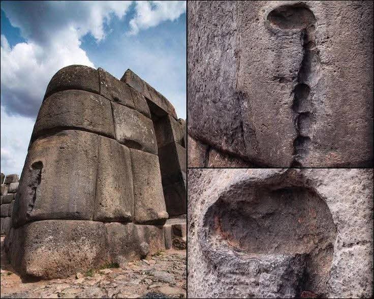
These Ancient Stones Fit Together So Perfectly That Even a Piece of Paper Can Struggle to Fit Between Them!
High in the Andes Mountains of Peru, near the ancient Inca capital of Cusco, stands a remarkable stone wall that has survived for centuries. Built during the height of the Inca Empire in the 15th century, it contains enormous blocks of stone shaped into unusual forms and fitted together with incredible precision. But here is what makes it truly fascinating: the builders used no mortar to hold these massive stones together.
Instead, each stone was carefully shaped to fit its neighbors, creating a tight interlocking structure. Some blocks have so many corners and uneven edges that they look more like giant pieces of a puzzle than ordinary building materials. And despite their irregular shapes, they fit together with astonishing accuracy.
But the mystery doesn't end there. Some stones feature strange protruding knobs and carved marks whose original purpose remains uncertain. Were they connected to the building process, used to move or handle the stones, or left for some other practical reason? Researchers have explored different explanations, but not every detail of Inca stonework is fully understood.
Perhaps the most impressive part is how these walls were built to withstand earthquakes. Rather than relying on rigid mortar, the carefully fitted stones can shift slightly when the ground shakes, helping the structure resist damage. This clever approach allowed parts of Inca masonry to survive powerful earthquakes that damaged other buildings around them.
Imagine shaping and moving stones weighing several tons without modern cranes, power tools, or heavy machinery. The Incas left behind no complete written explanation of every step of their construction methods, so many details of their remarkable craftsmanship continue to fascinate researchers today.
Standing before these ancient walls raises a remarkable question: How did the Inca builders achieve such extraordinary precision with the tools and technology available to them?
Their achievement is a powerful reminder that some of humanity's greatest engineering feats were accomplished long before the machines we depend on today ever existed.
Source: Encyclopaedia Britannica — Inca Civilization; UNESCO World Heritage Centre — City of Cusco.