🚨 Elevated Tornado Risk has been posted for TONIGHT.
Here's clip of the latest HRRR future radar, overlaying the current SPC risk map for Tornado chances.
You can also see the sleek animated drawings, now available in WeatherWise!
The surveillance state grows with every new local contract, grant, and camera that flies under the radar until there are thousands of them.
Now those cameras sit outside our schools, logging the daily movements of ordinary families. My Fourth Amendment Restoration and Protection Act would require the government to get a warrant for this type of surveillance.
https://t.co/L049CAujDe
🚨BREAKING🚨
Multiple sources confirm that President Trump has signed pardons for the following gun owners, convicted of unconstitutional "crimes" under the National Firearms Act:
- Patrick "Tate" Adamiak
- George Peterson
- Jeremy Kettler
- Shane Cox
Thank you Mr. President!
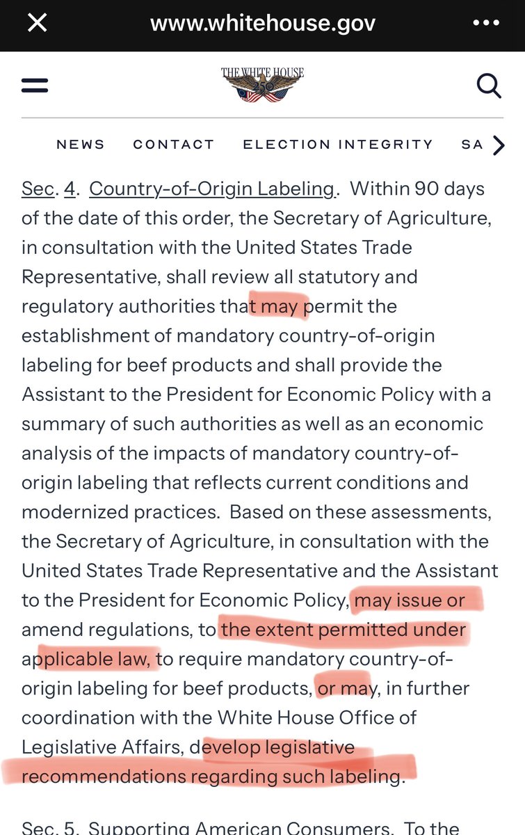
Contrary to rumors, Trump’s Executive Order issued today does NOT implement Mandatory Country of Origin Labeling for beef. They’re going to study the problem until AFTER the election, and then they MAY do something about it, IF the law allows them (it does not).
Here is a good example of why I think this Administration is losing trust with America’s farmers and ranchers.
Secretary Rollins and Ag influencers have presented today’s Executive Order as taking some meaningful action on MCOOL.
But did not restore MCOOL in any way —
Instead, it tells the USDA to spend 90 days studying whether it already has authority to require it (which it doesn’t); and then, if the law allows it (which it won’t), the USDA can act or ask Congress to act (none of which is binding on those bodies in any way).
So no, this is not MCOOL —
It guarantees a 90-day study; that I would suspect will put us right back where we are today, just 90 days later (after the election).
MAJOR ERUPTION AT ANAK KRAKATAU
Anak Krakatau is erupting in Indonesia, with satellite imagery detecting volcanic ash reaching around 48,000 ft (14.6 km).
The eruption began at 23:07 local time. Ash was moving west at around 50 knots, with the alert level at III (Siaga), meaning Alert Level 3.
Authorities are warning people to stay at least 3 km from the active crater.
I don't know what the heck is going on in the Lindsay Clancy Trial but I just witnessed the Defense and the Foreperson put a juror in the spotlight for holding on to his conviction of guilty.
11-1 and now the world knows who you are! MISTRIAL!!!
@nataliegwinters Didn't Nikki Haley give China acreage within walking distance to a military facility? 3.5M acres of US agricultural land is owned by foreign entities, 1.5M acres is owned by Canada, WHY? Not one grain of American soil should be owned by anyone other than an American, not one!
Tropical Storm Warnings just went up for Texas and Louisiana.
And landfall is tomorrow.
That’s basically ONE day of warning.
This thing is still just off Louisiana, and it could become Tropical Storm Edouard tonight.
Probably not a monster.
But parts of Texas could get up to 9 inches of rain.
🚨 Remember, we said to keep an eye on the Gulf?
Well now, there's a cone and there's the expectation of at least a Tropical Storm (AL97), heading into Southern Louisiana and Texas.
We have ALL KINDS of information for you to see in the WeatherWise app, from Hurricane Hunter Data (turn on aviation in the burger menu), to Spaghetti Tracks and National Hurricane Center information (click on the cone and select the arrow for all NHC info).
🚀 Official European weather alerts & satellites have arrived!
⚠️ Official alerts for 39 European countries, issued by each country's national weather service (DWD, Mét��o-France, the UK Met Office and more). All 14 official alert types using MeteoAlarm's official awareness colors on the map.
🛰️ New satellites: near-realtime Meteosat-12, Meteosat-9 (Indian Ocean) and Meteosat-11 Rapid Scan imagery, plus the Metop polar orbiters. Italy's national radar composite (DPC) too.
✅ The new European alerts and satellite imagery are completely FREE, no subscription required.
Also in this update:
🧊 3D Satellite: 23 derived GOES products now render in 3D (Plus/Pro)
📡 New US research radars: FUSA (Denton, MD) with a full volume roughly every minute, MZZU (Columbia, MO), and GAWX now scanning 8 tilts
🚨 A redesigned alert view: key facts at a glance, tap-to-change units, and a new Flash Flood Warning "considerable damage threat" intensity level setting
Something potentially historic is unfolding across the tropical Pacific. (Worth the READ):
The ECMWF SEAS5 seasonal model projects sea-surface temperatures running locally near 10°F above normal by December. It is one of several models suggesting the developing El Niño could become the strongest of the modern era and potentially rival or surpass the legendary 1877–78 event.
NOAA now gives El Niño a greater than 90% chance of becoming very strong this fall and winter. There is also a 69% chance it exceeds every El Niño in NOAA’s official record dating to 1950.
If forecasts of this magnitude verify, the effects could extend well beyond the Pacific:
• A stronger and more active southern storm track could bring frequent storms, heavy rain and flooding to parts of California, the Southwest, Gulf Coast and Southeast this winter.
• The northern United States and southern Canada could experience an unusually mild winter overall, while the Ohio and Tennessee valleys historically lean warmer and drier during El Niño.
• Parts of the southern United States could face an increased risk of cool-season severe weather when strong storm systems draw warm, humid air northward from the Gulf.
• Internationally, extreme rainfall and flooding could affect western South America and East Africa, while drought, extreme heat and wildfire conditions become more likely across Australia, Indonesia, southern Africa and other vulnerable regions.
• Agricultural disruptions could grow as major crop-producing regions experience sharply different rainfall patterns, potentially affecting food production and prices.
• El Niño’s influence on global temperatures is often strongest during the year after it develops. That means 2027 could bring exceptional global warmth, intensifying heat waves, marine heat waves and coral bleaching.
• If El Niño remains influential through the summer of 2027, increased wind shear could suppress Atlantic hurricane activity while creating more favorable conditions across the eastern and central Pacific.
None of these outcomes is guaranteed, and even historically powerful El Niño events do not affect every region the same way. However, the growing agreement between seasonal models and official agencies makes this one of the most important developing climate signals in years.


![Laura3930's tweet photo. [ A very interesting read of the Fiction-Babble; By the Majority-Leader STEVE SCALISE. ] https://t.co/hxJ5EsMhFk](https://pbs.twimg.com/media/HSLvf5na8AAhcF1.jpg)
![Laura3930's tweet photo. [ A very interesting read of the Fiction-Babble; By the Majority-Leader STEVE SCALISE. ] https://t.co/hxJ5EsMhFk](https://pbs.twimg.com/media/HSLvf5EW8AA0YIz.jpg)
![Laura3930's tweet photo. [ A very interesting read of the Fiction-Babble; By the Majority-Leader STEVE SCALISE. ] https://t.co/hxJ5EsMhFk](https://pbs.twimg.com/media/HSLvf5CXkAAwyJ7.jpg)







![Laura3930's tweet photo. [ A very interesting read of the Fiction-Babble; By the Majority-Leader STEVE SCALISE. ] https://t.co/hxJ5EsMhFk](https://pbs.twimg.com/media/HSLvf5nbsAArsPl.jpg)