4am ET:
~ Storms will begin to blossom soon near Evansville IN. This cluster will merge with the already existing line and move East. See our previous post for forecast details.
#WNK#KYWX#WX#Kentucky
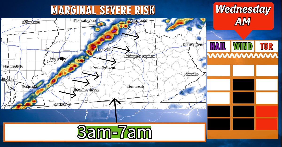
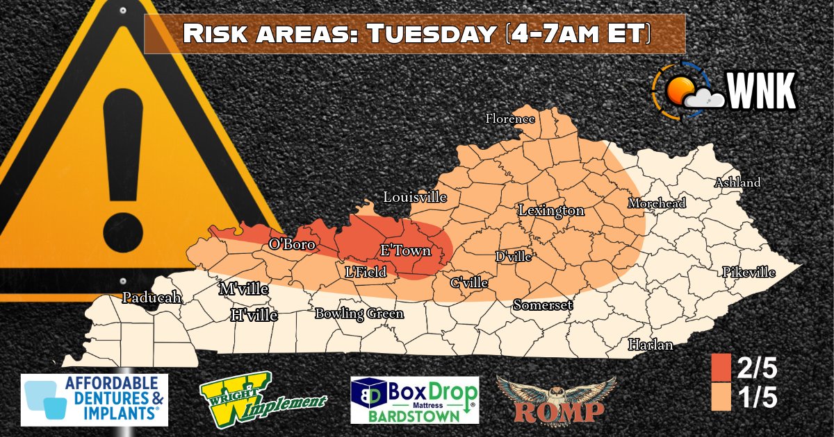
Alert window, 4-7am ET:
~ A small cluster of storms will dive from Indiana into Kentucky in a few hours.
~ Main Risks: Hail (some isolated pockets of large hail), brief bursts of damaging winds (60+mph), and while odds are low, a small tornado risk exists within the orange zone.
~ Orange: Higher risk of seeing the above mentioned severe modes.
~ Tan: Lower risk of seeing the above mentioned severe modes (tornado risk is 0).
~ White: Thundershowers may move through, but aren't currently expected to meet severe levels. - George
#KYWX #WX #Kentucky #WNK
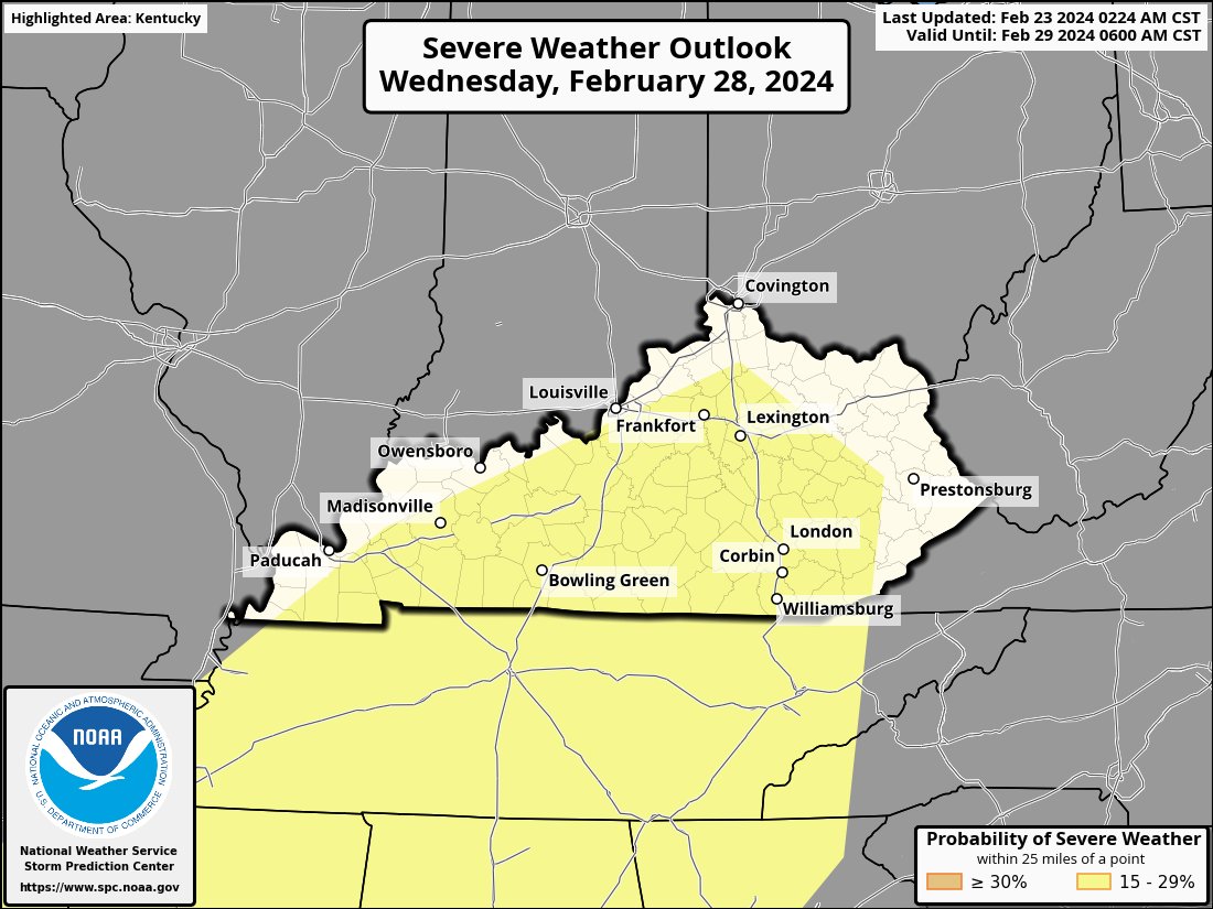
Just in:
~ Day 1 outlook has been updated by the NWS and it includes a slight risk of severe weather for the Northern half of the state and a marginal risk for the Southern half. This is right on par with out thinking.
~ Generally 2 main windows for strong weather: Tuesday AM (3-6am ET) Tuesday night/Wednesday AM (11pm-7am ET).
~ As always, we will be up for the next 30 hours and will post many updates + go LIVE if any impending concerns arise. - George
#WNK #KYWX #WX #Kentucky
First round starts at 3am ET. Remember, we're expecting more strong weather Wednesday morning too. Check our previous posts for more information.
#WNK#KyWX#WX#Kentucky
Join us on our LIVE Broadcast near 8pm ET. We'll be streaming to both YouTube and Facebook. Tonight's broadcast is regarding the impending severe threat Tuesday morning & Wednesday morning. - George
#WNK#KYWX#WX#Kentucky
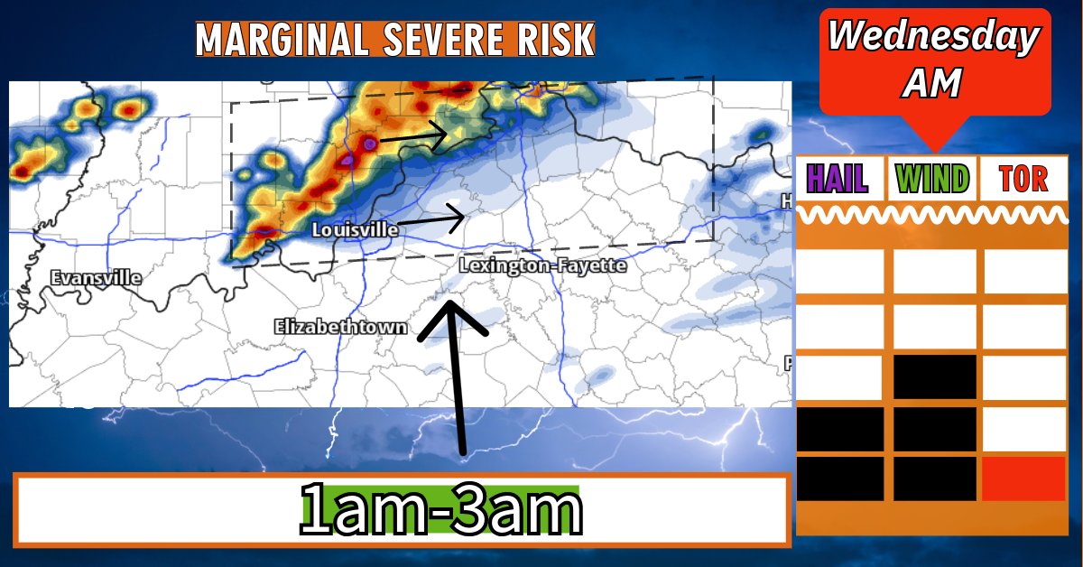
3 different batches of storms carrying varying risks beginning Tuesday morning and ending Wednesday morning, read:
~ Tuesday 3-7am ET: Large hail is the main risk here, mainly North of the parkways. Periodical wind gusts of 60+mph may occur too. Tornado risk near 0.
~ Wednesday 1-3am ET: Storm energy will be closer to the surface, this will lead to a slightly higher isolated tornado/severe wind risk. Hail threat is there too, but hail size should be smaller. The tornado threat is low, but not zero.
~ Wednesday 3-7am ET: Storms will form in more of a line, this will lead to a QLCS event with embedded rotation. This type of line of storms typically result in a thin line of enhanced wind gusts, small hail and a low end spin up risk. Increased levels of surface storm juice may lead to a couple spin up tornados but the odds are low.
~ More details tonight in our LIVE Broadcast on both Youtube and Facebook near 8:30pm ET. - George
#WNK #KYWX #WX #Kentucky
Data coming in this morning/afternoon raises some concerns for severe weather for portions of Kentucky. Look for a detailed forecast breakdown shortly and we'll be doing a Live Outlook broadcast this evening near 8pm ET. - George
#KYWX#WX#Kentucky#WNK
@Kentucky_WX Genuine question:
- If we know a models over bias, why would we ever publish posts including tainted information? To the naked eye that looks like a dangerous line of storms. When over 90% of the time the RRFS is way over bullish. Genuinely curious...
Buddy we were cheeks for 3-4 years and still have 20 more wins than UK since 2010. Lmao!
I've been tryna tell my boys to enjoy their up time. Daddy comes back soon.
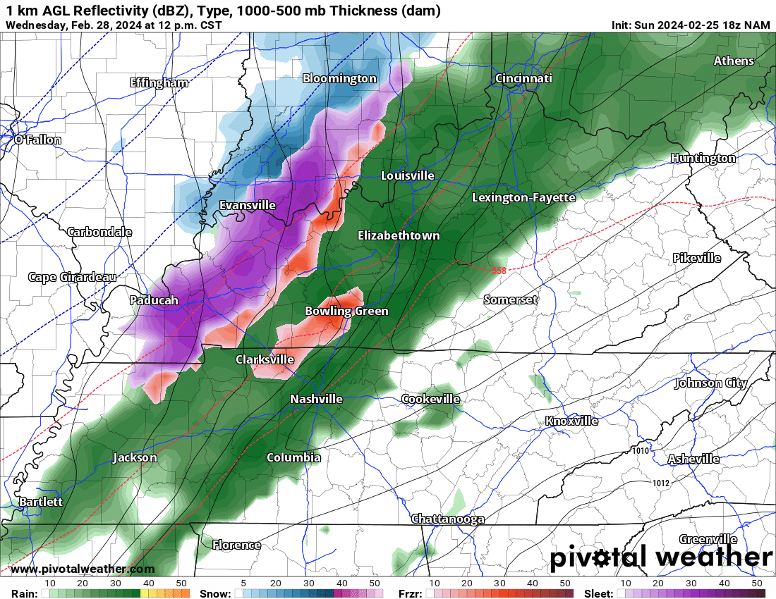
70+ degrees Monday to a potential sleet storm Wednesday... There's going to be a lot of confused Kentuckians over the next 72 hours. - George
#KYWX#WX#Kentucky#WNK
Model data has been so horrendous with this setup that in 24 hours we've gone from a severe weather threat, to a thunderstorm/SLEET setup. I hoped to have more forecast details for you tonight, regarding Wednesday. However, it's just too inconsistent at the moment. - George
#kywx #wx #kentucky #wnk
Going through new data for Tuesday/Wednesday, lord help me. There isn't enough coffee in this house for this image. Strong thunderstorms and then... snow? Forecast details will hopefully be ready today. - George
#WNK#KYWX#WX#Kentucky
@JMOinKY@tornadorology Very simple solution. Stop looking beyond 3-4 days out. It's their job to highlight potential risks. We all know the guidance can easily change. They had more than enough credible info to roll with that 3 days ago. They've done the smart thing now and backed off. Smart.
Ban court storming, but I'll also say, this still looks like Kyle initiating contact. But again, a player shouldn't be in this position. Let the opposing team have the opportunity to leave the court.
Temperatures climb QUICKLY on Sunday after a frozen start. Paducah area will make a run at the upper 60's! Soak up the sunshine, friends.
#WNK#KYWX#WX#Kentucky
Your Saturday in Kentucky will feel quite cold after a the warm spell we've been in. A few rain showers/ brief snow flurries (in far NE KY only) may occur in the very early morning hours.
#WNK#KYWX#WX#Kentucky
Confidence is increasing in a multi day thunderstorm setup for early next week. Finer details are still a bit cloudy for now. We hope to be able to gain more clarity Saturday evening for you.
#WNK#KYWX#WX#Kentucky