Missed the webinar? The recording is now available.
Learn how Landsat Special Requests allow researchers to request non-routine imagery acquisitions for unique science applications, including nighttime urban heat studies and polar ice monitoring.
The webinar also walks through how to submit a request and what to expect during the review process.
📷 Watch here: https://t.co/DGgjbLA2T9
You must be wondering why Donald Trump, after all the tough talk, quietly stepped back and offered an indefinite pause on military escalation with Iran. No grand announcement. No victory speech. Just a sudden, unusual stillness.
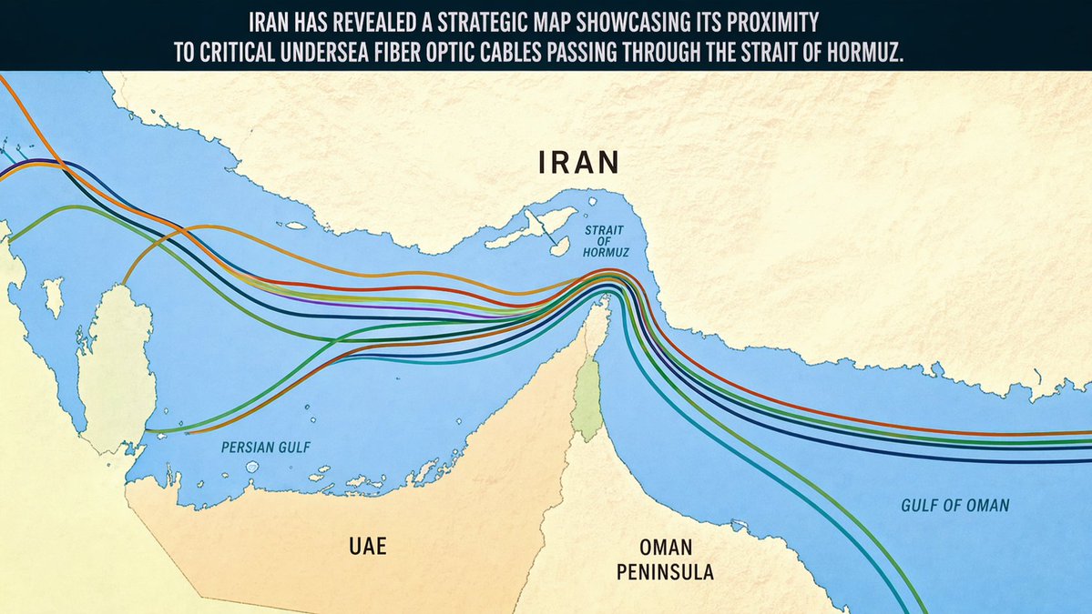
Iran sent him a map.
Not a peace proposal. Not a diplomatic note. 𝐀 𝐬𝐭𝐫𝐚𝐭𝐞𝐠𝐢𝐜 𝐦𝐚𝐩 𝐬𝐡𝐨𝐰𝐢𝐧𝐠 𝐞𝐱𝐚𝐜𝐭𝐥𝐲 𝐰𝐡𝐞𝐫𝐞 𝐢𝐭 𝐬𝐢𝐭𝐬 𝐢𝐧 𝐫𝐞𝐥𝐚𝐭𝐢𝐨𝐧 𝐭𝐨 𝐭𝐡𝐞 𝐮𝐧𝐝𝐞𝐫𝐬𝐞𝐚 𝐟𝐢𝐛𝐞𝐫 𝐨𝐩𝐭𝐢𝐜 𝐜𝐚𝐛𝐥𝐞𝐬 𝐩𝐚𝐬𝐬𝐢𝐧𝐠 𝐭𝐡𝐫𝐨𝐮𝐠𝐡 𝐭𝐡𝐞 𝐒𝐭𝐫𝐚𝐢𝐭 𝐨𝐟 𝐇𝐨𝐫𝐦𝐮𝐳.
That map said more than a thousand missiles ever could.
The Strait of Hormuz is a narrow waterway between Iran and the Arabian Peninsula. The world already knew it carries nearly 20% of global oil. What fewer people talk about is that the same narrow passage is threaded with undersea cables that carry the internet, banking data, and financial transactions for hundreds of millions of people across the Middle East, Asia, and beyond.
𝑻𝒉𝒊𝒏𝒌 𝒂𝒃𝒐𝒖𝒕 𝒘𝒉𝒂𝒕 𝒕𝒉𝒂𝒕 𝒎𝒆𝒂𝒏𝒔 𝒇𝒐𝒓 𝒂 𝒎𝒐𝒎𝒆𝒏𝒕.
Your salary transfer. Your business payment. Your hospital billing system. Your supply chain software. All of it travels as pulses of light through cables thinner than a human hair, resting silently on the ocean floor. If those cables are cut, the damage is not just technological. Businesses collapse overnight. Banking systems freeze. Economies bleed while the world waits weeks for underwater repair ships to even locate where the break occurred.
𝐓𝐡𝐢𝐬 𝐢𝐬 𝐰𝐡𝐲 𝐧𝐨 𝐫𝐨𝐜𝐤𝐞𝐭 𝐥𝐚𝐮𝐧𝐜𝐡𝐞𝐫 𝐬𝐜𝐚𝐫𝐞𝐝 𝐓𝐫𝐮𝐦𝐩. 𝐀 𝐦𝐚𝐩 𝐝𝐢𝐝.
Because a map of chokepoints tells you something a weapon cannot. It tells you how much the other side is willing to lose, and more importantly, how much you are. The United States and its allies have built their entire economic architecture on this invisible underwater infrastructure. Disrupting it would not hurt Iran half as much as it would hurt global markets, Western banks, and the digital economy that the modern world depends on.
Iran did not threaten war. It reminded the world of its geography.
There is something deeply human in this moment, and also deeply sobering. We built a globalized civilization on thin wires buried under oceans, and we never really asked who sits above them. Now we know.
𝑻𝒉𝒆 𝒎𝒐𝒔𝒕 𝒑𝒐𝒘𝒆𝒓𝒇𝒖𝒍 𝒏𝒆𝒈𝒐𝒕𝒊𝒂𝒕𝒊𝒏𝒈 𝒕𝒐𝒐𝒍 𝒊𝒏 𝒕𝒉𝒆 𝒘𝒐𝒓𝒍𝒅 𝒊𝒔 𝒏𝒐𝒕 𝒂𝒍𝒘𝒂𝒚𝒔 𝒂 𝒃𝒐𝒎𝒃. 𝑺𝒐𝒎𝒆𝒕𝒊𝒎𝒆𝒔 𝒊𝒕 𝒊𝒔 𝒂 𝒎𝒂𝒑.
𝐒𝐮𝐤𝐡 𝐒𝐚𝐧𝐝𝐡𝐮
Director, CAQA | Editor-in-Chief | ISO Auditor | Poet and Writer
Forbes Business Council Member | United Nations Speaker
Top 100 Global Educator | RTO/AI/HE/ISO Expert
Global Advisory Board Member, Forttuna Education Council
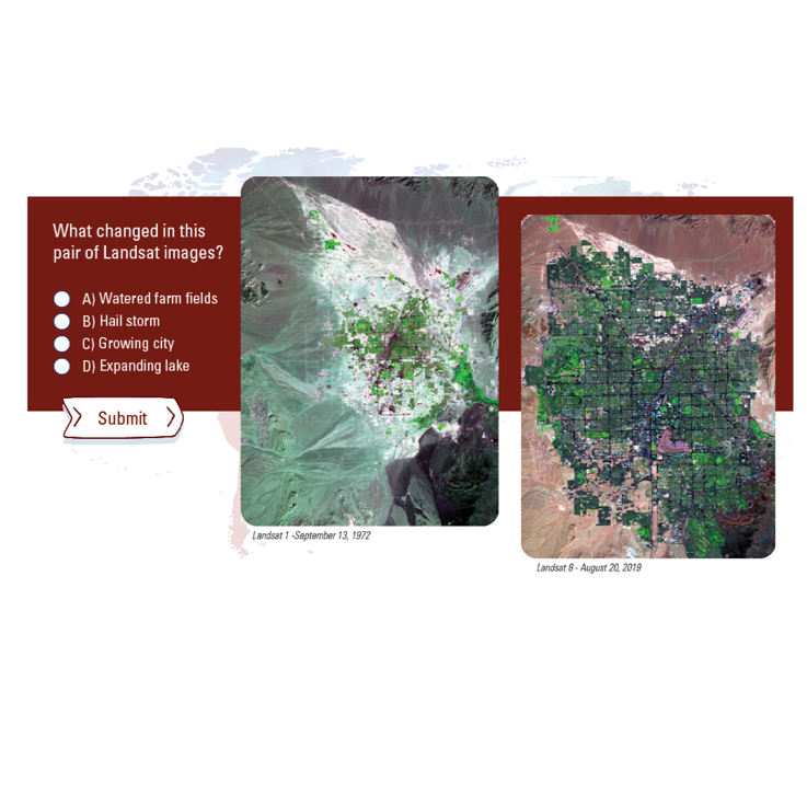
Ever wondered how fast a city can grow in the desert? 🏜️
From 🛰️Landsat’s view 438 miles above Earth, watching Las Vegas, Nevada expand is a masterclass in landscape change.
The growth of the Las Vegas metro area can easily be seen in these images from 1986 to 2025. Arid land has been transformed into urban space, with varying shades of green. Roads are indicated by dark lines as they make their way through the dense urbanized strip leading north from the airport. The 2025 image highlights the vibrant green pathways of the many golf courses in the area.
For over 53 years, Landsat satellites have been capturing images of Earth's land masses. Along with Las Vegas, the USGS Earthshots webpage contains images of change for more than 100 locations around the world. You can explore them all here: https://t.co/CzRAEsqdSD.
📷 1986: Landsat 5 image of the Las Vegas metro area when the estimated population was 600,000.
📷 2025: Landsat 9 image showing the Las Vegas metro area now home to 3 million residents.
#EarthFromSpace #RemoteSensing #SatelliteImagery
TWEEPS: The Republicans control the House, the Senate, and the White House. If there is a government shutdown, then THEY OWN IT.
Can we get 1,000 fast RTs and replies with the hashtag #ThisIsTrumpsShutdown to get it trending on Twitter?
Please and thank you. 🙏 💪🏽
The work of the USGS Land Change Monitoring, Assessment, and Projection (LCMAP) initiative datasets use Landsat information to follow land cover and change story of every pixel in the conterminous United States from 1985 on.
🛰️Every pixel tells a story.
That’s because a Landsat pixel is more than a speck of satellite data. It’s a piece of ground on planet Earth.
Check out our stories showing how #Landsat imagery shows land cover change.
https://t.co/6lpIRo967D
@USGS_EROS#landcover
The interactive USGS "How Do You Landsat” experience has been recently updated! When the USGS 'opened' the #Landsat archive in 2008, it provided regional and global projects the opportunity to utilize Landsat data.
Check out #HDYL here: https://t.co/PP1BFKqF57.
#Landsat celebrates National #STEM/STEAM Day every day!
Do you have an eye for land cover change? Test your ability to spot changes on the Earth's surface with this Land Change Quiz: https://t.co/dv354YuOoB.
Two summers ago, a new neighbor of ours….who just assumed we were Trump supporters…was doing the typical “chat across the fence” thing that happens when two people happen to be in their yard and near the fence line at the same time.
We had some surface level chat about the housing market, etc….since he had just bought a house. He then took a swerve to the border. “Man, if we don’t get these Mexicans flooding across the border shut down…this country will be all screwed to hell.”
I asked, “Hey. Who roofed your fucking house last week? Looked like a hispanic crew to me. I didn’t see one person who looked like white. Know why? (We lived in a depressed economic rural setting) I’ll tell you why. Because every Goddamn white, high school drop out around here…is on social media bitching about not being able to make $40 fucking dollars an hour for doing NOTHING.”
He looked intimidated. I was comfortable with that.
I don’t know about where you live, but for the last twenty-years…in my area…I’ve watched immigrants happily doing hard jobs for a solid livable wage, and showing up to work on time every day of the week.
When it comes to hard, strenuous jobs….where you actually have to bust your ass all day long, the immigrants are the ones getting a lot of it done.
The neighbor hasn’t tried to speak to me again. That’s probably best.
I watched our weekly postings of who has been thrown in our county jail. There’s almost never an immigrant in our jail. It is flooded with repeat Meth addicts for stealing, domestic abuse, or assault charges of some kind.
I know one thing; I never see the people who are on in and out of our jail….on the roof of a house on a miserably scorching mid-July day making some Trump supporting asshole happy that they didn’t have to roof their own house. Never.
This animation shows the darkened area north of Corpus Christi, Texas, captured by #Landsat 8 during the solar eclipse on 14 Oct 2023. The affected path (and neighboring, captured at different times) show the contrast in visible and infrared imagery.