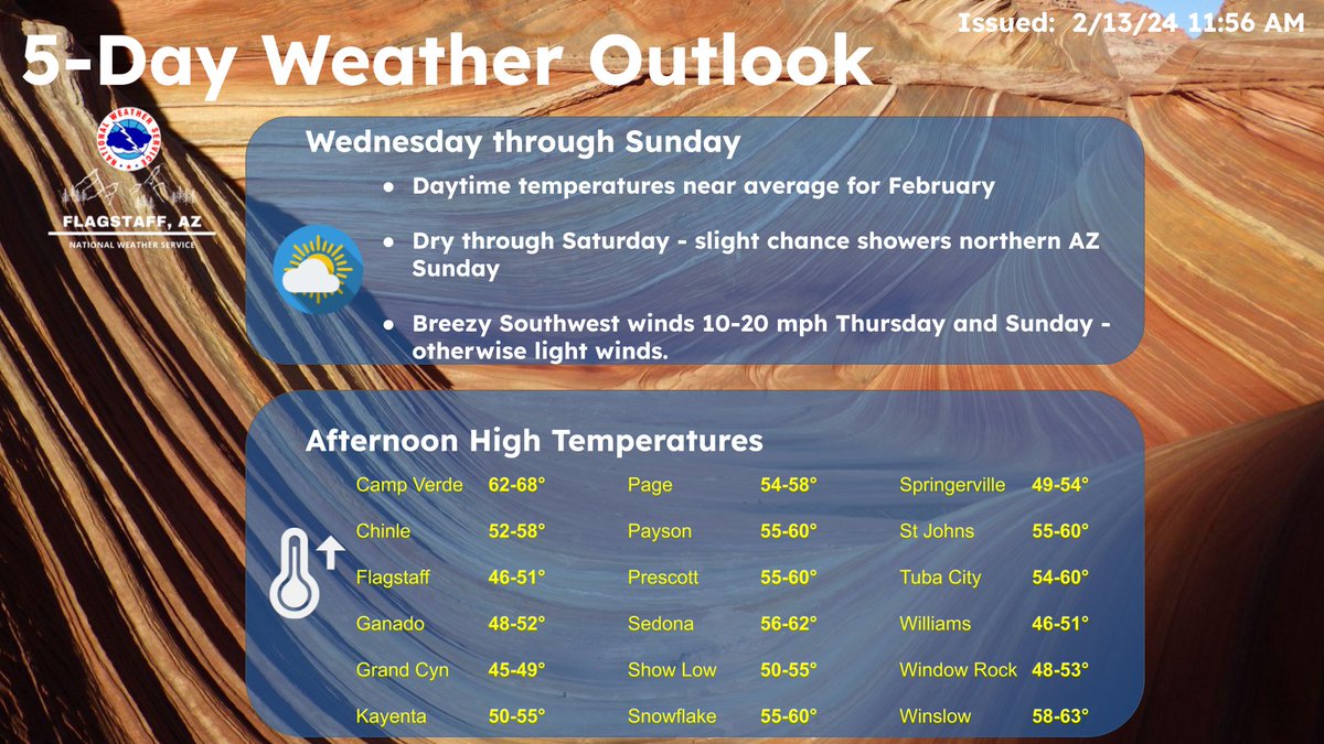
Mild daytime temperatures and mostly dry weather is expected through the weekend, with just a slight chance of showers in far northern Arizona on Sunday. Breezy southwest winds arrive on Thursday and again Sunday, with otherwise light winds are expected. #azwx
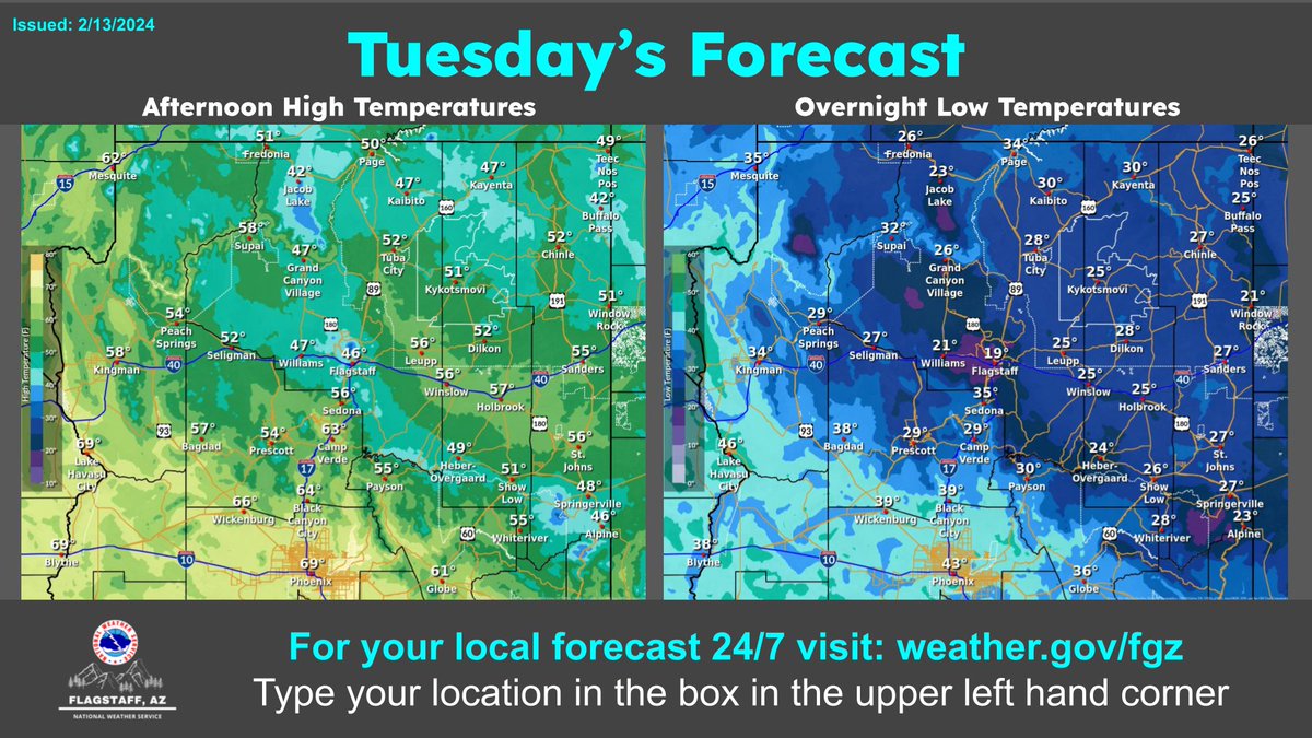
Mostly sunny skies are in store for Tuesday, with clear skies tonight. Temperatures today will warm to around normal, chilly again tonight, but not as cold as recent nights. #azwx
This is a water vapor loop showing a strong area of low pressure off the West Coast and high clouds moving over northern Arizona Friday evening. Cooler weather and a chance for showers and high elevation snow will last well into next week. #azwx
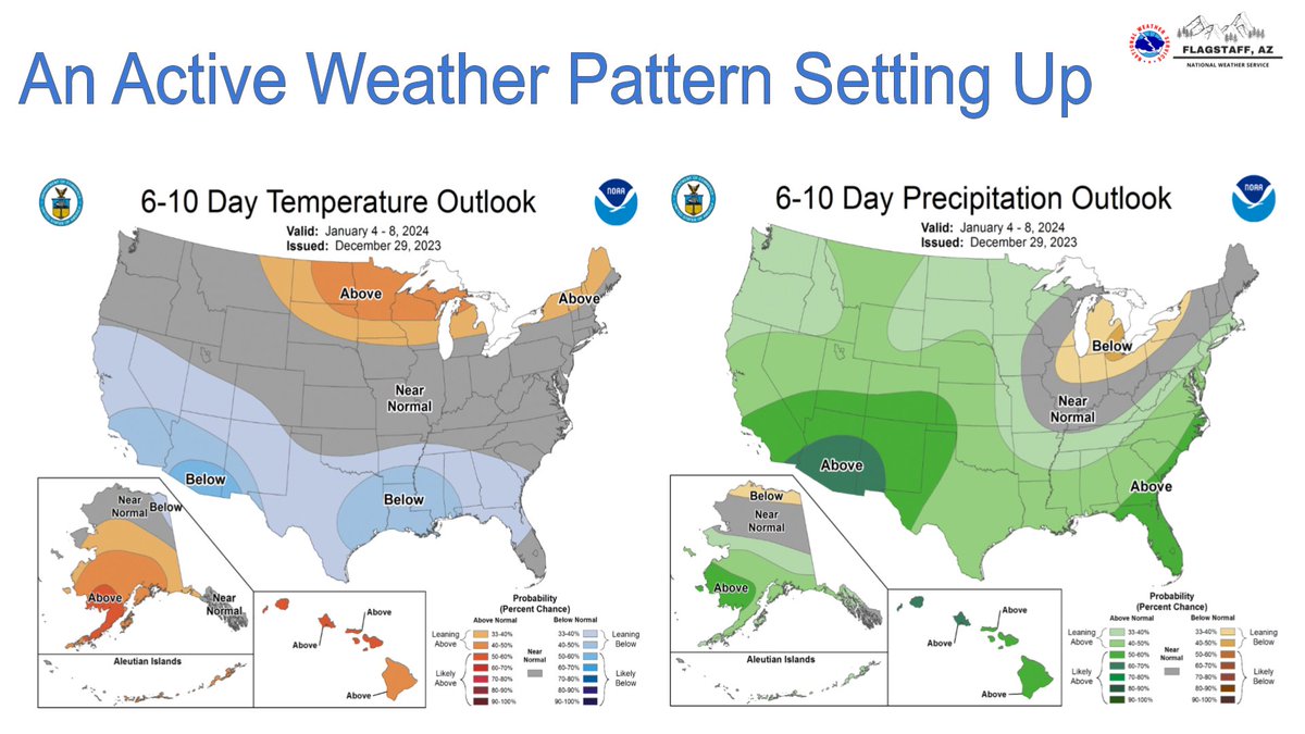
The pleasant but boring weather is coming to an end for AZ. It may take a few days but an active weather pattern will ramp-up thru the week leading to a decent chance of widespread rain and snow showers by Thursday and Friday. Go to https://t.co/S8qlkpVjBU for more info. #azwx
Roller coaster drop ahead! 🎢While temperatures have been running above normal recently, an upcoming weather system is going to drop our temperatures Saturday several degrees below normal. #azwx
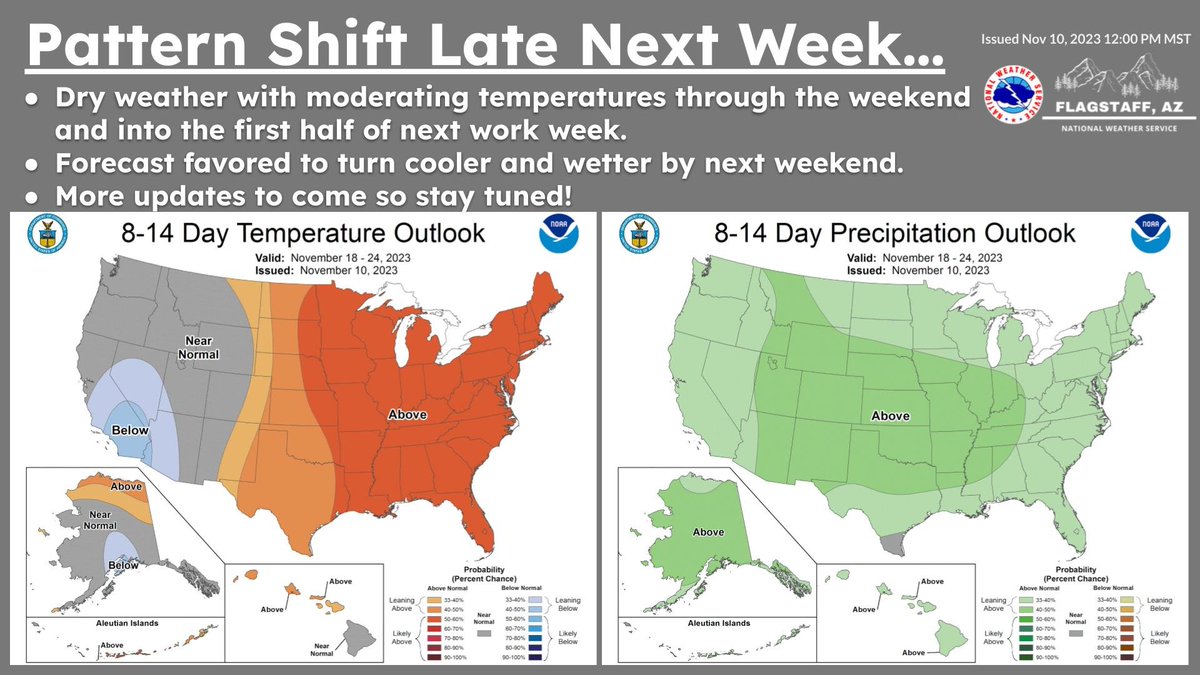
While conditions remain dry and warm over the weekend into the first half of next week, cooler weather will return by next weekend. At the same time, the forecast is favored to turn wetter. We are monitoring this period of the forecast closely so stay tuned for updates! #azwx
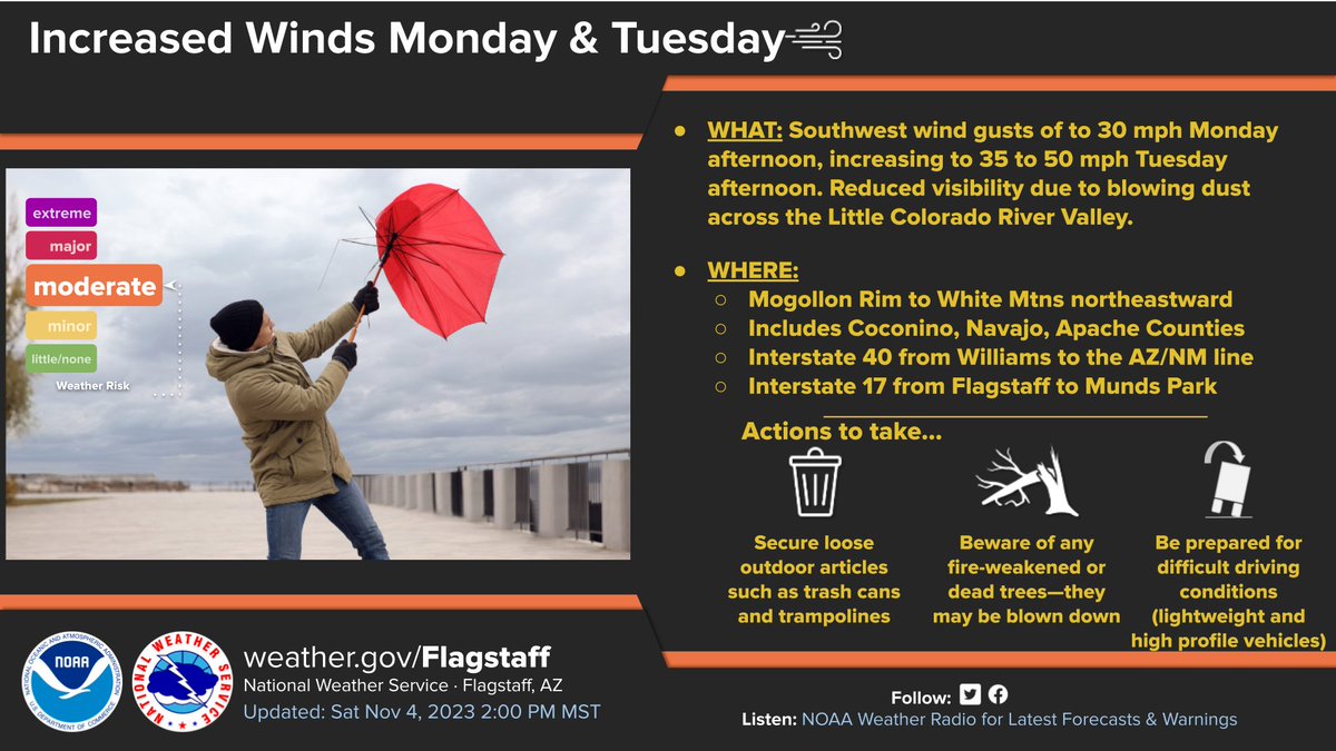
Pleasant conditions will continue through Sunday with the wind machine cranking up on Monday and especially Tuesday across the AZ High Country. Southwest wind gusts between 35 and 50 mph are forecast early next week. Check back for details! #azwx
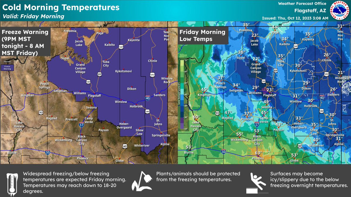
Are you ready for the coldest night of the season so far? Freezing weather is still on tap for much of the Colorado Plateau. This includes locations along and north of the Mogollon Rim. Take care! 🥶 #azwx
Many areas are in the 30s and 40s across northern Arizona this morning. Despite the cold start to today, tomorrow (Friday) morning is forecast to be even colder! As a result of the widespread freezing/below freezing temperatures, we have issued a Freeze Warning for much of N. AZ.
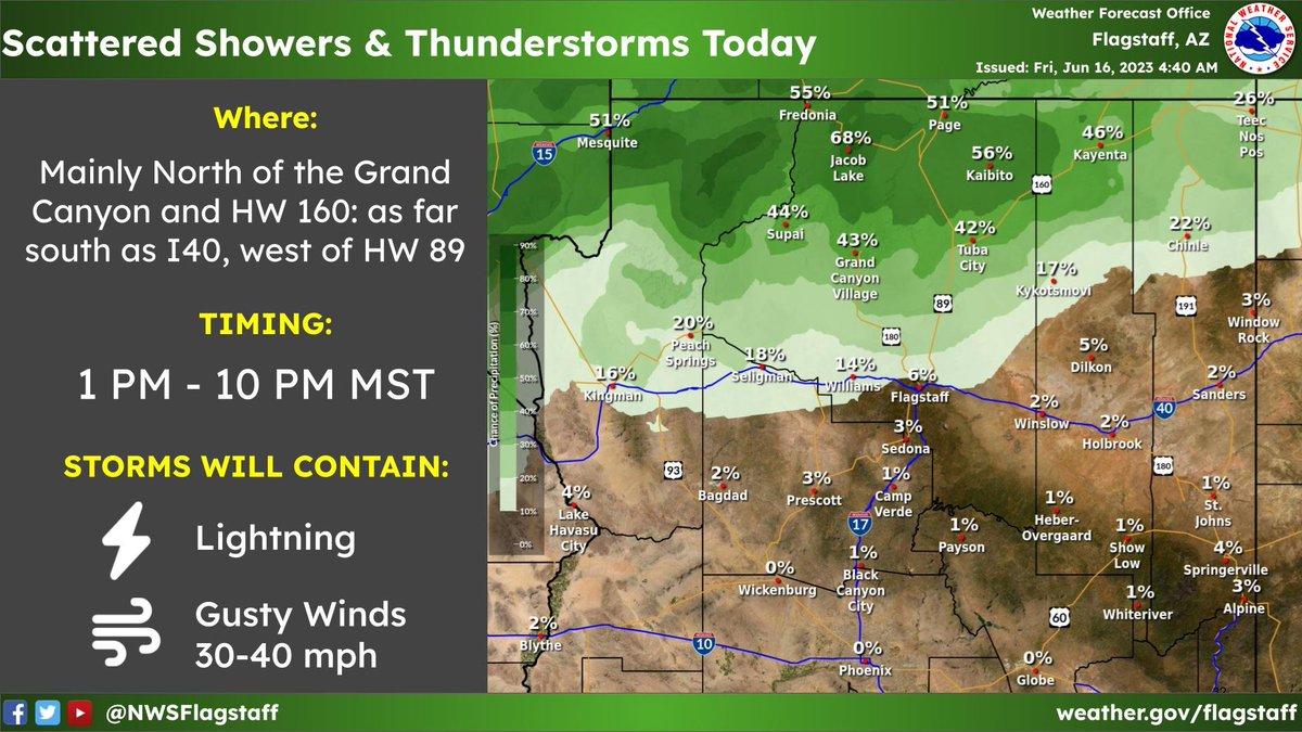
Scattered showers and thunderstorms develop this afternoon and evening in northern Arizona, mainly north of the Grand Canyon and HW 160, but could develop as far south as I40, west of HW 89. Gusty winds 30-40 mph and lightning will be the main threats with these storms. #azwx
Increased winds, warm temps, and dry conditions will result in elevated fire weather conditions today mainly for the White Mountains and then most of Northern Arizona Sunday and Monday. Make sure you are staying up to date on any changing fire restrictions in your area. #azwx
1015 AM MST Update: Showers and isolated t-storms are already developing over the higher terrain, moving northward. Showers increase in coverage through the afternoon, highest in Coconino County. Gusty wind & lightning the main threat. #azwx
@ReedTimmerAccu You can thank Super Typhoon #Mawar for this unusually strong jet streak, which dumped a lot of westerly momentum onto the Pacific jet ~12 days earlier.
The storm threat continues today generally of the isolated variety. The main activity will be located from near Flagstaff northwestward to the Grand Canyon. Otherwise, look for little change in high temperatures with light winds and partly cloudy skies. #azwx
We're usually posting about fire danger this time of year - not this week! Rain/thunderstorm chances continue today across northern AZ.
The beneficial moisture will continue to delay fire season [see latest Fire Danger Map] --> so much green! #azwx


![NWSFlagstaff's tweet photo. We're usually posting about fire danger this time of year - not this week! Rain/thunderstorm chances continue today across northern AZ.
The beneficial moisture will continue to delay fire season [see latest Fire Danger Map] --> so much green! #azwx https://t.co/QoM9zow9Cy](https://pbs.twimg.com/media/FwkcRiqaIAYX_kY.jpg)












![NWSFlagstaff's tweet photo. We're usually posting about fire danger this time of year - not this week! Rain/thunderstorm chances continue today across northern AZ.
The beneficial moisture will continue to delay fire season [see latest Fire Danger Map] --> so much green! #azwx https://t.co/QoM9zow9Cy](https://pbs.twimg.com/media/FwkcSWFaYAUqvoP.png)


