JACK FOR CHIEF!
Kid’s brilliant, tells you what you need to know
- “Watch your heads” ✅
- “Get smarter” ✅
- “Throw sunglasses in the trash” ✅
This is top-flight meteorologin’ 🤌
FIRST THE FURNACE. THEN WE TURN ON THE CANADIAN AIR CONDITIONER
KC Update Friday 7/17/26
- New info is coming in for next week, and I like what I see
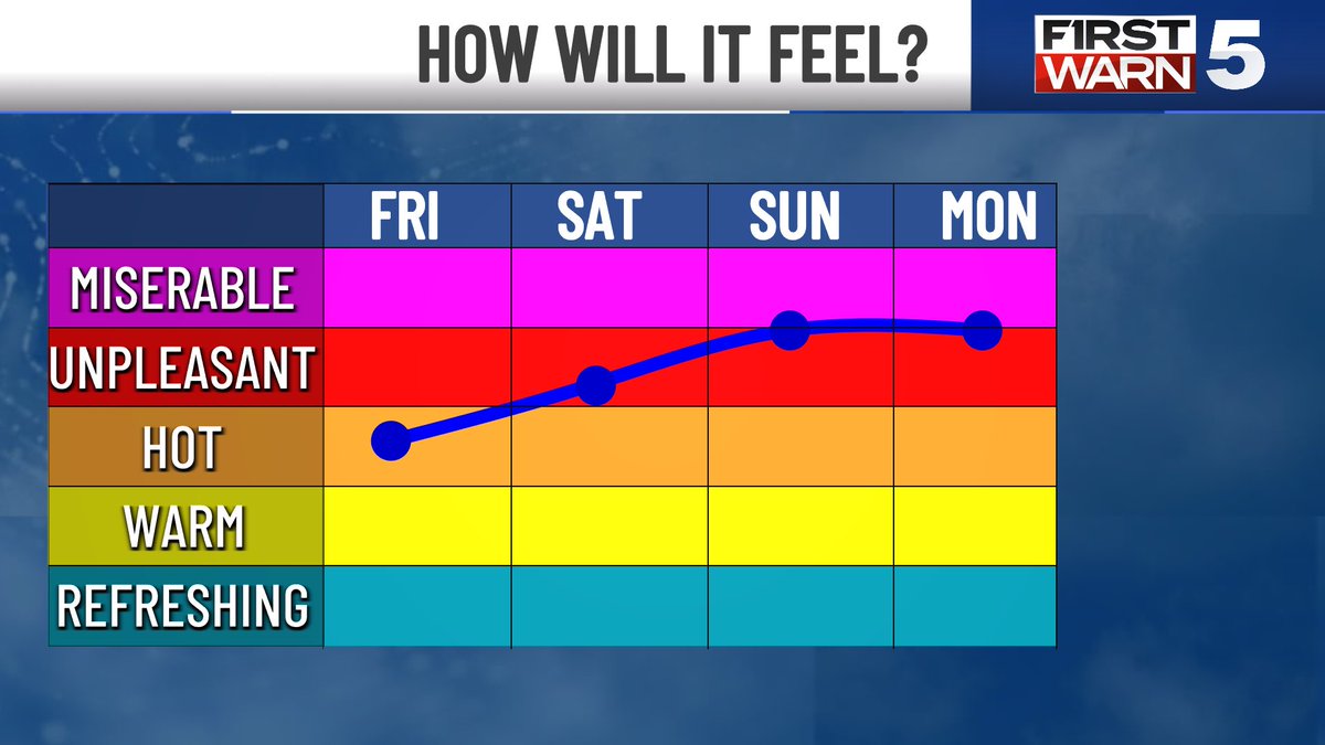
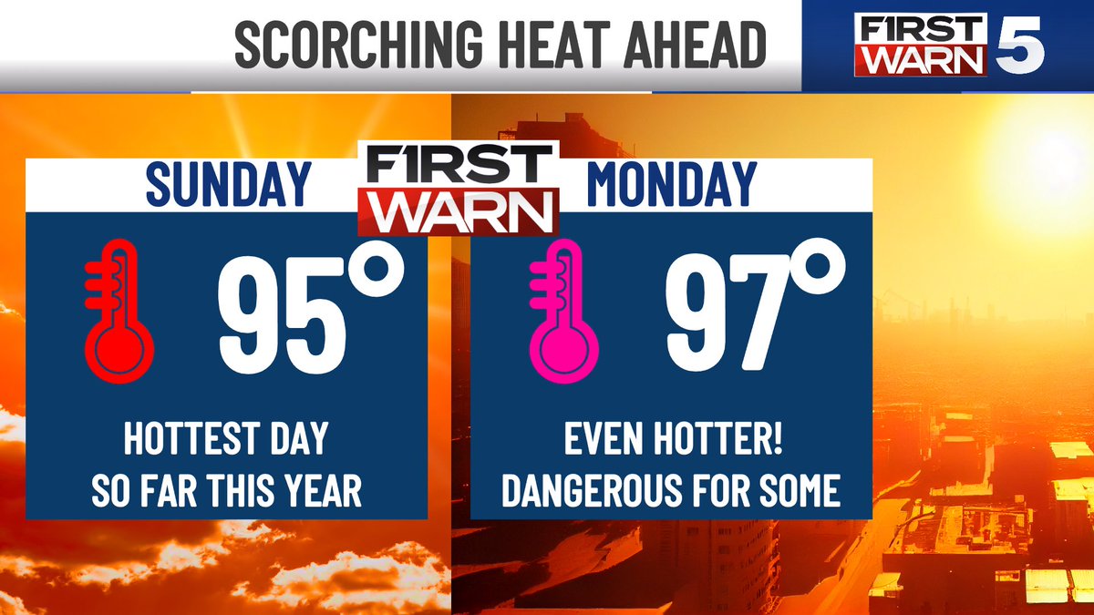
- First, we cook. Sunday and Monday are the worst of it. Nasty heat, even by July standards
- Front arrives Tuesday, knocking humidity out and dropping us to cooler than normal by mid-week
- It may feel 35 degrees cooler Wednesday compared to Sunday
- Not chiseled in stone, but we hope it holds the line
#kcwx #kswx #mowx
MAJOR SATELLITE OUTAGE 🛰️⚠️ The GOES-19 satellite, used for tracking hurricanes in the Atlantic, is out until further notice according to NOAA. The satellite monitors the eastern United States, Atlantic Ocean, Caribbean, and Gulf.
The outage affects everything from visible and infrared satellite imagery to lightning detection and hurricane analysis products. While this is a major issue, it does not mean weather forecasting or hurricane forecasting stops. Meteorologists still have radar, weather balloons, surface observations, aircraft reconnaissance, weather models, and other satellites available.
NOAA has not yet announced what caused the problem or how long repairs may take. The good news is that NOAA designed the satellite system with redundancy, including a backup satellite that could potentially be brought online if needed. I'll keep you updated when things return to normal (hopefully soon).
- Matt Devitt Weather
FROM DOWNPOURS TO DOG DAYS
KC Update Thursday 7/16/26
- Scattered slow moving downpours this afternoon bring the best rain chance in the entire forecast
- Eyes then turn to increasing heat into the weekend
- Sunday looks to be the hottest day so far this year
- It is immediately dethroned by Monday’s scorcher
- Moderate humidity brings the heat index to near 105 each of those days
- Cool front arrives Tuesday… but it may not arrive until Tuesday evening. Regardless, the heat looks to break by the middle of next week
#kcwx #kswx #mowx
815 AM: Flash flood EMERGENCIES remain in effect for parts of Uvalde county including Uvalde & Knippa, & Kerr & Kendall counties including Kerrville, Ingram, Hunt, Comfort, & Sisterdale. THIS IS A PARTICULARLY DANGEROUS SITUATION! MOVE TO HIGHER GROUND NOW!!
A tornado-supercell perspective like none captured before. Almost three days later we are still wrapping our minds around the wonder of the Tulliby Lake, Alberta tornado.
With this speed-ramped clip from our 360, you see large oil tanks (4-8 tons empty) being knocked over and a grove of trees demolished as the twister moves onto the lake surface, illuminating the subvortices near ground level. At the same time we can see the entire tornadic structure, wall cloud, RFD cut, billowing updraft and fanning out anvil cloud 12 miles above - complete with a double rainbow.
Sadly, just downwind a house was swept clean from its foundation and vehicles launched into shredded forest, but fortunately, the home was unoccupied at the time.
We have a lot of data analysis to do, but we will share both findings and amazing video perspectives like this over time on our socials!
- Nelson Tucker
Why do planes have issues landing and taking off in extremely hot weather?
The reason:
- Hotter temps = Lower air density
- Lower air density = Less air hitting wings
- Less air hitting wings = Less lift
The Fix:
- More thrust & power
- Longer runway
- Lower weight (ex. lessen passengers)
Luckily, delays from extreme heat have become rare, as the temp threshold for commercial airplanes to fly near sea level is 126 degrees.
However, as elevation rises, the threshold for how hot it can get to fly lowers due to the lower air density (affects Denver, Salt Lake City etc.)
A fix?
If you see you’ll be flying into or from a place, (especially in higher elevations) that’ll be exceptionally hot (120+ sea level, 100+ with elevation), avoid booking during the peak heat of the day (1-6pm)
#planes #heat
SUMMER SCORCHER
KC Update Wednesday 7/15/26
- Sunday & Monday bring the hottest weather since September of last year
- It’s a combo with rising humidity that will make it feel around 105
- Heat Risk is a Level 3/4 (Major): Means it will have big impacts on anyone without adequate cooling/water, impacts are likely in some health systems, heat sensitive industries, and even infrastructure
- Cool front on track to bring some help by next Tuesday
#kcwx #kswx #mowx
HOTTEST SO FAR THIS YEAR AHEAD
KC Update Tuesday 7/14/26
- Nice summer days today and Wednesday
- Low humidity and typical July heat makes it hot in direct sun but pleasant in the shade
- Humidity bump + upper level disturbance = scattered rain Thursday afternoon. It’s our best hope for awhile
- Hottest we’ve been so far this year is 93 (twice way back in March)
- Saturday looks to tie it, Sunday beats it
- Still, humidity is modest so heat index doesn’t get too rowdy
#kcwx #kswx #mowx
No words. Here is a peak at one of our most incredible drone flights around a #tornado to date near Tulliby Lake, AB.
The odds were completely stacked against us on this one, but thanks to some determination to make the 18 hour drive up here pulling an all-nighter, and brilliant forecasting by Nelson Tucker we were able to see this beauty.
This will likely be one of our last intercepts of the season, thank you so much to everyone for following along as we press on to properly measure tornadoes to push weather science forward!
#stormchasing #nature #weather
A heat dome over the U.S. causes temperatures to soar across the country, while monsoon season is kicking off in the Southwest U.S.
The outline of the heat dome and monsoon moisture can be seen from clouds and water vapor arching from the Pacific Ocean and across the continent.