9:22pm Tuesday: FINALLY. All severe t-storm and tornado warnings are DONE for the night. Flash flooding is still a big concern into the overnight hours as rain gradually ends. Dry by morning, but sadly more heavy rain/strong storms Wednesday afternoon/evening. Please share your storm reports with us, they are greatly appreciated.
3/21 10:12 PM
Today was indeed a "Happy Holly Forecast"! Unfortunately, we have changes on the way for tomorrow. We are tracking a chance for rain with cooler temperatures in the 40s.
https://t.co/8PEkdfmuNh
-Holly Baker
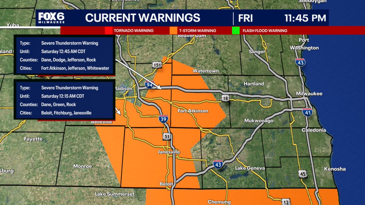
10:02pm Friday: Storms are about to cross the river into Wisconsin from Iowa. Good news here. Nothing is severe and no watches are currently anticipated for our area. So sleep easy and make sure you have emergency alerts on just in case. It’s possible these storms perk a bit overnight (arrival after 1-2am in Milwaukee). But as of now, concern is starting to decrease for widespread severe weather. We will be watching.
11:32pm: A dangerous weather situation is unfolding across Milwaukee & Waukesha counties where Flash Flood Warnings are in effect. The rain is just not stopping. We've had unconfirmed reports of water rescues and flooding on the interstate system. We are monitoring the situation closely tonight. Stay off the roads if you can and check your basements and sump pumps. The rain will continue for several more hours.
7/11 10:52 PM
We have had a busy day in the weather department. Saturday has a chance for some storms in the evening. The forecast trends brighter with a "Happy Holly Forecast" on Sunday and the start of next week.
https://t.co/8PEkdfmuNh
-Holly Baker
We caught the Timmerman Microburst on our Brown Deer Towercam (north of Milwaukee) on Sunday night. Wild. This is looking WSW toward Timmerman. You'll see the rain coming in from the left (south). Note the dark area that drops in the rain. That is likely what caused the 82mph wind at Timmerman and the wind damage in the area. Notice how it hits the ground and how it dissipates quickly.
3:44pm: Scattered showers will continue moving in from the north over the next few hours before fizzling this evening. Two big stories on Friday. First...wildfire smoke from Canada. Second...strong afternoon/evening storms with wind & hail. Stay tuned for updates.
A Severe Thunderstorm Warning has been issued for parts of SE WI until 3/15 12:45AM. Make sure your cell phone emergency alerts are set to "ON." Tune into FOX6, Download the FOX6 Storm Center App & FOX Local App for the latest information.
2/18 10:35pm: We will gradually climb out of this cold after Wednesday. Much warmer by Sunday and Monday. As of now, no big snowstorms in sight. There is one missing us down to the south and that southern storm track that we saw in January seems to be setting up once again. Expect more temperatures drops late in the month into early March.
oooh I thought you had to own a Switch to get the free headphones!
I was wrong. I got mine this morning!
You have another week to register I believe. https://t.co/84WulwKBvp #recroom#nintendoswitch#headphones#recroomupdate