BREAKING: Sen. Alan Peter Cayetano concedes as the Senate President.
“I may leave the position of SP, but I am honored to still be your PS — your Public Servant.” Cayetano said in his post.
Visit https://t.co/KsDi9LLzzD for more updates.
LOOK: Sped-up camera footages of ash emission from the Kanlaon Volcano summit crater at 5:21 PM today, 16 June 2026. This event generated grayish plumes that rose 400 meters above the crater before drifting southwest, as captured by the IP camera at Kanlaon Volcano Observatory–Canlaon City (KVO-CC). A total of 20 ash emission events have been recorded since yesterday, generating 100 to 500 meter-tall plumes that drifted to the general southwest. Alert Level 2 remains in effect over Kanlaon Volcano.
#KilalaninAngPinas 𝗗𝗢 𝗬𝗢𝗨 𝗟𝗜𝗩𝗘 𝗡𝗘𝗔𝗥 𝗔 𝗩𝗢𝗟𝗖𝗔𝗡𝗢? 🌋
As we commemorate the 35th anniversary of the cataclysmic eruption of #Pinatubo, let’s get to know more about the volcanoes in the Philippines.
The Philippines sits in a highly active geologic setting, making it prone to earthquakes and volcanic eruptions. Beyond its faults and trenches, the country has 𝗺𝗼𝗿𝗲 𝘁𝗵𝗮𝗻 𝟰𝟬𝟬 𝗸𝗻𝗼𝘄𝗻 𝘃𝗼𝗹𝗰𝗮𝗻𝗼𝗲𝘀, many of which are actually familiar mountains, according to PHIVOLCS.
𝗔𝗖𝗧𝗜𝗩𝗘 𝗩𝗢𝗟𝗖𝗔𝗡𝗢𝗘𝗦 are those with recorded historical eruptions or geological evidence of eruptions within the last 10,000 years. These are the most hazardous, as they can erupt again and threaten nearby communities. PHIVOLCS lists 24 active volcanoes nationwide, with Mayon Volcano in Albay being the most active, having over 50 recorded eruptions.
𝗣𝗢𝗧𝗘𝗡𝗧𝗜𝗔𝗟𝗟𝗬 𝗔𝗖𝗧𝗜𝗩𝗘 𝗩𝗢𝗟𝗖𝗔𝗡𝗢𝗘𝗦, formerly called “dormant,” have youthful landforms and may have erupted within the last 10,000 years but lack recorded historical eruptions. Although they are not showing current activity, they are still closely monitored due to the possibility of sudden reactivation, as seen in the 1991 Pinatubo eruption.
Mount Apo, the highest peak in the Philippines, is one of the 27 classified volcanoes under this category, with sulfur deposits hinting at past volcanic activity.
𝗜𝗡𝗔𝗖𝗧𝗜𝗩𝗘 𝗩𝗢𝗟𝗖𝗔𝗡𝗢𝗘𝗦 have no known eruptions and are highly eroded, often showing deep gullies and worn-down structures. Many Philippine mountains fall under this category, with around 360 inactive volcanoes identified by PHIVOLCS today. Even Laguna de Bay, a caldera, is classified as an inactive volcano.
#EarthquakePH#EarthquakeDavaoOriental#iFelt_DavaoOrientalEarthquake
Earthquake Information No.2
Date and Time: 15 June 2026 - 05:18 PM
Magnitude = 6.2
Depth = 094 km
Location = 06.13°N, 126.95°E - 113 km S 59° E of Governor Generoso (Davao Oriental)
Reported Intensities:
Intensity V - Governor Generoso, DAVAO ORIENTAL; Jose Abad Santos, DAVAO OCCIDENTAL
Intensity IV - Alabel, Glan, Kiamba, and Malapatan, SARANGANI; City of Koronadal, Tampakan, and Tupi, SOUTH COTABATO; City of General Santos, CITY OF GENERAL SANTOS; City of Tacurong, SULTAN KUDARAT
Intensity III - City of Mati, DAVAO ORIENTAL; Banga, Norala, Polomolok, Surallah, and T'Boli, SOUTH COTABATO
Intensity II - City of Davao, CITY OF DAVAO; City of Kidapawan, M'lang, Matalam, and President Roxas, COTABATO; Maasim, and Maitum, SARANGANI; Lake Sebu, Santo Niño, and Tantangan, SOUTH COTABATO
Intensity I - Carmen, COTABATO; City of Tandag, SURIGAO DEL SUR
Instrumental Intensities:
Intensity IV - City of Digos, DAVAO DEL SUR; Kiamba, SARANGANI; City of Koronadal, and Tupi, SOUTH COTABATO
Intensity III - Nabunturan, DAVAO DE ORO; Magsaysay, DAVAO DEL SUR; Maitum, SARANGANI; Surallah, SOUTH COTABATO; City of General Santos, CITY OF GENERAL SANTOS
Intensity II - City of Davao, CITY OF DAVAO; City of Kidapawan, M'lang, and President Roxas, COTABATO; Malungon, SARANGANI
Intensity I - Santa Maria, DAVAO OCCIDENTAL; Carmen, COTABATO; Malapatan, SARANGANI; T'Boli, SOUTH COTABATO
https://t.co/DbVHFQTRqH
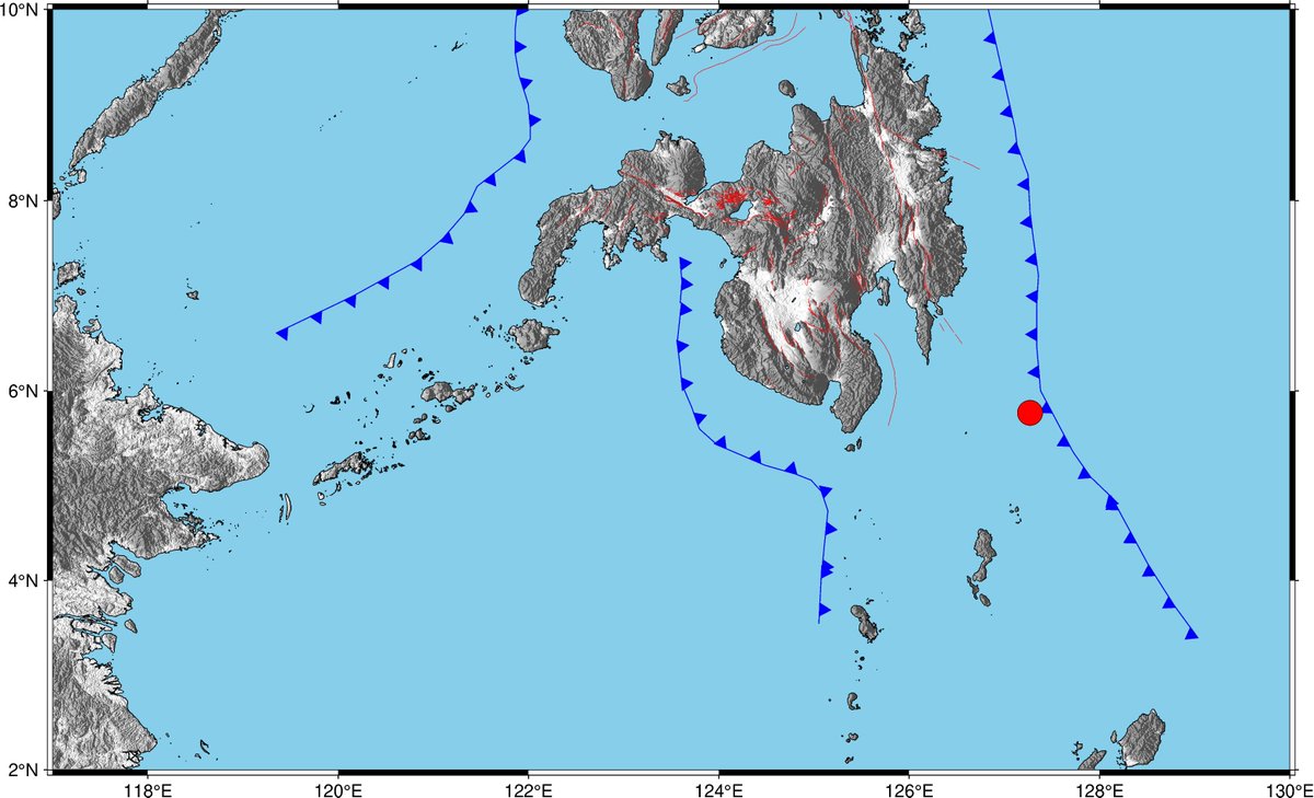
#EarthquakePH#EarthquakeDavaoOriental#iFelt_DavaoOrientalEarthquake
Earthquake Information No.1
Date and Time: 15 June 2026 - 05:18 PM
Magnitude = 6.6
Depth = 086 km
Location = 05.77°N, 127.27°E - 164 km S 53° E of Governor Generoso (Davao Oriental)
Instrumental Intensities:
Intensity III - City of General Santos, SOUTH COTABATO
Intensity II - Digos City, DAVAO DEL SUR; Malungon, SARANGANI; Koronadal City, Tupi, SOUTH COTABATO
Intensity I - Magsaysay, DAVAO DEL SUR; Sta. Maria, DAVAO OCCIDENTAL; Nabunturan, DAVAO DE ORO; Kiamba, Malapatan, Maasim, SARANGANI; TBoli, SOUTH COTABATO
https://t.co/argpML6LND
📷Coastal Uplift sa Sarangani at Davao Occidental
Ang paggalaw ng Cotabato Trench na nagdulot ng Magnitude 7.8 Offshore Sarangani Earthquake noong June 8, 2026 ang tumulak paitaas sa ilang bahagi ng baybayin sa Sarangani at Davao Occidental. Ito ay nagresulta sa halos 2 metrong coastal uplift o pag-angat ng ilalim ng dagat (seabed) na dating nakalubog sa tubig.
Dahil sa uplift, lumawak ang lupain sa dalampasigan (umabot sa 200 metro sa ilang lugar) at nagbago ang lebel na naabot ng tubig-dagat (tide level).
Ang ganitong landform na nabuo pagkatapos ng isang malakas na lindol ay hindi nagpapahiwatig na may padating pa na tsunami.
#PHIVOLCS #QRT #EarthquakePH #SaranganiEarthquake #Landslide #Liquefaction #DOSTPHIVOLCS #HandaAngMayAlam